气候及其成因
章节大纲
-
Lesson Objectives
::经验教训目标- Define climate.
::界定气候。
- State how climate is related to latitude.
::说明气候与纬度的关系。
- Explain how oceans influence climate.
::解释海洋如何影响气候。
- Describe how mountains affect climate.
::描述山区如何影响气候。
Lesson Vocabulary
::词汇表课程- climate
::气候气候
- rain shadow
::雨下阴影
Introduction
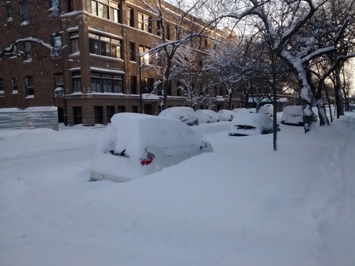
::导言One winter day in Chicago, the temperature hit 20° C (68° F). This would be normal for Miami in the winter, but in Chicago, it felt like a heat wave. The scene in Figure is more typical for Chicago in the winter. The “heat wave” on that winter day is an example of weather. The typical temperature for that day is part of Chicago’s climate.
::芝加哥某天冬天,气温达到20摄氏度(68°F ) 。 在迈阿密,这在冬季是正常的,但在芝加哥,这感觉像热浪。 图中的场景在冬季更常见。 冬天的“热浪”就是天气的例子。 那天的典型温度是芝加哥气候的一部分。Cold and snow are typical for Chicago in the winter.
::寒冷和积雪是芝加哥冬季的典型现象What Is Climate?
::什么是气候?Climate is the average weather of a place over many years. It includes average temperatures. It also includes average precipitation. The timing of precipitation is part of climate as well. What determines the climate of a place? Latitude is the main factor. A nearby ocean or mountain range can also play a role.
::气候是多年以来一个地方的平均天气。 它包括平均温度。 它还包括平均降水量。 降水时间也是气候的一部分。 降水时间是什么决定一个地方的气候? 纬度是主要因素。 附近的海洋或山脉也可以发挥作用。Latitude and Climate
::纬度和气候Latitude is the distance north or south of the equator. It’s measured in degrees, from 0° to 90°. Several climate factors vary with latitude.
::纬度是赤道以北或以南的距离,以零度至90度的度度度测量,若干气候因素因纬度而异。Latitude and Temperature
::纬度和温度Temperature changes with latitude. You can see how in Figure
::温度随纬度而变化。您可以看到图中是如何变化的- At the equator, the sun’s rays are most direct. Temperatures are highest.
::在赤道,太阳的射线最直接,温度最高。
- At higher latitudes, the sun’s rays are less direct. The farther an area is from the equator, the lower is its temperature.
::在高纬度地区,太阳的射线不那么直接。 距离赤道越远,温度就越低。
- At the poles, the sun’s rays are least direct. Much of the area is covered with ice and snow, which reflect a lot of sunlight. Temperatures are lowest here.
::在极台上,太阳的光线最不直接。 大部分地区都覆盖着冰雪,这反映了许多阳光。 这里的温度最低。
Find the cool spot in Asia at 30° north latitude. Why is it cool for its latitude? (Hint: What else might influence temperature?)
::在亚洲北纬30度的北纬地区找到冷点。 为什么其纬度冷却? (提示:还有什么会影响温度? )Latitude and Precipitation
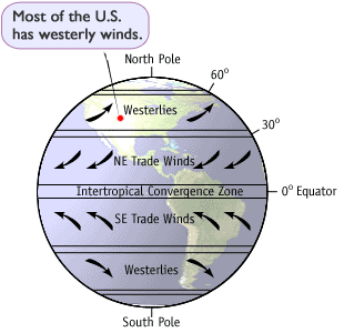
::纬度和降水Global air currents affect precipitation. How they affect it varies with latitude. You can see why in Figure .
::全球空气流会影响降水量,它们如何影响降水量随纬度而变化。您可以看到图中的原因。Global air currents are shown on the left. You can see how they affect climate on the right.
::全球空气流在左边显示。您可以看到它们是如何影响右边气候的。Latitude and Prevailing Winds
::纬度和流行风风Global air currents cause global winds. Figure shows the direction that these winds blow. Global winds are the prevailing, or usual, winds at a given latitude. The winds move air masses, which causes weather.
::全球气流引发全球风。 图显示这些风吹向的方向。 全球风是特定纬度的风,或通常的风。 风会移动空气质量, 造成天气。The direction of prevailing winds determines which type of air mass usually moves over an area. For example, a west wind might bring warm moist air from over an ocean. An east wind might bring cold dry air from over a mountain range. Which wind prevails has a big effect on the climate. What if the prevailing winds are westerlies? What would the climate be like?
::流行风的方向决定了哪种类型的空气质量通常在某一地区移动。 例如, 西方风可能会从海洋上空带来温暖的潮湿空气。 东方风可能会从山脉上空带来冷淡的干燥空气。 哪个风会给气候带来很大影响 。 如果流行风是西风呢? 气候会怎样?The usual direction of the wind where you live depends on your latitude. This determines where you are in the global wind belts.
::你所居住的风向的通常方向取决于你的纬度。这决定了你在全球风带中的位置。Oceans and Climate
::海洋与气候Coastal and Inland Climates
::和沿海内陆气候When a place is near an ocean, the water can have a big effect on the climate.
::当一个地方靠近海洋时,水能对气候产生巨大影响。These three cities are at the same latitude. They are San Francisco, CA; Wichita, KS; and Virginia Beach, VA. How close these cities are to the ocean is important. Also important is the direction the winds are blowing at this location.
::这三座城市位于同一个纬度。它们是旧金山、加利福尼亚、威奇塔、KS和弗吉尼亚海滩。这些城市离海洋有多近非常重要。同样重要的是风吹向这个地点的方向。When a place is near an ocean, the water can have a big effect on the climate.
::当一个地方靠近海洋时,水能对气候产生巨大影响。Places at the same latitude may have very different climates if one is on a coast and one is inland.
::如果位于海岸和内陆,同一纬度同一地点的气候可能大不相同。- On the coast, the climate is affected by warm moist air from the ocean. A coastal climate is usually mild. Summers aren’t too hot, and winters aren’t too cold. can be high due to the moisture in the air. This is a maritime climate.
::在沿海,气候受到海洋温暖潮湿空气的影响。 沿海气候通常比较温和。 夏天并不热,冬天也不太冷。 由于空气中的湿度,气候可能很高。 这是一个海洋气候。
- Further inland, the climate is affected by cold or hot air from the land. This air may be dry, because it comes from over land. An inland climate is usually more extreme. Winters may be very cold, and summers may be very hot. can be low. This is a continental climate.
::更远的内陆地区,气候受到来自陆地的寒冷或热空气的影响。这种空气可能是干燥的,因为它来自陆地。内陆气候通常更极端。冬季可能非常寒冷,夏季可能非常热。这可是一个大陆气候。
The ocean has a big effect on climate. This is obvious when you compare the temperatures of these three cities. Each of these cities is located at 37°N latitude. They are within the westerly winds. ( Figure )
::海洋对气候有很大影响。 当你比较这三个城市的温度时, 这一点很明显。 每个城市都位于37摄氏纬度, 它们都在西风中。 (图)How does the ocean influence the climate of these three cities?
::海洋如何影响这三个城市的气候?The climate of San Francisco is affected by the Pacific Ocean. The cool California current comes from the north. Upwelling brings cold water from the deep. So the water offshore is cold. Virginia Beach is near the Atlantic Ocean. But its temperatures are more like Wichita than San Francisco. Why is the climate in Virginia Beach less influenced by the ocean than San Francisco? Hint : Think about the normal direction of the winds at that latitude. The weather in San Francisco comes from over the Pacific Ocean. Much of the weather in Virginia comes from the continent.
::旧金山的气候受到太平洋的影响。 加利福尼亚州冷酷的洋流来自北方。 上升从深海带来冷水。 因此, 岸外的水是冷的。 弗吉尼亚海滩在大西洋附近。 但是它的温度比旧金山更像维希塔。 为什么弗吉尼亚海滩的气候比旧金山受到的海洋影响要小? 提示: 想想那个纬度的风向的正常方向。 旧金山的天气来自太平洋上空。 弗吉尼亚的天气大部分来自大陆。Ocean Currents and Climate
::洋流和气候Ocean currents carry warm or cold water throughout the world’s oceans. They help to even out the temperatures in the oceans. This also affects the temperature of the atmosphere and the climate around the world. Currents that are near shore have a direct impact on climate. They may make the climate much colder or warmer. You can see examples of this in Figure .
::海洋洋流在全世界海洋中承载着温暖或冷水,有助于平衡海洋温度,也影响到大气温度和世界气候。 海岸附近的洋流对气候有直接影响。它们可能使气候更加寒冷或温暖。您可以从图中看到这方面的例子。The Gulf Stream moves warm equatorial water up the western Pacific and into northern Europe, where it raises temperatures in the British Isles.
::海湾溪向西太平洋和北欧移动温暖的赤道水,提高不列颠群岛的气温。Mountains and Climate
::山地气候和气候委员会Did you ever hike or drive up a mountain? Did you notice that it was cooler near the top? Climate is not just different on a mountain. Just having a mountain range nearby can affect the climate.
::你曾徒步或驾车登山吗?你有没有注意到顶部附近更冷? 气候并不只是山上的气候。只要附近有山脉就可以影响气候。Altitude and Temperature
::高度和温度Air temperature falls at higher altitudes. You can see this in Figure . Why does this happen? Since air is less dense at higher altitudes, its molecules are spread farther apart than they are at sea level. These molecules have fewer collisions, so they produce less heat.
::高海拔高度的空气温度会下降。您可以从图中看到这一点。为什么发生这种情况?由于高海拔的空气密度较低,其分子会比海平面的分子分散得更远。这些分子的碰撞较少,因此产生的热量也较少。Air temperature drops as you go higher.
::气温上升时会下降Look at the mountain in Figure . The peak of Mount Kilimanjaro, Tanzania (Africa, 3° south latitude) is 6 kilometers (4 miles) above sea level. At 3°S it’s very close to the equator. At the bottom of the mountain, the temperature is high year round. How can you tell that it’s much cooler at the top?
::看看图中的山峰。坦桑尼亚乞力马扎罗山峰(非洲,南纬3°)比海平面高6公里(4英里 ) 。 在3°S,它离赤道非常近。在山底,温度是一年一轮高的。你怎么看出来顶部更冷?Mount Kilimanjaro has very different climates at the top and bottom.
::乞力马扎罗山的顶部和底部气候非常不同。Mountains and Precipitation
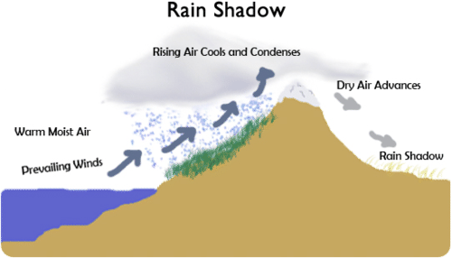
::山地和降坡Mountains can also affect precipitation. Mountains and mountain ranges can cast a rain shadow . As winds rise up a mountain range the air cools and precipitation falls. On the other side of the range the air is dry and it sinks. So there is very little precipitation on the far (leeward) side of a mountain range. Figure shows how this happens.
::山岳也可以影响降水量。 山岳和山脉可以投下雨影。 当风向向山岳升起时, 空气会冷却, 降水会降下来。 在山脉的另一边, 空气是干燥的, 它会沉没。 因此远处( 向外) 的山脉上几乎没有降水。 图显示这种情况是如何发生的 。What role do prevailing winds play in a rain shadow?
::风在雨影中起什么作用?Lesson Summary
::经验教训摘要- Climate is the average weather of a place over many years. It varies with latitude. It may also be influenced by nearby oceans or mountains.
::气候是多年来一个地方的平均天气,随纬度而异,也可能受到附近海洋或山岳的影响。
- Temperature falls from the equator to the poles. Global air currents create wet and dry zones at different latitudes. They also create global winds.
::温度从赤道降为极。全球空气流在不同纬度形成湿带和干区。它们也形成全球风。
- Oceans influence the climate of coasts. A coastal climate is mild. It may also get plenty of rain. An inland climate has greater temperature extremes. It can also be dry.
::海洋影响沿海气候,沿海气候温和,也可能降雨量大,内陆气候温度极端,也可能干燥。
- The air is cooler as you go higher up a mountain. Mountain ranges can also cast rain shadows.
::高山时空气更凉爽 山脉也能投下雨影
Lesson Review Questions
::经验回顾问题Recall
::回顾- What is climate?
::什么是气候?
- Describe how temperature changes with latitude.
::描述温度如何随纬度变化。
- Why are many deserts found near 30° latitude?
::为什么在纬度30度附近发现许多沙漠?
- How does altitude influence temperature?
::高度如何影响温度?
- What is a rain shadow?
::什么是雨影?
Apply Concepts
::应用概念- An ocean current flows from north to south off the western coast of a continent. The current flows close to land at 50° N latitude. Predict how the current affects the climate of the coast at that latitude. Explain your prediction.
::洋流从一个大陆的西海岸向北向南流动,洋流接近北纬50度的陆地,预测洋流如何影响该纬度的海岸气候,解释你的预测。
Think Critically
::仔细仔细思考- Explain how prevailing winds influence climate.
::解释风如何影响气候。
- Compare and contrast coastal and inland climates.
::比较和对比沿海和内陆气候。
Points to Consider
::需要考虑的要点In this lesson, you read how latitude, oceans, and mountains affect climate.
::在这个教训中,你读到纬度、海洋和山岳是如何影响气候的。- Do you think you could predict the climate of a place, based on its location?
::你认为你能预测一个地方的气候吗? 根据它的位置?
- Do you think that similar locations around the globe might have the same climate?
::你认为全球类似地点的气候 可能是一样的吗?
- Define climate.