探索俄罗斯地区(3天)
章节大纲
-
Chapter Challenges
::章次 挑战-
Name the major cities, rivers, and economic base of Russia’s core region.
::列出俄罗斯核心地区的主要城市、河流和经济基础。 -
Identify the economic base of cities in the Eastern Frontier and the identity of the world’s most voluminous freshwater lake.
::确定东部边境城市的经济基础和世界上最庞大的淡水湖的特性。 -
Describe the physical attributes of Siberia and the Far East.
::描述西伯利亚和远东的物理特征。 -
Explain why Chechnya has been at war with Russia twice since 1994.
::解释为什么车臣自1994年以来两次与俄罗斯交战。 -
Learn why Russia invaded Georgia in 2008 and discover the role of fossil fuels in the economies of Armenia and Azerbaijan.
::了解俄罗斯为何于2008年入侵格鲁吉亚, 并发现化石燃料在亚美尼亚和阿塞拜疆经济中的作用。
Student Learning Objectives
::学生学习目标TEKS Regional Unit 6:Russia, the Caucasus and Central Asia; Chapter 6.3 Exploring the Regions of Russia
::TEKS 区域股6:俄罗斯、高加索和中亚;第6.3章 " 探索俄罗斯地区 "WG.4A Explain how elevation, latitude, wind systems, ocean currents, position on a continent, and mountain barriers influence temperature, precipitation, and distribution of climate regions.
::WG.4A 解释高海拔、纬度、风力系统、洋流、大陆位置、山地屏障如何影响气候区域的温度、降水量和分布。WG.4B Describe different landforms and the physical processes that cause their development.
::WG.4B 描述不同的土地形态和导致其发展的物理过程。WG.4C Explain the influence of climate on the distribution of biomes in different regions.
::WG.4C 解释气候对不同区域生物群落分布的影响。5A Analyze how the character of a place is related to its political, economic, social, and cultural elements.
::5A 分析一个地方的特征如何与其政治、经济、社会和文化因素相关。6B Explain the processes that have caused changes in settlement patterns, including urbanization, transportation, access to and availability of resources, and economic activities.
::6B 解释导致住区模式变化的进程,包括城市化、运输、获得和获得资源以及经济活动。WG.7B Examine benefits and challenges of globalization, including connectivity, standard of living, pandemics, and loss of local culture.
::WG.7B 审查全球化的好处和挑战,包括连通性、生活水平、流行病和当地文化的丧失。WG.8A Compare ways that humans depend on, adapt to, and modify the physical environment, including the influences of culture and technology.
::WG.8A 比较人类依赖、适应和改变自然环境的方式,包括文化和技术的影响。WG.8B Describe the interaction between humans and the physical environment and analyze the consequences of extreme weather and other natural disasters such as El Niño, floods, tsunamis, and volcanoes.
::WG.8B 描述人类与自然环境之间的相互作用,分析极端天气和厄尔尼诺、洪水、海啸和火山等其他自然灾害的后果。WG.9A Identify physical and/or human factors such as climate, vegetation, language, trade networks, political units, river systems, and religion that constitute a region.
::WG.9A 查明构成区域的自然和/或人类因素,如气候、植被、语言、贸易网络、政治单位、河流系统和宗教。WG.10B Classify where specific countries fall along the economic spectrum between free enterprise and communism.
::WG.10B 将特定国家属于自由企业和共产主义之间经济范畴的领域分类。WG.11A Understand the connections between levels of development and economic activities (primary, secondary, tertiary, and quaternary).
::WG.11A 了解发展水平与经济活动(初等、中等、高等教育和四年级)之间的联系。WG.11C Assess how changes in climate, resources, and infrastructure (technology, transportation, and communication) affect the location and patterns of economic activities.
::WG.11C 评估气候、资源和基础设施(技术、运输和通信)的变化如何影响经济活动的地点和模式。WG.16C Explain ways various groups of people perceive the characteristics of their own and other cultures, places, and regions differently.
::WG.16C 解释不同群体对自身和其他文化、地方和区域特征的不同看法。WG.17A Describe and Compare patterns of culture such as language, religion, land use, education, and customs that make specific regions of the world distinctive.
::WG.17A 描述和比较使世界特定区域具有独特性的语言、宗教、土地使用、教育和习俗等文化模式。WG.18A Analyze cultural changes in specific regions caused by migration, war, trade, innovations, and diffusion.
::WG.18A 分析移徙、战争、贸易、创新和传播在特定区域造成的文化变化。WG.19C Examine the environmental, economic, and social impacts of advances in technology on agriculture and natural resources.
::WG.19C 审查技术进步对环境、经济和社会对农业和自然资源的影响。WG.21C Create and interpret different types of maps to answer geographic questions, infer relationships, and analyze change.
::WG.21C 创建和解释不同类型的地图,以回答地理问题、推断关系和分析变化。WG.22A Design and Draw appropriate graphics such as maps, diagrams, tables, and graphs to communicate geographic features, distributions, and relationships.
::WG.22A 设计和绘制适当的图形,如地图、图表、表格和图表,以交流地理特征、分布和关系。WG.22B Generate summaries, generalizations, and thesis statements supported by evidence.
::WG.22B 编写摘要、概述和有证据佐证的论文陈述。WG.22C Use geographic terminology correctly.
::WG.22C 正确使用地理术语。WG.22D Use standard grammar, spelling, sentence structure, and punctuation.
::WG.22D 使用标准语法、拼写、句子结构和标点。The Core Region Exploring the Regions of Russia
::探索俄罗斯地区核心地区Most of Russia’s population and its major industries are located west of the Ural Mountains on the Russian Plain. Known as Russia’s geographic core, this includes the Moscow region, the Volga region, and the Ural Mountain region. Moscow, Russia’s capital city, anchors a central industrial area that is home to more than 50 million people. Moscow alone has more than ten million residents, with about 13 million in its metropolitan area.
::俄罗斯大部分人口及其主要产业位于俄罗斯平原乌拉尔山脉以西。 被称为俄罗斯地理核心的俄罗斯包括莫斯科地区、伏尔加地区和乌拉尔山区。 俄罗斯首都莫斯科是5 000多万人居住的中央工业区。 仅莫斯科就有1 000多万居民,约1 300万人居住在首都地区。A ring of industrial cities surrounding Moscow contains vital production centers of Russian manufacturing. During the Communist era, Moscow expanded from its 19th century core and became an industrial city with planned neighborhoods. This world-class city has an extensive subway and freeway system that is expanding to meet current growth demands. Although rents, commodities, and domestic goods had fixed prices during the Communist era, the Soviet Union’s collapse changed all that. Today Moscow is one of the most expensive places to live in the world, with prices based on supply and demand.
::莫斯科周围的工业城市环环环有俄罗斯制造业的重要生产中心。 在共产主义时代,莫斯科从19世纪的核心发展到19世纪,成为工业城市,有规划的邻里。 这个世界级城市拥有庞大的地铁和高速公路系统,正在扩大以满足当前的增长需求。 尽管在共产主义时代租金、商品和国内商品都有固定价格,但苏联的崩溃改变了这一切。 如今,莫斯科是世界上最昂贵的地方之一,价格以供求为基础。St. Petersburg is Russia’s second largest city, with a population of about five million. Located on the Baltic Sea, it is western Russia’s leading port city. The city was renamed Petrograd (1914–24) and Leningrad (1924–91) but today is often called Petersburg, or just “Peter” for short. Peter the Great built the city with the help of European architects in the early 18th century to rival other European capitals, and he made it the capital of the Russian Empire.
::圣彼得堡是俄罗斯第二大城市,人口约500万。 位于波罗的海,是俄罗斯西部的主要港口城市。 这座城市更名为彼得罗格勒(1914—24 ) 和列宁格勒(1924—91 ) , 但今天常常被称为彼得堡,或简称“彼得 ” ( Peter ) 。 彼得大帝在欧洲建筑师的帮助下,于18世纪初建造了这座城市,以对抗其他欧洲国家的首都,并将之作为俄罗斯帝国的首都。Named after St. Peter in the Bible (not Peter the Great), St. Petersburg is a cultural center for Russia and a major tourist destination. It is also known for shipbuilding, oil and gas trade, manufacturing, and finance. Its greatest tragedy took place when it was under siege for 29 months by the German military during World War II. About one million civilians died of starvation or during the bombardment, and hundreds of thousands fled the city, leaving the city nearly empty by the end of the siege.
::圣彼得在《圣经》中以圣彼得命名(不是彼得大帝),圣彼得堡是俄罗斯的文化中心和主要旅游目的地。 圣彼得堡也以造船、石油和天然气贸易、制造和金融闻名。 其最大的悲剧发生在二战期间德国军队围困29个月。 大约100万平民死于饥饿或轰炸,数十万人逃离城市,在围困结束时几乎空无一人。
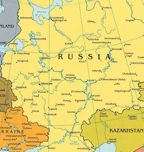
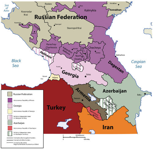
This map illustrates Russia's core regions.
::这一地图显示了俄罗斯的核心地区。
To the far north of St. Petersburg on the Barents Sea are the cities of Murmansk and Arkhangelsk. Murmansk is a major military port for Russia’s navy and nuclear submarine fleet. Warm water from the North Atlantic drift circles around Norway to keep this northern port city fairly free of ice. Arkhangelsk (which means “archangel”), used as a port for lumber exports, has a much shorter ice-free season than Murmansk. Both of these cities are in Russia’s far north, with long winters and brief summers.
::摩尔曼斯克是俄罗斯海军和核潜艇舰队的主要军事港口。 北彼得堡最北端的巴伦支海是摩尔曼斯克市和阿尔汉盖尔斯克市。 摩尔曼斯克是俄罗斯海军和核潜艇舰队的主要军事港口。 北大西洋漂流环绕挪威的温暖水流圈,让北部港口城市免受冰块的侵袭。 作为木材出口港口的阿尔汉格尔斯克(Arkhangelsk ) ( “ archangel ” ) ( Archangelsk ) 与摩尔曼斯克(Murmansk ) 相比,其无冰季要短得多。 这两个城市都位于俄罗斯最北端,冬季长,夏季短暂。The Volga River flows through the core region of Russia, providing transportation, fresh water, and fishing. The Volga is the longest river in Europe at 2,293 miles, and it drains most of Russia’s western core region. This river has been a vital link in the transportation system of Russia for centuries and connects major industrial centers from the Moscow region to the south through an extensive network of canals and other waterways. The Volga River flows into the Caspian Sea, and a canal links the Volga with the Black Sea through a connecting canal via the Don River.
::伏尔加河流经俄罗斯核心地区,提供了交通、淡水和渔业。 伏尔加河是欧洲最长的河流,为2,293英里,耗尽了俄罗斯大部分西部核心地区。 几世纪以来,伏尔加河一直是俄罗斯运输系统的重要环节,通过广泛的运河和其他水道网络将莫斯科地区的主要工业中心连接到南部。 伏尔加河流入里海,通过东河连接运河将伏尔加河与黑海连接起来。At the eastern edge of Russia’s European core lie the Ural Mountains, which act as a natural divide between Europe and Asia. These low-lying mountains have an abundance of minerals and fossil fuels, which make the Ural Mountains ideal for industrial development. The natural resources of the Urals and the surrounding area provide raw materials for manufacturing and export. The eastern location kept these resources out of the hands of the Nazis during World War II, and the resources themselves helped in the war effort. Oil and natural gas exploration and development have been extensive across Russia’s core region and have greatly increased Russia’s export profits.
::俄罗斯欧洲核心的东部边缘是乌拉尔山脉,这是欧洲和亚洲之间的天然鸿沟。 这些低洼山区拥有丰富的矿物和化石燃料,这使得乌拉尔山脉成为工业发展的理想。 乌拉尔山脉及其周边地区的自然资源为制造业和出口提供了原材料。 东部地区在二战期间将这些资源排除在纳粹手中,资源本身也帮助了战争努力。 石油和天然气勘探与发展在俄罗斯的核心地区十分广泛,极大地增加了俄罗斯的出口利润。
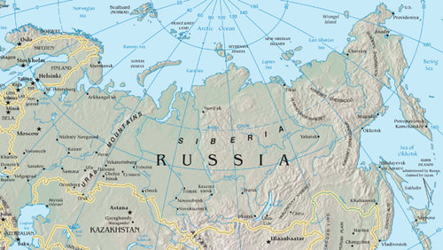
This map illustrates Russia's eastern frontier, the Far East, and Siberia.
::这个地图显示了俄罗斯的东部边界,远东和西伯利亚。The Eastern Frontier
::东部边境East of the Urals, in south-central Russia, is Russia’s Eastern Frontier, a region of planned cities, industrial plants, and raw-material processing centers. The population is centered in two zones here: the Kuznetsk Basin (or Kuzbas, for short) and the Lake Baikal region.
::俄罗斯中南部的乌拉尔东区是俄罗斯的东边疆区,由规划的城市、工厂和原材料加工中心组成。 人口集中在这里的两个地区:库兹涅茨克盆地(简称库兹巴斯 ) 、 贝加尔湖地区。The Kuzbas is a region of coal, iron ore, and bauxite mining; timber processing; and steel and aluminum production industries. Central industrial cities were created across the Eastern Frontier to take advantage of these resource opportunities. The most important of these is Novosibirsk, the third largest city in Russia after Moscow and St. Petersburg and home to about 1.4 million people. The city is not only noted for its industries but it is also the region’s center for the arts, music, and theater. It is host to a music conservatory and a philharmonic orchestra, a division of the Russian Academy of Sciences, and three major universities.
::库兹巴斯是一个煤炭、铁矿石和铝土开采、木材加工、钢铁和铝生产工业的地区。 中央工业城市是在整个东部边境创建的,目的是利用这些资源的机会。 其中最重要的城市是新西伯利亚克,这是俄罗斯继莫斯科和圣彼得堡之后第三大城市,居住着大约140万人。 这座城市不仅因其工业而闻名,而且还是艺术、音乐和剧院的中心。 它是一个音乐学院、交响乐团、俄罗斯科学院的一个分部和三所主要大学的东道主。Agriculture, timber, and mining are the main economic activities in the eastern Lake Baikal region, which is more sparsely settled than the Kuzbas. Lake Baikal (400 miles long, 50 miles wide) holds more fresh water than all the US Great Lakes together and about 20 percent of all the liquid fresh water on the earth’s surface. Its depth has been recently measured at 5,370 feet (more than a mile). Some of the longest river systems in the world flow through the Eastern Frontier.
::农业、木材和采矿是巴伊卡尔湖东部地区的主要经济活动,该地区比库兹巴斯地区更稀少。 巴伊卡尔湖(400英里长,50英里宽 ) 拥有的淡水比所有美国大湖地区都多,占地表所有液体淡水的20%左右。 其深度最近被测量为5,370英尺(超过1英里 ) 。 世界上一些最长的河流系统通过东部边境流动。The Irtysh, Ob, Yenisey, and Lena are the main rivers that flow north through the region into Siberia and on to the Arctic Ocean. To the east, the Amur River creates the border between Russia and China until it flows north into the Sea of Okhotsk. In addition to waterways, the Trans-Siberian Railway is the major transportation link through the Eastern Frontier, connecting Moscow with the port city of Vladivostok in the Far East.
::Irtysh、Ob、Yenisey和Lena是穿过该区域向北流动到西伯利亚和北冰洋的主要河流。在东部,阿穆尔河建立了俄罗斯和中国之间的边界,直到俄罗斯和中国向北流动到奥霍茨克海。除了水道外,跨西伯利亚铁路是穿越东部边境的主要运输通道,连接莫斯科和远东海参海口城市。Siberia
::西伯利亚Siberia, as a place name, refers to all of Asian Russia east of the Ural Mountains, including the Eastern Frontier and the Russian Far East. However, in this and some other geography textbooks, the term Siberia more specifically describes only the region north of the Eastern Frontier that extends to the Kamchatka Peninsula. The word Siberia conjures up visions of a cold and isolated place, which is true. Stretching from the northern Ural Mountains to the Bering Strait, Siberia is larger than the entire United States but is home to only about 15 million people. Its cities are located on strategic rivers with few overland highways connecting them.
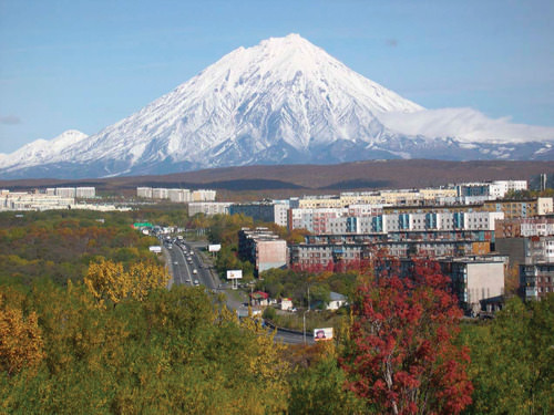
::西伯利亚作为一个地名,指乌拉尔山脉以东的所有亚洲俄罗斯,包括东边边境和俄罗斯远东,然而,在本书和其他一些地理教科书中,西伯利亚一词更具体地描述的只是延及堪察特卡半岛的东边边境以北地区,西伯利亚一词指一个寒冷和孤立的地方的景象,这是事实。西伯利亚从北乌拉尔山脉延伸至白令海峡,西伯利亚比整个美国要大,但只有大约1 500万人居住,其城市位于战略河流上,连接它们的陆地高速公路很少。Type D (continental) climates dominate the southern portion of this region, and the territory consists mainly of coniferous forests in a biome called the taiga. This is one of the world’s largest taiga regions. Type E (polar) climates can be found north of the taiga along the coast of the Arctic Sea, where the tundra is the main physical landscape. No trees grow in the tundra because of the semifrozen ground. Permafrost may thaw near the surface during the short summer season but is permanently frozen beneath the surface. On the eastern edge of the continent, the mountainous Kamchatka Peninsula has 20 active volcanoes and more than 100 inactive volcanoes. It is one of the most active geological regions on the Pacific Rim.
::D型(大陆)气候在这一地区的南部占主导地位,领土主要由称为泰加的生物群落中的隐形森林组成。这是世界上最大的泰加地区之一。在北冰洋沿岸的泰加以北可以发现E型(极地)气候,北冰洋是主要自然景观,苔原是主要自然景观。由于半冻土,苔原上没有树木生长。在短短的夏季里,全氟辛烷磺酸可能会在地表附近融化,但被永久冻结在地表之下。在大陆东部边缘,卡姆恰特卡山脉有20个活火山和100多个活火山。它是太平洋里姆最活跃的地质区域之一。
Mount Koryasky, an Active Volcano, and Petropavlovsk-Kamchatsky, a Town on Russia’s Kamchatka Peninsula.
::俄罗斯堪察卡半岛的一个城镇Petropavlovsk-Kamchatsky。
The vast northern region of Russia is sparsely inhabited but holds enormous quantities of natural resources such as oil, timber, diamonds, natural gas, gold, and silver. There are vast resources in Siberia waiting to be extracted, and this treasure trove will play an important role in Russia’s economic future.
::俄罗斯广大的北部地区人口稀少,但拥有大量自然资源,如石油、木材、钻石、天然气、黄金和银。 西伯利亚有大量资源等待开采,这一宝藏将在俄罗斯经济未来发挥重要作用。The Far East
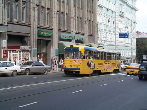
::远东Vladivostok Tram Opposite the Admiral’s Club on Its Way to the Railway Station, Vladivostok.
::海参维斯托克铁道对面海军司令俱乐部前往海参沃斯托克火车站的路上。
Across the strait from Japan is Russia’s Far East region, with the port of Vladivostok (population about 578,000) as its primary city. Bordering North Korea and China, this Far East region is linked to Moscow by the Trans-Siberian Railway. Before 1991, Vladivostok was closed to outsiders and was an important army and naval base for the Russian military. Goods and raw materials from Siberia and nearby Sakhalin Island were processed here and shipped west by train. Sakhalin Island and its coastal waters have oil and mineral resources. Industrial and business enterprises declined with the collapse of the Soviet Union in 1991. Today, the Far East is finding itself on the periphery of Russia’s hierarchy of productivity. However, it has the potential to emerge again as an important link to the Pacific Rim markets.
::横穿日本海峡的两岸是俄罗斯的远东地区,其首要城市是海参沃斯托克港(人口约578,000人 ) 。 北韩和中国相邻的远东地区与莫斯科有跨西伯利亚铁路连接。 1991年以前,海参沃斯托克对外人关闭,是俄罗斯军队的一个重要的军队和海军基地。 西伯利亚和附近的萨哈林岛的货物和原材料在这里加工,用火车向西运送。 萨哈林岛及其沿海水域拥有石油和矿产资源。 1991年苏联解体后,工业和商业企业倒闭。 如今,远东地区处于俄罗斯生产力等级的边缘。 然而,它有可能再次成为与太平洋环环礁市场的重要连接点。Southern Russia
::南俄罗斯In the southern portion of the Russian core lies a land bridge between Europe and Southwest Asia. This is a region dominated by the Caucasus Mountains. To the west is the Black Sea, and to the east is the landlocked Caspian Sea. The Caucasus Mountains, higher than the European Alps, were formed by the Arabian tectonic plate moving northward into the Eurasian plate. The highest peak is Mount Elbrus at 18,510 feet. Located on the border between Georgia and Russia, Mount Elbrus is the highest peak on the European continent as well as the highest peak in Russia.
::俄罗斯核心的南部是欧洲和西南亚之间的一座陆地桥梁。这是一个由高加索山脉占优势的区域。西是黑海,东是内陆里海。高加索山脉比欧洲阿尔卑斯山脉高,由阿拉伯构造板块向北移入欧亚板块。最高的山峰是埃尔布鲁斯山,位于格鲁吉亚和俄罗斯边界,埃尔布鲁斯山是欧洲大陆最高山峰,也是俄罗斯最高山峰。Most of this region was conquered by the Russian Empire during the 19th century and held as part of the Soviet Union in the 20th century. However, only a minority of its population is ethnic Russian. Its people consist of at least 50 ethnic groups speaking a variety of languages.
::该地区大部分地区在19世纪被俄罗斯帝国征服,在20世纪被作为苏联的一部分而占领,但人口中只有少数是俄罗斯人,人口至少有50个民族,讲多种语言。Since the collapse of the Soviet Union, the Caucasus region has been the main location of unrest within Russia. Wars between Russia and groups in the Caucasus have claimed thousands of lives. Some of the non-Russian territories of the Caucasus would like to become independent, but Russia fears an unraveling of its country if their secession is allowed to proceed. To understand why the Russians have fought the independence of places such as Chechnya but did not fight against the independence of other former Soviet states in the Caucasus such as Armenia, it is necessary to study the administrative structure of Russia itself.
::自苏联解体以来,高加索地区一直是俄罗斯内部动乱的主要地点。 俄罗斯与高加索地区各集团之间的战争夺走了数千人的生命。 高加索地区一些非俄罗斯领土希望独立,但俄罗斯担心如果允许其分离,俄罗斯的国家会解体。 要理解俄罗斯人为什么为车臣等地的独立而斗争,但没有为亚美尼亚等高加索地区其他前苏联国家的独立而斗争,就必须研究俄罗斯本身的行政结构。
This map illustrates the Republics of Southern Russia, Including Chechnya.
::该地图显示了包括车臣在内的俄罗斯南部共和国。
Of the 21 republics, eight are located in southern Russia in the Caucasus region. One of these, the Chechen Republic (or Chechnya), has never signed the Federation Treaty to join the Russian Federation. In fact, Chechnya proposed independence after the breakup of the Union of Soviet Socialist Republics (USSR). Although other territories to the south of Chechnya, such as Georgia, Armenia, and Azerbaijan, also declared their independence from Russia after 1991, they were never administratively part of Russia.
::在21个共和国中,8个位于高加索地区的俄罗斯南部,其中1个车臣共和国(车臣共和国)从未签署加入俄罗斯联邦的《联邦条约》,事实上,在苏维埃社会主义共和国联盟解体后,车臣提议独立,尽管车臣以南的其他领土,如格鲁吉亚、亚美尼亚和阿塞拜疆在1991年以后也宣布独立于俄罗斯,但它们在行政上从未是俄罗斯的一部分。During the Soviet era, those countries were classified as Soviet Socialist Republics, so it was easy for them to become independent countries when all the other republics (e.g., Ukraine, Belarus, and Kazakhstan) did so after 1991. However, Chechnya was administratively part of the USSR with no right to secession. After 1991, Russia decided that it would not allow territories that had been administratively governed by Russia to secede and has fought wars to prevent that from happening. It feared the consequences if all 21 republics within the Russian Federation were declared independent countries.
::在苏联时代,这些国家被归类为苏维埃社会主义共和国,因此,当所有其他共和国(如乌克兰、白俄罗斯和哈萨克斯坦)在1991年之后成为独立国家时,它们很容易成为独立国家。 但是,车臣在行政上是苏联的一部分,无权分离。 1991年之后,俄罗斯决定不允许曾被俄罗斯行政管辖的领土分离,并发动战争以防止这种情况发生。 它担心如果俄罗斯联邦境内所有21个共和国被宣布为独立国家,将会带来后果。Chechnya has fought against Russia for independence twice since the USSR’s collapse. The First Chechen War (1994–96) ended in a stalemate, and Russia allowed the Chechens to have de facto independence for several years. But in 1999, Russia resumed military action, and by 2009 the war was essentially over and Chechnya was once more under Russia’s control. Between 25,000 and 50,000 Chechens were killed in the war, and between 5,000 and 11,000 Russian soldiers were also killed. In 2003, the United Nations called Grozny, Chechnya’s capital, the most destroyed city on Earth. Reconstruction of Grozny has slowly begun.
::自苏联解体以来,车臣两次与俄罗斯为独立而斗争。 第一次车臣战争(1994-96年)陷入僵局,俄罗斯允许车臣人事实上独立数年。 但1999年,俄罗斯恢复了军事行动,到2009年,战争基本结束了,车臣再次在俄罗斯控制之下。 战争中,有25 000至50 000车臣人被杀,还有5 000至11 000俄罗斯士兵被杀。 2003年,联合国称为车臣首都格罗兹尼(车臣首都 ) , 地球上被摧毁最严重的城市。 格罗兹尼的重建缓慢开始。Even before the recent wars, Chechnya had a difficult past. Over the course of its history, it has been at the boundary between the Ottoman Empire, the Persian Empire, and the Russian Empire. Most of the people converted to Sunni Islam in the 1700s to curry favor with the Ottomans and seek their protection against Russian encroachment. Nevertheless, Chechnya was annexed by the Russian Empire. During Soviet leader Josef Stalin’s regime, more than 500,000 Chechens were loaded on train cars and shipped to Kazakhstan, where as many as one-half died.
::甚至在最近的战争之前,车臣就经历了一个艰难的过去。 在其历史上,车臣一直处在奥斯曼帝国、波斯帝国和俄罗斯帝国之间的边界。 大多数人在1700年代改信逊尼派伊斯兰教,为奥斯曼人讨好咖喱,并寻求保护以免受俄罗斯入侵。 尽管如此,车臣还是被俄罗斯帝国吞并了。 在苏联领导人斯大林(Josef Stalin)执政期间,有500,000多名车臣人坐上了火车,被运到哈萨克斯坦,在那里死亡人数高达一半。Transcaucasia
::外高加索The independent countries of Georgia, Armenia, and Azerbaijan make up the region of Transcaucasia. Although they are independent countries, they are included in this chapter because they have more ties to Russia than to the region of Southwest Asia to their south. They have been inextricably connected to Russia ever since they were annexed by the Russian Empire in the late 18th and early 19th centuries, and they were all former republics within the Soviet Union. When the Soviet Union collapsed in 1991, these three small republics declared independence and separated from the rest of what became Russia.
::独立的格鲁吉亚、亚美尼亚和阿塞拜疆国家组成外高加索地区。 虽然它们是独立国家,但它们被列入本章,因为它们与俄罗斯的关系比与南亚南部的西南亚地区更为密切。 自从它们在18世纪末和19世纪初被俄罗斯帝国兼并以来,它们就与俄罗斯有着不可分割的联系,它们都是苏联内的前共和国。 当苏联于1991年崩溃时,这三个小共和国宣布独立并脱离了后来成为俄罗斯的其他地区。Geographically, these three countries are located on the border between the European and Asian continents. The Caucasus Mountain range is considered the dividing line. The region known as Transcaucasia is generally designated as the southern portion of the Caucasus Mountain area.
::从地理上讲,这三个国家位于欧洲和亚洲大陆之间的边界上,高加索山脉被认为是分界线,外高加索地区一般被称为高加索山区的南部。
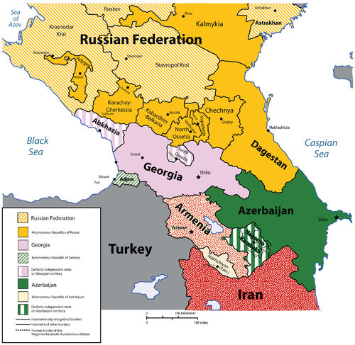
This map illustrates southern Russia and Transcaucasia.
::这幅地图显示了俄罗斯和外高加索的南部。
The country of Georgia has a long history of ancient kingdoms and a golden age including invasions by the Mongols, Ottomans, Persians, and Russians. For three years—from 1918 to 1921—Georgia was independent. After fighting an unsuccessful war to remain free after the Russian Revolution, Georgia was absorbed into the Soviet Union. Since it declared independence in 1991, the country has struggled to gain a stable footing within the world community.
::格鲁吉亚有着悠久的古老王国历史和黄金时代,包括蒙古人、奥斯曼人、波斯人和俄罗斯人的入侵,从1918年到1921年,格鲁吉亚独立了三年,在俄罗斯革命后为自由而战不成功的战争之后,格鲁吉亚被吸收到苏联,自1991年宣布独立以来,格鲁吉亚一直在为在国际社会中取得稳定地位而奋斗。Unrest in the regions of South Ossetia, Abkhazia, and Adjara (where the populations are generally not ethnic Georgian) has destabilized the country, making it more difficult to engage in the global economy. Russia and Georgia had a military conflict in 2008, when Russian troops entered the South Ossetian region to support its move toward independence from Georgia.
::南奥塞梯、阿布哈兹和阿扎拉地区(那里的人口一般不是格鲁吉亚人)的不安定状态使格鲁吉亚动荡不安,使其更难参与全球经济。 2008年,俄罗斯和格鲁吉亚爆发了军事冲突,俄罗斯军队进入南奥塞梯地区支持其从格鲁吉亚独立出来。Georgia considered South Ossetia to be a part of Georgia and called the Russians an occupying force. Many other countries, including the United States, condemned Russia for their action. Russian troops pulled out of Georgia but supported the independence of South Ossetia and Georgia’s westernmost region of Abkhazia. Neither South Ossetia nor Abkhazia are considered independent states by most of the world’s countries.
::格鲁吉亚认为南奥塞梯是格鲁吉亚的一部分,并称俄罗斯为占领军。 包括美国在内的许多其他国家都谴责俄罗斯的行动。 俄罗斯军队撤出了格鲁吉亚,但支持南奥塞梯和格鲁吉亚最西部的阿布哈兹地区独立。 世界上大部分国家都不认为南奥塞梯或阿布哈兹是独立国家。A democratic-style central government has emerged in Georgia, and economic support has been provided by international aid and foreign investments. The country has made the switch from the old Soviet command economy to a free-market economy. Agricultural products and tourism have been Georgia’s main economic activities.
::格鲁吉亚出现了民主式中央政府,国际援助和外国投资也提供了经济支持。 格鲁吉亚已经从旧的苏联指挥经济转向自由市场经济。 农产品和旅游业一直是格鲁吉亚的主要经济活动。In 2010, Armenia, to the south of Georgia, had a population of only about three million in a physical area smaller in size than the US state of Maryland. It is a country with its own distinctive alphabet and language and was the first country in the world to adopt Christianity as a state religion, an event traditionally dated to 301 C.E. The Armenian Apostolic Church remains the country’s central religious institution, and the Old City of Jerusalem in Israel has an Armenian Quarter, an indication of Armenia’s early connection with Christianity.
::2010年,在格鲁吉亚南部,亚美尼亚人口只有大约300万,其面积小于美国马里兰州。 亚美尼亚是一个有自己独特的字母和语言的国家,是世界上第一个将基督教作为国教的国家,这一活动传统上为301中世纪。 亚美尼亚教廷仍然是国家的核心宗教机构,以色列耶路撒冷老城有一个亚美尼亚区,这表明亚美尼亚早期就与基督教有联系。The small landlocked country has experienced invasions from every empire that controlled the region throughout history. The geographic area of the country decreased when the Ottoman Empire took control of western Armenia, and that region remains a part of Turkey to this day. A bitter conflict between Turks and Armenians during World War I resulted in the systematic deaths of as many as a million Armenians. This genocide continues to be commemorated annually on April 24, the traditional date of the Armenian Martyrs’ Day, but Turkey still denies the events were genocide.
::历史上控制该地区的每一个帝国都对内陆小国发动了侵略。 当奥斯曼帝国控制了亚美尼亚西部时,这个国家的地理区域缩小了,而该地区至今仍是土耳其的一部分。 第一次世界大战期间,土耳其人和亚美尼亚人之间的激烈冲突造成多达100万亚美尼亚人系统性死亡。 每年4月24日亚美尼亚烈士日这一传统日子,这一种族灭绝事件每年继续发生,但土耳其仍然否认这些事件是种族灭绝。Like the other former Soviet republics, Armenia has shifted from a centrally planned economy to a market economy. Before independence in 1991, Armenia’s economy had a manufacturing sector that provided other Soviet republics with industrial goods in exchange for raw materials and energy. Since then, its manufacturing sector has declined and Armenia has fallen back on agriculture and financial remittances from the approximately eight million Armenians living abroad to support its economy. These remittances, along with international aid and direct foreign investments, have helped stabilize Armenia’s economic situation.
::与其他前苏联共和国一样,亚美尼亚已经从中央计划经济转向市场经济。 1991年独立前,亚美尼亚经济有一个制造业部门向其他苏维埃共和国提供工业产品以换取原材料和能源。 从那时以来,亚美尼亚的制造业部门已经衰退,亚美尼亚从海外大约800万亚美尼亚人那里收回了农业和汇款以支持其经济。 这些汇款,加上国际援助和直接外国投资,帮助稳定了亚美尼亚的经济状况。Azerbaijan is an independent country to the east of Armenia bordering the Caspian Sea. It is about the same size in area as the US state of Maine. This former Soviet republic has a population of more than eight million in which more than 90 percent are Muslims. Azerbaijan shares a border with the northern province of Iran, which is also called Azerbaijan. Part of Azerbaijan is located on the western side of Armenia and is separated from the rest of the country.
::阿塞拜疆是亚美尼亚东部与里海接壤的独立国家,面积与美国缅因州的面积大致相同。这个前苏联共和国有800多万人口,其中90%以上是穆斯林。阿塞拜疆与伊朗北部省(也称为阿塞拜疆)接壤。阿塞拜疆的一部分位于亚美尼亚西部,与该国其他地区分离。Located on the shores of the Caspian Sea , Baku is the capital of Azerbaijan and is the largest city in the region, with a population approaching two million. During the Cold War era, it was one of the top five largest cities in the Soviet Union. The long history of this vibrant city and the infusion of oil revenues have given rise to a metropolitan center of activity that has attracted global business interests. Wealth has not been evenly distributed in the country, and at least one-fourth of the population still lives below the poverty level.
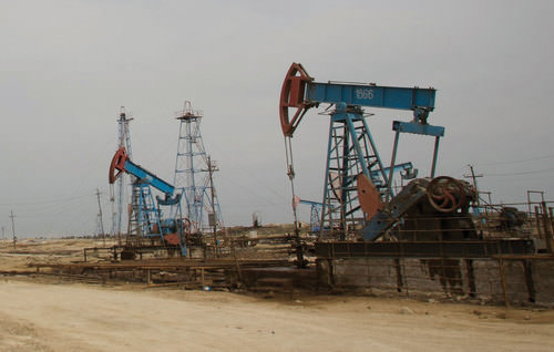
::巴库位于里海沿岸,是阿塞拜疆的首都,是该地区最大的城市,人口接近200万。冷战时期,巴库是苏联前五大城市之一。这个充满活力的城市的漫长历史和石油收入的注入已经形成了一个吸引全球商业利益的都市活动中心。 财富在阿塞拜疆没有平均分配,至少四分之一的人口仍然生活在贫困线以下。Azerbaijan is rich with oil reserves. Petroleum was discovered here in the 8th century, and hand-dug oil wells produced oil as early as the 15th century. Since the Industrial Revolution, the rising value of petroleum for energy increased the industrial extraction of oil in Azerbaijan. At the end of the 19th century, this small country produced half of the oil in the world. Oil and natural gas are the country’s main export products and have been a central focus of its economy. Large oil reserves are located beneath the Caspian Sea, and offshore wells with pipelines to shore have expanded throughout the Caspian Basin.
::阿塞拜疆拥有丰富的石油储备。 8世纪在这里发现了石油,早在15世纪就在这里发现了人工挖掘的油井生产了石油。 自工业革命以来,石油对能源的不断上涨增加了阿塞拜疆石油的工业开采。 19世纪末,这个小国生产了世界石油的一半。 石油和天然气是阿塞拜疆的主要出口产品,一直是其经济的中心焦点。 大量的石油储备位于里海之下,拥有通往岸边管道的离岸油井在整个里海盆地扩张。As much as the export of oil and natural gas has been an economic support for the country, it has not been without costs to the environment. According to US government sources, local scientists consider parts of Azerbaijan to be some of the most devastated environmental areas in the world. Serious air, soil, and water pollution exist due to uncontrolled oil spills and the heavy use of chemicals in the agricultural sector.
::尽管石油和天然气出口一直是对阿塞拜疆的经济支持,但环境并非没有代价。 根据美国政府的消息来源,当地科学家认为阿塞拜疆的部分地区是世界上遭受破坏最严重的环境地区。 由于不受控制的石油泄漏和农业部门大量使用化学品,空气、土壤和水污染严重。
This photo shows the oilfields of Azerbajain.
::这张照片展示了Azerbajain的油田。
Key Takeaways
::密钥外出-
The vast majority of Russia’s population live in the western core area of the country, the region around the capital city of Moscow.
::俄罗斯绝大多数人口居住在俄罗斯的西部核心地区,即首都莫斯科附近的地区。 -
Most of the cities on the Barents Sea and in the Eastern Frontier were established for manufacturing or for the exploitation of raw materials.
::巴伦支海和东部边境的大多数城市是为制造或开发原材料而建立的。 -
The Volga River and its tributaries have been an important transportation network for centuries. The Volga is the longest river in Europe.
::几个世纪以来,伏尔加河及其支流一直是一个重要的运输网络,伏尔加河是欧洲最长的河流。 -
Very few people live in Siberia, but the region is rich with natural resources.
::生活在西伯利亚的人口很少,但该区域自然资源丰富。 -
The most contentious region in Russia is the Caucasus Mountain region, especially the area of Chechnya.
::俄罗斯争议最大的地区是高加索山区地区,特别是车臣地区。 -
The Caucasus is characterized by ethnic and religious diversity and by a desire for independence from Russia.
::高加索的特点是族裔和宗教多样性,希望摆脱俄罗斯独立。 -
South of Russia in the Caucasus is the region of Transcaucasia. It is ethnically, religiously, and linguistically diverse. Countries there are independent of Russia, although they have a long history of being part of the Russian and Soviet Empires. Some of the countries are rich in petroleum reserves.
::俄罗斯南高加索地区的高加索地区是外高加索地区,在种族、宗教和语言上是多种多样的。 那里的一些国家独立于俄罗斯,尽管它们长期以来一直是俄罗斯和苏维埃帝国的一部分。 其中一些国家拥有丰富的石油储备。
Vocabulary Terms
::词汇术语术语Chapter 6.3 Exploring the Regions of Russia
::第6.3章 探索俄罗斯地区Baltic Republics
::波罗的海各共和国The countries of Latvia, Lithuania, and Estonia, located on the eastern coast of the Baltic sea
::拉脱维亚、立陶宛和爱沙尼亚三国位于波罗的海东海岸Berlin Wall
::柏林墙A wall erected by East Germany in 1961 to cut the capital of Berlin in two, and later dismantled in 1989
::1961年东德为将柏林首府分割成两部分而修建隔离墙,1961年东德修建隔离墙,1989年拆除Central Asia
::中亚 中亚A region that includes the republics of Kazakhstan, Kyrgyzstan, Tajikistan, Turkmenistan, and Uzbekistan
::包括哈萨克斯坦、吉尔吉斯斯坦、塔吉克斯坦、土库曼斯坦和乌兹别克斯坦等共和国的区域Chechnya
::车臣车臣One of the republics that remains a part of Russia after the collapse of the Soviet Union despite independence movements and violent upheaval
::苏联解体后,尽管出现了独立运动和暴力动乱,仍属于俄罗斯一部分的共和国之一Cold War
::冷战冷战The conflict between the U.S and the Soviet Union after WWII, called "Cold" because it never escalated into open warfare
::二战后美国和苏联之间的冲突 被称为"冷战" 因为它从未升级为公开战争collective farm
::集体农场An enormous farm in the Soviet Union on which a large team of laborers was gathered to work together during Joseph Stalin's reign
::在苏联的一个庞大的农场上 聚集了一大批工人 在约瑟夫·斯大林统治时期command economy
::命令经济A type of economic system in which production of goods and services is determined by a central government, which usually owns the means of production
::一种经济体系,其货物和服务的生产由通常拥有生产手段的中央政府决定Eurasia
::欧亚The combined continent of Europe and Asia
::欧洲和亚洲大陆的结合market economy
::市场经济、市场经济和市场经济A type of economic system in which production of goods and services are determined by the demand from consumers; often called a demand economy or capitalism
::一种经济体系,其中货物和服务的生产由消费者的需求决定;通常称为需求经济或资本主义privatization
::私有化私有化The selling of government-owned business to private citizens. This occurred after the collapse of communism in Russia
::将国有企业出售给私人公民,这是在俄罗斯共产主义崩溃后发生的。Red Army
::红军红军The name of the Soviet Union's military
::苏联军队的名称Russian Revolution
::俄罗斯革命The revolt of 1917, in which the Russian communist party, led by V.I Lenin, took control of the government from the czars
::1917年的起义,俄罗斯共产党在V. I. 列宁领导的1917年起义中,从沙皇手中控制了政府。Silk Road
::丝绸之路The 4,000-mile route between China and the Mediterranean sea, named for the costly sills acquired in China
::中国与地中海之间的4 000英里路线,以中国购置的昂贵的硅石命名Soviet Union/USSR
::苏联/苏联The Union of Soviet Socialist Republics formed in 1922 by the communists and officially dissolved in 1991
::苏维埃社会主义共和国联盟于1922年由共产党组成,于1991年正式解散supra
::前注Georgian term for dinner party, with many dishes and courses, toasts, and short speeches
::以格鲁吉亚语举办晚宴, 有许多菜盘、课程、吐司、简短演讲,Trans-Siberian Railroad
::横跨西西伯利亚铁路A railroad that would eventually link Moscow to the Pacific port of Vladivostok; built between 1891 and 1903
::一条铁路,最终将连接莫斯科与太平洋海参沃斯托克港;在1891年至1903年期间建造Applying Knowledge
::应用知识Discussion and Study Questions
::讨论和研究问题-
What are Russia’s four main regions and what are the main qualities of each?
::俄罗斯的四个主要地区是什么? 每一个地区的主要特点是什么? -
What connects Moscow with Russia’s Far East, and why is this important?
::莫斯科与俄罗斯远东有何关联, -
What are some of the major environmental problems in Russia and Transcaucasia?
::俄罗斯和外高加索的一些重大环境问题是什么? -
What is the relationship between the countries of Georgia and Russia? Describe their 2008 conflict.
::格鲁吉亚和俄罗斯国家之间的关系是什么?描述2008年的冲突。 -
What happened to Chechnya? Why has Russia fought two wars in Chechnya since the Soviet Union’s collapse?
::车臣怎么了? 自苏联解体以来,为什么俄罗斯在车臣打过两次战争? -
What are the three independent countries of Transcaucasia, and when did they gain independence from Russia?
::三个独立的外高加索国家是什么国家,它们何时从俄罗斯获得独立? -
Which of the three Transcaucasian countries has the least opportunity to gain wealth? What is the largest source of income in this region?
::三个外高加索国家中哪一个最没有机会获得财富? 该地区最大的收入来源是什么? -
What physical feature demarcates the boundary between Europe and Asia in southern Russia?
::在俄罗斯南部,什么物理特征划定了欧洲和亚洲之间的边界? -
What is the largest city in Transcaucasia? On what sea is it located?
::外高加索最大的城市在哪里?
Real-World Geography Exercise
::现实世界地理演习Using , locate each one of the physical regions below. From the list, choose 10 and calculate the distance and how long it would take to travel by airplane from your hometown to the nearest airport of your chosen location.
::使用 , 确定下面每个物理区域的位置。 从列表中选择 10, 并计算从您家乡乘飞机前往您所选择地点最近的机场的距离和所需时间。-
Abkhazia
::阿布哈兹 -
Adjara
::阿贾拉 -
Arctic Ocean
::北冰洋 -
Amur River
::阿穆尔河 -
Arkhangelsk
::阿尔汉格尔斯克 -
Armenia
::亚美尼亚 亚美尼亚 -
Azerbaijan
::阿塞拜疆 阿塞拜疆 阿塞拜疆 -
Baku
::巴库 -
Baltic Sea
::波罗的海 -
Bering Strait
::白令海峡 -
Black Sea
::黑海黑海黑海 -
Caspian Sea
::里里海 -
Chechnya
::车臣车臣 -
Don River
::东河 -
Eastern Frontier
::东部边境 -
Georgia
::格鲁吉亚 格鲁吉亚 格鲁吉亚 -
Grozny
::格罗兹尼 -
Irtysh River
::伊尔蒂什河 -
Kamchatka Peninsula
::堪察卡半岛 -
Kuznetsk Basin
::库兹涅茨克盆地 -
Lake Baikal
::贝加尔湖 -
Lena River
::莱那河 -
Murmansk
::摩尔曼斯克 -
Mt. Elbrus
::Mt. Elbrus山 -
Novosibirsk
::新西伯利亚语Name -
Ob River
::上河河 -
Sakhalin Island
::萨哈林岛 -
Sea of Okhotsk
::霍霍次克海 -
Siberia
::西伯利亚 -
South Ossetia
::南奥塞梯 -
Transcaucasia
::外高加索 -
Vladivostok
::符拉迪沃斯托克 -
Volga River
::伏尔加河
Mapping Exercise
::绘图绘制作业ESRI GEO Inquiry
::ESRI GEGO调查: Student’s will explore the Silk Roads transfer of goods, ideas, and disease yesterday and today.Mapping Our World Module 5 Lesson 1
::绘制我们的世界单元5第一课程: Boundaries are invisible lines on the Earth’s surface. They divide the surface area into distinct political entities. In this activity, students will use GIS to investigate different types of international boundaries, explore the implications of various boundary configurations, and observe boundary changes that occurred in recent years.
::: 边界是地球表面的无形线条。它们将表面积划分为不同的政治实体。在这一活动中,学生将使用地理信息系统调查不同类型的国际边界,探讨各种边界配置的影响,并观察近年来发生的边界变化。Videos for Geography Enrichment
::地理丰富视频Helpful Websites for the Study of Geography
::地理研究有用网站is an encyclopedia funded by the Canadian government covering all branches of knowledge. Their scholarly collection includes interactive materials.
::该百科全书由加拿大政府资助,涵盖所有知识分支,其学术收藏包括交互式材料。provides information on the people, history, government, economy, energy, geography, communications, transportation, military, and transnational issues for the world's entities.
::向世界各实体提供关于人民、历史、政府、经济、能源、地理、通信、运输、军事和跨国问题的资料。is a US government website where you can find federal legislation, past and present, as well as information about the US legal system.
::是一个美国政府的网站,您可以在此找到过去和现在的联邦立法以及关于美国法律制度的信息。is a government agency website that provides current news, resources, topics of interest, information about drugs, careers in the DEA, and a tip hotline.
::是一个政府机构网站,提供最新消息、资源、感兴趣的话题、毒品信息、在缉毒局的职业以及一条小费热线。is the largest library in the world and provides manuscripts, files, information, pictures, and videos.
::图书馆是世界上最大的图书馆,提供手稿、文件、信息、图片和录像。is a US government agency website that allows users to search for and retrieve satellite images of Earth.
::这是一个美国政府机构的网站,用户可以搜索和检索地球的卫星图像。is a US government website that provides historical documents, photos, records, publications, and educator resources.
::这是一个美国政府网站,提供历史文件、照片、记录、出版物和教育资源。is a US government agency website that provides weather-related information and ocean research.
::是一个提供气象信息和海洋研究的美国政府机构网站。is a website by the United States Geological Survey and other federal, state, and local agencies that delivers topographic information for the United States.
::这是美国地质调查局和其他联邦、州和地方机构为美国提供地形信息的网站。is a massive central data source and a handy way to graphically compare nations.
::是一个庞大的中央数据源,是用图形比较国家的一种方便方式。is a website that measures most locations in the world for air pollution in real time.
::是一个实时测量世界上大多数空气污染地点的网站。is a unique statistical database, which allows you to research and compare a multitude of different data on US states.
::这是一个独特的统计数据库, 使你能够研究和比较关于美国各州的多种不同数据。is an international organization founded in 1945 and made up of 193 member states. The UN maintains international peace and security, protects human rights, delivers humanitarian aid, promotes sustainable development, and upholds international law.
::联合国是一个国际组织,成立于1945年,由193个成员国组成。 联合国维护国际和平与安全,保护人权,提供人道主义援助,促进可持续发展,维护国际法。is a US government agency that provides a population clock, data, surveys, statistics, a library with information and infographics, news about the economy, and much more.
::这是一个美国政府机构,它提供人口钟、数据、调查、统计、一个拥有信息和信息资料的图书馆、关于经济的新闻,以及更多。is a US government agency website that provides scientific information about the natural hazards that threaten lives, the natural resources we rely on, the health of our ecosystems and environment, and the impacts of climate and land-use change.
::这是一个美国政府机构的网站,提供科学信息,说明威胁生命的自然危害、我们赖以生存的自然资源、生态系统和环境的健康以及气候和土地使用变化的影响。is a US government website that provides the latest presidential news, information about the budget, policy, defense, and many more topics.
::提供最新总统新闻、预算、政策、国防等资讯, 以及更多议题。is under the United Nations and provides leadership on matters critical to health, shapes the research agenda on health, and monitors the health situation and assessing health trends around the world. Their website provides information on the state of health around the world, outbreaks, current health news, and more.
::网站提供世界各地卫生状况、疫情爆发、最新卫生新闻等信息。is an intergovernmental organization that regulates international trade. The website provides information on the history of the multilateral trading system, featured videos, news and events, trade topics, and more.
::该网站提供关于多边贸易体系历史的信息、视频、新闻和事件、贸易专题等等。 -
Name the major cities, rivers, and economic base of Russia’s core region.