中亚(2天)
章节大纲
-
Chapter Challenges
::章次 挑战-
Understand that Central Asia is a landlocked region that receives little rainfall and has to rely on water from major rivers flowing from the mountains in the east.
::中亚是一个内陆地区,降雨量很少,必须依赖东部山区主要河流的水。 -
Summarize how Central Asia has been transitioning from a Soviet-dominated region to independent states and what has been occurring in the various states to adapt to the new economic environment.
::总结一下中亚从一个苏联主导的地区向独立国家过渡的情况,以及各国为适应新的经济环境而正在发生的情况。 -
Describe how the Aral Sea has been affected by the practices of water use in the region and the environmental consequences that have resulted from water use policies.
::说明咸海如何受到该区域用水做法和用水政策造成的环境后果的影响。 -
Explain the geopolitical history of Afghanistan and why this area has been so difficult to govern under a central government.
::解释阿富汗的地缘政治历史,以及该地区为何在中央政府统治下如此难以治理的原因。 -
Learn why there is continual conflict in Afghanistan between Western military forces and local Taliban insurgents.
::了解为什么阿富汗西部军队与当地塔利班叛乱分子之间冲突持续不断。 -
Understand the principle that globalization of the economy forces political units to compete over natural resources.
::理解经济全球化迫使政治单位争夺自然资源的原则。
Student Learning Objectives
::学生学习目标TEKS Regional Unit 06: Russia, the Caucasus, and Central Asia: Chapter 6.4 Central Asia
::TEKS 区域股06:俄罗斯、高加索和中亚:中亚:第6.4章WG.2A Describe the human and physical characteristics of the same regions at different periods of time to evaluate relationships between past events and current conditions.
::WG.2A 描述不同时期同一区域的人的和自然的特征,以评估过去事件与当前状况之间的关系。WG.2B Explain how changes in societies have led to diverse uses of physical features.
::WG.2B 解释社会变化如何导致对物理特征的多种利用。WG.3B Describe the physical processes that affect the environments of regions, including weather, tectonic forces, erosion, and soil-building processes.
::WG.3B 描述影响区域环境的物理过程,包括天气、构造力、侵蚀和土壤建设过程。WG.4C Explain how elevation, latitude, wind systems, ocean currents, position on a continent, and mountain barriers influence temperature, precipitation, and distribution of climate regions.
::WG.4C 解释高海拔、纬度、风力系统、洋流、大陆位置、山地屏障如何影响气候区域的温度、降水量和分布。WG.4B Describe different landforms and the physical processes that cause their development.
::WG.4B 描述不同的土地形态和导致其发展的物理过程。WG.6A Locate and describe human and physical features that influence the size and distribution of settlements.
::WG.6A 确定并描述影响定居点规模和分布的人文和物理特征。WG.8A Compare ways that humans depend on, adapt to, and modify the physical environment, including the influences of culture and technology.
::WG.8A 比较人类依赖、适应和改变自然环境的方式,包括文化和技术的影响。WG.9A Identify physical and/or human factors such as climate, vegetation, language, trade networks, political units, river systems, and religion that constitute a region.
::WG.9A 查明构成区域的自然和/或人类因素,如气候、植被、语言、贸易网络、政治单位、河流系统和宗教。WG.10B Classify where specific countries fall along the economic spectrum between free enterprise and communism.
::WG.10B 将特定国家属于自由企业和共产主义之间经济范畴的领域分类。WG.10C Compare the ways people satisfy their basic needs through the production of goods and services such as subsistence agriculture versus commercial agriculture or cottage industries versus commercial industries.
::WG.10C 比较人们通过生产商品和服务满足其基本需要的方式,如自给农业,而不是商业农业或家庭手工业,而不是商业工业。WG.12A Analyze how the creation, distribution, and management of key natural resources affects the location and patterns of movement of products, money, and people.
::WG.12A 分析关键自然资源的创造、分配和管理如何影响产品、货币和人员流动的地点和模式。WG.13A Interpret maps to explain the division of land, including man-made and natural borders, into separate political units such as cities, states, or countries.
::WG.13A 解释地图,解释土地划分,包括人造边界和自然边界,分为不同的政治单位,如城市、州或国家。WG.16C Explain ways various groups of people perceive the characteristics of their own and other cultures, places, and regions differently.
::WG.16C 解释不同群体对自身和其他文化、地方和区域特征的不同看法。WG.16D Compare life in a variety of urban and rural areas in the world to evaluate political, economic, social, and environmental changes.
::WG.16D 比较世界不同城市和农村地区的生活,以评价政治、经济、社会和环境变化。WG.18A Analyze cultural changes in specific regions caused by migration, war, trade, innovations, and diffusion.
::WG.18A 分析移徙、战争、贸易、创新和传播在特定区域造成的文化变化。WG.18C Identify examples of cultures that maintain traditional ways, including traditional economies.
::WG.18C 查明保持传统方式的文化实例,包括传统经济。WG.19C Examine the environmental, economic, and social impacts of advances in technology on agriculture and natural resources.
::WG.19C 审查技术进步对环境、经济和社会对农业和自然资源的影响。WG.21B Locate places of contemporary geopolitical significance on a map.
::WG.21B 在地图上标出具有当代地缘政治意义的地点。WG.21C Create and Interpret different types of maps to answer geographic questions, infer relationships, and analyze change.
::WG.21C 创建和解释不同类型的地图,以回答地理问题、推断关系和分析变化。WG.22A Design and Draw appropriate graphics such as maps, diagrams, tables, and graphs to communicate geographic features, distributions, and relationships.
::WG.22A 设计和绘制适当的图形,如地图、图表、表格和图表,以交流地理特征、分布和关系。WG.22B Generate summaries, generalizations, and thesis statements supported by evidence.
::WG.22B 编写摘要、概述和有证据佐证的论文陈述。WG.22C Use geographic terminology correctly.
::WG.22C 正确使用地理术语。WG.22D Use standard grammar, spelling, sentence structure, and punctuation.
::WG.22D 使用标准语法、拼写、句子结构和标点。Central Asia
::中亚 中亚Central Asia is a region in the Asian continent that extends from the mountains of western China to the shores of the Caspian Sea. Pakistan and Iran create the southern border of the region, and the vast expanse of Russia is to the north. Afghanistan is considered a part of the region even though it was never a formal part of the Soviet Union. Central Asia was located on what was known as the Silk Road between Europe and the Far East and has long been a crossroads for people, ideas, and trade.
::中亚是亚洲大陆上从中国西部山脉延伸到里海沿岸的一个区域,巴基斯坦和伊朗建立了该地区的南部边界,俄罗斯的广阔地域向北延伸。 尽管阿富汗从来不是苏联的正式组成部分,但它被认为是该地区的一部分。 中亚位于欧洲和远东之间的丝绸之路上,长期以来一直是人民、思想和贸易的十字路口。Central Asia has an extremely varied geography, including high mountain passes through vast mountain ranges, such as the Tian Shan, Hindu Kush, and the Pamirs. The region is also home to the vast Kara Kum and Kyzyl Kum Deserts, which dominate the interior with extensive spans of sand and desolation. The expansive treeless, grassy steppes that surround the desert regions are considered an extension of the steppes of Eastern Europe.
::中亚的地理差异极大,包括高山横跨辽阔的山脉,如天山、兴都库什和帕米尔等。 该地区还拥有巨大的Kara Kum和Kyzyl Kum沙漠,这些沙漠以沙土和荒凉为主的内地。 环绕沙漠地区的广阔无树的草原被认为是东欧草原的延伸。Some geographers think of the Eurasian Steppes as a single geographical zone. Under the sand and prairie grasses lay the some of the most extensive untapped reserves of gas and oil on the planet. Natural resources are the main attraction of the region driving the economic forces that determine the development patterns of individual countries. Multinational corporations have vigorously stepped up their activity in the region.
::一些地理学家认为欧亚草原是一个单一的地理区域。在沙和草原之下,有一些地球上尚未开发的最广泛的天然气和石油储量。自然资源是该区域推动决定个别国家发展模式的经济力量的主要吸引力。跨国公司大力加强了在该区域的活动。The political systems are adjusting from the old Soviet Union’s socialist policies to new democratic systems that are subject to high levels of authoritarian rule and corruption in business and politics.
::政治制度正在从旧苏联的社会主义政策向新的民主制度调整,新的民主制度受到高度专制统治以及商业和政治腐败的影响。The five countries of Kazakhstan, Uzbekistan, Turkmenistan, Tajikistan, and Kyrgyzstan were part of the former Soviet Union until its breakup in 1991. Today, with Afghanistan, they are independent countries that make up the region called Central Asia. The term stan means “land of,” so, for example, Uzbekistan is the land of the Uzbeks. Central Asia is also referred to as Turkestan because of the Turkish influence in the region.
::哈萨克斯坦、乌兹别克斯坦、土库曼斯坦、塔吉克斯坦和吉尔吉斯斯坦五国在1991年前苏联解体前一直是前苏联的一部分。 今天,它们与阿富汗是一个独立的国家,组成了被称为中亚的地区。 斯坦一词的意思是“国土 ” , 比如,乌兹别克斯坦就是乌兹别克人的土地。 中亚也被称为突厥斯坦,因为土耳其对该地区的影响。The people of Turkey did not originate from the Middle East; they originated from northern Asia. They swept through Central Asia and dominated the region on their way to the Middle East. The Turkish language and heritage have had the most significant impact on the people of Central Asia. Turkmenistan’s name is another reminder of the Turkish connection. It means “the land of the Turkmen.”
::土耳其人民并非来自中东;他们来自北亚;他们横扫中亚,在前往中东的途中统治着该地区;土耳其语言和遗产对中亚人民产生了最重大的影响。 土库曼斯坦的名字再次提醒人们注意土耳其与土耳其的联系。 这意味着“土库曼人的土地 ” 。Most of the groups of Central Asia were nomadic peoples who rode horses and herded livestock on the region’s vast steppes. This way of life continued until the 1920s, when the Soviet Union forced many of the groups to abandon their lifestyle and settle on collective farms and in cities. Most of the people of Central Asia continue to identify culturally with their nomadic past. Central Asians who live in cities often demonstrate a mix of local and Russian culture in terms of dress and food because of the large influx of Russian populations in the region. More than six million Russians and Ukrainians were resettled into Central Asia during Soviet rule. Russian is often used as a common language.
::中亚的大多数群体是游牧民族,他们骑着马和放牧牲畜骑马,骑着大片大草原,这种生活方式一直延续到1920年代,当时苏联迫使许多群体放弃生活方式,在集体农场和城市定居。 中亚大多数人继续从文化上认同游牧历史。 居住在城市的中亚人往往在服装和食品方面表现出当地和俄罗斯文化的混合,因为俄罗斯人口大量涌入该地区。 在苏联统治期间,600多万俄罗斯和乌克兰人被重新安置到中亚。 俄语经常被用作一种普通语言。One of the primary ways in which people distinguish themselves culturally is through religious practices. Despite the area being part of the Soviet Union, where religious activities were discouraged, Islam was and still is the dominant religion. Most Central Asian Muslims are Sunnis.
::人们在文化上自我区别的主要方式之一是通过宗教习俗。 尽管该地区是苏联的一部分,宗教活动受到抑制,但伊斯兰教过去是,现在仍然是主导宗教。 中亚穆斯林多数是逊尼派。
Afghanistan is also usually included as part of Central Asia, though it was never officially part of the Soviet Union.
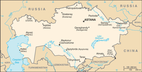
::阿富汗通常也被列为中亚的一部分,尽管它从未正式成为苏联的一部分。Map of Kazakhstan
::哈萨克斯坦地图Kazakhstan
::哈萨克斯坦 哈萨克斯坦 哈萨克斯坦
The traditional people of Kazakhstan, who share a Mongol and Turkic heritage, moved into the Central Asia region some time after 1200 C.E. The expansion of the Russian Empire under the tsars integrated Kazakhstan and its neighbors, which eased their transition when the tsarist system of Russian government gave way to the Soviet Union. The influx of Russian people and culture had a major influence on Kazakhstan.
::哈萨克斯坦传统人民拥有蒙古和突厥的遗产,在公元1200年之后一段时间,哈萨克斯坦传统人民迁入中亚地区。 沙皇统治下的俄罗斯帝国扩张将哈萨克斯坦及其邻国融为一体,当俄罗斯政府沙皇制度让位于苏联时,这种扩张缓解了他们的过渡。 俄罗斯人民和文化的涌入对哈萨克斯坦产生了重大影响。The Aral Sea is decreasing in volume because of water being diverted from the two rivers to be used for irrigation of desert lands to grow enormous crops of grains and cotton.
::咸海水量正在减少,因为两条河流的水被挪用,用于灌溉沙漠土地,种植巨大的谷物和棉花作物。Kazakhstan gained independence from the Soviet Union in 1991, thereby creating the world’s largest landlocked nation. It is the ninth-largest state on the planet in terms of square miles and is larger in physical area than of all of Western Europe. This vast land is host to a wide variety of physical landscapes, including the high, snow-capped peaks of the ranges on the Chinese border. The western portions are lowlands bordering the Caspian Sea. The seemingly endless grasslands of the interior are one of the largest steppe regions in the world. The steppe region has a semiarid type B climate. A large portion of southern Kazakhstan is desert, including the northern regions of the Kyzyl Kum Desert. Colder type D climates are found in the northern regions of the country.
::哈萨克斯坦于1991年从苏联获得独立,从而创建了世界上最大的内陆国,以平方英里计,是全球第九大国家,其自然面积大于整个西欧。这块广阔的国土布满了各种各样的自然景观,包括中国边境的冰雪峰峰;西部是里海附近的低地;内地似乎无穷无尽的草原是世界上最大的草原地区之一。草原地区有半干旱的B型气候。哈萨克斯坦南部大部分是沙漠,包括Kyzyl Kum沙漠的北部地区。该国北部地区有较冷的D型气候。The steppe produces grain in large quantities and other agricultural products, while the productive mining of minerals adds to the national wealth. Kazakhstan ranks high in the mining of many metals and uranium. Even diamonds are found here. Oil and natural gas extraction accounts for the largest sector of the country’s economy and generates the largest export income. The Tengiz basin around the northeast shores of the Caspian Sea is home to extensive petroleum reserves. Oil pipelines are expanding to transport the oil to port locations and other countries, including China. The economy of Kazakhstan has been larger than the economies of all the other Central Asian states combined.
::草原生产大量谷物和其他农产品,而矿物的生产性开采增加了国家财富。哈萨克斯坦在许多金属和铀矿开采中名列前茅。这里甚至有钻石。石油和天然气开采是哈萨克斯坦经济中最大的部门,产生最大的出口收入。里海东北岸的Tengiz盆地拥有大量的石油储备。石油管道正在扩大,将石油运往港口地点和包括中国在内的其他国家。哈萨克斯坦的经济比其他中亚国家的经济总和还要大。Kazakhstan also has a forward capital. During the Soviet era, the capital was located in the southeast at Almaty. However, after gaining independence in 1991, the capital was moved north to Astana to ensure that the Russian-dominated northeast would be monitored against devolutionary forces wanting to secede and become part of the Russian Republic.
::哈萨克斯坦也有一个前方首都。 在苏联时代,首都位于阿拉木图东南部。 但是,在1991年获得独立后,首都被迁至阿斯塔纳北部,以确保俄罗斯控制的东北地区不受想要分离并成为俄罗斯联邦一部分的分权势力的监督。
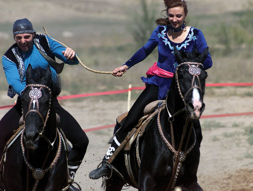
Kazakh performers demonstrate a cultural tradition of a game called “Catch a Girl,” in which the two riders (male and female) take off on horseback and try to catch each other. The female rider whips the male until she is caught. If the male catches the female, he is rewarded with a kiss.
::哈萨克表演者展示了一场叫“抓住女孩”的游戏的文化传统,在这场游戏中,两位骑手(男性和女性)骑着马下车并试图相互抓捕。 女骑手鞭打男性直到她被抓获。 如果男性抓住了女性,他会得到一个吻的奖励。Uzbekistan
::乌兹别克斯坦 乌兹别克斯坦 乌兹别克斯坦Map of Uzbekistan
::乌兹别克斯坦地图Uzbekistan physically borders all the Central Asian countries. It is the most populous Central Asian country with a population exceeding 27 million. Uzbekistan's eastern boundary extends deep into Kyrgyzstan territory. The boundary lines were created during the Soviet era to provide the central government with more control over its republics. Geographers call Uzbekistan a doubly landlocked nation because all of the countries that surround it are also landlocked. The main source of fresh water comes from the Eastern Highland regions. The main rivers have been heavily used for irrigation and are often depleted before reaching the Aral Sea.
::乌兹别克斯坦与所有中亚国家接壤,是人口最多的中亚国家,人口超过2 700万。乌兹别克斯坦的东部边界深入吉尔吉斯斯坦领土。边界线是苏联时代建立的,目的是向中央政府提供更多的对共和国的控制。地理学家将乌兹别克斯坦称为双重内陆国,因为周边国家都是内陆国。淡水的主要来源来自东部高原地区。主要河流大量用于灌溉,在到达咸海之前往往耗尽。Cotton is the main agricultural crop. Uzbekistan is one of the top producers of cotton in the world and is a major exporter to world markets. The central and western regions have mainly arid desert climates and rely heavily on the fresh water flowing in from the mountains. Agriculture employs a full one-fourth of the population and accounts for one-fourth of the gross domestic product (GDP). The extraction of gold, minerals, and fossil fuels are also prime economic activities. The country has been transitioning from the old Soviet Union’s command economy to a market economy competing in a global marketplace.
::主要农作物是棉花。 乌兹别克斯坦是世界上棉花产量最高的国家之一,也是世界市场的主要出口国。 中部和西部地区主要干旱的沙漠气候,严重依赖从山区流进的淡水。 农业雇用了全部四分之一的人口,占国内生产总值的四分之一。 黄金、矿物和化石燃料的开采也是主要经济活动。 乌兹别克斯坦一直从旧的苏联指挥经济向在全球市场上竞争的市场经济过渡。Uzbekistan is a country of young people. About one-third of the population is under the age of 15. Education was heavily emphasized during the Soviet era. As a result, about 99 percent of the population is literate, although about one-third of the people still live in poverty. Islam emerged in this country after Uzbekistan won its independence in 1991 after the fall of the Soviet Union. In a culture of openness, Islam has risen in prominence to the point that approximately 88 percent of Uzbeks profess Islamic beliefs. The most commonly spoken language is Persian/Farsi.
::乌兹别克斯坦是一个青年国家,大约三分之一的人口年龄在15岁以下,苏维埃时代,教育受到大力强调,因此,约99%的人口识字,尽管大约三分之一的人口仍然生活在贫困之中。在1991年乌兹别克斯坦在苏联垮台后获得独立后,伊斯兰教在乌兹别克斯坦出现。在开放文化中,伊斯兰教的突出程度上升到大约88%的乌兹别克人信奉伊斯兰信仰。最常用的语言是波斯语/法西语。Samarkand and the country’s capital city, Tashkent, are located in the eastern core region, which is home to most of the population. Tashkent has an unofficial population of more than three million people. The city, which sits on the confluence of a local river and its tributaries, started as an oasis for trade along the Silk Road. Samarkand is Uzbekistan’s second-largest city and is most noted as the central city of the Silk Road as well as an important historical city for Islamic scholars.
::撒马尔罕和乌兹别克斯坦首都塔什干都位于东部核心地区 — — 大部分人口都居住在该地。 塔什干有300多万非官方人口。 该市位于一条当地河流及其支流交汇处,开始在丝绸之路沿线作为贸易绿洲。 撒马尔罕是乌兹别克斯坦第二大城市,最著名的是丝绸之路中心城市,也是伊斯兰学者的重要历史城市。In 2001, UNESCO declared this 2,750-year-old city a . It is one of the oldest continually inhabited cities in the world and has been one of the more important cities in Central Asia. The historical architecture is heavily influenced by Islamic styles from Iran. The region around Bukhara, Uzbekistan’s 5th-largest city, has been occupied for at least the last 5,000 years. Bukhara was another important city on the Silk Road and is known for its Asian carpet and textile industry. This region has been an important cultural, economic, and scholarly center for most of its known existence.
::2001年,教科文组织宣布这座2 750岁的城市为......它是世界上最古老的不断有人居住的城市之一,也是中亚更重要的城市之一。 历史建筑受到伊朗伊斯兰风格的严重影响。 乌兹别克斯坦第五大城市布哈拉周边地区至少已经占领了5000年。 布哈拉是丝绸之路上的另一个重要城市,以亚洲地毯和纺织业著称。 该地区是大部分已知存在的重要文化、经济和学术中心。
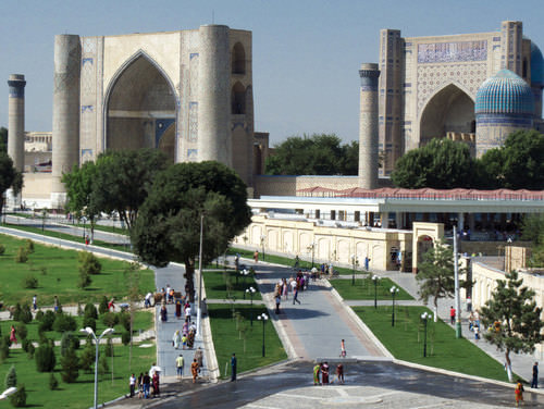
Samarkand, called the crossroads of culture, is located on the ancient Silk Road to China. The city is a UNESCO World Heritage Site.
::撒马尔罕被称为文化的十字路口,位于通往中国的古老丝绸之路上,是教科文组织的世界遗产所在地。The Aral Sea Environmental Disaster
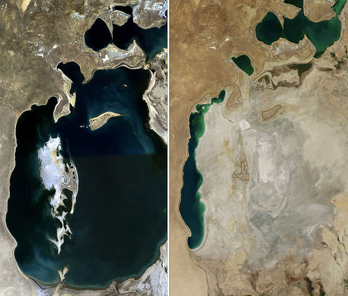
::咸海环境灾害Central Asia’s shrinking Aral Sea is shared by Uzbekistan and Kazakhstan. The sea was once the 4th-largest body of water in the world, but it has been reduced to a fraction of its original area. In 1960, the Aral Sea covered about 26,254 square miles, an area larger than the size of the US state of West Virginia. By 2009, the sea covered less than 10 percent of the same area. The entire eastern portion of the sea has become a sand desert, complete with the deteriorating hulls of abandoned fishing vessels. The loss of water is approximately equivalent to the complete draining of both Lake Erie and Lake Ontario in North America.
::中亚日益缩小的咸海由乌兹别克斯坦和哈萨克斯坦共同拥有。 海洋曾经是世界第四大水域,但已经缩小到最初面积的一小部分。 1960年,咸海覆盖了约26,254平方英里,面积大于美国西弗吉尼亚州的面积。 到2009年,海覆盖面积不到同一面积的10%。 整个东海变成了沙沙漠,随着废弃渔船船体的恶化,整个东海变成了沙沙漠。 水的流失与北美埃里湖和安大略湖的完全排水量差不多。The water loss escalated when the Syr Darya River, which flowed into the northern part of the sea, and the Amu Darya River, which flowed into the southern side of the sea, were diverted for the irrigation of cotton and other crops. At about 1,500 miles long, the Amu Darya is the region’s longest river. Its source is the high mountain streams and lakes of the Pamir Mountains. Environmental problems were further exacerbated by the extensive use of pesticides and fertilizers in agricultural processes. The chemicals contaminated the water flowing into the Aral Sea.
::流入海洋北部的Syr Darya河和流入海洋南部的Amu Darya河被转用于棉花和其他作物的灌溉,导致水的流失加剧,在大约1 500英里长的阿穆 Darya河是该地区最长的河流,其来源是帕米尔山脉的高山流和湖泊,在农业过程中广泛使用杀虫剂和肥料使环境问题进一步恶化,化学品污染了流入咸海的水。Once the water dried up in the sea, the winds carried the buildup of chemicals and salt from the dry seabed over the land, causing serious health-related problems in the nearby human population. Cancer and respiratory illness rates continue to be higher than normal. Water and land pollution is a serious problem. Even the climate around the Aral Sea has changed gradually because of the loss of water from evaporation for precipitation, causing the climate to become warmer in the summer and colder in the winter.
::海水干涸后,风从陆地干燥的海床积聚了化学物质和盐,给附近的人口造成严重的健康问题,癌症和呼吸道疾病率继续高于正常水平,水和土地污染是一个严重问题,甚至咸海周围的气候也逐渐发生变化,因为降水蒸发导致水分流失,导致夏季气候变暖,冬季更寒冷。The decline of the Aral Sea has destroyed habitats and the local economy. The fishing industry, which employed more than 60,000 people, has been devastated. The remaining western portion of the sea has a rising salt content that is contributing to the decline of the fish population. Adding to the environmental devastation, the Soviets conducted biological weapons experiments on an island that was once in the middle of the Aral Sea.
::咸海的衰落破坏了生境和当地经济,雇用了6万多人的渔业受到破坏,其余的西海地区含盐量不断上升,导致鱼类人口减少,除了环境破坏外,苏联还在曾经处于咸海中部的一个岛屿上进行了生物武器试验。Hazardous wastes such as anthrax and toxic chemicals contaminated the land and found their way into the sea. Efforts have been made to improve the environmental damage of the contamination, but the damage has had a lasting impact. The sea has historically been an important environmental location for wildlife. It is located in a major flyway for migratory waterfowl in Central Asia and served as an important habitat.
::诸如炭疽和有毒化学品等有害废物污染了陆地并进入海洋,努力改善污染的环境损害,但损害产生了持久影响,海洋历来是野生动物的一个重要环境地点,位于中亚移徙水禽的主要飞道,是一个重要的生境。The deterioration of the Aral Sea and the destruction of habitat for waterfowl and other organisms is one of the world’s worst environmental catastrophes. The fact that the Aral Sea is located in a region that is not part of the core economic area of the global community has rendered it “out of sight and out of mind” by entities that could potentially provide economic support.
::咸海的恶化以及水禽和其他生物栖息地的破坏是世界上最糟糕的环境灾难之一。 咸海位于一个不属于全球社会核心经济地区的地区,这一事实使那些可能提供经济支持的实体“目不转睛地”“失去理智地”地“失去理智地”地“失去理智地”地“失去理智地”地提供了经济支持。In the northern portion of the Aral Sea, called the Little Aral Sea, there has been some success in abating the deterioration of this once-thriving environmental habitat. A major dam has been constructed that partitions off the Little Aral Sea, causing water from the Syr Darya River to increase the water level of the Little Aral Sea and reduce the salt content. Canals, dikes, and irrigation processes have been updated to reduce the loss of water and increase the amount that flows into the northern section. These development efforts have resulted in the water level rising and have given the fishing industry new life. The efforts have been undertaken by Kazakhstan’s government, which controls the Little Aral Sea.
::咸海北部被称为小咸海,在缓解这一一度恶化的环境生境恶化方面取得了一些成功。 建造了一座大坝,从小咸海隔离开来,导致锡尔达里亚河水位上升,盐含量下降。 运河、堤坝和灌溉流程已经更新,以减少水的流失,增加流向北部的水量。 这些开发努力已经导致水位上升,并给渔业带来了新的生命。 哈萨克斯坦政府控制了小咸海。
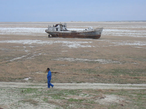
Orphaned ship in a dry seabed of the former Eastern region of the Aral Sea in Kazakhstan. The eastern half of the sea is completely dry.
::哈萨克斯坦前咸海东部地区干旱海底的孤儿船只,东半海完全干涸。
A major part of the southern portion of the once thriving sea is located in Uzbekistan. The remaining western portion of the Uzbekistan side of the Aral Sea will continue to shrink if measures are not taken to address the loss of water from the Amu Darya River. The eastern side was completely dry by 2009. Uzbekistan has responded to the situation by contracting out to various multinational oil companies from Korea, China, and Russia to explore for oil beneath the dry seabed.
::曾经繁荣的海洋的南部大部分位于乌兹别克斯坦,如果不采取措施解决阿姆河的缺水问题,咸海乌兹别克斯坦一侧的其余西部将继续缩小。 东部到2009年已经完全干涸。 乌兹别克斯坦已经通过向来自韩国、中国和俄罗斯的多家多国石油公司外包以勘探干海底的石油来应对这一局面。The demise of the Aral Sea was caused in part by the diversion of water from its northern inlet, the Syr Darya River. At the other end of the Syr Darya River an additional factor augmented the lack of water flow. The Soviet Union placed a dam on the river and allowed the overflow from the dam to flow into low-lying dry pans, creating artificial lakes. As a result, Aydar Lake was created and became the second-largest lake in Uzbekistan. Various species of fish were introduced and the lake became a major source for commercial fishing. Hundreds of tons of fish are harvested annually. Just as fishing was declining in the Aral Sea, the fishing industry was growing at Aydar Lake.
::咸海的消亡部分是由于咸海北部小口锡尔达里亚河的水被分流造成的,在锡尔达里亚河的另一端,又增加了一个因素,加剧了缺水的情况,苏联在河上建了一座水坝,使大坝的溢水流入低洼干锅,形成人工湖,因此,艾达尔湖被创造出来,成为乌兹别克斯坦第二大湖,引进了多种鱼类,湖成为商业捕鱼的主要来源,每年收获数百吨鱼类,正如咸海捕鱼量下降一样,艾达尔湖的捕鱼业也在增长。
These satellite images compare the Aral Sea between 1989 and 2008. The eastern region was completely dry by 2009, whereas the northern portion was responding favorably to Kazakhstan’s conservation efforts.
::这些卫星图象比较了1989年至2008年咸海,到2009年东部地区完全干涸,而北部地区对哈萨克斯坦的养护努力反应良好。Turkmenistan
::土库曼斯坦土库曼斯坦土库曼斯坦土库曼斯坦土库曼斯坦土库曼斯坦土库曼斯坦土库曼斯坦土库曼斯坦土库曼斯坦土库曼斯坦土库曼斯坦土库曼斯坦土库曼斯坦土库曼斯坦土库曼斯坦土库曼斯坦土库曼斯坦土库曼斯坦土库曼斯坦土库曼斯坦土库曼斯坦土库曼斯坦土库曼斯坦土库曼斯坦土库曼斯坦土库曼斯坦土库曼斯坦土库曼斯坦土库曼斯坦土库曼斯坦土库曼斯坦土库曼斯坦土库曼斯坦土库曼斯坦土库曼斯坦土库曼斯坦土库曼斯坦土库曼斯坦土库曼斯坦土库曼斯坦土库曼斯坦土库曼斯坦土库曼斯坦土库曼斯坦土库曼斯坦土库曼斯坦土库曼斯坦土库曼斯坦土库曼斯坦土库曼斯坦土库曼斯坦土库曼斯坦土库曼斯坦土库曼斯坦土库曼斯坦土库曼斯坦土库曼斯坦土库曼斯坦土库曼斯坦土库曼斯坦土库曼斯坦土库曼斯坦土库曼斯坦土库曼斯坦土库曼斯坦土库曼斯坦土库曼斯坦土库曼斯坦土库曼斯坦土库曼斯坦土库曼斯坦土库曼斯坦土库曼斯坦土库曼斯坦土库曼斯坦土库曼斯坦土库曼斯坦土库曼斯坦土库曼斯坦土库曼斯坦土库曼斯坦土库曼斯坦土库曼斯坦土库曼斯坦土库曼斯坦土库曼斯坦土库曼斯坦土库曼斯坦土库曼斯坦土库曼斯坦土库曼斯坦土库曼斯坦土库曼斯坦土库曼斯坦土库曼斯坦土库曼斯坦土库曼斯坦土库曼斯坦土库曼斯坦土库曼斯坦土库曼斯坦土库曼斯坦土库曼斯坦土库曼斯坦土库曼斯坦土库曼斯坦土库曼斯坦土库曼斯坦土库曼斯坦土库曼斯坦土库曼斯坦土库曼斯坦土库曼斯坦土库曼斯坦土库曼斯坦土库曼斯坦土库曼斯坦土库曼斯坦土库曼斯坦土库曼斯坦土库曼斯坦土库曼斯坦土库曼斯坦土库曼斯坦土库曼斯坦土库曼斯坦土库曼斯坦土库曼斯坦土库曼斯坦土库曼斯坦土库曼斯坦土库曼斯坦土库曼斯坦土库曼斯坦土库曼斯坦土库曼斯坦土库曼斯坦土库曼斯坦土库曼斯坦土库曼斯坦土库曼斯坦土库曼斯坦土库曼斯坦土库曼斯坦土库曼斯坦土库曼斯坦土库曼斯坦土库曼斯坦土库曼斯坦土库曼斯坦土库曼斯坦土库曼斯坦土库曼斯坦土库曼斯坦土库曼斯坦土库曼斯坦土库曼斯坦土库曼斯坦土库曼斯坦土库曼斯坦土库曼斯坦土库曼斯坦土库曼斯坦土库曼斯坦土库曼斯坦土库曼斯坦土库曼斯坦土库曼斯坦土库曼斯坦土库曼斯坦土库曼斯坦土库曼斯坦土库曼斯坦土库曼斯坦土库曼斯坦土库曼斯坦土库曼斯坦土库曼斯坦土库曼斯坦土库曼斯坦土库曼斯坦土库曼斯坦土库曼斯坦土库曼斯坦土库曼斯坦土库曼斯坦土库曼斯坦土库曼斯坦土库曼斯坦土库曼斯坦土库曼斯坦土库曼斯坦土库曼斯坦土库曼斯坦土库曼斯坦土库曼斯坦土库曼斯坦土库曼斯坦土库曼斯坦土库曼斯坦土库曼斯坦土库曼斯坦土库曼斯坦土库曼斯坦土库曼斯坦土库曼斯坦土库曼斯坦土库曼斯坦土库曼斯坦土库曼斯坦土库曼斯坦土库曼斯坦土库曼斯坦土库曼斯坦土库曼斯坦土库曼斯坦土库曼斯坦土库曼斯坦土库曼斯坦土库曼斯坦土库曼斯坦土库曼斯坦土库曼斯坦土库曼斯坦土库曼斯坦土库曼斯坦土库曼斯坦土库曼斯坦土库曼斯坦土库曼斯坦土库曼斯坦土库曼斯坦土库曼斯坦土库曼斯坦土库曼斯坦土库曼斯坦土库曼斯坦土库曼斯坦土库曼斯坦土库曼斯坦土库曼斯坦土库曼斯坦土库曼斯坦土库曼斯坦土库曼斯坦土库曼斯坦土库曼斯坦土库曼斯坦土库曼斯坦土库曼斯坦土库曼斯坦土库曼斯坦土库曼斯坦土库曼斯坦土库曼斯坦土库曼斯坦土库曼斯坦土库曼斯坦土库曼斯坦土库曼斯坦土库曼斯坦土库曼斯坦土库曼斯坦土库曼斯坦土库曼斯坦土库曼斯坦土库曼斯坦土库曼斯坦土库曼斯坦土库曼斯坦土库曼斯坦土库曼斯坦土库曼斯坦土库曼斯坦土库曼斯坦土库曼斯坦土库曼斯坦土库曼斯坦土库曼斯坦土库曼斯坦土库曼斯坦土库曼斯坦土库曼斯坦土库曼斯坦土库曼斯坦土库曼斯坦土库曼斯坦土库曼斯坦土库曼斯坦土库曼斯坦土库曼斯坦土库曼斯坦土库曼斯坦土库曼斯坦土库曼斯坦土库曼斯坦土库曼斯坦土库曼斯坦土库曼斯坦土库曼斯坦土库曼斯坦土库曼斯坦土库曼斯坦土库曼斯坦土库曼斯坦土库曼斯坦土库曼斯坦土库曼斯坦土库曼斯坦土库曼斯坦土库曼斯坦土库曼斯坦土库曼斯坦土库曼斯坦土库曼斯坦土库曼斯坦土库曼斯坦土库曼斯坦土库曼斯坦土库曼斯坦土库曼斯坦土库曼斯坦土库曼斯坦土库曼斯坦土库曼斯坦土库曼斯坦土库曼斯坦土库曼斯坦土库曼斯坦土库曼斯坦土库曼斯坦土库曼斯坦土库曼斯坦土库曼斯坦土库曼斯坦土库曼斯坦土库曼斯坦土库曼斯坦土库曼斯坦土库曼斯坦土库曼斯坦土库曼斯坦土库曼斯坦土库曼斯坦土库曼斯坦土库曼斯坦土库曼斯坦土库曼斯坦土库曼斯坦土库曼斯坦土库曼斯坦土库曼斯坦土库曼斯坦土库曼斯坦土库曼斯坦土库曼斯坦土库曼斯坦土库曼斯坦土库曼斯坦土库曼斯坦土库曼斯坦土库曼斯坦土库曼斯坦土库曼斯坦土库曼斯坦土库曼斯坦土库曼斯坦土库曼斯坦土库曼斯坦土库曼斯坦土库曼斯坦土库曼斯坦土库曼斯坦土库曼斯坦土库曼斯坦土库曼斯坦土库曼斯坦土库曼斯坦土库曼斯坦土库曼斯坦土库曼斯坦土库曼斯坦土库曼斯坦土库曼斯坦土库曼斯坦土库曼斯坦土库曼斯坦土库曼斯坦土库曼斯坦土库曼斯坦土库曼斯坦土库曼斯坦土库曼斯坦土库曼斯坦土库曼斯坦土库曼斯坦土库曼斯坦土库曼斯坦土库曼斯坦土库曼斯坦土库曼斯坦土库曼斯坦土库曼斯坦土库曼斯坦土库曼斯坦土库曼斯坦土库曼斯坦土库曼斯坦土库曼斯坦土库曼斯坦土库曼斯坦土库曼斯坦土库曼斯坦土库曼斯坦土库曼斯坦土库曼斯坦土库曼斯坦土库曼斯坦土库曼斯坦土库曼斯坦土库曼斯坦土库曼斯坦土库曼斯坦土库曼斯坦土库曼斯坦土库曼斯坦土库曼斯坦土库曼斯坦土库曼斯坦土库曼斯坦土库曼斯坦土库曼斯坦土库曼斯坦土库曼斯坦土库曼斯坦土库曼斯坦土库曼斯坦土库曼斯坦土库曼斯坦土库曼斯坦土库曼斯坦土库曼斯坦土库曼斯坦土库曼斯坦土库曼斯坦土库曼斯坦土库曼斯坦土库曼斯坦土库曼斯坦土库曼斯坦土库曼斯坦土库曼斯坦土库曼斯坦土库曼斯坦土库曼斯坦土库曼斯坦土库曼斯坦土库曼斯坦土库曼斯坦土库曼斯坦土库曼斯坦土库曼斯坦土库曼斯坦土库曼斯坦土库曼斯坦土库曼斯坦土库曼斯坦土库曼斯坦土库曼斯坦土库曼斯坦土库曼斯坦土库曼斯坦土库曼斯坦土库曼斯坦土库曼斯坦土库曼斯坦土库曼斯坦土库曼斯坦土库曼斯坦土库曼斯坦土库曼斯坦土库曼斯坦土库曼斯坦土库曼斯坦土库曼斯坦土库曼斯坦土库曼斯坦土库曼斯坦土库曼斯坦土库曼斯坦土库曼斯坦土库曼斯坦土库曼斯坦土库曼斯坦土库曼斯坦土库曼斯坦土库曼斯坦土库曼斯坦土库曼斯坦土库曼斯坦土库曼斯坦土库曼斯坦土库曼斯坦土库曼斯坦土库曼斯坦土库曼斯坦土库曼斯坦土库曼斯坦
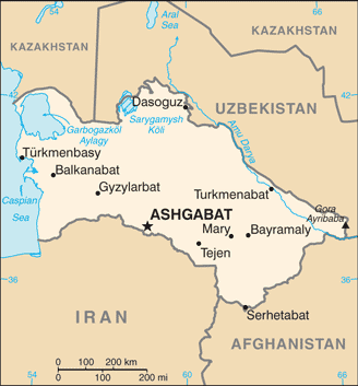
Map of Turkmenistan
::土库曼斯坦地图
To the south of the Amu Darya River is the desert country of Turkmenistan, which extends from the Caspian Sea to Afghanistan in the east. Turkmenistan is slightly larger in physical area than the US state of California. Roughly 80 percent of the country is covered by the Kara Kum Desert, which is among the driest in the world. The southern mountains along the Iranian and Afghan border reach as high as 10,290 feet in elevation. Water from the Amu Darya River has been diverted by the 700-mile-long Kara Kum Canal through Turkmenistan to help grow cotton and other agricultural products.
::阿穆达里亚河以南是土库曼斯坦的荒漠国家,从里海延伸到东部的阿富汗,土库曼斯坦的自然面积略高于美国加利福尼亚州,该国约80%的面积为世界上最干燥的卡拉库姆沙漠所覆盖,伊朗和阿富汗边界的南部山区高达10 290英尺,阿姆达里亚河的水被700英里长的卡拉库姆运河通过土库曼斯坦转运,以帮助种植棉花和其他农产品。The transition from a Soviet republic to an independent state in 1991 brought many changes. The former leader of the Turkmen Soviet Socialist Republic, Saparmurat Niyazov (also know as Turkmenbashi), was the president for 15 years. Through his authoritarian rule, he promoted a traditional culture with Islam as the predominant religion. He changed all the names of the days of the week and the months of the year to his name, the names of his family members, and the names of Turkmen heroes or famous people.
::1991年从苏维埃共和国向独立国家的过渡带来了许多变化,土库曼苏维埃社会主义共和国前领导人萨帕尔穆拉特·尼亚佐夫(也称为土库曼巴希)担任总统15年,通过独裁统治,他提倡传统文化,伊斯兰为主导宗教,将本周和本月份的所有日子和月份改名为他的名字、家庭成员的姓名、土库曼英雄或著名人物的名字。Turkmenbashi’s image was printed on the currency, and large posters of him could be seen throughout the country. His book on important concepts, the Ruhnama ( The Book of the Soul ), was to be read by all school children and the public. After his death in 2006, many of his actions were reversed. The country continues to transition to a stable democratic state, though many of the same dynamics of corruption and authoritarian rule remain.
::土库曼巴希的形象被印在货币上,他的大海报可以在全国各地看到。 他关于重要概念的书《鲁赫纳马书》(《灵魂之书 》 ) ( Ruhnama ) ( The Book of the Soul)将被所有学童和公众阅读。 2006年他去世后,他的许多行动被逆转了。 尽管腐败和专制统治的许多动力依然存在,但该国继续向稳定的民主国家过渡。Turkmenistan has the fourth largest natural gas reserves in the world. The income from natural gas exports has become the country’s greatest means of gaining wealth. Because Turkmenistan is landlocked, its government has been forced to partner with Russia to use of Russia’s pipelines to export the natural gas. Not wishing to rely on Russia’s monopoly on the pipelines, Turkmenistan developed an additional pipeline to China to help boost income and profits.
::土库曼斯坦拥有世界第四大天然气储量。 天然气出口收入已成为土库曼斯坦最大的财富获取手段。 由于土库曼斯坦是内陆国,土库曼斯坦政府被迫与俄罗斯合作利用俄罗斯的天然气管道出口天然气。 土库曼斯坦不想依赖俄罗斯对天然气管道的垄断,而是开发了一条通往中国的新增管道,以帮助增加收入和利润。Many international corporations are seeking to do business in Turkmenistan and Central Asia to corner a piece of the vast natural resources. Corporate colonialism is extremely active and has contributed to a high level of corruption in the government and the business sector. It is unclear how much of the country’s wealth filters down to most of the population. Over the past decade, unemployment rates have exceeded 50 percent, and more than half the population lives below the poverty line.
::许多国际公司正试图在土库曼斯坦和中亚做生意,以争夺一块巨大的自然资源。 公司殖民主义非常活跃,并助长了政府和企业部门的高度腐败。 目前还不清楚该国财富有多少被渗透到大多数人口身上。 过去十年来,失业率已经超过50%,超过一半的人口生活在贫困线以下。The administrative center and largest city of Turkmenistan is its capital, Ashgabat, which has a population of about one million. Ashgabat lies between the Kara Kum Desert and the mountains near the former Silk Road. In the historic region of Central Asia, it is comparatively a very young town, having grown out of a small village founded in 1818. Ashgabat is primarily a government and administrative center, although it has thriving cotton, textile, and metalworking industries. Ashgabat is also a popular stop along the Trans-Caspian Railway.
::土库曼斯坦行政中心及其最大的城市是首都阿什哈巴德,人口约100万,阿什哈巴德位于卡拉库姆沙漠和前丝绸之路附近的山丘之间,在中亚历史区域,阿什哈巴德相对是一个很小的城镇,从1818年成立的小村庄中发展出来,阿什哈巴德主要是一个政府和行政中心,尽管它有蓬勃的棉花、纺织和金属加工工业。 阿什哈巴德也是沿着跨开斯巴斯蒂安铁路的群众站。Kyrgyzstan
::吉尔吉斯斯坦吉尔吉斯斯坦吉尔吉斯斯坦
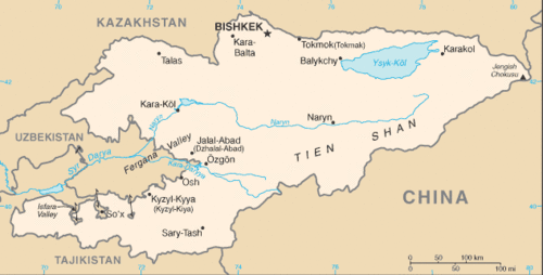
Map of Kyrgyzstan
::吉尔吉斯斯坦地图
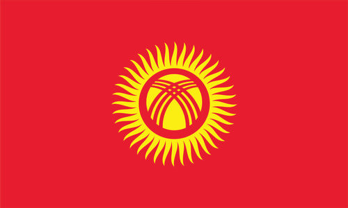
Local groups in the mountains of Central Asia make up the population of Kyrgyzstan. The 40 rays of sun on the country’s flag symbolize of the legendary 40 tribes of Manas that represent the nation. The rugged landscape of this mountainous land includes the high ranges of the Tian Shan Mountains, which can reach elevations as high as 24,400 feet and cover about 80 percent of the country. Snowfall from the mountains provides fresh water for agriculture as well as hydroelectric energy.
::中亚山区的当地群体构成吉尔吉斯斯坦的人口。 吉尔吉斯斯坦国旗上的40光阳光象征着代表国家的40个传奇的马纳斯部落。 这片山地的崎岖景观包括天山高地段,可达24,400英尺高地,覆盖全国约80%的面积。 山地降雪为农业提供了淡水,也为水电提供了能源。Food crops can be grown in the valleys and the few lowland areas. Half of the population works in agriculture, and self-sufficiency in food production is a major objective for survival. The mountains hold deposits of metals and minerals that have a strong potential for adding to the national wealth. Oil and natural gas reserves are also available for profit. The government is seeking foreign aid and investments to help develop these resources.
::谷地和少数低地地区可以种植粮食作物,半数人口务农,粮食生产自给自足是生存的一个主要目标,山区拥有金属和矿物矿藏,这些矿藏具有增加国家财富的巨大潜力,石油和天然气储量也可用于盈利,政府寻求外国援助和投资帮助开发这些资源。In 2009, Kyrgyzstan had a population of about 5.4 million in a land area about the size of the US state of South Dakota. About 30 percent of the population is under the age of 15, and about 36 percent of the population is urban. The western boundary with Uzbekistan and Tajikistan is winding and creates various small enclaves and exclaves of people from one country surrounded by people of another country and separated from their home nations.
::2009年,吉尔吉斯斯坦拥有约540万人口,面积相当于美国南达科他州。 约30%的人口不满15岁,约36%的人口为城市人口。 与乌兹别克斯坦和塔吉克斯坦接壤的西部边界正在收缩,并制造了由另一国人民包围并与其祖国分离的来自一国的小型飞地和聚居地。 2009年,吉尔吉斯斯坦拥有约540万人口,面积相当于美国南达科他州。 约30%的人口年龄在15岁以下,约36%的人口为城市人口。
The flag of Kyrgyzstan has a symbol of the sun and forty rays of light indicating the legendary forty tribes of Manas that represent the nation.
::吉尔吉斯斯坦的国旗象征着太阳和四十光线,
Kyrgyzstan’s transition from a Soviet republic to independence was not smooth. The loss of the state social safety net pushed the economy further to the informal sector, where trading and small transactions for personal survival are common. Shortages of consumer goods occur in rural areas and small towns. Kyrgyzstan is an isolated country that has been working to integrate itself into the global economy through technology and modernization. In 2010, clashes between Uzbeks and Kyrgyz brought about riots in the streets of major cities. These riots resulted in more than 200 casualties and 300,000 displaced citizens. After the situation cooled down, the government worked to stabilize itself with new leadership.
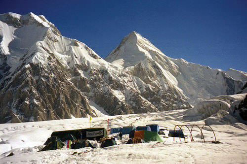
::吉尔吉斯斯坦从苏维埃共和国向独立过渡并非顺利。 国家社会安全网的丧失将经济推向了非正式部门,因为非正式部门为个人生存进行贸易和小规模交易是常见的。 消费品短缺发生在农村和小城镇。 吉尔吉斯斯坦是一个孤立的国家,一直致力于通过技术和现代化融入全球经济。 2010年,乌兹别克人和吉尔吉斯人之间的冲突在大城市的街头引发了骚乱。 这些骚乱导致200多人死亡和30万流离失所的公民。 局势平息后,政府努力通过新的领导力量稳定下来。Base camp on south Inylchek Glacier in the Tian Shan Mountains, Kyrgyzstan.The mountain in background is Khan Tengri (22,949 feet).
::基建在吉尔吉斯斯坦天山山南Inylchek冰川的营地。
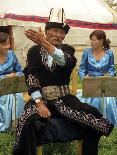
A form of improvisational oral poetry, which allegedly dates back to more than 1,000 years ago, is an aspect of traditional culture that has been preserved. While common throughout the region, it is mainly found in Kyrgyzstan and Kazakhstan. Practitioners will often engage in “lyrical battles” of folklore. These poets, often accompanied by two- or three-stringed instruments, will recite the Manas , an epic poem of Kyrgyzstan that details the life of the Kyrgyzstan hero Manas. This epic tale is a renowned part of the culture and festivals of Kyrgyzstan.
::一种即兴的口头诗歌形式,据称可追溯到1000多年前,是传统文化的一个保留面,虽然在吉尔吉斯斯坦和哈萨克斯坦地区很常见,但主要在吉尔吉斯斯坦和哈萨克斯坦。 开业者往往会参与民间传说中的“戏剧性战斗 ” 。 这些诗人通常配有两三根乐器,将朗诵《马纳斯》,这是吉尔吉斯斯坦的诗歌,详细介绍吉尔吉斯斯坦英雄马纳斯的生活。 这个史诗故事是吉尔吉斯斯坦文化和节日中著名的部分。A manaschi—a traditional storyteller—in Karakol, Kyrgyzstan, who has memorized entire epic legends of his history, recites the stories to others at a local festival.
::吉尔吉斯坦卡拉科勒的Manaschi——一个传统讲故事的人——在一次地方节日向其他人朗诵故事,他背诵了历史上的全部史诗传说。Tajikistan
::塔吉克斯坦 塔吉克斯坦Map of Tajikistan
::塔吉克斯坦地图
The eastern region of Central Asia has some of the highest mountain ranges in the world. About 90 percent of Tajikistan is mountainous, and more than half the country is 10,000 feet in elevation or higher. Ranges of the Himalayas extend from the south all the way to the western border with China. The Pamirs is a mountain range located where the Tian Shan, Karakorum, and Hindu Kush mountain ranges meet in Tajikistan, an area referred to as the Pamir Knot, or the roof of the world. Elevations in the Pamirs often exceed 24,500 feet.
::中亚东部地区拥有世界上最高的山脉,约90%的塔吉克斯坦是山区,超过一半的塔吉克斯坦高或高1万英尺,喜马拉雅山脉从南部一直延伸到与中国接壤的西部边界,帕米尔山脉是田山、卡拉科伦和兴都库什山脉在塔吉克斯坦(称为帕米尔克诺或世界屋顶的地区)相交的山脉,帕米尔山脉通常超过24 500英尺。The Pamirs is the source of the Amu Darya River and is home to the longest glacier outside the polar regions (48 miles long in 2009). There is great potential for hydroelectric power generation, and Tajikistan is developing the world’s highest dam.
::帕米尔河是阿姆河的源头,是极地地区以外最长的冰川(2009年为48英里长)的所在地(2009年为48英里长),水力发电潜力巨大,塔吉克斯坦正在开发世界上最高的水坝。Tajikistan has the smallest physical area of any country in Central Asia but has a population of about 7.3 million. Only about one-fourth of the population is urban, and one-third of the population is younger than 15 years of age. There is less ethnic or religious diversity. Approximately 80 percent of the people are ethnically Tajik and are Sunni Muslims. Though it has natural resources similar in quantity to those in Kyrgyzstan, Tajikistan’s economy is not advanced enough to fully take advantage of its economic potential. Half of the labor base works abroad and sends remittances back to their families for economic support. Unemployment is high, and job opportunities have not been able to keep up with demand.
::塔吉克斯坦的自然面积在中亚任何国家中都是最小的,但人口大约为730万。只有四分之一的人口是城市人口,三分之一的人口不到15岁。种族或宗教多样性较少。大约80%的人口是塔吉克人,是逊尼派穆斯林。尽管塔吉克斯坦拥有与吉尔吉斯斯坦相似的自然资源,但塔吉克斯坦经济不够发达,无法充分利用其经济潜力。一半的劳动力在国外工作,并将汇款汇回家人,以获得经济支持。失业率高,就业机会无法跟上需求。Dushanbe, the capital and largest city of Tajikistan, is situated on the confluence of two local rivers and is famous for its Monday markets. Dushanbe, like Ashgabat in Turkmenistan, was originally a small village. It became an administrative center for the region when the Soviet army conquered the area in 1929. Similar to many of the other cities and regions in Central Asia, the Soviets transformed the political and economic landscape and made Dushanbe a center for cotton and silk production. The Soviets also transformed the cultural and ethnic makeup of the city by relocating tens of thousands of people from Russia and other regions of Central Asia to Dushanbe.
::杜尚别是塔吉克斯坦首都和最大城市,位于两条当地河流汇合处,星期一市场出名。杜尚别与土库曼斯坦的阿什哈巴德一样,最初是一个小村庄,1929年苏维埃军队征服该地区时成为该地区的行政中心。与中亚其他许多城市和地区一样,苏维埃改变了政治和经济格局,使杜尚别成为棉花和丝绸生产中心。苏维埃还将数万人从俄罗斯和中亚其他地区迁移到杜尚别,从而改变了该城市的文化和族裔构成。The transition from the Soviet Republic to an independent country in 1991 was difficult for Tajikistan. From 1992 to 1997, a bitter civil war between regional factions killed more than 50,000 people. Political instability and corruption have hampered the growth of a market economy, and political power remains in the hands of the economic elite. Debt restructuring with Russia and development loans from China have aided the ailing economy. Aid from the US helped fund a 36-million-dollar bridge linking Tajikistan and Afghanistan, which opened in August 2007. US aid has also contributed to infrastructure development designed to help US military operations in Afghanistan and in the region as a whole. Countries such as Russia, China, and the United States are all looking to gain an advantage with their ties to Tajikistan to exploit the region’s natural resources.
::1991年从苏维埃共和国向独立国家的过渡对塔吉克斯坦来说是困难的。 从1992年到1997年,地区派别之间的激烈内战使5万多人丧生。政治不稳定和腐败阻碍了市场经济的增长,政治权力仍然掌握在经济精英手中。 与俄罗斯的债务重组和中国的发展贷款帮助了经济的停滞。 美国的援助帮助资助了一条连接塔吉克斯坦和阿富汗的3600万美元的桥梁,这条桥梁于2007年8月开通。 美国的援助也帮助了旨在帮助美国在阿富汗和整个地区的军事行动的基础设施建设。 俄罗斯、中国和美国都希望利用它们与塔吉克斯坦的关系来开发该地区的自然资源。Afghanistan
::阿富汗 阿富汗Present-day Afghanistan has been conquered by the likes of Genghis Khan, Alexander the Great, and the Mogul Empire. It was also a buffer zone for colonial feuds between Russia and British India. The high central mountain range of the Hindu Kush dominates the country and leaves a zone of well-watered fertile plains to the north and a dry desert region to the south. Afghanistan is a remote region without access to the sea and acts as a strategic link between the Middle East and the Far East.
::当今的阿富汗被成吉思汗、亚历山大大帝和莫古尔帝国等国家征服,也是俄罗斯和英属印度之间殖民纷争的缓冲区,兴都库什人高居中心山脉统治着这个国家,使北部有一个水源充足的肥沃平原地区,南部又有一个干燥的沙漠地区,阿富汗是一个偏远地区,没有出海口,是中东和远东之间的战略纽带。
Kabul is the capital, and the southern city of Kandahar is the 2nd-largest city.
::喀布尔是首都,南部城市坎大哈是第二大城市。The Soviet Invasion and the Taliban
::苏联入侵和塔利班In 1979, the Soviet Union took advantage of ongoing ethnic warfare in Afghanistan. The Soviets pushed in from the north and occupied much of Afghanistan until they completely withdrew in 1989. During the Soviet occupation, the United States supported anti-Communist resistance groups such as the Mujahideen with money, arms, and surface-to-air missiles. The missiles were instrumental in taking out Soviet aircraft and MiG fighters, which caused a critical shift in the balance of power in the war. One of the major connections between the Central Intelligence Agency (CIA) and Mujahideen was a Saudi national named Osama bin Laden. Support from the CIA through bin Laden to the Mujahideen was instrumental in defeating the Soviets.
::1979年,苏联利用阿富汗不断发生的种族战争,苏联从北方攻入并占领了阿富汗大部分地区,直到1989年完全撤出。在苏联占领期间,美国用金钱、武器和地对空导弹支持反共抵抗团体,如圣战者组织,如圣战者组织。导弹有助于击退苏联飞机和米格战斗机,导致战争权力平衡发生重大转变。中央情报局(CIA)和圣战者组织之间的主要联系之一是沙特国民乌萨马·本·拉丹。中央情报局通过本·拉丹支持圣战者组织有助于击败苏联。The power vacuum left by the retreating Soviets allowed conflicts to reemerge between the many ethnic factions in Afghanistan. Dozens of languages are spoken in Afghanistan. The top two are Pashtu and Afghan Persian-Dari. There are also a dozen major ethnic groups. The top two are Pashtun and Tajik. The groups regularly fight among themselves, but they have also been known to form alliances. Rural areas are usually led by clan leaders who are not part of any official arm of a national government. Afghanistan is a place where forming any national unity or identity is not easy. The national government in the capital city of Kabul has little influence in the country’s rural regions.
::后退的苏维埃留下的权力真空允许阿富汗许多种族派别之间重新爆发冲突。阿富汗使用数十种语言。前两个语言是普什图语和阿富汗波斯达里语。前两个语言是普什图语和阿富汗波斯达里语。还有十几个主要族裔群体。前两个群体是普什图语和塔吉克语。这两个群体经常相互争斗,但众所周知,它们也组成联盟。农村地区通常由不属于任何国家政府官方部门的部族领导人领导。阿富汗是一个不易形成国家统一或身份的地方。首都喀布尔的国家政府对该国农村地区的影响很小。The Soviet invasion united the warring factions for a short period of time to focus on the Soviet threat. Chaos and anarchy thrived after the Soviet forces withdrew, but the Islamic fundamentalist group known as the Taliban came forward to fill the power vacuum. One objective of the Taliban was to use Islam as a unifying force to bring the country together. The problem with that concept was that there was much diversity in how Islam was practiced by the numerous local groups.
::苏联的入侵在短短的时间内将交战各派联合起来,集中关注苏联的威胁。 苏联军队撤出后,混乱和无政府主义盛行,但被称为塔利班的伊斯兰原教旨主义团体挺身而出,填补了权力真空。 塔利班的一个目标是利用伊斯兰教作为团结力量,将国家团结在一起。 这一概念的问题是,许多地方团体对伊斯兰教的实践存在许多差异。Many of the factions in Afghanistan opposed the Taliban. One such group was the Northern Alliance, which was an association of groups located in the northern area of the country. The civil war between the Taliban and those that opposed them resulted in the deaths of more than 50,000 people by 1996, when the Taliban emerged to take power in Kabul. The Taliban is a Sunni Muslim group that adheres to strict Islamic laws under the Wahhabi branch of the faith similar to that of Saudi Arabia.
::阿富汗的许多派别都反对塔利班,其中之一是北方联盟,该联盟是由该国北部地区的团体组成的联盟,塔利班与反对派之间的内战在1996年塔利班开始在喀布尔掌权时造成50 000多人死亡,塔利班是一个逊尼派穆斯林团体,根据与沙特阿拉伯类似的瓦哈比宗教分支遵守严格的伊斯兰法律。Under Taliban rule, women were removed from positions in hospitals, schools, and work environments and had to wear burkas and be covered from head to toe, including a veil over their faces. Violators were either beaten or shot. The Taliban brought militant order to Kabul and the regions under their control. Various factions such as the Northern Alliance did not share the Taliban’s strict Islamic views and continued to oppose their position in power.
::在塔利班统治下,妇女被从医院、学校和工作环境中的岗位上撤走,不得不穿布勒卡式衣服,头部和脚趾都要蒙上头部,包括面罩;违法者要么被殴打,要么被射杀;塔利班向喀布尔及其控制的地区带来了好战秩序;北方联盟等各种派别不认同塔利班的严格伊斯兰观点,继续反对其当权地位。Al-Qaeda and the US Invasion
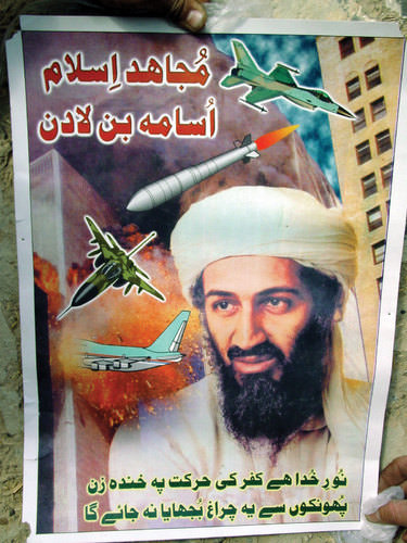
::" 基地 " 组织和美国的入侵After the war against the Soviet Union was over, the US role in Afghanistan diminished. The groups that the United States had supported continued to vie for power in local conflicts. Osama bin Laden remained in Afghanistan and established training camps for his version of an anti-Western resistance group called al-Qaeda. Just as he had opposed the Soviet Union, he now opposed the United States, even though the United States had supported him against the Soviets.
::在对苏联的战争结束后,美国在阿富汗的作用减弱了。 美国支持的集团继续在当地冲突中争夺权力。 乌萨马·本·拉丹仍然留在阿富汗,并为他所谓的反西方抵抗组织“基地组织”建立了训练营。 正如他反对苏联一样,他现在也反对美国,尽管美国支持他反对苏联。The Saudi government allowed the United States to establish military bases in Saudi Arabia during Operation Desert Storm in the Persian Gulf War. This was one reason for bin Laden’s opposition. He believed that non-Muslims should not be on the same ground as the Muslim holy sites of Mecca and Medina.
::沙特政府允许美国在波斯湾战争沙漠风暴行动期间在沙特阿拉伯建立军事基地。 这是本·拉丹反对的原因之一。 他认为非穆斯林不应该与穆斯林圣地麦加和麦地那在同一地点。The 9/11 attack in New York City was traced back to al-Qaeda and bin Laden, the latter whom was living in Afghanistan at the time. In a military action called Operation Enduring Freedom, the United States invaded Afghanistan in 2001, removed the Taliban from power, and dismantled the al-Qaeda training camps. Although bin Laden escaped, the terror of the Taliban was temporarily reduced. Women were allowed to return to the workplace, and the rebuilding of the country became a priority.
::纽约市发生的9/11袭击事件可追溯到基地组织和本·拉丹,后者当时居住在阿富汗。 2001年,美国入侵阿富汗,将塔利班从政权手中夺去,并拆除了基地组织训练营。 尽管本·拉丹逃脱,塔利班的恐怖却暂时减少。 允许妇女返回工作岗位,重建国家成为优先事项。The country was devastated by war and divided because of the various ethnic and traditional groups. Afghanistan is one of the most impoverished places on Earth. The armed conflicts in Afghanistan did not end with the US invasion. After regrouping, the Taliban rallied its supporters on the Pakistani side of the border and returned to the fighting front in Afghanistan against the North Atlantic Treaty Organization (NATO) and US forces.
::阿富汗被战争摧毁,并由于各种种族和传统群体而分裂。 阿富汗是地球上最贫穷的地方之一。 阿富汗的武装冲突并没有随着美国的入侵而结束。 在重新集结后,塔利班集结了边境巴基斯坦一侧的支持者,回到阿富汗与北大西洋公约组织(北约)和美国军队的战线。Osama bin Laden was killed by US Navy Seals in 2011.
::2011年,乌萨马·本·拉丹被美国海军海豹杀害。
Fighting between Western forces and the Taliban in Afghanistan continued to provide the exiled bin Laden a platform to promote his al-Qaeda terrorist activities from his hiding place. Efforts to locate and marginalize bin Laden continued through to the US presidency of Barack Obama. In May of 2011, on orders from President Obama, a team of US Navy Seals was sent into the city of Abbottabad, Pakistan to a private compound where intelligence indicated that bin Laden was hiding. In the confrontation, the US Navy Seal team killed bin Laden. The entire operation was conducted without the awareness of the Pakistani government.
::西方军队和塔利班在阿富汗的战斗继续为流亡的本·拉丹提供一个平台,以促使其“基地”组织的恐怖活动远离其藏身之地。 寻找本·拉丹并将其边缘化的努力一直持续到美国总统奥巴马。 2011年5月,根据奥巴马总统的命令,一支美国海军海豹队被派往巴基斯坦阿博塔巴德市,那里的情报表明本·拉丹正在躲藏。 在对抗中,美国海军海豹队杀害了本·拉丹。 整个行动是在巴基斯坦政府不知情的情况下进行的。The country is the world’s largest producer of opium, a product extracted from a poppy plant seedpod. Heroin is also produced from the poppy plant. The expanding poppy cultivation, as well as a growing drug trade, may account for one-third of the country’s income. More than 80 percent of the heroin consumed in Europe is grown in Afghanistan. The drug trade has only multiplied the problems in this devastated country.
::阿富汗是世界上最大的鸦片生产国,鸦片是从罂粟植物种籽中提取出来的产品。 海洛因也是从罂粟植物中生产出来的。 罂粟种植的扩大以及毒品贸易的不断增长可能占该国收入的三分之一。 在欧洲消费的海洛因中,80%以上是在阿富汗种植的。 毒品贸易只是这个饱受蹂躏的国家的问题的倍增。Most of the country is ruled by warlords and clan leaders who have few resources other than tradition and custom. Afghanistan’s infrastructure has been destroyed through warfare, and its government is dependent on foreign aid. Without it, this country cannot recover to participate in the global economy. Central Asia has enormous oil and natural gas reserves, and the core economic regions of the world will continue their work to extract these resources for economic gain.
::阿富汗大部分地区由军阀和部族领袖统治,他们除了传统和习俗之外,资源很少。 阿富汗的基础设施被战争摧毁,政府依赖外国援助。 没有战争,这个国家就无法恢复参与全球经济。 中亚拥有巨大的石油和天然气储备,世界核心经济地区将继续为获取经济收益而开采这些资源。Operation Enduring Freedom
::持久自由行动The US Department of Defense issued an official statement on Afghanistan in 2008 (Source DoD 2008):
::美国国防部于2008年发表关于阿富汗的官方声明(来源:2008年DOD):In response to the events of September 11, 2001, the U.S. and its allies launched an invasion of Afghanistan to overthrow the Taliban regime and destroy the al-Qaeda terrorist network it supported. In the years since, the International Security Assistance Force, under NATO leadership, has taken charge of extensive provincial reconstruction and stabilization efforts, helping set the economic, political and security conditions for the growth of an effective, democratic national government in Afghanistan. As the lead member of the international coalition, the U.S. contributes troops to both the ISAF [International Security Assistance Force] mission and Operation Enduring Freedom, tasked with pursuing al-Qaeda throughout Afghanistan’s inhospitable border region with Pakistan.
::2001年9月11日事件后,美国及其盟国入侵阿富汗,以推翻塔利班政权并摧毁它所支持的基地组织恐怖网络。 自那时以来,国际安全援助部队在北约的领导下,承担了广泛的省级重建和稳定工作,帮助为阿富汗发展一个有效、民主的国家政府创造经济、政治和安全条件。 作为国际联盟的主要成员,美国向国际安全援助部队(国际安全援助部队)的任务和“持久自由行动”提供部队,负责在阿富汗与巴基斯坦接壤的恶劣边境地区追捕基地组织。The Western military troops aligned themselves with Afghan groups such as the Northern Alliance to defeat the Taliban and remove the al-Qaeda presence.
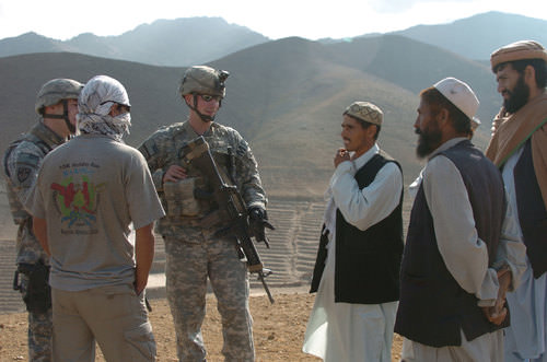
::西方军队与北方联盟等阿富汗团体结盟,以打败塔利班并消除基地组织的存在。Competing groups and the rough terrain make keeping the peace in Afghanistan difficult. The United States turned control over to NATO in 2006. In this photo, soldiers representing the 561st Military Police Company, Fort Campbell, Kentucky, are speaking with local Afghans about insurgent activity near Bagram, Afghanistan.
::相互竞争的团体和崎岖的地形使得维持阿富汗和平十分困难。 2006年,美国将控制权移交给北约(北约 ) 。 在这张照片中,代表561军警连、肯塔基州坎贝尔堡(Fort Campbell)的士兵与当地阿富汗人谈论阿富汗巴格拉姆附近的叛乱活动。
Democratic elections were held for the office of president in Afghanistan beginning in October of 2004. Hamid Karzai was the country’s first elected president in the 20th century. He was reelected as president in 2009 under claims of election fraud. The right to vote was restored to women in the 2004 election. To combat voter fraud, people would dip their fingers in ink to indicate that they did not vote more than once. Voting has not been a smooth process because democratic rule is new to Afghanistan.
::2004年10月开始在阿富汗举行总统竞选民主选举,哈米德·卡尔扎伊是阿富汗20世纪第一位当选总统。 2009年,他因选举舞弊而再次当选总统。 2004年选举中,妇女恢复了投票权。 为了打击选民欺诈,人们会用墨水来表示他们没有不止一次投票。 投票并不是一个顺利的过程,因为民主统治是阿富汗新事物。Afghanistan’s future is insecure. Most of Afghanistan is still ruled by warlords and clan leaders. The Taliban has sustained its support in Afghanistan from bases on the Pakistani side of the border, and the United Nations (UN) and NATO troops continue to confront the Taliban and work toward stability. Kandahar, the second-largest city in Afghanistan, is located in the south, an area where support for the Taliban is stronger than it is in Kabul in the north.
::阿富汗的未来是不安全的。 阿富汗大部分地区仍然由军阀和部族领导人统治。 塔利班一直从巴基斯坦边境一侧的基地支持阿富汗,联合国(UN)和北约部队继续对抗塔利班,并致力于稳定。 阿富汗第二大城市坎大哈位于南部,对塔利班的支持比北部喀布尔更为强大。After voting in Afghanistan, individuals dipped their fingers in ink to indicate they had voted and were not allowed to vote more than once. This photo indicates that women were also allowed to vote in Afghanistan in the 2005 elections for provincial councils and parliamentary positions.
::在阿富汗投票后,个人用墨水擦手指,表示他们已经投票,不允许投票不止一次,这张照片显示,在2005年阿富汗省议会和议会职位选举中,妇女也获准投票。Resources and Globalization
::资源与全球化In 2010, a US government report indicated that vast amounts of mineral wealth were discovered in Afghanistan by American geologists and Pentagon officials. Enormous deposits of iron, copper, gold, cobalt, and rare industrial minerals such as lithium are reported to be present in Afghanistan. Total reserves are unknown or have not been released but if extracted would result in trillions of dollars of economic gain for the country. Lithium is highly sought after and is used in the manufacturing of batteries, computers, and electronic devices. The report indicated that Afghanistan could become the world’s premier mining country.
::2010年,美国政府的一份报告指出,美国地质学家和五角大楼官员在阿富汗发现了大量的矿产财富。 据报道,在阿富汗有大量的铁、铜、黄金、钴和稀有工业矿物(如锂 ) 。 总储量未知或尚未释放,但如果开采将给阿富汗带来数万亿美元的经济收益。 锂被大量寻找,并被用于制造电池、计算机和电子设备。 报告表明阿富汗可以成为世界首屈一指的采矿国。In this photo is the Lataband Road between Kabul and Surobi. The dry, treeless expanse of this region is home to Afghanistan’s vast mineral wealth.
::这张照片是喀布尔和苏罗比之间的拉塔班路。 该地区的干燥无树的广阔地区是阿富汗巨大矿产财富的所在地。
Discovery of vast resources helps place the war in Afghanistan in perspective with respect to global competition over the control of resources. It has been reported that China has already offered millions of dollars in incentive money to Afghan government officials to allow its country to mine copper. Bribery and corruption in the Afghan government is an obstacle to a stable political environment, but criminal activities are projected to persist and grow with the potential for additional mining wealth.
::据报告,中国已经向阿富汗政府官员提供数百万美元的奖金,以便让阿富汗开采铜矿。 阿富汗政府的贿赂和腐败是稳定政治环境的一个障碍,但犯罪活动预计会持续并增加,并有可能带来更多采矿财富。Afghanistan does not have a long-standing tradition of mining. Agriculture has been the main focus of economic activity for rural communities. A newfound potential for mineral wealth will change the future of Afghanistan. It will be interesting to track how Afghanistan adapts to and benefits from the discovery of previously unknown resources.
::阿富汗没有悠久的采矿传统,农业一直是农村社区经济活动的主要重点,矿产财富的新潜力将改变阿富汗的未来,跟踪阿富汗如何适应和受益于以前未知资源的发现将令人感兴趣。
Key Takeaways
::密钥外出-
Central Asia is a landlocked region that receives little rainfall.
::中亚是一个内陆地区,降雨量很少。 -
Two large desert regions are located at the region’s core.
::两个大沙漠区域位于该区域的核心。 -
Vast grasslands called steppes dominate the northern sector.
::北方地区以大片草原为主,称为草原。 -
High mountains to the east provide a border between Central Asia and China.
::东部高山是中亚和中国之间的边界。 -
Central Asia (a.k.a. Turkestan) has been dominated by the Soviet Union during the 20th century.
::中亚(a.k.a.Turkestan)在20世纪由苏联统治。 -
The transition to independence has challenged the region to adjust to changes in political and economic systems.
::向独立过渡使该区域面临调整以适应政治和经济制度变化的挑战。 -
The demise of the Aral Sea is being caused by the diversion of water from the two rivers flowing into the sea. A once-thriving fishing industry has been destroyed and environmental damage has been catastrophic.
::咸海的消亡是由流入海洋的两条河流的水被分流造成的,一度兴旺的捕鱼业被摧毁,环境破坏是灾难性的。 -
Armed conflicts in Afghanistan continue between Western military forces and the Taliban over the control of the country. Clan leaders are a main part of the political foundation of the country. The diversity and fragmentation of the country make it almost impossible to govern.
::在阿富汗,西方军队和塔利班之间继续发生武装冲突以控制国家,部族领导人是该国政治基础的主要部分,国家的多样性和分裂性使得该国几乎不可能执政。 -
Afghanistan is one of the poorest countries in the world based on data on standards of living. However, the country has one of the largest deposits of valuable minerals and ores in the world waiting to be extracted. The deposits are the target of multinational corporations around the globe.
::阿富汗是世界上以生活水平数据为基础的最贫穷国家之一,然而,该国是世界上等待开采的有价值矿物和矿石储量最多的国家之一,这些储量是全球多国公司的目标。 -
The following is a summary of trends in Central Asia: (1) Shift from the Soviet Union to independent states; (2) Rise in authoritarian governments and corruption; (3) Increase of cultural influence of Islamic institutions; (4) Global economic focus on extractive activities; (5) Increase in military activity over control of resources; (6) Decline in agriculture as an economic base; (7) Continued concern for environmental problems
::以下是中亚趋势概述1) 从苏联向独立国家转变;(2) 专制政府崛起和腐败;(3) 伊斯兰机构的文化影响增加;(4) 全球经济对采掘活动的侧重;(5) 军事活动对资源的控制增加;(6) 农业作为经济基础的下降;(7) 继续关注环境问题
Vocabulary Terms
::词汇术语术语Chapter 6.4 Central Asia
::第6.4章 中亚The Aral Sea
::咸海An inland sea in Central Asia fed by the Syr Darya and Amu Darya Rivers; it has been steadily shrinking
::Syr Darya河和Amu Darya河滋养的中亚内陆海;该河一直在不断缩小dryland farming
::旱地农耕Farming that relies on rainfall instead of irrigation
::依赖降雨而不是灌溉的农业irrigation
::灌溉灌溉The supply of water to land or crops to help growth, typically by means of channeling water from a river
::向土地或作物供水,以帮助增长,通常通过从河流中输送水landlocked
::内陆内陆地区Completely surrounded by land with no direct access to the ocean
::被无法直接进入海洋的土地完全包围nomads
::游牧民People w ho do not have a permanent home and w ho often move from place to place
::没有永久住所而且经常从地方到地方流动的人Taliban
::塔利班塔利班塔利班塔利班塔利班A radical Muslim group that rose to power in Afg h anistan in the mid-1990s
::1990年代中期在阿富汗上台的激进穆斯林团体Applying Knowledge
::应用知识Discussion and Study Questions
::讨论和研究问题-
Why is Central Asia often referred to as Turkestan? What does the suffix “stan” indicate?
::为什么中亚经常被称为突厥斯坦?后缀“斯坦”意味着什么? -
Which country in Central Asia has a forward capital and why?
::中亚哪个国家有前方资本,为什么? -
How is the Tengiz basin important to the global economy? Where is it located?
::坦吉兹盆地对全球经济如何重要?它在哪里? -
How have problems with the Aral Sea affected the people of the region?
::咸海问题对该地区人民产生了何种影响? -
What is attracting multinational corporations to Central Asia? How do corporations impact politics?
::吸引多国公司进入中亚的是什么?公司如何影响政治? -
What happened in Tajikistan after it received independence in 1991? How did this affect the country?
::塔吉克斯坦在1991年获得独立后发生了什么情况?这对该国有何影响? -
List at least five general trends that have been occurring in Central Asia since the collapse of the Soviet Union.
::列出自苏联解体以来中亚至少出现的五大总趋势。 -
Why did the CIA get involved in the 1980s war in Afghanistan? Who acted as a CIA contact?
::为什么中情局卷入八十年代的阿富汗战争? -
What role did the Taliban once have in Afghanistan’s government? Why were not they allies with Iran?
::塔利班曾经在阿富汗政府中扮演什么角色? 为什么他们不是伊朗的盟友? -
What are the main methods of gaining wealth in Afghanistan today? How might this change in the future?
::今天在阿富汗获得财富的主要方法是什么?这种变化将来会如何?
Real-World Geography Exercise
::现实世界地理演习Using , locate each one of the physical regions below. From the list, choose five and calculate the distance and how long it would take to travel by airplane from El Paso, Texas to the nearest airport of your chose location. Be prepared to share your answers.
::使用 , 确定下面每个物理区域的位置。 从列表中选择 5 个, 计算从得克萨斯州埃尔帕索到您所选择地点最近的机场的飞机飞行距离和需要多长时间。 准备分享您的答案 。-
Amu Darya River
::阿姆河 -
Aral Sea
::咸咸海 -
Aydar Lake
::艾达尔湖 -
Caspian Sea
::里里海 -
Hindu Kush
::兴都库什 -
Kandahar
::坎大哈 -
Kara Kum Canal
::卡拉库姆运河 -
Kara Kum Desert
::卡拉库姆沙漠 -
Karakorum Ranges
::卡拉库鲁姆山脉 -
Kyzyl Kum Desert
::Kyzyl Kum 沙漠 -
Little Aral Sea
::小咸海 -
Pamir Knot
::帕米尔 Knot -
Pamirs
::帕米尔 -
Samarkand
::撒马尔罕 -
Syr Darya River
::锡尔达里亚河 -
Tengiz basin
::登吉兹盆地
Mapping Exercise
::绘图绘制作业ESRI GEO Inquiry
::ESRI GEGO调查: Students will explore the impact of human activities on water resources throughout the world with online mapping software.Videos for Geography Enrichment
::地理丰富视频Helpful Websites for the Study of Geography
::地理研究有用网站is an encyclopedia funded by the Canadian government covering all branches of knowledge. Their scholarly collection includes interactive materials.
::该百科全书由加拿大政府资助,涵盖所有知识分支,其学术收藏包括交互式材料。provides information on the people, history, government, economy, energy, geography, communications, transportation, military, and transnational issues for the world's entities.
::向世界各实体提供关于人民、历史、政府、经济、能源、地理、通信、运输、军事和跨国问题的资料。is a US government website where you can find federal legislation, past and present, as well as information about the US legal system.
::是一个美国政府的网站,您可以在此找到过去和现在的联邦立法以及关于美国法律制度的信息。is a government agency website that provides current news, resources, topics of interest, information about drugs, careers in the DEA, and a tip hotline.
::是一个政府机构网站,提供最新消息、资源、感兴趣的话题、毒品信息、在缉毒局的职业以及一条小费热线。is the largest library in the world and provides manuscripts, files, information, pictures, and videos.
::图书馆是世界上最大的图书馆,提供手稿、文件、信息、图片和录像。is a US government agency website that allows users to search for and retrieve satellite images of Earth.
::这是一个美国政府机构的网站,用户可以搜索和检索地球的卫星图像。is a US government website that provides historical documents, photos, records, publications, and educator resources.
::这是一个美国政府网站,提供历史文件、照片、记录、出版物和教育资源。is a US government agency website that provides weather-related information and ocean research.
::是一个提供气象信息和海洋研究的美国政府机构网站。is a website by the United States Geological Survey and other federal, state, and local agencies that delivers topographic information for the United States.
::这是美国地质调查局和其他联邦、州和地方机构为美国提供地形信息的网站。is a massive central data source and a handy way to graphically compare nations.
::是一个庞大的中央数据源,是用图形比较国家的一种方便方式。is a website that measures most locations in the world for air pollution in real time.
::是一个实时测量世界上大多数空气污染地点的网站。is a unique statistical database, which allows you to research and compare a multitude of different data on US states.
::这是一个独特的统计数据库, 使你能够研究和比较关于美国各州的多种不同数据。is an international organization founded in 1945 and made up of 193 member states. The UN maintains international peace and security, protects human rights, delivers humanitarian aid, promotes sustainable development, and upholds international law.
::联合国是一个国际组织,成立于1945年,由193个成员国组成。 联合国维护国际和平与安全,保护人权,提供人道主义援助,促进可持续发展,维护国际法。is a US government agency that provides a population clock, data, surveys, statistics, a library with information and infographics, news about the economy, and much more.
::这是一个美国政府机构,它提供人口钟、数据、调查、统计、一个拥有信息和信息资料的图书馆、关于经济的新闻,以及更多。is a US government agency website that provides scientific information about the natural hazards that threaten lives, the natural resources we rely on, the health of our ecosystems and environment, and the impacts of climate and land-use change.
::这是一个美国政府机构的网站,提供科学信息,说明威胁生命的自然危害、我们赖以生存的自然资源、生态系统和环境的健康以及气候和土地使用变化的影响。is a US government website that provides the latest presidential news, information about the budget, policy, defense, and many more topics.
::提供最新总统新闻、预算、政策、国防等资讯, 以及更多议题。is under the United Nations and provides leadership on matters critical to health, shapes the research agenda on health, and monitors the health situation and assessing health trends around the world. Their website provides information on the state of health around the world, outbreaks, current health news, and more.
::网站提供世界各地卫生状况、疫情爆发、最新卫生新闻等信息。is an intergovernmental organization that regulates international trade. The website provides information on the history of the multilateral trading system, featured videos, news and events, trade topics, and more.
::该网站提供关于多边贸易体系历史的信息、视频、新闻和事件、贸易专题等等。 -
Understand that Central Asia is a landlocked region that receives little rainfall and has to rely on water from major rivers flowing from the mountains in the east.