2.2板块构造理论
章节大纲
-
Lesson Objectives
::经验教训目标- Describe what a plate is and how scientists can recognize its edges.
::描述一个板块是什么 科学家如何识别它的边缘
- Explain how the plates move by convection in the mantle.
::解释一下板块是如何通过对流在地皮上移动的。
- Describe the three types of plate boundaries and the features of each type of boundary.
::描述三种类型的板块边界和每种类型的边界的特征。
- Describe how plate tectonics processes lead to changes in Earth's surface features.
::描述板块构造过程如何导致地球表面特征的变化。
Lesson Vocabulary
::词汇表课程- continental rifting
::大陆裂裂
- convergent plate boundary
::汇合板板板的边界
- divergent plate boundary
::盘盘边界
- intraplate activity
::板内活动
- island arc
::岛屿弧
- plate
::盘式
- plate boundary
::平板板边界
- subduction
::下下调
- subduction zone
::下潜带
- transform fault
::变换断过错
- transform plate boundary
::变版板的边界
Introduction
::导言Have you ever looked closely at a globe? That continents look like a giant jig-saw puzzle. North America looks like it could fit next to Europe. The edge of South America matches Africa. Scientists noticed these same features. It caused them to start asking questions. They wanted to know if these continents were was connected? If so, how can something so large move so far? What could possibly have enough force to move such a giant slab of rock? Is there other evidence that can provide clues to the past positions of continents? How can answering these questions help us?
::你是否仔细看过一个地球?这些大陆看起来像一个巨大的拼图。北美看起来可以与欧洲相匹配。南美洲的边缘与非洲相匹配。科学家注意到了这些特征,他们开始问问题。他们想知道这些大陆是否有联系?如果有联系,那么这么大的东西怎么能够走这么远呢?有什么力量足以移动这样一个巨大的岩石板呢?还有什么其他证据能为大陆过去的位置提供线索?回答这些问题能帮助我们吗?A scientist named Alfred Wegener had these same questions. Wegener look at rocks on both sides of the Atlantic Ocean. He noticed they were the same type and age. He thought that the rocks must have formed side by side. He proposed that the rocks then drifted apart. One part went with North America. The other part stayed with Europe. .
::一个名叫Alfred Wegener的科学家也有同样的问题。 Wegener查看大西洋两岸的岩石。 他注意到这些岩石的类型和年代相同。 他认为岩石必须同时形成。 他提议岩石会漂浮。 一部分与北美有关,另一部分与欧洲有关。Wegener also matched up mountain ranges. The Appalachian Mountains were just like mountain ranges in other places across the Atlantic. They looked like mountains in eastern Greenland, Ireland, Great Britain, and Norway. Wegener thought they must have formed as a single mountain range. This mountain range must have broke apart as the continents split up. The mountain range separated as the continents drifted.
::维格纳(Wegener)也与山脉相匹配。 阿巴拉契亚山脉与大西洋其他地方的山脉相似。它们看起来像东格陵兰、爱尔兰、英国和挪威的山脉。维格纳认为它们必须形成为单一的山脉。随着大陆的分裂,这些山脉一定已经分裂了。随着大陆的漂移,山脉也分离了。Wegener's ideas are now well accepted in the science community. Science now knows a lot about this process that causes continents to move. The theory that explains how continents move is called plate tectonics. Plate tectonics is the key to many of Earth's mysteries. The theory of plate tectonics explains most of the features of Earth's surface. This knowledge helps us to know where and why mountains form. We know where new ocean floor will be created. We also know where it will be destroyed. We know why earthquakes and volcanic eruptions happen. More important, we know where they will happen. Having this knowledge also helps us find new mineral resources.
::Wegener 的想法现在在科学界被广泛接受。 科学现在对这一过程了解很多, 这一过程导致大陆移动。 解释大陆移动的理论被称为板块构造学。 板块构造学是地球许多神秘的关键。 板块构造学理论解释了地球表面的大部分特征。 这种知识帮助我们了解山岳的形成地点和原因。 我们知道新洋底的形成地点。 我们还知道它会在哪里被摧毁。 我们知道地震和火山爆发发生的原因。 更重要的是, 我们知道它们会在哪里发生。 有了这种知识,我们也能帮助我们找到新的矿物资源。Earth's Tectonic Plates
::地球的构造等离子So how did scientists learn so much about Earth? Believe it or not, it had to do with the Cold War. The military funded seismograph networks to be built. Seismographs measure the movement of Earth's surface. The purpose was to see if other nations were testing atomic bombs.
::科学家们是如何学到这么多地球的?信不信由你,这与冷战有关。军方资助的地震网络即将建立。地震测量测量地球表面的移动。目的是看看其他国家是否在试验原子弹。The seismographs were used to detect bomb tests. They also gave scientist detailed information about earthquakes around the world. What can earthquakes tell us about our planet?
::地震图用于探测炸弹试验,它们也向科学家提供有关世界各地地震的详细信息。地震能告诉我们地球的情况吗?Earthquake Locations
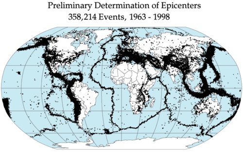
::地震地点The evidence about earthquakes was curious. Earthquakes did not happen everywhere. In some places they were common. In other places they were rare. They were very common along mid-ocean ridges. At the deep sea trenches they also happened frequently. In fact, earthquakes were common all around the Pacific Ocean. Volcanoes were also found in these same areas. Scientists named this region the Pacific Ring of Fire ( Figure ).
::地震的证据是令人好奇的。地震并非到处都发生。有些地方地震很常见。在另一些地方,地震是罕见的。在洋中脊上,地震非常常见。在深海战壕中,地震也经常发生。事实上,地震在太平洋各地都是常见的。在这些地区也发现了火山。科学家们把该地区命名为太平洋火圈(图 ) 。The Ring of Fire that circles the Pacific Ocean is where the most earthquakes and volcanic eruptions take place. Earthquakes and Plate Boundaries
::地震和板块边界Earthquakes seemed to outline a special feature of earth's crust. Earthquakes let scientists know where the crust was moving. This led to the discovery that Earth's crust was broken up into regions, or plates. Earthquakes happen most often along these plate boundaries ( Figure ). This was evidence that continents can move. The movements of the plates are called plate tectonics.
::地震似乎概括了地壳的特征。地震让科学家知道地壳的移动地点。这导致发现地壳被分割成区域或板块。地震最常在这些板块边界上发生(图 ) 。这是大陆可以移动的证据。板块的移动被称为板块构造。A map of earthquake epicenters shows that earthquakes are found primarily in lines that run up the edges of some continents, through the centers of some oceans, and in patches in some land areas. Earth's crust is divided into plates. There are about a dozen large plates and several small ones. Each plate is named for the continent or ocean basin it contains.
::地壳被分为板块,有十几个大板块和几个小板块,每个板块都按其所含大陆或海洋盆地命名。Scientists know he plates are in motion. They now know the direction and speed of this motion ( Figure ). Plates don't move very fast. They move only a few centimeters a year. This is about the same rate fingernails grow. So you might wonder, what could cause this motion? What supplies the energy to cause this change?
::科学家知道他的板块在运动中。 他们现在知道这个运动的方向和速度( 图表 ) 。 板块移动的速度并不快。 他们每年只移动几厘米。 这是指甲生长速度相同的问题。 所以, 您可能会怀疑, 是什么导致这个运动的? 是什么提供了这种变化的能量?Earth's plates are shown in different colors. Arrows show the direction the plate is moving. How Plates Move
::如何移动平台Heat supplies the energy that causes motion. The deeper you go into toward Earth's core, the hotter it gets. At the core it is really hot. All that heat tries to rise toward the surface. In the mantle, the rock is partially melted and is able to move. As it is heated, the material in the mantle moves toward the surface ( Figure ). As the mantle material rises, it cools. When it reaches Earth's crust, it is mostly stopped. A little of the material can break through the surface, but not all. Instead, it begins to move horizontally. The mantle material moves horizontally away from a mid-ocean ridge crest. Toward the surface, the mantle material starts to cool. As it cools it sinks back down into the mantle. These areas are where deep sea trench occur. The material sinks back down to the core. The system operates like a giant conveyor belt. The motion due to heating and cooling is called convection.
::热能提供引起运动的能量。 进入地球核心的深度越深, 温度越高, 它就会越热。 在核心, 热度就越高。 所有热量都试图向表面上升。 在表面, 岩石被部分熔化, 能够移动。 随着热度, 地壳中的物质会向表面移动( 图表 ) 。 当地壳物质升起时, 它会冷却。 当它到达地球的地壳时, 它大多停止了 。 有一点点物质可以穿透表面, 但不是全部。 相反, 它开始水平移动。 地壳材料会从洋中脊柱上水平移动开来。 地表上, 地壳材料开始冷却。 当它冷却时, 地壳物质会向地壳移动。 这些区域是深海沟发生的地方。 物质汇回到核心时, 系统会像一个巨大的传送带一样运作。 供暖气和冷却所需的运动被称为对流。Plates move for two reasons. Upwelling mantle at the mid-ocean ridge pushes plates outward. Cold lithosphere sinking into the mantle at a subduction zone pulls the rest of the plate down with it. Plate Boundaries
::热板边界Plate boundaries are where two plates meet. These are dynamic areas. Most geologic activity takes place at plate boundaries. As plates interact, they cause many of the large features we see on Earth's surface. As plates interact they can cause volcanoes, earthquakes. They can even cause mountain ranges to form. Plates can interact in different ways. Plates can move away from each other. They can move toward each other. Finally, they can slide past each other.
::板块边界是两个板块相交的地方。 这些是动态区域。 大多数地质活动都是在板块边界上进行的。 随着板块的相互作用, 它们产生了我们在地球表面看到的许多大特征。 随着板块相互作用, 它们可以引起火山和地震。 它们甚至可以造成山脉的形成。 板块可以以不同的方式相互作用。 板块可以相互移动。 它们可以相互移动。 最后, 它们可以滑过对方。These are the three types of plate boundaries:
::这些是三种类型的板块边界:- At divergent plate boundaries the two plates move away from each other.
::在不同的板块边界上,两个板块相互分开。
- At convergent plate boundaries the two plates move towards each other.
::在交汇的板块上,两块板块相互靠近。
- At transform plate boundaries the two plates slip past each other.
::在变形车牌上,两张车牌互相滑过对方。
The features created vary by the boundary type. They also vary by the type of crust at the boundary.
::所创造的特征因边界类型而异,也因边界的地壳类型而异。Divergent Plate Boundaries
::差异表边框Plates move apart at divergent plate boundaries. This can occur in the oceans or on land.
::在不同的板块边界上移动的等离子板。这可以在海洋或陆地上发生。Mid-ocean Ridges
::中洋海脊Plates move apart at mid-ocean ridges. As it gets pulled apart it gets thinner and thinner. Eventually, magma can break through. Lava rises upward, erupts, and cools. Lava is the name given to magma that has reached the surface. Over time, the layers of lava will push the seafloor outward. An example is how North America is moving away from Europe. There is a mid-ocean ridge in the center of the Atlantic Ocean.
::平流层在洋中脊移动。 当它被拉开时, 岩浆会变薄和变薄。 最后, 岩浆会破碎。 岩浆会向上上升, 喷发, 冷却。 岩浆是到达海面的岩浆的名称。 随着时间的推移, 岩浆层会将海底推向外部。 一个例子就是北美是如何从欧洲移走的。 大西洋中心有一个洋中脊。At these types of boundaries, new crust is formed. The rising of magma causes earthquakes. Most mid-ocean ridges are located deep under water. In a few areas the ridge is very tall. In a few places the ridge can be above water. The island of Iceland is one of those places. It is part of the Mid-Atlantic ridge ( Figure ). What makes the sea floor spread apart?
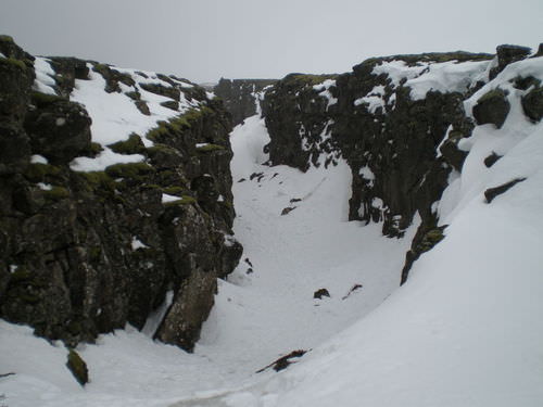
::在这些类型的边界上,形成了新的地壳。岩浆的上升造成了地震。大多数洋中脊位于水深处。在少数地区,海脊非常高。在少数地区,海脊可能位于水面之上。冰岛岛就是其中之一。它是中大西洋海脊的一部分(图 )。海底是什么使海床分散的?The rift valley in Iceland that is part of the Mid-Atlantic Ridge is seen in this photo. Continental Rifting
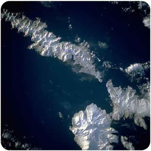
::大陆裂动A divergent plate boundary is not always beneath the ocean. Sometimes they occur on land. This is called continental rifting ( Figure ). Magma rises beneath the continent. The crust thins, breaks, and then splits apart. A valley is formed. These valleys are called "rift valleys." The East African Rift is a rift valley. Yes, Africa is breaking apart. Eastern Africa is splitting away from the rest of Africa. Eventually, the whole continental will break apart. The valley will get larger and larger. Magma will rise up. Lava will create a new surface. Has this ever happened before?
::不同的板块边界并不总是在海洋之下。 有时它们会发生在陆地上。 这被称为大陆裂痕(图 ) 。 岩浆会在大陆下上升。 地壳薄薄, 断裂, 然后分裂。 形成了一个山谷。 这些山谷被称为“ 裂谷 ” 。 东非裂谷是一个裂谷 。 是的, 非洲正在分裂 。 东部非洲正在脱离非洲其他地区 。 最终, 整个大陆将分裂 。 整个大陆将分裂 。 峡谷将变得越来越大。 岩浆将上升。 岩浆将创造新的地表。 这以前发生过吗 ?There was once a super continent called Pangaea. It broke apart just like Africa is doing now. This is how the Atlantic Ocean formed. It explains why North America and Europe could fit together.
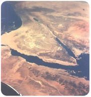
::曾经有一个叫潘加亚的超级大陆。它和现在的非洲一样分裂了。这就是大西洋形成的方式。它解释了为什么北美和欧洲可以融合在一起。The Arabian, Indian, and African plates are rifting apart, forming the Great Rift Valley in Africa. The Dead Sea fills the rift with seawater. Convergent Plate Boundaries
::一致的盘点边界Sometimes plates collide. These regions are called convergent plate boundaries. These collisions can happen anywhere. They can happen between a continent and oceanic crust. It can happen between two oceanic plates. It can even happen between two continents.
::有时板块碰撞。 这些区域被称为聚点板块边界。 这些碰撞可以在任何地方发生。 它们可以在大陆和大洋地壳之间发生。 它可以在两个海洋板块之间发生。 它甚至可以在两个大陆之间发生。Ocean-Continent Convergence
::大洋-大陆汇合What do you think will happen when plates collide? Oceanic crust may collide with a continent. The oceanic crust is denser than continental crust. As a result, oceanic crust subducts. Subduction occurs when on plate dives under the other during the collision. This occurs at an ocean trench ( Figure ). Subduction zones are where subduction takes place.
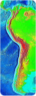
::当板块相撞时会发生什么?海洋地壳可能会与大陆相撞。大洋地壳比大陆地壳密度要高。因此,海洋地壳下水道会发生。在相撞期间,在板块下潜时会发生下潜。这发生在海沟(图 ) 。 俯冲区是进行俯冲的地方。These areas have intense earthquakes and volcanic eruptions. What happens to the subducted plate? It actually melts as it reenters the mantle. The magma it creates rises to the surface. It will eventually erupt onto the surface. This creates a volcanic mountain range. These occur near the coast of the continent. The Andes Mountains were formed along a subduction zone. The Andes Mountains run along the western edge of South America ( Figure ).
::这些区域有强烈的地震和火山爆发。 下层板块会怎样? 当它重新进入地壳时, 它会融化。 它产生的岩浆会升到地表, 最终会喷到地表上。 这会产生火山山脉。 这些山脉会发生在大陆海岸附近。 安第斯山脉是沿着下层地带形成的。 安第斯山脉会沿着南美洲西部边缘(图示 ) 运行。Subduction of an oceanic plate beneath a continental plate forms a line of volcanoes known as a continental arc and causes earthquakes. A relief map of South America shows the trench west of the continent. The Andes Mountains line the western edge of South America. Ocean-Ocean Convergence
::海洋海洋汇合What happens when two oceanic plates collide? One of the plates will sink beneath the other. The plate that subducts starts to melt as it is pushed deeper into the mantle. The melted rock works its way up toward the surface. It will eventually erupt onto the surface. It will form a volcano. Along the subduction zone a line of volcanoes will form ( Figure ). The volcanoes start to build new land. Japan, Indonesia, the Philippine Islands, and the Aleutian Islands of Alaska formed along subduction zones ( Figure ).
::当两个海洋板块相撞时会发生什么情况?一个板块会沉到另一个板块下方。 下水道的板块开始融化, 因为它被推入地壳的深处。 熔化的岩石会向地表倾斜, 最终会喷发到地表。 它会形成火山。 沿着潜入区, 火山将形成一条火山线( 图 ) 。 火山将开始建造新的土地。 日本、 印度尼西亚、 菲律宾群岛和阿拉斯加的阿利乌提群岛会沿着下沉带形成( 菲古尔 ) 。A convergent plate boundary subduction zone between two plates of oceanic lithosphere. Melting of the subducting plate causes volcanic activity and earthquakes. The Aleutian Islands that border southern Alaska are an island arc. In this winter image from space, the volcanoes are covered with snow. Continent-Continent Convergence
::大陆 -- -- 大陆汇合Continental crust is lighter than oceanic crust. It is also very thick compared to oceanic crust. Continental crust is too thick to subduct. When continental plates collide, they smash together. It's just like when put your hands on two sides of a sheet of paper and bring your hands together. The material has nowhere to go but up ( Figure )! This violent collision will cause many earthquakes. Unlike other types of collisions, volcanoes are not formed. The crust is too think for magma to get through.
::大陆地壳比大洋地壳轻。 与大洋地壳相比, 大陆地壳也非常厚。 大陆地壳太厚, 无法潜入。 当大陆板块相撞时, 它们会一起撞碎。 就像把你的手放在纸板的两侧, 并把你的手放在一块纸上一样。 材料无处可去, 只能举起( 图 ) ! 这种激烈的碰撞将引发许多地震 。 与其他类型的碰撞不同, 火山不会形成。 地壳太认为岩浆无法通过 。When two plates of continental crust collide, the material pushes upward, forming a high mountain range. The remnants of subducted oceanic crust remain beneath the continental convergence zone. Mountain Building
::山区山区建设In places where continents collide, very large mountain ranges are formed. You may know some of these mountain ranges. Have you ever hear of the Himalayas ( Figure )? They contain the world's tallest mountains. They are still getting higher. Every year they gain about an inch in height. They formed because two continents are colliding. The Indian plate is colliding with the Asian plate.
::在大陆相撞的地方,形成了巨大的山脉。你可能知道其中的一些山脉。你听说过喜马拉雅山脉吗?喜马拉雅山脉是全世界最高的山脉。它们仍然在上升。它们每年增加一英寸高。它们之所以形成,是因为两个大陆相互碰撞。印度板块与亚洲板块碰撞。The Appalachian Mountains formed this same way. The Appalachian Mountains formed a long time ago. They have been worn down through time. At one time they were taller than the Rocky Mountains. This range formed when two continents collided.
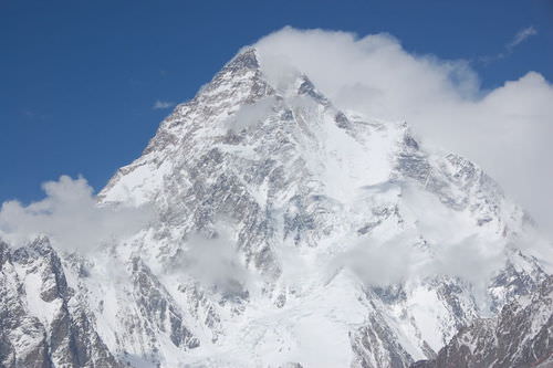
::阿巴拉契亚山脉也是这样形成的。 阿巴拉契亚山脉是很久以前形成的, 随着时间的推移, 这些山脉已经被磨损。 有一次, 它们比洛基山脉高。 当两个大陆相撞时, 这个山脉就形成了。The Karakoram Range is part of the Himalaya Mountains. K2, pictured here, is the second highest mountain the world at over 28,000 feet. The number and height of mountains is impressive. Transform Plate Boundaries
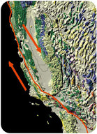
::变换板板边框In some places plates slide past each other. This is called a transform plate boundary. These plate boundaries experience huge earthquakes. You may have heard of the San Andreas Fault. It is a famous transform boundary. This fault runs through the State of California ( Figure ). At this fault, two plates slowly grin past each other. The Pacific plate is rotating counterclockwise. The North American plates is moving south. At transform plate boundaries, crust is not created nor destroyed.
::在有些地方,板块会互相滑过。 这叫做变形板块边界。 这些板块边界经历了巨大的地震。 您可能听说过圣安德烈亚斯断层。 这是一个著名的变形边界。 这个断层穿过加利福尼亚州( Figure ) 。 在这个断层上, 两个板块慢慢地互相微笑。 太平洋板块反时针旋转。 北美板块正在向南移动。 在变形板边界上, 地壳没有被创造或破坏 。The red line is the San Andreas Fault. On the left is the Pacific Plate, which is moving northeast. On the right is the North American Plate, which is moving southwest. The movement of the plates is relative to each other. Intraplate Activity
::内板活动Most geological activity takes place at plate boundaries. But some activity does not. Hot spots are location where the Earth is active. Hotspot volcanoes form as plumes of hot magma rise. These plumes of magma come from deep in the mantle.
::大多数地质活动是在板块边界进行的,但有些活动并非如此。热点是地球活跃的地方。热点火山是热岩浆上升的羽流。这些岩浆的羽流来自地壳深处。Hotspots in the Oceans
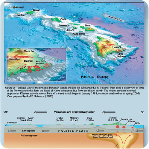
::海洋热点点A chain of volcanoes forms as an oceanic plate moves over a hot spot. This is how it happens. A volcano forms over the hotspot. Since the plate is moving, the volcano moves off of the hotspot. When the hotspot erupts again, a new volcano forms over it. This volcano is in line with the first. Over time, there is a line of volcanoes. The youngest is directly above the hot spot. The oldest is the furthest away ( Figure ).
::火山链形成时, 海洋板块在热点上移动。 情况就是这样。 火山在热点上形成。 自从热点上移动, 火山会从热点上移动。 当热点再次爆发时, 火山会形成新的火山。 这个火山与第一个火山线一致。 随着时间的推移, 火山线会一直存在。 最小的火山会直接在热点上方。 最老的火山离热点最远( 图示 ) 。This view of the Hawaiian islands shows the youngest islands in the southeast and the oldest in the northwest. Kilauea volcano, which makes up the southeastern side of the Big Island of Hawaii, is located above the Hawaiian hotspot. The Hawaiian Islands formed due to a Hotspot. The Kilauea volcano is still erupting. It is directly over the hotspot. Hotspots can tell us the speed and direction of plates.
::夏威夷群岛是由热点形成的。 Kilauea火山仍在喷发。 它直接在热点上空。 热点可以告诉我们板块的速度和方向。Hotspots Beneath Continents
::位于各大洲以下的热点点Yellowstone Lake lies at the center of a giant caldera. This hole in the ground was created by enormous eruptions at the Yellowstone hotspot. The hotspot lies beneath Yellowstone National Park. Hot spots are also found under the continental crust. Remember, continental crust is very think. It is more difficult for magma to make it through the thick crust. This makes them far less common. One exception is the Yellowstone hotspot ( Figure ). This hotspot is very active. In the past, the hotspot produced enormous volcanic eruptions. Now its activity is best seen in the region's famous geysers.
::在大陆地壳下也发现了热点。 记住, 大陆地壳是非常思考的。 岩浆很难通过厚厚的地壳进行。 这使得岩浆更加不那么常见。 黄石公园热点( Figure ) 是一个例外。 这个热点非常活跃。 过去, 热点引发了巨大的火山爆发。 现在, 其活动最好见于该地区著名的喷泉。Lesson Summary
::经验教训摘要- Convection in the mantle drives the movement of the plates. It is what causes the crust to move over the Earth's surface. New oceanic crust forms at the ridge. It pushes the older seafloor away. It causes it to move horizontally away from the ridge.
::地壳的对流会驱动板块的移动。 它正是导致地壳在地表上移动的原因。 新的海洋地壳在海脊形成, 将老海底推开, 使海脊水平向外移动 。
- Plates interact at three different types of plate boundaries. These three types are divergent, convergent and transform fault boundaries. This is where most of the Earth's geologic activity takes place.
::板块在三种不同的板块界限上相互作用。这三种类型是不同的、趋同的和改变断层界限的。这是地球大部分地质活动发生的地方。
- These processes acting over long periods of time. They are responsible for the geographic features we see today.
::这些进程长期运作,是我们今天所看到的地理特征的原因。
Lesson Review Questions
::经验回顾问题Recall
::回顾- Name the three types of plate boundaries? Which has volcanoes? Which has earthquakes? Which has mountain building?
::列出三种板块边界? 火山在哪里?地震在哪里? 山地建筑在哪里?
Apply Concepts
::应用概念- Describe convection. How does this work to create plate boundaries?
::描述对等。 这如何建立板块边界 ?
Think Critically
::仔细仔细思考- Make some generalizations about which types of plate boundaries have volcanoes and which have earthquakes. Could you look at a plate boundary and determine what geological activity there would be?
::简单概括一下哪些类型的板块边界有火山,哪些有地震。 你能看看板块边界,确定哪些地质活动会发生吗?
Points to Consider
::需要考虑的要点- On the map in Figure , the arrows show the directions that the plates are going. The Atlantic has a mid-ocean ridge, where seafloor spreading is taking place. The Pacific Ocean has many deep sea trenches, where subduction is taking place. What is the future of the Atlantic plate? What is the future of the Pacific plate?
::在图中的地图上,箭头显示板块的方向。大西洋有一个洋中脊,海底正在蔓延。太平洋有许多深海战壕,正在潜入。大西洋板块的未来是什么?太平洋板块的未来是什么?
- Using your hands and words, explain to someone how plate tectonics works. Be sure you describe how continents drift and how seafloor spreading provides a mechanism for continental movement.
::使用你的手和文字, 请向某人解释板块构造是如何工作的。 请务必描述大陆的漂移和海底的扩展如何为大陆移动提供机制 。
- Now that you know about plate tectonics, where do you think would be a safe place to live if you wanted to avoid volcanic eruptions and earthquakes?
::现在你知道板块构造了 如果你想避免火山爆发和地震 你觉得哪里是安全的地方?
- Describe what a plate is and how scientists can recognize its edges.