3.3 美国和加拿大地区(2天)
章节大纲
-
Chapter Challenges
::章次 挑战-
Name the key characteristics of the regions of the United States and Canada.
::列出美国和加拿大地区的主要特点。 -
Describe the patterns of population growth or decline for the various regions.
::描述各区域的人口增长或下降模式。 -
List which regions have significant minority groups and why.
::列出哪些区域有大量少数群体及其原因。 -
Explain the environmental and social costs to rapid growth in the West.
::解释西方快速增长的环境和社会代价。 -
Summarize how physical geography has contributed to economic activities.
::概述地理地理对经济活动的贡献。
Student Learning Objectives
::学生学习目标TEKS Regional Unit 03: The United States and Canada Chapter 3.3 Regions of the US and Canada
::TEKS区域单位03:美国和加拿大WG.1B describe the human and physical characteristics of the same regions at different periods of time to evaluate relationships between past events and current conditions
::WG.1B 描述不同时期同一区域的人类和物理特征,以评估过去事件与当前状况之间的关系WG.4A Explain how elevation, latitude, wind systems, ocean currents, position on a continent, and mountain barriers influence temperature, precipitation, and distribution of climate regions
::WG.4A 解释高海拔、纬度、风系统、洋流、大陆位置、山地屏障如何影响气候区域的温度、降水和分布WG.4C Explain the influence of climate on the distribution of biomes in different region
::WG.4C 解释气候对不同区域生物群落分布的影响WG.5A Analyze how the character of a place is related to its political, economic, social, and cultural elements
::WG.5A 分析一个地方的特征如何与其政治、经济、社会和文化因素相关WG.7D Examine the benefits and challenges of globalization, including connectivity, standard of living, pandemics, and loss of local culture
::7D工作组审查全球化的惠益和挑战,包括连通性、生活水平、流行病和当地文化的丧失WG.9A Identify physical and/or human factors such as climate, vegetation, language, trade networks, political units, river systems, and religion that constitute a region
::WG.9A 查明构成区域的气候、植被、语言、贸易网络、政治单位、河流系统和宗教等有形和/或人为因素WG.9B Describe different types of regions, including formal, functional, and perceptual regions
::WG.9B 描述不同类型的区域,包括正式、功能和概念区域WG.14C Analyze current events to infer the physical and human processes that lead to the formation of boundaries and other political divisions
::WG.14C 分析当前事件,以推断导致形成边界和其他政治分裂的物质和人类过程Regions of the United States and Canada
::美国和加拿大地区Main Regions of the United States
::美国主要地区Main regions of the United States and Canada
::美国和加拿大主要区域The Northeastern Core
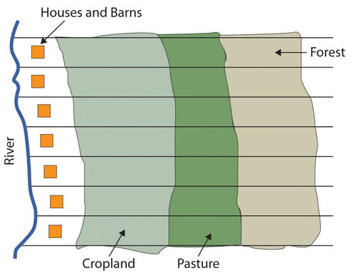
::东北核心The Northeastern Core includes the upper Midwest (Illinois, Indiana, Ohio, and Michigan); the mid-Atlantic states of Pennsylvania, New York, Maryland, and New Jersey plus northern Virginia; and the southern New England states of Connecticut, Rhode Island, and Massachusetts. It also includes southern Ontario, Canada’s capital (Ottawa), and its largest city (Toronto). The physical environments of the Northeastern Core are diverse, including the northern Gulf-Atlantic Coastal Plain, the northern Appalachians, and the area surrounding the Great Lakes.
::东北核心地区包括上中西部地区(伊利诺伊州、印第安纳州、俄亥俄州和密歇根州 ) ; 中大西洋州宾夕法尼亚州、纽约州、马里兰州、新泽西州加上北弗吉尼亚州;南新英格兰州康涅狄格州、罗德岛州和马萨诸塞州。 东北核心地区还包括加拿大首都(渥太华)的安大略省南部及其最大的城市(托龙多 ) 。 东北核心地区的自然环境多种多样,包括北海湾-大西洋沿岸平原、北阿巴拉契亚州以及大湖周边地区。This region, anchored by North America’s largest metropolis, New York, is the economic heart of the United States and Canada and home to more than a third of each country’s population. The megalopolis—the built-up area from Washington, D.C., to Boston—is part of this region. The core region contains the , which was once the main manufacturing region for North America, but suffered decline with the advent of the information age. The core region hosts the headquarters of countless corporations, banks, financial markets (e.g., ), universities, cultural institutions (e.g., , world-class museums, dance and music organizations), and even global organizations such as the .
::以北美最大的大都市纽约为根基的这个区域是美国和加拿大的经济中心,占每个国家人口的三分之一以上。 大都市地区 — — 从华盛顿特区到波士顿的建筑区 — — 是这个区域的一部分。 核心地区包含这个曾经是北美主要制造区,但随着信息时代的到来却在下降。 核心地区拥有无数的公司、银行、金融市场(例如 ) 、 大学、文化机构(例如,世界级博物馆、舞蹈和音乐组织),甚至全球组织(比如 ) 的总部。
Megalopolis
::梅加洛洛波利斯
Downtown Philadelphia’s city hall is an example of the urban qualities of the megalopolis that extends from Boston to Washington, DC.
::费城市中心市政厅就是从波士顿到华盛顿特区的特大城市城市质量的一个例子。
This large region includes geographic swaths of both wealth and poverty. Eight of the United States’ ten wealthiest counties are in this region, most of them in the Washington, D.C. area. Many billionaires live in New York City as well. Meanwhile, cities such as Detroit and Cleveland have suffered from deindustrialization and have experienced a major population decline since the 1950s. Detroit, for instance, has lost 61 percent of its population since 1950. Moreover, from 2000 to 2010, the city's population decreased by 25 percent.
::这个大地区包括财富和贫困的地理面积。 美国十个最富有的郡中有八个位于这个地区,其中大部分位于华盛顿特区地区。许多亿万富翁也居住在纽约市。 与此同时,底特律和克利夫兰等城市经历了非工业化,自1950年代以来人口大幅下降。 比如,底特律自1950年以来就失去了61%的人口。 此外,从2000年到2010年,该市的人口减少了25%。New England and the Canadian Maritimes
::新英格兰和加拿大海洋New England and the overlap with the Northeastern Core because its major city—Boston—is considered to be the northern edge of the megalopolis. South of Boston, the low-lying states of New England were the center of colonial settlement in the region and the birthplace of America’s Industrial Revolution. Southern New England began as an agricultural and fishing colony, and as the industry developed in the 19th century, the region attracted European immigrants to work in its factories.
::新英格兰及其与东北核心的重叠,因为其主要城市 — — 波士顿 — — 被认为是特大城市的北部边缘。 波士顿南部、新英格兰低洼州是该地区殖民定居的中心,也是美国工业革命的诞生地。 南新英格兰最初是一个农业和渔业殖民地,随着19世纪工业的发展,该地区吸引了欧洲移民到工厂工作。The highly skilled workforce helped maintain a strong economy in southern New England, although there have been times of increased unemployment and economic hardship. Today the region has a more diverse economic base, including recreation, tourism, finance, telecommunications, and healthcare. The mountains of western New England have been attractive for the development of ski resorts. The coasts of New England are popular destinations for summer vacations.
::高技能劳动力在新英格兰南部帮助维持了强大的经济,尽管失业和经济困难不断加剧,如今该地区经济基础更加多样化,包括娱乐、旅游、金融、电信和医疗保健。西新英格兰山脉对发展滑雪胜地具有吸引力。 新英格兰海岸是夏季度假的热门目的地。As you move north from Boston, the terrain becomes more rugged and the soil less fertile. There are fewer economic reasons for people to live in northern New England. The states of , , and have always been less populated than the southern New England states. Maine is the least populated state in this region. About 90 percent of its land is forested, making it the most forested of the United States. The vast Empty Quarter in western Maine consists of five million acres of privately owned forest and no permanent human inhabitants. Maine’s leading economic activity is manufacturing, and the bulk of it is oriented around paper and other wood products.
::随着你从波士顿向北移动,地形更加崎岖,土壤更贫瘠。人们在新英格兰北部生活的经济原因更少。新英格兰北部的州、州和人口一直比南英格兰州人口较少。 缅因州是该地区人口最少的州。 约90%的土地是森林,成为美国森林最多的地区。 缅因州西部巨大的空地有500万英亩私有森林,没有永久性居民。 缅因州的主要经济活动是制造业,大部分以纸张和其他木制品为主。Northern New England transitions to the even more rugged and remote uplands of the Canadian Maritimes: , , , . The soil quality is quite poor, as glaciers removed most of it during the various ice ages. The region has a harsh climate and is removed from the major population centers of Canada and the eastern United States.
::新英格兰北部向加拿大海洋地区更崎岖、更偏僻的高原过渡: , , , , , , 。 土壤质量相当差, 因为冰川在不同冰河时代将大部分土地移走。 该地区气候恶劣,从加拿大和美国东部的主要人口中心移走。In the Maritime Provinces, fishing and other sea-oriented businesses have historically been strong here. However, in recent decades overfishing of the North Atlantic has caused a decline in the fishing economy. Tourism has been increasing as a source of revenue, especially in places such as Prince Edward Island, in which tourism is the dominant economic activity. Newfoundland, including Labrador, is Canada’s poorest province.
::在海洋省,渔业和其他面向海洋的企业在历史上在这里一直很强劲。 但是,近几十年来,北大西洋过度捕捞导致了渔业经济的下降。 旅游业作为收入来源一直在增长,特别是在爱德华王子岛等以旅游业为主导经济活动的地方。 纽芬兰,包括拉布拉多,是加拿大最贫穷的省份。French Canada
::法属加拿大 加拿大West of the Canadian Maritimes lies the province of , the heart of which is the , a lowland separating the to the south from the inhospitable to the north. France was the first European country to colonize the coastal regions of what is now Canada, the St. Lawrence River Valley (most of the land surrounding the Great Lakes), and the Ohio and Mississippi River valleys, south to the Gulf of Mexico. Although Great Britain obtained all the land from France in 1763 following the , enough French inhabitants occupied part of the territory that the region did not automatically become English speaking.
::加拿大海洋的西部是加拿大的西部省,其中心是位于南边的低地,将南边与荒凉的北边隔开来,法国是第一个殖民现为加拿大的沿海地区、圣劳伦斯河谷(大湖周围大部分土地)以及俄亥俄河和密西西比河谷的欧洲国家,南至墨西哥湾,虽然英国在1763年从法国获得所有土地,但占领部分领土的法国居民已经足够,该地区不会自动成为英语国家。The core of French Canada today is the St. Lawrence Valley from to the Atlantic coast and west of Montreal to and north to the . These French speakers, the descendants of the early French settlers, created a vibrant French-Canadian culture. About 21 percent of Canadians speak French as their native language, including about 80 percent of Canadians living in the province of Quebec.
::今天,法属加拿大的核心是圣劳伦斯河谷,从大西洋沿岸到大西洋,从蒙特利尔以西到北到北。这些讲法语的人,即早期法国定居者的后裔,创造了充满活力的法裔加拿大文化。 大约21%的加拿大人讲法语,包括大约80%的加拿大人居住在魁北克省。Throughout most of its history, the people of Quebec have been rural farmers, making a living on mostly unproductive land in a place with a short growing season. One unique characteristic of the farms in French Canada is their size and shape. Early on, the farms were laid out as long lots, maximizing the number of farms that would have access to the transportation artery—usually a river, but sometimes a road.
::魁北克省人民在其大部分历史中一直是农民,在一个生长季节较短的地方以大部分非生产性土地为生。 法属加拿大农场的一个独特特征是其面积和形状。 早期,农场被铺设成长长的地块,使能够使用交通动脉的农场数量最大化 — — 通常是一条河流,但有时是一条道路。Each farm was about 10 times longer than it was wide and had a small access point to the river, some fertile riverfront land, and a woodlot at the rear of the farm. This land-use pattern was common throughout French Canada and can be seen today in the United States in former French colonies such as and .
::每个农场的长度大约是其宽度的10倍,并有一个小的河口入口、一些肥沃的河边土地以及农场后方的一个林地。 这种土地使用模式在法属加拿大各地很常见,今天在美国前法国殖民地,例如和......。
Long lot farms typical in French Canada.
::在法属加拿大典型的长片农场。
Since then, Quebec’s economy has developed to include a manufacturing sector (fueled by abundant hydroelectricity), tourism, and a variety of tertiary and quaternary industries. Montreal, Canada’s second-largest metropolitan area with , is the largest French-speaking city in the Western hemisphere. It developed as the region’s most important city in the mid-19th century, as it controlled access through the St. Lawrence River and the Great Lakes. It became a diverse industrial center, with oil refineries, steel mills, flour and sugar refineries, and shop yards for railroad companies.
::从那时起,魁北克的经济已经发展到包括制造业(由丰富的水电供应支撑 ) 、 旅游业以及各种第三产业和四产业。 加拿大第二大大都市地区蒙特利尔是西半球最大的法语城市。 魁北克在19世纪中叶发展成为该地区最重要的城市,控制着圣劳伦斯河和大湖的通路。 它成为一个多样化的工业中心,拥有炼油厂、钢铁厂、面粉和糖厂以及铁路公司的商店。Montreal attracted English speakers as well as the local French-speaking people. At times in its history, Montreal has had more English speakers than French speakers, despite being surrounded by a Francophone countryside. Most of northern Quebec is sparsely populated because of the lack of quality soil for agriculture. However, a paper and pulp industry based on its forests as well as the generation of hydroelectric power has developed over the 20th century.
::蒙特利尔吸引了讲英语的当地人和讲法语的当地人,在其历史上,蒙特利尔的讲英语者比讲法语者多,尽管周围是讲法语的农村,魁北克北部大部分人口稀少,因为缺乏高质量的农业用土,但是,20世纪发展了以森林为基础的纸和纸浆工业以及水力发电。The American South
::美国南部The South includes the entire southeastern portion of the United States from Kentucky south to Louisiana, east to Florida, and north to Virginia. The South consists of most of the Gulf-Atlantic Coastal Plain and the southern portion of the Appalachian Highlands. Before the Civil War, the coastal plain was dedicated to plantation agriculture using African slave labor.
::南方包括美国整个东南部地区,从肯塔基南部到路易斯安那,从东到佛罗里达,从北到弗吉尼亚。 南方包括大部分海湾-大西洋沿岸平原和阿巴拉契亚高原南部。 内战前,沿海平原用于种植农业,使用非洲奴隶劳动。Land not used for plantation crops such as tobacco, cotton, and rice was typically farmed by poor whites and later by poor blacks. Some were sharecroppers, while others farmed their own small plots, especially on the lesser-quality land in the Appalachia region. The South had little urbanization or industrialization at the time of the Civil War. Well into the 20th century, the region remained rural and economically deprived.
::不用于种植作物的土地,如烟草、棉花和稻米,通常由贫穷的白人耕种,后来又由贫穷的黑人耕种,有些是分享作物者,而另一些则是自己小块土地,特别是在阿帕拉契亚地区质量较低的土地上耕种,南方在内战期间几乎没有城市化或工业化,在20世纪,该区域仍然处于农村和经济贫困状态。Coal mining was a major source of employment in places such as and eastern Kentucky for the first two-thirds of the 20th century. Increased mechanization of mining methods, as well as new mining techniques such as mountaintop removal mining, decreased the number of minors needed, even as coal production increased.
::煤矿开采是20世纪前三分之二肯塔基东部和肯塔基东部等地的主要就业来源。 采矿方法的日益机械化以及新的采矿技术,如山顶采掘等,尽管煤炭生产增加,但减少了需要的未成年人数量。The Appalachian South has high unemployment, poverty, and difficult social conditions. Other areas of the rural South are amongst the poorest in the nation, including the Mississippi Delta and the lower Mississippi River valley. Despite the continued poverty in the South, parts of the region have prospered in the past generation. This is because northern migrants have moved to places such as Atlanta, Charlotte, Tampa, Miami, and many smaller cities in the south. This has fueled a period of urbanization and economic growth, and the newfound prosperity has helped the South move upward in the nation’s economy.
::阿巴拉契亚南部失业率高,贫困高,社会条件困难,南部农村地区是国家最贫穷的地区,包括密西西比三角洲和密西西比河下游河谷。 尽管南部贫困现象继续存在,但该地区部分地区在上一代人中已经繁荣。 这是因为北方移民迁到了亚特兰大、夏洛特、坦帕、迈阿密和南部许多小城市。 这助长了城市化和经济增长的时期,而新的繁荣帮助了南方向上发展。
Names often reflect the cultural region of their location. Business names with “Dixie” in them can be found throughout the South. The Dixie Grill restaurant is located in Morehead, Kentucky.
::地名往往反映其所在地的文化区域,在南方各地都可以找到“迪克西”的商号。 迪克西格里尔餐厅位于肯塔基州的莫赫德。The Midwest and Great Plains
::中西部和大平原The center of the continent contains a relatively level agricultural region: the Midwest and the Great Plains. This land includes some of the most fertile agricultural land in the entire world. This vast land is known as America’s breadbasket. The climate gets progressively more arid as you move to the west within this region, and the type of agriculture changes with the decrease in precipitation. Closer to the Rocky Mountains, the land is typically used for raising cattle. Grain farms are found where water is available, especially through irrigation.
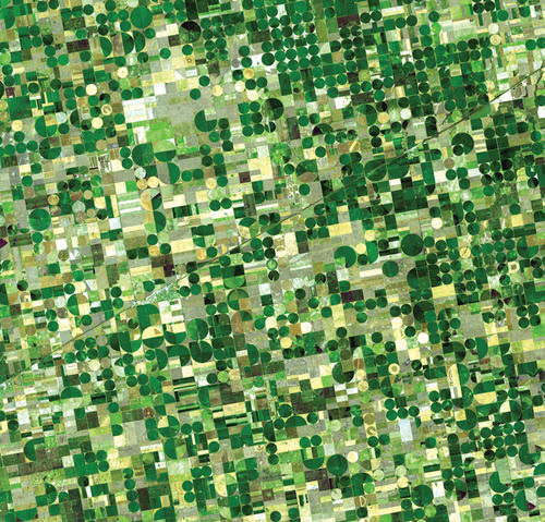
::非洲大陆中心包含相对较高的农业区域:中西部和大平原。这片土地包括了全世界一些最肥沃的农田。 这块大片土地被称为美国的面包篮。 气候随着地区向西移动而变得越来越干旱,随着降水量的减少,农业类型也随之发生变化。 靠近落基山脉,土地通常用于养牛。 谷物农场在水、特别是通过灌溉找到。The water for irrigation comes from the continent’s largest aquifer, the . Water is often pumped to the surface using a system called center pivot irrigation. The heart of the spring wheat belt is North Dakota, and the crop is also common in eastern Montana and in Canada’s Prairie Provinces of Alberta, Saskatchewan, and Manitoba. Winter wheat is common in Kansas and surrounding states. The corn belt is located farther to the east, mostly in Iowa and Illinois, where rainfall is more abundant.
::灌溉用水来自非洲大陆最大的地下蓄水层 — — 即 — — 。 水往往使用被称为中央支流灌溉系统抽到地表。 春季小麦带的核心是北达科塔(North Dakota ) , 丰田东部以及加拿大艾伯塔省、萨斯喀彻温省和马尼托巴省。 冬季小麦在堪萨斯州和周边各州很常见。 玉米带位于更远的东部,主要是爱荷华州和伊利诺伊州,那里降雨量更多。This map shows the extent of the Corn Belt.
::这个地图显示了玉米带的范围。The circular fields are between a half-mile and mile in diameter and are characteristic of fields that use center-pivot irrigation.
::这些圆形田的直径在半英里到英里之间,是使用中孔灌溉的田地的特征。
The dominant city in this region is Chicago, which developed as a market town for the livestock and grain produced in the surrounding states and was linked to its hinterland through a complex network of rail lines. In fact, nearly all the major cities of this region developed as places for the buying, selling, and processing agricultural products. Today the Midwest and the Great Plains remain the most important food-producing areas in North America, although as agriculture has become increasingly mechanized and farms have gotten larger, the number of farmers has decreased. This region, especially the Great Plains, is experiencing a period of long-term population decline and aging.
::该地区的主要城市是芝加哥,它发展成为周边各州生产的牲畜和谷物的市场城镇,并通过复杂的铁路网与内地连接起来。 事实上,该地区几乎所有主要城市都发展成为农产品的购买、销售和加工场所。 如今,中西部和大平原仍然是北美最重要的粮食生产区,尽管随着农业日益机械化和农场增加,农民的数量已经减少。 该地区,特别是大平原,正在经历长期人口下降和老龄化的时期。The American Southwest
::美国西南The states of Texas, New Mexico, and Arizona are considered the Southwest. The climate of the Southwest is more arid and receives a high amount of sunlight throughout the year. Desert conditions are integrated with higher elevations in the mountainous areas. Eastern Texas receives more rainfall from the . Western Texas and the states of New Mexico and Arizona are arid and receive less rainfall. These conditions are more favorable to cattle ranching than to other agricultural activities. Large farming operations exist where water is available for irrigation. The warmer climate has been attractive for development and people emigrating from the colder regions of the north.
::德克萨斯州、新墨西哥州和亚利桑那州被视为西南州,西南部的气候更干旱,全年阳光高,荒漠条件与山区高海拔相融合,东得克萨斯州从西得克萨斯州、新墨西哥州和亚利桑那州得到的降雨量更多,这些条件比其他农业活动更有利于牧牛,在有灌溉用水的地方存在大型农业作业,较温暖的气候对发展有吸引力,人们从北部较寒冷的地区迁移。
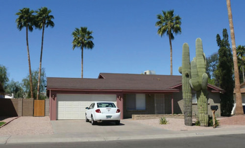
There is no grass to mow, and cactus and palm trees are common.
::没有草可以耕种,仙人掌和棕榈树是常见的。
The Southwest has a strong Hispanic heritage and was part of Spain’s Mexican colony before England established colonies on the East Coast. The first Spanish settlers arrived in New Mexico in 1598. All three states have a large population of Hispanic residents. Some of the families have been in these states before they became part of the United States, and others are recent immigrants. According to the United States Census Bureau, the Hispanic or Latino population in is 48.5 percent; in it is 39.1 percent; and, in , it is 30.9 percent.
::西南地区有着强大的西班牙裔遗产,在英国在东海岸建立殖民地之前,是西班牙墨西哥殖民地的一部分。 第一批西班牙定居者于1598年抵达新墨西哥。 这三个州都有大量西班牙裔居民。 其中一些家庭在成为美国的一部分之前就已经居住在这些州,而其他家庭则是最近移民。 根据美国人口普查局的数据,西班牙裔或拉美裔人口占48.5%;其中39.1%;而到30.9%。The Southwest also has a strong Native American presence, especially in New Mexico and Arizona. Twenty-one federally recognized tribes with more than 250,000 people (4.9 percent of the state’s population) live in Arizona. Their reservations and traditional communities make up more than one-fourth of the state’s land. The Navajo tribe is the largest in the United States, with more than 100,000 members in Arizona alone and others in surrounding states. The considerable Native American and Hispanic population in the Southwest means that non-Hispanic whites make up a minority of the population in New Mexico and Texas.
::西南地区也有强大的美洲原住民存在,特别是在新墨西哥州和亚利桑那州。 21个联邦承认的部落,人口超过25万(占州人口的4.9%),生活在亚利桑那州。 他们的保留地和传统社区占州土地的四分之一以上。 纳瓦霍部落是美国最大的部落,仅亚利桑那州就有超过10万成员,周边各州也有其他部落。 西南地区有大量美洲裔和西班牙裔土著人口,这意味着非西班牙裔白人占新墨西哥州和得克萨斯州人口的少数。
One of the Pollen Trail Dancers, a Navajo group near Joseph City, Arizona, performs the Eagle Dance on September 21, 2010, on the scenic South Rim of Grand Canyon National Park between Hopi House and Verkamp’s Visitor Center.
::2010年9月21日, 亚利桑那州Joseph市附近的纳瓦霍(Navajo)团体(Pollen Trail Dancer)在霍皮屋与Verkamp访客中心之间的大峡谷国家公园南风景中表演鹰舞。The three Southwestern states have been recipients of Sun Belt migrations over the past few decades, as people have moved to the Southwest for tertiary-sector jobs and for the region's warm climate. The region is urbanized, and most of the new migrants are moving to cities. Three-fourths of Arizona's population lives in the Phoenix or Tucson metropolitan area. The most populous metropolitan area in the Southwest is Dallas-Fort Worth-Arlington, Texas. According to a report released on March 22, 2018, by the , this area is the fastest growing metro area in the entire United States.
::近几十年来,西南三州一直接受太阳带移民,因为人们为了第三产业部门的工作和该地区温暖的气候而迁移到西南。这个地区已经城市化,大多数新移民正在迁移到城市。亚利桑那州四分之三的人口居住在凤凰城或图森大都市地区。西南人口最多的大都市地区是得克萨斯州达拉斯-福特沃斯-阿林顿。 根据2018年3月22日发布的一份报告,该地区是全美增长最快的地铁地区。The economy of Texas used to be based on oil and natural gas, but it has since become more diversified. Residents of these cities work in high-tech manufacturing, health care, business, and information. One of the most famous high-tech industries in Texas is space. Houston is home to the , where astronauts and thousands of others work in the space industry.
::得克萨斯州的经济过去以石油和天然气为基础,但后来变得更加多样化。 这些城市的居民在高科技制造、保健、商业和信息领域工作。 得克萨斯州最著名的高科技产业之一是空间。 休斯顿是航天工业的所在地,宇航员和其他数千名宇航员都在那里工作。The Mountain West
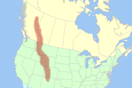
::山区西部From the Rocky Mountains to the Sierra Nevada, the Cascades, and Intermontane Basins and Plateaus in between, this part of North America has gone from the old Wild West to an area of rapid economic and population growth. The region encompasses western Colorado, western Wyoming, western Montana, Idaho, Nevada, Utah, the eastern portions of Washington, Oregon, and California, and the southern portion of the Canadian Rockies.
::从洛基山脉到内华达山脉、喀斯喀得山脉、蒙得纳河流域和高原之间,北美洲的这一地区已经从老的西部荒漠发展到一个经济和人口快速增长的地区。 该地区包括西科罗拉多、西怀俄明、西蒙大拿、伊达霍、内华达、犹他、华盛顿东部、俄勒冈和加利福尼亚,以及加拿大落基山脉的南部。
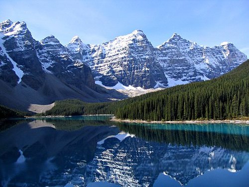
The Rocky Mountains are a major mountain range in western North America.
::洛基山脉是北美西部的一个主要山脉。
The Rocky Mountains formed 80 million to 55 million years ago.
::落基山脉在八千万到五千五百万年前形成
The population of the Mountain West is growing much faster than the population of the United States as a whole. For example, Nevada’s population grew 32.3 percent from 2000 to 2009, which is more than three times as much as the United States as a whole (9.1 percent). All US states in this region, except for Montana, grew at faster rates than the US average. Utah grew 24.7 percent, Idaho grew 19.5 percent, and Colorado grew 16.8 percent.
::山区西部的人口增长速度比美国整体人口增长速度快得多。 比如,内华达州的人口增长率从2000年到2009年是美国整体(9.1%)的三倍以上。 除蒙大拿州外,该地区所有美国州都以比美国平均水平更快的速度增长。 犹他州增长24.7%,爱达荷州增长19.5%,科罗拉多州增长16.8%。What is fueling this growth? It is part of the larger pattern of Americans flocking to the Sun Belt, searching for a better climate and lifestyle. Jobs have been created in recreation, in high-tech firms, and in other tertiary sector industries. Many of the migrants come from southern California because the housing in the Mountain West is more affordable and the region is much less crowded. Nearly all the growth is occurring in urban and suburban areas.
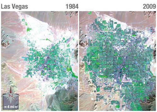
::这一增长的动力是什么?它是美国人聚集到太阳带寻找更好的气候和生活方式的更大模式的一部分。 在娱乐业、高科技公司和其他第三产业创造了就业机会。 许多移民来自南加利福尼亚州,因为西山地区的住房更负担得起,该地区人口更少。 几乎所有增长都发生在城市和郊区。However, the rapid growth of the West since 1990 has come at a cost. In some areas, the large population is putting a strain on physical resources, such as water. Water is a hot-button political issue, particularly in the more arid states such as Nevada. Las Vegas, for example, is a desert city that gets 90 percent of its water from Lake Mead, a Colorado River reservoir.
::然而,自1990年以来西方的快速增长已经付出了代价。 在一些地区,大量人口正在对水等物质资源造成压力。 水是一个热按钮政治问题,特别是在内华达等干旱程度较高的州。 比如,拉斯维加斯是一个沙漠城市,90%的水来自科罗拉多河水库Mead湖(一个科罗拉多河水库 ) 。This water comes from snowmelt in the Rocky Mountains far to the east, and due to drought and high water demand, Lake Mead’s water level has been dropping. If current patterns persist, Las Vegas will eventually have a water crisis. The water shortage is happening even though Las Vegas has managed to reduce per capita water usage by raising prices for water and creating incentives to remove grass lawns. Las Vegas recycles 94 percent of all sewage water, which is the highest rate in the United States.
::这一水来自远在东部的落基山脉的雪熔,由于干旱和高水需求,米德湖的水位一直在下降。 如果目前的模式持续下去,拉斯维加斯最终将面临水危机。 尽管拉斯维加斯已经通过提高水价和鼓励清除草坪来降低人均用水量,但水资源短缺仍在发生。 拉斯维加斯回收了94%的污水,这是美国最高的污水排放率。As the West’s population increased rapidly, the region’s urban areas became part of the real estate bubble of the early 2000s. Real estate prices grew and the housing industry built one residential subdivision after another in the suburbs surrounding cities such as Las Vegas, Denver, and Salt Lake City. However, in the late 2000s the real estate market collapsed in many parts of the country, and Western cities were hard hit. As of early 2011, three of the five states with the highest foreclosure rates were in this region (Nevada, Utah, and Idaho), and the others were bordering states (Arizona and California).
::随着西方人口的快速增长,该地区的城市地区成为了2000年代初期房地产泡沫的一部分。 房地产价格上升,住房产业在拉斯维加斯、丹佛和盐湖城等城市周围的郊区又兴建了一座住宅小区。 然而,在2000年代末期,国内许多地方的房地产市场崩溃,西方城市受到重创。 截至2011年初,5个取消赎回权率最高的州(内瓦达、乌塔和伊达霍)中有3个位于该地区,其他州与该州接壤(亚里索纳和加利福尼亚 ) 。
Notice the dark purple of city streets and the bright green of irrigated vegetation.
::注意城市街道的黑暗紫色 和绿绿绿的灌溉植被The Pacific Coast
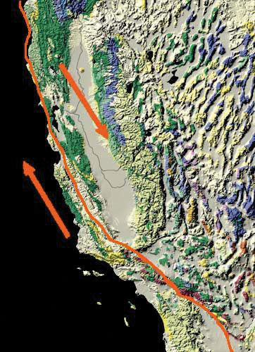
::太平洋海岸The Pacific Coast includes the coastal portions of California, Oregon, and Washington, plus the southwestern portion of British Columbia in Canada. This region is typically thought of as two subregions: California and the Pacific Northwest. The two areas are quite different from each other in terms of climate and economy. However, both areas are part of the that encircles the Pacific Ocean.
::太平洋海岸包括加利福尼亚州、俄勒冈州和华盛顿的沿海部分,加上加拿大不列颠哥伦比亚省西南部分。 该地区通常被视为两个次区域:加利福尼亚州和西北太平洋。 在气候和经济方面,这两个地区彼此差异很大。 但是,这两个地区都是环绕太平洋的一部分。The Ring of Fire is a zone of earthquakes and volcanic eruptions that occur near where the Pacific tectonic plate meets the surrounding plates. In the United States, two areas of concern are the San Andreas Fault in California and Mount St. Helens in Washington. The that destroyed San Francisco was a result of activity on the San Andreas Fault, and scientists predict that strong earthquakes will reappear along the fault in the future. Thousands of small earthquakes occur along the fault every year. is a volcano in the Cascades that erupted in 1980, killing 57 people and destroying hundreds of square miles of forest.
::火环是一个地震和火山爆发的地区,它发生在太平洋构造板块与周围板块相交的附近。 在美国,两个令人关切的地区是加利福尼亚的圣安德烈亚斯断层和华盛顿的圣海伦山。 摧毁旧金山的原因是圣安德烈亚斯断层的活动,科学家们预测,在未来的断层中将再次出现强烈地震。 每年沿着断层发生数千起小地震。 1980年爆发的喀斯喀德斯火山造成57人死亡,数百平方英里的森林被毁。
The Pacific tectonic plate is moving northward relative to the North American plate.
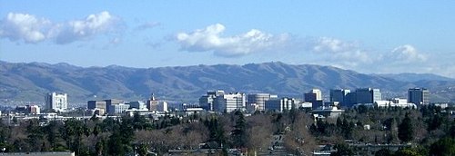
::太平洋构造板块正向北移动 相对北美板块而言The Pacific Coast represents a large population center a continent away from what we consider the North American core. Most of the region's population is urban, and Los Angeles and its metropolitan area is by far the largest area of settlement. Twelve percent of the US population lives in California, and the greater Los Angeles metropolitan area has more than 16 million people. Los Angeles is the second largest US city after New York.
::太平洋海岸是一个巨大的人口中心,是一个远离我们所认为的北美核心的大陆。 该地区大部分人口是城市人口,洛杉矶及其大都会地区是迄今为止最大的定居地区。 美国人口的12%生活在加利福尼亚,而大洛杉矶大都会地区人口超过1600万。 洛杉矶是仅次于纽约的第二大城市。Los Angeles is an automobile city. It developed into a major city in the mid-20th century at the time that automobile ownership had become common. People who lived in the area tended to move to suburbs that were connected to each other by an extensive highway system. Los Angeles is a highly decentralized city, unlike cities in other parts of North America that formed during other transportation regimes.
::洛杉矶是一个汽车城市。 在20世纪中叶汽车所有制变得司空见惯的时候,它发展成为一个大城市。 居住在这一地区的人往往搬到通过广泛的高速公路系统相互连接的郊区。 洛杉矶是一个高度分散的城市,不同于北美其他地区在其他交通制度下形成的城市。The Pacific Coast region is also famous for its agriculture. California’s lies between the Coast Ranges to the west and the Sierra Nevada to the east. It is one of the most productive agricultural areas in the world. The irrigated farmland in the valley produces all types of non-tropical crops and is the largest US producer of tomatoes, grapes, almonds, and many other foods. When other parts of the country are still frozen in the winter months, the fields of the Central Valley are already producing bountiful harvests. California is also famous for its wine production, especially in Napa Valley near San Francisco.
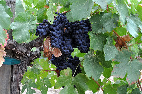
::太平洋沿岸地区也以农业闻名。 加利福尼亚位于西边的海岸地带和东边的内华达山脉之间。 它是世界上最有生产力的农业地区之一。 河谷的灌溉农田生产各种非热带作物,也是美国最大的番茄、葡萄、杏仁和许多其他食品生产国。 当美国其他地区在冬季仍被冻结时,中部谷地的田地已经生产丰盛的收获。 加利福尼亚也因其葡萄酒生产而闻名,特别是在旧金山附近的纳帕谷地。
Napa Valley is considered to be one of the premier wine regions in the world.
::纳帕谷被认为是世界上首要的葡萄酒区之一。
Besides agriculture, the economic base of the Pacific Coast is diverse and rich. If it were an independent country, California would be the world’s sixth-largest economy. Los Angeles is considered the capital of the US entertainment industry and other major industries including aerospace, manufacturing, and foreign trade. The port of Los Angeles is the busiest in North America, receiving shipments of goods from China and other Asian countries. Silicon Valley, near San Francisco, is a key area for high-tech research and Internet commerce. The Pacific Northwest is home to major corporations such as Boeing, Microsoft, Starbucks, Amazon.com, REI, T-Mobile, Costco, and Eddie Bauer. One of the wealthiest Americans, Bill Gates, lives near Seattle.
::除了农业之外,太平洋海岸的经济基础是多样化的和丰富的。 如果是一个独立国家,加利福尼亚将成为世界第六大经济体。 洛杉矶被认为是美国娱乐业和其他主要行业的首都,包括航空航天、制造业和外贸。 洛杉矶港是北美最繁忙的港口,接收来自中国和其他亚洲国家的货物。 旧金山附近的硅谷是高科技研究和互联网商务的关键领域。 太平洋西北地区是波音、微软、星巴克、亚马逊.com、REI、T-Mobile、Costco和Eddie Bauer等大公司的所在地。 最富有的美国人之一,比尔盖茨(Bill Gates)住在西雅图附近。
Silicon Valley is a region in the southern San Francisco Bay Area of Northern California.
::硅谷是北加利福尼亚州旧金山湾地区南部的一个地区。
Across the border to the north, is Canada’s third-largest metropolitan area with over two million residents. Vancouver is unlike any other city in North America. Nearly one-third of its residents are of Chinese origin, and more than half its population speak a language other than English at home. Vancouver began as a logging town but developed into its position as the Asian gateway to Canada because of its port, the busiest in Canada. Vancouver is a popular location for the film industry and is sometimes dubbed as “Hollywood North.” It is also growing in the biotechnology and software industries.
::温哥华是加拿大第三大大都市地区,居住人口超过200万。 温哥华与北美其他城市不同。 其近三分之一的居民来自中国,半数以上的居民在家中讲英语以外的语言。 温哥华最初是一个伐木镇,但由于港口是加拿大最繁忙的港口而发展成为通往加拿大的亚洲门户。 温哥华是电影业最受欢迎的场所,有时被称为“胡莱伍德北区 ” 。 在生物技术和软件行业中,温哥华也在增长。The North
::北 北The North is the least densely populated of any region in North America due to its brutally cold winters, short growing season, and poor soils. It includes the boreal forests of the upper Great Lakes region and the Canadian Shield and the territory to the north of the tree line that extends beyond the Arctic Circle. Physically, this region is immense, including the state of Alaska and most of Canada. The climate is similar to that of Russia with cold continental and arctic climates, arctic air masses swooping down from the north, and long winters. Most inhabitants of the northern portions of North America live in the forested areas rather than in the frozen Arctic.
::北方是北美任何地区人口密度最小的地区,原因是寒冷的冬季、生长季节短、土壤贫瘠,包括上大湖地区的北方森林和加拿大盾牌,以及北极圈以外树木线以北的领土。从身体上看,这个地区面积巨大,包括阿拉斯加州和加拿大大部分地区。气候类似于俄罗斯,其大陆和北极气候寒冷,北极空气从北方向下倾斜,冬季长。北美北部大部分居民居住在森林地区,而不是冰冻的北极地区。Two groups of people live in this region. First, there are the indigenous peoples who have lived in this region for thousands of years. They are small in number and traditionally make a living by hunting and fishing. More recently, the native populations such as the and the in Canada subsist by combining wage employment with their traditional means of living off the land. American Indians or Alaskan natives make up about 15 percent of Alaska’s population. In Canada’s Northwest Territories, First Nations people make up just over half of the population, but the total population is small. is the northernmost territory in Canada and has a population of approximately 35,000 of which 85 percent are Inuit.
::两组人居住在这个地区。第一,有土著人民在这个地区居住了几千年,他们人数很少,传统上靠打猎和捕鱼谋生。最近,加拿大的土著居民,例如加拿大的土著居民和加拿大的土著居民,通过将有薪就业与其传统的靠地谋生的手段结合起来来维生。美国印第安人或阿拉斯加土著人占阿拉斯加人口的15%左右。在加拿大西北地区,原住民占人口一半以上,但总人口却很小。 加拿大最北部的领土是加拿大,人口大约35 000人,其中85%是因努伊特人。
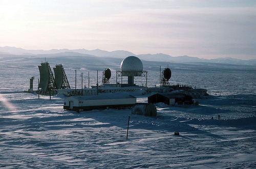
Distant Early Warning (DEW) line station formerly at Point Lay, Alaska.
::以往在阿拉斯加Point Lay的远距预警线站。
The other residents are more recent immigrants who are there to profit from the land’s natural resources. The economy is dominated by forestry, oil and natural gas extraction, and mining, which are in the primary economic sector. In the Canadian Shield, metallic ores such as copper, gold, nickel, silver, and uranium are found in the rocks. Moreover, diamond mines are in operation, as are mines producing rare earth elements used in computer screens, electric car batteries, and computer hard drives. These elements include metals such as cerium, terbium, dysprosium, and neodymium. Alaska is an oil-producing state, and the decision of whether to open additional areas of Alaska’s Arctic to oil drilling remains controversial and uncertain.
::其他居民都是新近移民,他们在那里从土地的自然资源中获利。 经济以林业、石油和天然气开采以及采矿为主,而采矿业则位于初级经济部门。 在加拿大盾牌公司,铜、金、镍、银和铀等金属矿石在岩石中被发现。 此外,钻石矿也在运行,在计算机屏幕、电动汽车电池和计算机硬盘中生产稀土元素的矿井也是如此。 这些元素包括、、和等金属。 阿拉斯加是一个石油生产国,而是否开放阿拉斯加北极更多地区进行石油钻探的决定仍然争议和不确定。
Key Takeaways
::密钥外出-
The economic core of North America has traditionally been in the US Northeast and its surrounding territory.
::北美的经济核心历来位于美国东北部及其周边地区。 -
As you move north from Boston into the rest of New England, the Canadian Maritimes, and Quebec, the economy is increasingly based on primary industries such as forestry and fishing.
::随着你从波士顿向北移动 到新英格兰的其他地方, 加拿大海洋和魁北克, 经济越来越 以初级工业为基础, 如林业和渔业。 -
Agriculture and mining have been in decline in the South, while tertiary and quaternary industries have attracted new migrants to the region’s urban and suburban areas.
::南方的农业和采矿业下降,而第三产业和四产业吸引了新的移民到该区域的城市和郊区。 -
The Midwest and the Great Plains make up North America’s breadbasket. The climate gets more arid as you move west, but through irrigation, agricultural productivity remains high.
::中西部和大平原构成了北美的面包篮。 随着你向西移动,气候越来越干旱,但通过灌溉,农业生产率仍然很高。 -
The Southwest is unique in its high proportion of Hispanic and Native American residents.
::西南地区独特的是,西南地区西班牙裔和美洲土著居民比例很高。 -
The Mountain West is growing rapidly, especially in its urban and suburban areas. This is putting stress on the physical environment (particularly its water resources) and made the region susceptible to the real estate collapse.
::西部山区正在迅速增长,特别是在城市和郊区,这给自然环境(特别是水资源)造成压力,使该区域易受房地产崩溃的影响。 -
The Pacific Coast region is prone to earthquakes and volcanic activity, yet it is home to the second-largest metropolitan area in the United States and is known for its rich, diverse economic base.
::太平洋沿岸地区容易发生地震和火山活动,但它是美国第二大都市地区的所在地,以其丰富多样的经济基础而闻名。 -
The far northern stretches of North America are sparsely populated, with an economy based on primary industries such as forestry and extraction. The North, both Canada and Alaska, is also known for its large native populations.
::北美最北端的人口稀少,其经济以林业和采掘等初级工业为基础,而加拿大和阿拉斯加的北方也以大量当地人口著称。
Vocabulary Terms
::词汇术语术语Chapter 3.3 Regions of the United States and Canada
::第3.3章 美国和加拿大地区a lluvial plain
::冲积平原An area of fertile soil left by river floods
::河流洪水留下的肥沃土壤面积Canadian Shield
::加拿大盾牌公司A northern part of the interior lowlands that is rocky, a flat region covering nearly two million square miles and encircling the Hudson Bay
::内地低低地北部岩石状地,一个覆盖近200万平方英里、环绕哈德逊湾的平坦地区Columbian Exchange
::哥伦比亚交易所The exchange of animals, plants, and diseases between America, Africa, and Europe following the voyage of Christopher Columbus . Trade from the Old World (Europe) to the New World (North and South America) and back
::克里斯托弗·哥伦布航行后美洲、非洲和欧洲之间动物、植物和疾病的交换。Continental Divide
::大陆分差T he line of the highest points in North America that marks the separation between rivers flowing eastward and westward
::北美最高点的界线,标志着向东和向西流动的河流的分界线e cumene
::普普尼A geographic region that is well suited for permanent settlement by people
::一个完全适合人民永久定居的地理区域First Nations
::第一民族第一民族A group of Canada's Native American people
::加拿大土著美洲人群体g laciation
::盐酸T he changing of landforms by slow-moving glaciers
::缓慢移动的冰川改变地貌Great Plains
::大平原A vast grassland of central North America that is largely treeless and as cends to 4,000 feet above sea level.
::北美中部一片广阔的草原 基本上没有树木 而且升至海拔4000英尺h ydroelectric Power
::水力发电Electricity that is generated from the power of moving water.
::电力来自移动水的动力。m etis
::A person of mixed French-Canadian and Native American ancestry
::混居法国-加拿大人和土著美洲人后裔m oraine
::闪光光A mass of dirt and rock that has been left by a glacier as it retreats
::冰川退缩时留下的 大量的土土和岩石p arliament
::议会议会 议会A representative lawmaking body whose members are e lected or appointed in which legislative and executive functions are combined
::具有代表性的立法机构,其成员经选举或任命产生或任命,立法和行政职能合并的立法机构和行政机构p ost industrial economy
::后工业化经济An economic phase in which manufacturing no longer plays a dominant role
::制造业不再发挥主导作用的经济阶段Rust Belt
::鲁斯特贝带Also known as the manufacturing belt , it is located in the northeastern parts of the United States and Midwest states that contain older industries and factories
::它位于美国东北部和中西部各州,内有老工业和工厂。St. Lawrence Seaway
::圣劳伦斯海路North America's most important deepwater ship route, connecting the Great Lakes to the Atlantic Ocean by way of the St. Lawrence River
::北美最重要的深水船航道,通过圣劳伦斯河连接大湖和大西洋Sun Belt
::太阳带A wide area of the United States that has a mild climate all year
::全年气候温和的美国大片地区Applying Knowledge
::应用知识Interactive Notebook Activities
::互动笔记活动-
Name the key characteristics of the regions of the United States and Canada.
::列出美国和加拿大地区的主要特点。 -
Describe the patterns of population growth or decline for the various regions.
::描述各区域的人口增长或下降模式。 -
List which regions have significant minority groups and why.
::列出哪些区域有大量少数群体及其原因。 -
Explain the relationship between the environmental and social costs to rapid growth in the West.
::解释环境和社会代价与西方快速增长之间的关系。 -
Summarize how physical geography has contributed to economic activities.
::概述地理地理对经济活动的贡献。
Discussion and Study Questions
::讨论和研究问题-
Where is the largest US megalopolis located? What region is it part of?
::美国最大的大都会在哪里?它属于哪个地区? -
What is the purpose of long lots? Where would they be most prominent?
::长途跋涉的目的是什么?它们在哪里最突出呢? -
What have been some of the traditional economic activities in the American South? How is this changing?
::美国南部的传统经济活动有哪些?这种变化如何? -
Why is there a difference between where spring wheat and winter wheat is grown?
::为什么春季小麦和冬季小麦的种植地有差别? -
Name the main ethnic groups that are prominent in the American Southwest.
::列出在美洲西南部最突出的主要族裔群体。 -
Why does the population continue to increase in the American West?
::为什么美国西部的人口继续增加? -
What makes the Pacific Coast region an unstable place for human development?
::是什么使太平洋沿岸地区成为人类发展不稳定的地方? -
Why does the Pacific Coast region have both high agricultural production and large high-tech urban cities?
::为什么太平洋沿岸地区既农业生产高,又拥有大型高技术城市? -
Why does the desert region of the American Southwest continue to attract a growing population?
::为什么美国西南部的沙漠地区继续吸引越来越多的人口? -
What have been the main economic activities in
The North
?
::北方的主要经济活动是什么?
Real-World Geography Exercise
::现实世界地理演习Using , find a large city located in one of the regions below. Calculate the distance and how long it would take to drive from your house to your chosen destination. Be prepared to share your answers.
::使用 ,请在下面的区域中找到一个大城市。计算从你家开到你所选择的目的地的距离和时间。准备分享你的答复。-
Northwestern Core
::西北核心 -
New England and the Canadian Maritimes
::新英格兰和加拿大海洋 -
French Canada
::法属加拿大 加拿大 -
The American South
::美国南部 -
The Midwest and Great Plains
::中西部和大平原 -
The American Southwest
::美国西南 -
The Mountain West
::山区西部 -
The Pacific Coast
::太平洋海岸 -
The North
::北 北
Mapping Exercise
::绘图绘制作业Mapping Our World ESRI-ARGIS Online Module 2 Lesson 2
::绘制我们世界的ESRI-ARGIS在线单元2: In this activity, students will investigate the Pacific Ocean’s Ring of Fire, with particular focus on earthquake and volcanic activity in East Asia, where millions of people live with the daily threat of significant seismic or volcanic events.
::学生们将调查太平洋的火环, 尤其关注东亚的地震和火山活动, 数百万人每天都生活在重大地震或火山事件的威胁之下。Videos for Geography Enrichment
::地理丰富视频Helpful Websites for the Study of Geography
::地理研究有用网站is an encyclopedia funded by the Canadian government covering all branches of knowledge. Their scholarly collection includes interactive materials.
::该百科全书由加拿大政府资助,涵盖所有知识分支,其学术收藏包括交互式材料。provides information on the people, history, government, economy, energy, geography, communications, transportation, military, and transnational issues for the world's entities.
::向世界各实体提供关于人民、历史、政府、经济、能源、地理、通信、运输、军事和跨国问题的资料。is a US government website where you can find federal legislation, past and present, as well as information about the US legal system.
::是一个美国政府的网站,您可以在此找到过去和现在的联邦立法以及关于美国法律制度的信息。is a government agency website that provides current news, resources, topics of interest, information about drugs, careers in the DEA, and a tip hotline.
::是一个政府机构网站,提供最新消息、资源、感兴趣的话题、毒品信息、在缉毒局的职业以及一条小费热线。is the largest library in the world and provides manuscripts, files, information, pictures, and videos.
::图书馆是世界上最大的图书馆,提供手稿、文件、信息、图片和录像。is a US government agency website that allows users to search for and retrieve satellite images of Earth.
::这是一个美国政府机构的网站,用户可以搜索和检索地球的卫星图像。is a US government website that provides historical documents, photos, records, publications, and educator resources.
::这是一个美国政府网站,提供历史文件、照片、记录、出版物和教育资源。is a US government agency website that provides weather-related information and ocean research.
::是一个提供气象信息和海洋研究的美国政府机构网站。is a website by the United States Geological Survey and other federal, state, and local agencies that deliver topographic information for the United States.
::这是美国地质调查局和其他联邦、州和地方机构为美国提供地形信息的网站。is a massive central data source and a handy way to graphically compare nations.
::是一个庞大的中央数据源,是用图形比较国家的一种方便方式。is a website that measures most locations in the world for air pollution in real time.
::是一个实时测量世界上大多数空气污染地点的网站。is a unique statistical database, which allows you to research and compare a multitude of different data on US states.
::这是一个独特的统计数据库, 使你能够研究和比较关于美国各州的多种不同数据。is an international organization founded in 1945 and made up of 193 member states. The UN maintains international peace and security, protects human rights, delivers humanitarian aid, promotes sustainable development, and upholds international law.
::联合国是一个国际组织,成立于1945年,由193个成员国组成。 联合国维护国际和平与安全,保护人权,提供人道主义援助,促进可持续发展,维护国际法。is a US government agency that provides a population clock, data, surveys, statistics, a library with information and infographics, news about the economy, and much more.
::这是一个美国政府机构,它提供人口钟、数据、调查、统计、一个拥有信息和信息资料的图书馆、关于经济的新闻,以及更多。is a US government agency website that provides scientific information about the natural hazards that threaten lives, the natural resources we rely on, the health of our ecosystems and environment, and the impacts of climate and land-use change.
::这是一个美国政府机构的网站,提供科学信息,说明威胁生命的自然危害、我们赖以生存的自然资源、生态系统和环境的健康以及气候和土地使用变化的影响。is a US government website that provides the latest presidential news, information about the budget, policy, defense, and many more topics.
::提供最新总统新闻、预算、政策、国防等资讯, 以及更多议题。is under the United Nations and provides leadership on matters critical to health, shapes the research agenda on health, and monitors the health situation and assessing health trends around the world. Their website provides information on the state of health around the world, outbreaks, current health news, and more.
::网站提供世界各地卫生状况、疫情爆发、最新卫生新闻等信息。is an intergovernmental organization that regulates international trade. The website provides information on the history of the multilateral trading system, featured videos, news and events, trade topics, and more.
::该网站提供关于多边贸易体系历史的信息、视频、新闻和事件、贸易专题等等。 -
Name the key characteristics of the regions of the United States and Canada.