4.5 南美洲:自然地理(1天)
章节大纲
-
Chapter Challenges
::章次 挑战-
Summarize briefly the main physical features and characteristics of South America.
::简要概述南美洲的主要物理特征和特征。 -
Explain how European colonialism dominated the realm and divided up the continent.
::解释欧洲殖民主义如何主导整个大陆, -
Describe the ethnic, economic, and political patterns in the Guianas.
::说明圭亚那的种族、经济和政治格局。 -
List the main cultural realms of South America.
::列出南美洲的主要文化领域。 -
Describe each realm’s main ethnic majority.
::说明每个地区的主要族裔多数。 -
Explain how colonialism impacted each region.
::说明殖民主义如何影响每个区域。 -
Summarize briefly how the South American countries are attempting to integrate their economies.
::简要总结一下南美洲国家如何试图实现经济一体化。
Student Learning Objectives
::学生学习目标TEKS Regional Unit 04: Chapter 4.5 South America: Physical Geography
::TEKS 区域股04:第4.5章南美洲:自然地理WG.1B Trace the spatial diffusion of phenomena such as the Columbian Exchange or the diffusion of American popular culture and describe the effects on regions of contact
::WG.1B 追踪哥伦比亚交流会等现象的空间扩散或美国流行文化的传播,并描述对接触区域的影响WG.2A Describe the human and physical characteristics of the same regions at different periods of time to evaluate relationships between past events and current conditions.
::WG.2A 描述不同时期同一区域的人的和自然的特征,以评估过去事件与当前状况之间的关系。WG.4A Explain how elevation, latitude, wind systems, ocean currents, position on a continent, and mountain barriers influence temperature, precipitation, and distribution of climate regions.
::WG.4A 解释高海拔、纬度、风力系统、洋流、大陆位置、山地屏障如何影响气候区域的温度、降水量和分布。WG.4C Explain the influence of climate on the distribution of biomes in different regions.
::WG.4C 解释气候对不同区域生物群落分布的影响。WG.5A Analyze how the character of a place is related to its political, economic, social, and cultural elements.
::WG.5A 分析一个地方的特性如何与其政治、经济、社会和文化因素相关。WG.7D Examine benefits and challenges of globalization, including connectivity, standard of living, pandemics, and loss of local culture.
::7D工作组审查全球化的好处和挑战,包括连通性、生活水平、流行病和当地文化的丧失。WG.9A Identify physical and/or human factors such as climate, vegetation, language, trade networks, political units, river systems, and religion that constitute a region.
::WG.9A 查明构成区域的自然和/或人类因素,如气候、植被、语言、贸易网络、政治单位、河流系统和宗教。WG.9B Describe different types of regions, including formal, functional, and perceptual regions.
::WG.9B 描述不同类型的区域,包括正式区域、功能区域和概念区域。WG.14C Analyze current events to infer the physical and human processes that lead to the formation of boundaries and other political divisions.
::WG.14C 分析当前事件,以推断导致形成边界和其他政治分裂的物质和人类过程。WG.12A Analyze how the creation, distribution, and management of key natural resources affects the location and patterns of movement of products, money, and people.
::WG.12A 分析关键自然资源的创造、分配和管理如何影响产品、货币和人员流动的地点和模式。WG.17C Compare economic, political, or social opportunities in different cultures for women, ethnic and religious minorities, and other underrepresented populations.
::WG.17C 比较妇女、族裔和宗教少数群体以及其他代表人数不足的人口在不同文化中的经济、政治或社会机会。WG.18A Analyze cultural changes in specific regions caused by migration, war, trade, innovations, and diffusion.
::WG.18A 分析移徙、战争、贸易、创新和传播在特定区域造成的文化变化。WG.18C Identify examples of cultures that maintain traditional ways, including traditional economies.
::WG.18C 查明保持传统方式的文化实例,包括传统经济。WG.19A Evaluate the significance of major technological innovations in the areas of transportation and energy that have been used to modify the physical environment.
::WG.19A 评价用于改变自然环境的运输和能源领域重大技术革新的重要性。WG.21C Create and interpret different types of maps to answer geographic questions, infer relationships, and analyze change.
::WG.21C 创建和解释不同类型的地图,以回答地理问题、推断关系和分析变化。WG.23B Use case studies and GIS to identify contemporary challenges and to answer real-world questions.
::WG.23B 利用个案研究和地理信息系统查明当代的挑战并回答现实世界的问题。WG,22A Design and draw appropriate graphics such as maps, diagrams, tables, and graphs to communicate geographic features, distributions, and relationships.
::设计和绘制适当的图形,如地图、图表、表格和图表,以交流地理特征、分布和关系。WG.22C Use geographic terminology correctly.
::WG.22C 正确使用地理术语。WG.22D Use standard grammar, spelling, sentence structure, and punctuation.
::WG.22D 使用标准语法、拼写、句子结构和标点。South America: Physical Geography
::南美洲:自然地理地理
The main two physical features of South America are the Andes Mountains and the Amazon River.
::南美洲的两个主要物理特征是安第斯山脉和亚马逊河。Physical Characteristics
::物理特征The continent of South America has a wide diversity of physical landscapes, from the high Andes Mountains to the tropical forests of the Amazon Basin. This assortment of physical features offers many resource bases. These resource bases allow people to engage in economic activity, gain wealth, and provide for their needs. The mountain range of the Andes holds mineral riches that have been being extracted since ancient times.
::南美洲大陆从安第斯山脉高地到亚马逊盆地热带森林的自然景观多种多样,各种自然特征的分布提供了许多资源基础,这些资源基础使人们能够从事经济活动、获得财富和满足他们的需要。安第斯山脉拥有自古以来开采的矿物财富。Fossil fuels have been found in abundance in the far northern regions of Venezuela and Colombia. The Amazon Basin has been a source of hardwood lumber and, more recently, extensive mineral wealth. Some of the largest iron-ore mines in the world are located here. The massive plains of Brazil and the rich soils of the Pampas allow for agricultural operations that provide food products for the continent and for the world.
::远在委内瑞拉和哥伦比亚北部的地区发现矿物燃料丰富,亚马逊流域是硬木木材的来源,最近也是大量矿产财富的来源,世界上最大的铁矿石矿区中有一些位于这里,巴西的广大平原和潘帕斯的肥沃土壤使农业活动得以进行,为非洲大陆和世界提供粮食产品。Even the inhospitable Atacama region in northern Chile holds some of the world’s largest copper reserves. The wide variety of climate zones allows a diverse range of species to develop. The extremes in physical geography in South America have created both barriers and opportunities to those who live there.
::即使是智利北部不友好的阿塔卡马地区也拥有世界上最大的铜储量。 气候区多种多样,使得多种物种得以发展。 南美地理上的极端状况给生活在那里的人们造成了障碍和机会。Before the era of European colonialism, many local groups organized themselves into states or empires. The Inca Empire was the largest in existence at the time the Europeans arrived. The early empires developed massive structures that required huge cut stones weighing many tons to be moved into place without the benefit of modern tools or technology. European colonialism altered the continent in several ways. The Europeans defeated and conquered Amerindian groups such as the Inca.
::在欧洲殖民主义时代之前,许多地方团体组织起来组成了国家或帝国。 印加帝国是欧洲人到达时最大的帝国。 早期的帝国发展了庞大的结构,需要巨大的切割石块才能在不受益于现代工具或技术的情况下将许多吨重的石头移到原地。 欧洲殖民主义以多种方式改变了非洲大陆。 欧洲人击败并征服了印加等美洲印第安人群体。Cultural exchanges also took place that altered the way of life for countless South Americans. Colonialism created many of the current country borders and influenced trade relationships with the newly created colonies. The plantation system and the introduction of slaves from Africa drastically changed the ethnic makeup of the people living along the eastern coast. After slavery was abolished, indentured servitude brought workers from Asia to support the labor base.
::此外,还进行了文化交流,改变了无数南美人的生活方式。 殖民主义创造了许多目前的国界,影响了与新建立的殖民地的贸易关系。 种植园制度和非洲奴隶的引入极大地改变了生活在东海岸的人民的民族构成。 奴隶制被废除后,契约奴役使亚洲工人支持劳动力基础。Indentured servants were usually poor individuals who agreed to work for an agreed upon period of time, usually less than seven years, in return for the necessities of life such as lodging, food, and transportation or clothing. These individuals did not usually receive a salary but may have received a lump sum payment upon completion of the agreed upon service. Under favorable conditions indentured servants were treated like relatives and gained important experience and job skills to provide for their future. On the other hand, many died of disease and harsh conditions.
::契约仆人通常是穷人,他们同意在商定的期限内工作,通常不到7年,以换取生活必需品,如住宿、食物、交通或衣物,这些人通常得不到工资,但在完成商定服务后可能领取一笔一次性付款,在有利的条件下,契约仆人被当作亲戚对待,并获得重要的经验和工作技能,以维持他们的未来;另一方面,许多人死于疾病和恶劣的条件。The physical environment and the influence of colonialism were both responsible for the cultural attributes of the regions of South America. The continent can be divided into regions by ethnic majorities influenced by early colonial development. The mixing of ethnic groups from Europe, Africa, and Asia with each other or with the indigenous population has created a diverse cultural mosaic.
::自然环境和殖民主义的影响对南美洲地区的文化特性都负有责任,非洲大陆可以按受早期殖民发展影响的族裔多数划分为几个区域,欧洲、非洲和亚洲的族裔群体彼此之间或与土著人口混杂在一起,形成了多样化的文化模式。For example, most people in Guyana and Suriname are from Asia, most people in Argentina and Uruguay are from Europe, most people in Peru and Bolivia are Amerindian, and most people in many areas along the eastern coast of Brazil are of African descent. A large percentage of the population of South America is of a mixed ethnic background. Understanding the cultural geography of South American supports understanding of the realm’s human development patterns.
::例如,圭亚那和苏里南的大多数人来自亚洲,阿根廷和乌拉圭的大多数人来自欧洲,秘鲁和玻利维亚的大多数人是美洲印第安人,巴西东海岸许多地区的大多数人是非洲后裔,南美洲人口中有很大比例的人口具有混杂的种族背景。 了解南美洲的文化地理背景有助于理解这个地区的人类发展模式。South America’s modern economic development has helped integrate it with the global economy. The levels of economic development vary widely within the realm. There are clear indications of core-peripheral spatial patterns within various regions of the continent, and rural-to-urban shift has been strong in many areas. The rural regions in the Andes or the interior suffer from a lack of economic support needed to modernize their infrastructure.
::南美的现代经济发展帮助它融入了全球经济。 该地区经济发展水平差异很大。 非洲大陆不同地区的核心周边空间模式有明显迹象,许多地区农村向城市的转变十分强劲。 安第斯或内地的农村地区缺乏现代化基础设施所需的经济支持。At the same time, metropolitan areas are expanding rapidly and are integrated with global markets and the latest technologies. Most of the large cities are located along the coastal regions. This pattern of urbanization is mainly a result of colonial activity and influence. The countries of South America are working among themselves to network trade and commerce activities. Trade agreements and economic unions have become standard methods of securing business partnerships to enhance the realm’s economic opportunities.
::与此同时,大都市地区正在迅速扩大,并与全球市场和最新技术相结合,大多数大城市都位于沿海地区,这种城市化模式主要是殖民活动和影响造成的,南美洲各国正在彼此合作,建立贸易和商业活动网络,贸易协定和经济联盟已成为确保商业伙伴关系以加强该地区经济机会的标准方法。Physical Geography
::物理地理The far-reaching and the massive system dominate South America’s physical geography. The 5,000-mile-long Andes Mountain chain extends along the entire western region of the continent from Venezuela to southern Chile. The Andes are the longest mountain chain on Earth and the highest in the Americas. The Andes Mountain range has more than 30 peaks that reach at least 20,000 feet in elevation, many of which are active volcanoes.
::影响深远和规模庞大的体系主宰着南美洲的地理地理。 安第斯山脉链条5 000英里长,从委内瑞拉延伸到智利南部,横跨整个大陆的西部地区。 安第斯山脉是地球上最长的山脉链,也是美洲最高的。 安第斯山脉山脉有30多个峰值,至少达到20,000英尺高,其中许多是活火山。The Andes has provided isolation to the , mineral wealth to those with the means for extraction, and a barrier to travelers crossing the continent. The Andes’ minerals include gold, silver, tin, and other precious metals. Mining became a major industry in the colonial era and continues to the present.
::安第斯山脉孤立了安第斯山脉、矿产财富与拥有开采手段的人,以及穿越大陆的旅行者。 安第斯山脉的矿产包括金、银、锡和其他贵金属。 采矿成为殖民时代的主要产业,并一直延续至今。At the core of the continent is the mighty Amazon River, which is more than 2,000 miles long and has an enormous drainage basin in the largest tropical rain forest in the world. The Amazon’s many tributaries are larger than many other world rivers. Flowing parallel to the equator, the Amazon rivals the Nile as the longest river in the world. The Amazon River has the greatest discharge of any river in the world. It carries about one-fifth of all river water in the world.
::非洲大陆的核心是强大的亚马逊河,它长2 000多英里,在世界上最大的热带雨林中拥有巨大的排水盆地。 亚马逊河的许多支流比世界其他河流要大。 亚马逊河与赤道平行,亚马逊河与尼罗河比作世界上最长的河流。 亚马逊河是世界上任何河流排放最多的地方。 亚马逊河约占世界河流总量的五分之一。The Amazon and its many tributaries drain the entire interior region of the continent, covering 40 percent of South America. During the rainy season, it can be more than 100 miles wide. No bridges span the Amazon River. Its source is a glacial stream located high in the Peruvian Andes, about 150 miles from the Pacific Ocean.
::亚马逊河及其许多支流吞噬了整个大陆的内地,占南美洲的40%。在雨季,其宽度可能超过100英里,亚马逊河上没有桥梁,其源头是位于秘鲁安第斯山脉高地的冰川流,距离太平洋约150英里。The Amazon’s extended tributaries—such as the Rio Negro, the Madeira, and the Xingu—move massive amounts of water through the Amazon Basin and are major rivers in their own right. The Amazon has more than 1,100 tributaries; a dozen are more than 1,000 miles long. Hydroelectric dams are located on the tributaries to produce electricity for the region’s fast-growing development.
::亚马孙的延伸支流 — — 如里约内格罗、马德拉和辛古 — — 将大量水流通过亚马逊流域,并成为它们本身的主要河流。 亚马逊有1,100多个支流,十几个长1 000多英里。 水力发电大坝位于支流上,为该地区的快速发展提供电力。South America has additional large rivers that drain the continent, including the Orinoco, which flows through Venezuela; the Sao Francisco, which flows through southeast Brazil; and the Paraguay and the Paraná Rivers, which flow south from Brazil into the Rio de la Plata between Argentina and Uruguay.
::南美洲还有其他大河流,使非洲大陆排水,包括经由委内瑞拉流经奥里诺科的奥里诺科河;穿越巴西东南部流经圣弗朗西斯科河;以及从巴西向南流入阿根廷和乌拉圭之间拉普拉塔河的巴拉圭河和巴拉那河。The Altiplano Region is a wide basin between two main Andean mountain ranges. The word altiplano means “valley” in Spanish. There are a substantial number of altiplanos in South America. They provide for agricultural production and human habitation. The Altiplano Region has been home to ancient civilizations that date back to early human settlements.
::Altiplano区域是安第斯两大山脉之间的一个宽阔盆地,在西班牙文中,“Altiplano”一词的意思是“valley”,在南美洲有大量的altiplanos,用于农业生产和人类居住,阿尔蒂plano区域是古代文明的家园,这些古代文明可追溯到早期的人类住区。Lake Titicaca rests in the middle of the Altiplano Region of the Central Andes on the border between and . Lake Titicaca is a large freshwater lake about 120 miles long and 50 miles wide. The surface is at an elevation of about 12,000 feet above sea level. The lake is more than 900 feet deep in some areas. Usually at such high elevations, the temperature would dip below freezing and restrict agriculture. However, the large lake acts as a solar energy collector by absorbing energy from the sun during the day and giving off that energy in the form of heat during the night. The energy redistribution allows for a moderate temperature around the lake that is beneficial to growing food crops.
::喀喀同盟湖位于安第斯中部阿尔蒂普拉诺地区中部,位于安第斯中部的边界,北喀同盟湖是一个大淡水湖,长约120英里,宽约50英里,海平面高约12 000英尺,有些地区湖深超过900英尺,通常温度会降到冰冻之下,限制农业;但大湖作为太阳能收集器,白天吸收太阳的能量,夜间以热量的形式提供这种能量;能源重新分配使湖周围温和,有利于种植粮食作物。With abundant fresh water and the ability to grow food and catch fish, the Altiplano Region has supported human habitation for thousands of years. On the Bolivian side of the lake is the ancient stone site of Tiahuanaco, which has had some artifacts dated to 1500 B.C.E. or earlier. People continue to live around and on Lake Titicaca and maintain a subsistence lifestyle.
::Altiplano地区拥有丰富的淡水以及种植食物和渔获鱼的能力,数千年来一直支持人类居住,在玻利维亚湖的玻利维亚一侧是蒂亚胡纳科的古老石块遗址,那里的一些文物可追溯到公元前1500年或更早,人们继续在喀喀湖周围和湖上生活,并维持生计。
Lake Titicaca is the highest-elevation navigable lake in the world.
::喀喀湖是世界上最高海拔的可航行湖。
Across the Andes Mountains from the Altiplano Region is the Atacama Desert. The Atacama is one of the driest places on Earth. In some parts, no rain has fallen in recorded history. Under normal circumstances, the Atacama would be a desolate region without human activity, but that is not the case. Some of the world’s largest copper reserves are found here. Nitrates, which are used in fertilizers, are also found in large quantities. Mining the Atacama has brought enormous wealth to many people.
::位于阿尔提平原地区的安第斯山脉横穿大西洋沙漠。 阿塔卡马是地球上最干燥的地方之一。 在有些地方,没有降雨记录下来。 在正常情况下,阿塔卡马将是一个没有人类活动的荒凉地区,但情况并非如此。 世界上最大的铜储量有一些在这里。 用于肥料的硝酸盐也大量存在。 阿塔卡马采矿给许多人带来了巨大的财富。The rain shadow effect is responsible for the extraordinary dryness of the Atacama. The Andes are quite high at this latitude, and the winds blow in rain clouds from the east. When the clouds reach the mountains, they ascend in elevation, releasing their precipitation without ever reaching the western side of the Andes.
::雨影效应是阿塔卡马河异常干燥的原因。 安第斯山脉在这个纬度上相当高,东边的雨云中吹着风。 当云到达山顶时,它们升起高空,降下雨水时从未到达安第斯山脉的西面。South America has large agricultural plateaus east of the Andes, such as the Mato Grosso Plateau. It includes a portion of the great Cerrado agricultural region of central Brazil. The Cerrado is a vast plain that has been developed for agriculture and produces enormous harvests of soybeans and grain crops. Bordering the Cerrado to the southeast are the Brazilian Highlands, an extensive coffee-growing region. The Pampas in eastern Argentina, Uruguay, and southernmost Brazil is another excellent agricultural region with good soils and adequate rainfall. Farming, cattle ranching, and even vineyards can be found here, making the Pampas the breadbasket of the Southern Cone.
::南美洲在安第斯山脉以东有大片农业高原,如马托格罗索高原,包括巴西中部大塞拉多农业区的一部分,塞拉多是一块广阔的平原,为农业开发,生产大量大豆和谷物作物,巴西高原与东南部相邻的塞拉多是巴西高原,咖啡种植面积很大,阿根廷东部、乌拉圭和巴西最南端的潘帕斯是另一个土壤肥沃、降雨量充足的农业地区。 这里可以找到农业、牛牧业、甚至葡萄园,使潘帕斯成为南锥体的粮盆。To the south of the Pampas is the lengthy expanse of Patagonia, which covers the southern portion of Argentina east of the Andes. Patagonia is a prairie grassland region that does not receive much rainfall because of the rain shadow effect of the Andes to the west. The main activities in Patagonia are the raising of cattle and other livestock. The region is starting to attract attention to the extraction of natural resources such as oil, natural gas, and valuable minerals.
::帕帕帕斯以南是长长的帕塔哥尼亚大片,覆盖阿根廷安第斯山脉以东的南部,巴塔哥尼亚是一个草原地区,由于西部安第斯山脉的雨影效应,降雨量不大,巴塔戈尼亚的主要活动是饲养牲畜和其他牲畜,该地区开始吸引人们注意开采石油、天然气和贵重矿物等自然资源。To the northern part of the continent in Venezuela and Colombia, sandwiched between the Andes Mountains and the Guiana Highlands , is a grassland region with scrub forests called the Llanos. The human population is small because of the remoteness of the region along the Orinoco River basin. The Guiana Highlands of southeast Venezuela and the Guianas are an isolated set of mountainous plateaus mixed with rugged landscapes and tropical climates. Angel Falls, the highest waterfall in the world, with a free fall of more than 2,647 feet and a total drop of about 3,212 feet (more than half a mile), is located here. To the northwest of the Llanos and the Guiana Highlands in Venezuela is Lake Maracaibo, a large inland lake open to the Caribbean Sea. A coastal lake, Maracaibo rests atop vast oil reserves that provide economic wealth for Venezuela.
::委内瑞拉和哥伦比亚大陆北部,位于安第斯山脉和圭亚那高原之间,是一片草原地区,林林称为Llanos,由于奥里诺科河流域偏远,人口很少,委内瑞拉东南部和圭亚那的圭亚那高地是一块孤立的山区高原,布满崎岖的地貌和热带气候。天使瀑布是世界上最高的瀑布,自由降水超过2 647英尺,总降水约3 212英尺(超过半英里)。在委内瑞拉拉诺斯和圭亚那高地的西北部,是马拉开波湖,这是向加勒比海开放的大内陆湖。沿海湖泊Maracaibo位于为委内瑞拉提供经济财富的广阔石油储量之上。European Colonialism
::欧洲殖民主义 欧洲殖民主义South America’s colonial legacy shaped its early cultural landscape. The indigenous people, with their empires and local groups, were no match for the European colonizers. South America was colonized exclusively by two main Iberian powers: Spain colonized the western part of South America, and Portugal colonized the east coast of what is present-day Brazil. The only region that was not colonized by those two powers was the small region of the Guianas, which was colonized by Great Britain, the Netherlands, and France.
::南美洲的殖民遗产塑造了它早期的文化景观。 土著人民及其帝国和地方团体与欧洲殖民者不相配。 南美洲完全被两大伊比利亚大国殖民:西班牙殖民了南美洲西部,葡萄牙殖民了当今巴西的东海岸。 唯一没有被这两个大国殖民的地区是被英国、荷兰和法国殖民的圭亚那小地区。
Colonial Activity in South America
::南美洲的殖民活动
Everything changed with the invasion of the Iberian colonizers. The culture, religion, and economics of the local indigenous people were disrupted and forced to change. The Spanish and Portuguese languages, as well as the Roman Catholic religion, superseded the languages and religions that had previously existed.
::随着伊比利亚殖民者的入侵,一切都发生了变化,当地土著人民的文化、宗教和经济受到干扰,被迫改变,西班牙语和葡萄牙语以及罗马天主教取代了以前存在的语言和宗教。Colonialism also was responsible for transporting food crops such as the potato, which originated in the Peruvian Andes, to the Europeans. Today, coffee is a main export of Colombia, Brazil and other countries in the tropics. Coffee was not native to South America but originated in Ethiopia and was transferred by colonial activity. The same is true of sugarcane, bananas, and citrus fruits. Oranges were not native to South America, but today Brazil is the number one exporter of orange juice. Colonialism was driven by the desire for profit from the quick sale of products such as gold or silver. There was a ready market for goods not found in Europe, such as tobacco, corn, exotic animals, and tropical woods.
::殖民主义还负责向欧洲运送土豆等粮食作物,这些作物原产于秘鲁安第斯山脉;今天,咖啡是哥伦比亚、巴西和热带其他国家的主要出口产品;咖啡原产于南美洲,但原产于埃塞俄比亚,由殖民活动转移;甘蔗、香蕉和柑橘水果也是如此;橙子原产于南美洲,但今天巴西是橙汁的头号出口国;殖民主义的驱动力是希望迅速销售黄金或银类产品获得利润;欧洲没有的商品,如烟草、玉米、外来动物和热带森林,现成的市场。Plantation agriculture introduced by the Europeans led to a high demand for manual laborers. When the local populations could not meet the labor demand, millions of Africans were brought through the slave trade. These African slaves introduced their own unique customs and traditions, altering the culture and demographics of the Western Hemisphere. The current indigenous Amerindian population, a fraction of what it was before the Europeans arrived, makes up only a small percentage of South America’s total population. Europeans took the best land and controlled the economic trade of the region. The acculturation in South America is directly related to the European colonial experience.
::欧洲人引进的种植园农业导致了对体力劳动者的高需求。 当当地人口无法满足劳动力需求时,数百万非洲人通过奴隶贸易而成为奴隶。 这些非洲奴隶引入了他们自己的独特的习俗和传统,改变了西半球的文化和人口统计。 目前的土著美洲印第安人人口只占欧洲人到达之前的一小部分,只占南美洲总人口的一小部分。 欧洲人占据了最好的土地,控制了该地区的经济贸易。 南美的种植与欧洲殖民经验直接相关。The Inca Empire and Francisco Pizarro
::印加帝国和弗朗西斯科·皮萨罗Not long after conquered the of Mexico in 1521, a young Spanish conquistador named , stationed in what is now Panama, heard rumors of silver and gold found among the South American people. He led several sailing excursions along the west coast of South America. In 1531 C.E., he founded the port city of Lima, Peru.
::在1521年征服了墨西哥不久之后,一位名叫西班牙的年轻征服者(现驻巴拿马)在巴拿马,听说南美洲人中发现了银金的谣言。 他率领南美西海岸的几次航海旅行。 1531年,他成立了秘鲁利马港市。Since 1200 C.E., the Inca had ruled a large empire extending out from central Peru, which included the high-elevation Altiplano Region around Lake Titicaca. dominated an area from Ecuador to Northern Chile. The Inca were not the most populous people but were a ruling class who controlled other subjugated groups.
::自公元1200年以来,印加人统治了一个从秘鲁中部延伸而来的大帝国,其中包括在提喀卡湖周围高海拔高原地区。 从厄瓜多尔到智利北部,印加人控制着一个地区。 印加人不是人口最多的人,而是统治阶级,控制着其他下层群体。Pizarro, with fewer than 200 men and 24 horses, met up with the Inca armies and managed to defeat them in a series of military maneuvers. The Inca leader was captured by the Spanish in 1533. Two years later, in 1535, the Inca Empire collapsed.
::Pizarro拥有不到200人和24匹马,与印加军队会面,并在一系列军事演习中击败了他们。 印加领导人于1533年被西班牙人俘虏。 两年后,1535年,印加帝国垮台。The Inca Empire was important to European conquerors because of the high volume of gold and silver found in the Andes. The story is told that Pizarro placed the captured Inca leader in a small room and told him that if the room was filled with gold to the top of the Inca leader’s head, Pizarro would let the Inca leader go free. Gold was summoned from the people and the countryside, and the room was filled.
::印加帝国对欧洲征服者很重要,因为在安第斯山脉中发现了大量的金银。 传闻说,皮萨罗将被捕的印加领导人安置在一间小房间里,并告诉他,如果该房间在印加领导人的头顶上装满金子,皮萨罗就会让印加领导人自由。 黄金被从人民和农村传来,房间被填满。The conquistadors forced the Inca leader to convert to Catholicism and then killed him. The gold was melted down and transported back to Spain. The mineral wealth of the Andes made the conquistadors rich. Lima was once one of the wealthiest cities in the world. Europeans continued to dominate and exploit the mining of minerals in Peru and Bolivia throughout the colonial era. European elites and the Mestizo ruling class have subjugated the Amerindian groups in the Andes since colonial times.
::征服者迫使印加领导人改信天主教,然后杀了他。黄金被熔化并运回西班牙。安第斯山脉的矿产财富使征服者富足。利马曾经是世界上最富有的城市之一。在整个殖民时代,欧洲人继续统治和开采秘鲁和玻利维亚的矿产开采。欧洲精英和梅斯蒂索统治阶级自殖民时代以来征服了安第斯山脉的美洲印第安人群体。
The original church was constructed in 1571 on the site of the ancient Incan palace. The earthquake of 1650 caused severe damage to the building, so it had to be reconstructed in about 1688. Many Catholic cathedrals in Latin America were built with stones from ancient sites. This cathedral is claimed to be the Western Hemisphere’s most ideal example of colonial baroque architecture.
::原教堂建于1571年,建于古老的印加宫殿所在地。 1650年的地震对这座建筑造成了严重破坏,因此不得不在1688年左右重建。 拉丁美洲的许多天主教教堂都是用古老遗址的石块建造的。 这座教堂据称是西半球殖民巴洛克建筑中最理想的例子。
Many Amerindian groups inhabited this region before the Inca Empire, such as the people who built and lived in the ancient city of Tiahuanaco. In fact, humans have lived in South America for thousands of years. There is speculation that travel between South America and the Mediterranean region occurred earlier than current historical records indicate. Many of the ruins in the western region of South America have not been thoroughly excavated and examined by archaeologists. The size and scope of many of the stone structures show the advancements in engineering and technology employed in an era that, according to historical records, had only primitive tools.
::许多美洲印第安人群体在印加帝国之前就居住在这一地区,如在古代城市蒂亚胡纳科建造和居住的人,事实上,人类在南美洲居住了几千年,人们猜测南美洲和地中海区域之间的旅行比目前历史记录显示的要早,南美洲西部地区的许多废墟没有经过考古学家的彻底挖掘和检查,许多石块结构的规模和范围表明在根据历史记录只有原始工具的时代,工程和技术的发展。The Spanish Division of the Continent
::非洲大陆西班牙分部The Spanish conquistadors were not the only European invaders to colonize South America. Colonial influence—which forced a change in languages, religion, and economics—also came from the small European kingdom of . Portuguese ships sailed along the eastern coast of South America and laid claim to the region for the king. The Portuguese did not find large gold or silver reserves, but they coveted the land for the expansion of their empire.
::西班牙征服者不是殖民南美洲的唯一欧洲侵略者。 殖民影响 — — 迫使语言、宗教和经济学发生变化 — — 也来自欧洲小王国。 葡萄牙船只沿南美洲东海岸航行,为国王对该地区拥有主权。 葡萄牙人没有找到庞大的黄金或银矿,但他们为扩张帝国而寻找土地。Soon the Spanish and the Portuguese were fighting over the same parts of South America. In 1494, the issue was brought before the Roman Catholic Church. The Tordesillas Line was drawn on a map to divide South America into the Spanish west and the Portuguese east. The region that is now became the largest Portuguese colonial possession in South America, a center for plantation agriculture similar to that in the Caribbean. For this reason, a large African population lives in Brazil, and most of the people in Brazil speak Portuguese and are Roman Catholics.
::不久,西班牙人和葡萄牙人就在南美洲的同一地区交战。 1494年,这个问题被提交罗马天主教会讨论。 托德西拉斯线被绘制在一张地图上,将南美洲划分为西西班牙人和东葡萄牙人。 该地区现在成为南美最大的葡萄牙殖民领地,一个类似于加勒比的种植园农业中心。 因此,大量非洲人口居住在巴西,巴西的大多数人讲葡萄牙语,是罗马天主教徒。Independence did not come for the Spanish colonies until 1816 and 1818 when and broke away in an independence movement in the south. Simón Bolívar led liberation movements in the north. By 1824, the Spanish were defeated in South America. Brazil did not gain independence from Portugal until 1822, when the prince of Portugal declared an independent Brazil and made himself Brazil’s first emperor. It was not until 1889 that a true republic was declared and the empire was abolished.
::西班牙殖民地直到1816年和1818年才获得独立,直到1816年和1818年,在南部的独立运动中,西蒙·玻利瓦尔领导了北部的解放运动。 到1824年,西班牙在南美洲被击败。 巴西直到1822年才从葡萄牙获得独立,当时葡萄牙王子宣布独立为巴西并成为巴西首任皇帝。 直到1889年,才宣布一个真正的共和国并废除帝国。Colonialism and the Guianas
::殖民主义和圭亚那The Guianas in the northeast were the only European colonies in South America that were not under Spanish or Portuguese control. The British, Dutch, and French all held claims to different parts of the Guianas. French Guiana remains a colony of France to this day. The transition from colony to an independent state has required persistence, time, and patience. and received their independence in the late 20th century.
::东北部的圭亚那是南美洲唯一不由西班牙或葡萄牙控制的欧洲殖民地。 英国、荷兰和法国都拥有对圭亚那不同地区的主张。 法属圭亚那至今仍是法国的殖民地。 从殖民地向独立国家的过渡需要持续、时间和耐心。 20世纪末,他们获得了独立。
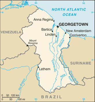
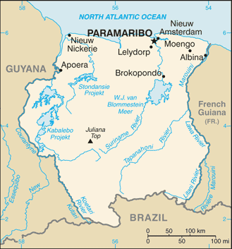
The Guianas of South America.
::南美洲的圭亚那。
The coastal location of the Guianas provided European colonialists with an excellent site for plantation agriculture. Coastal cities had easy access to the Atlantic trade system. The active slave trade in the Atlantic brought African slaves to the Guianas to work the plantations. When slavery was abolished, indentured servants were brought in from other parts of the world that were colonized by the same European powers. Colonialism and plantation agriculture changed the cultural dynamics of the Guianas. Port cities along the coast are the dominant urban centers. The Guianas follow a pattern similar to that of the rimland of the Caribbean and are included with the Caribbean in many studies. At the present time, bauxite mining and oil deposits along the coast provide an income, and many people make their living in subsistence agriculture.
::圭亚那的沿海位置为欧洲殖民主义者提供了优良的种植农地;沿海城市容易进入大西洋贸易体系;大西洋的活跃奴隶贸易使非洲奴隶来到圭亚那种植场;废除奴隶制后,来自世界其他地方的契约佣人从欧洲其他列强殖民的其他地方被带进来;殖民主义和种植园农业改变了圭亚那的文化动态;沿海港口城市是主要的城市中心;圭亚那与加勒比滨海地区类似,许多研究都包括了加勒比。目前,沿海的铝土开采和石油矿藏提供了收入,许多人靠自给农业维生。Guyana
::圭亚那
Map of Guyana
::圭亚那地图
and its neighbors have a tropical type A climate. The main interior regions are covered with dense forests. Some deforestation has taken place in Guyana. Even so, forests cover more than 80 percent of Guyana’s land area with a diverse range of forests. These forests vary from dry evergreen forests to tropical rain forests, and with thousands of species of plants that are only found in this region.
::其邻国拥有热带A型气候。 主要内陆地区覆盖着稠密的森林。 有些森林砍伐发生在圭亚那。 即便如此,森林覆盖了圭亚那80%以上的陆地面积,森林分布着多种多样的森林。 这些森林从干燥的常青林到热带雨林,还有数千种只存在于该地区的植物种类。Guyana’s natural habitats and biodiversity are unparalleled, which is because of the climate, distinctive landforms, and well-preserved ecosystems. Its large rain forests are the habitats for species not found elsewhere. The interior regions remain more than 70 percent pristine, but this will change if logging, mining, and deforestation are not managed.
::圭亚那的自然栖息地和生物多样性是无与伦比的,这是因为气候、独特的土地形态和得到良好保护的生态系统。 其大雨林是其他地方找不到的物种的栖息地。 内地保留了70%以上的原始区域,但如果伐木、采矿和砍伐森林得不到管理,这将改变。Guyana was called British Guiana before it became independent in 1966. The region was home to Carib and Arawak groups before the arrival of the Dutch, who established the first colony there in 1616. By 1831, the British had taken control and declared the colony British Guiana. African slaves were the main source of plantation labor until slavery was abolished in 1834. At that point, indentured servants from many countries were recruited for labor. Most of the indentured servants were East Indians from South Asia. There were also thousands of servants from China and other countries.
::圭亚那在1966年独立之前被称为英属圭亚那。在荷兰人到达之前,该地区是加勒比和阿拉瓦克集团的家园,荷兰人于1616年在那里建立了第一个殖民地。到1831年,英国人控制并宣布了英属圭亚那为殖民地。非洲奴隶是种植园劳动力的主要来源,直到1834年废除奴隶制。当时,许多国家的契约仆人被招募来劳动。大多数契约仆人是南亚的东印度人。还有数千名来自中国和其他国家的仆人。The ethnic background of Guyana’s population, which is less than one million, is a mix of African (36 percent), East Indian (50 percent), and Amerindian (7 percent). The remainder is mixed and European. The religious background of the East Indians includes both and . About 50 percent of the population has converted to . Ethnic divisions create difficulties in organizing politics and social activities. For example, one political concern is that minority groups with greater economic advantages will dominate the political arena without regard to other ethnic groups.
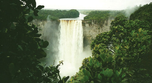
::圭亚那人口不到100万,其种族背景是非洲人(36%)、东印度人(50%)和美洲印第安人(7%)的混合体。 其余是混杂的欧洲人。 东印度人的宗教背景包括两者和。 约50%的人口已经转变为欧洲人。 族裔分裂在组织政治和社会活动方面造成了困难。 例如,一个政治关切是,经济优势更大的少数群体将在政治舞台上占据主导地位,而不考虑其他族裔群体。Most of Guyana’s people live in the coastal regions. The almost impenetrable interior has large uninhabited areas with dense tropical forests. To protect its unique biodiversity, large areas have been placed in conservation areas and national parks. More than one million acres have been placed in the to help preserve the natural environment and provide a sustainable economic relationship with local Waiwai people. In a similar effort, the government created the Kaieteur National Park, which features the spectacular Kaieteur Falls. They are about five times higher than Niagara Falls in North America. Other areas of Guyana are also being considered for preservation.
::圭亚那大部分人口居住在沿海地区,几乎无法渗透的内地有大片无人居住、热带森林稠密的地区。为了保护其独特的生物多样性,大片地区被安置在保护区和国家公园中。 超过100万英亩土地被安置在保护自然环境和与当地的Waiwai人建立可持续经济关系的地方。 同样,政府创建了Kaieteur国家公园(Kaieteur National Park ) , 其特色是壮观的Kaieteur Falls。 这些土地比北美的Niagara瀑布高出五倍左右。 圭亚那其他地区也在考虑予以保护。
Kaieteur Falls has the largest single-drop waterfall by volume in the world. A national park has been created in this area to include the falls.
::Kaieteur Falls拥有世界上规模最大的单滴瀑布,已在该地区建立了一个国家公园,以包括瀑布。Guyana's economy is based on agricultural activities and the export of extracted natural resources. Sugarcane is a main cash crop, and timber sales are increasing. Fishing is common in coastal areas. Bauxite mining has been the main mining activity, and mining of gold and other minerals has only advanced in recent years. Guyana's economy is similar to that of many islands of the Caribbean, a relationship exemplified by its membership in (the Caribbean Community). CARICOM's headquarters is located in Georgetown, the capital of Guyana.
::圭亚那的经济以农业活动和开采的自然资源出口为基础,甘蔗是主要的经济作物,木材销售量在增加,渔业在沿海地区很普遍,铝土采矿是主要采矿活动,黄金和其他矿物的开采近年来才有所进展,圭亚那的经济与加勒比许多岛屿的经济相似,圭亚那加入加勒比共同体(加勒比共同体)就是一例,加共体总部设在圭亚那首都乔治敦。
Suriname
::苏里南 苏里南 苏里南Map of Suriname
::苏里南地图
colonial name was Dutch Guiana. The name was changed when independence was granted in 1975. The cultural background of the colony is as diverse as its history. Dutch Guiana was divided between British and Dutch colonists. Slavery and plantation agriculture were introduced in the colonial period, and the harsh conditions of slavery caused many slaves to escape the plantations and live in the forests. These runaway slaves, called Maroons, eventually organized into viable independent groups. Peace treaties were finally made with the Maroons to grant them legitimate rights. After slavery was abolished, indentured servants from South Asia and the Dutch East Indies (Indonesia) were conscripted into the colony’s labor base.
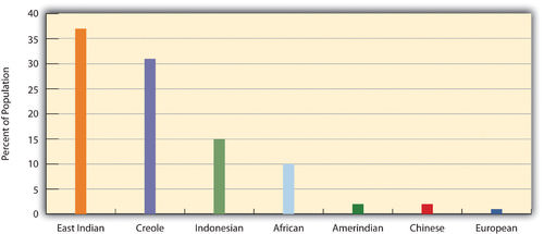
::1975年获得独立时,这个名称被更改了。这个殖民地的文化背景与其历史一样多种多样。荷兰圭亚那被英国和荷兰殖民者分割开来。奴隶制和种植园农业在殖民时期被引入,残酷的奴隶制条件导致许多奴隶逃离种植园并生活在森林中。这些逃亡的奴隶被称为马龙人,最终组织成独立团体。终于与马龙人签订了和平条约,以赋予他们合法权利。奴隶制被废除后,来自南亚和荷属东印度群岛(印度尼西亚)的契约仆人被征入该殖民地的劳动基地。Most of the half-million people who live in Suriname today live along the coast. The ethnic background of the people includes East Indian (37 percent), Creole (31 percent), Indonesian (15 percent), African (10 percent), Amerindian (2 percent), Chinese (2 percent), and European (about 1 percent). All three of the Guianas are ethnically diverse, and in this setting, diversity creates social and economic tensions. Guyana and Suriname are the least Latin regions of South America. The Creoles, for example, are mainly a mix of African and Dutch mixed with Asian or Amerindian. Establishing a stable government and conducting civil affairs are often complicated by the ethnic groups that fight for power and political control. The religious background in Suriname includes Hindu, Muslim, Christian, and a mix of African religions such as Winti.
::如今生活在苏里南的50万人中,大部分生活在苏里南,他们生活在沿岸,其族裔背景包括东印度人(37%)、克里奥尔人(31%)、印度尼西亚人(15%)、非洲人(10%)、美洲印第安人(2%)、中国人(2%)和欧洲人(约1%),所有三个圭亚那人都是族裔多样性,在这种背景下,多样性造成了社会和经济紧张。圭亚那和苏里南是南美洲拉丁美洲最少的地区。例如,克里奥尔人主要是非洲人和荷兰人混杂在一起的,他们与亚洲人或美洲印第安人混在一起。 建立稳定的政府和处理民政事务往往因争取权力和政治控制的族裔群体而变得复杂。 苏里南的宗教背景包括印度教、穆斯林教、基督教以及温蒂等非洲宗教的混合。
This graphic illustrates the ethnic groups of Suriname by percentage of the population.
::该图按人口百分比说明了苏里南的族裔群体。
Suriname depends on agriculture and natural resources as its two main economic activities. Suriname has the smallest physical area of all the independent South American states. It has a limited ability to provide opportunities and advantages for its growing population. Bauxite is the country’s main export product. In 1941, during World War II, the United States occupied the country to secure the valuable bauxite mines that were critical to the war effort. Suriname has also been expanding its gold mining, oil extraction, logging, and fishing industries. To protect its natural environment and its extensive biodiversity, the country has established national parks and created the large , which has named a . Suriname hopes to benefit from these measures to create an ecotourism market.
::苏里南是所有独立的南美国家中最小的自然区,为不断增长的人口提供机遇和优势的能力有限。 铝土土是苏里南的主要出口产品。 1941年,第二次世界大战期间,美国占领苏里南是为了保护对战争努力至关重要的宝贵铝土矿。 苏里南还一直在扩大其黄金开采、石油开采、伐木和渔业。 为了保护其自然环境和广泛的生物多样性,苏里南建立了国家公园并创建了大型公园 — — 它命名为 — — 苏里南希望从这些措施中受益,以创建一个生态旅游市场。Both Guyana and Suriname have had border disputes with their neighbors. Guyana has been locked in a challenge with over its western region, which Venezuela claimed during the colonial era. A 1905 treaty ruled in Guyana’s favor, but a small portion is still under dispute. The corner of Surname that borders Brazil and Guyana has been an issue of contention fueled by the potential for mining of gold and other minerals in the area. The maritime boundary between Suriname and Guyana is also a point of contention. Suriname’s border with French Guiana has a disputed area along the southern corner next to Brazil. These disputes emerged out of colonial agreements and poorly defined treaty boundaries.
::圭亚那和苏里南都与邻国发生边界争端。 圭亚那在殖民时代一直面临西部地区的挑战,而委内瑞拉在殖民时代就宣称了这一点。 1905年条约对圭亚那有利,但一小部分仍在争议之中。 与巴西和圭亚那接壤的苏里南角是该地区金矿和其他矿物开采潜力引发争议的一个问题。 苏里南和圭亚那之间的海上边界也是争议点。 苏里南与法属圭亚那的边界在巴西的南角有争议地区。 这些争议来自殖民协定和不明确的条约边界。French Guiana
::法属圭亚那is still a colony (department) of France. With fewer than 250,000 people in an area slightly smaller than Kentucky, this is a sparsely inhabited area. Half of the population lives in the capital city of . Most of the population is Creole, mainly a combination of African and French with various Asian groups mixed in. The people work in subsistence agriculture or for the French government. A noted feature of the colony’s heritage is the former off-shore prison on Devil’s Island, which France used to secure its most undesirable prisoners. More than 50,000 French prisoners were delivered to the Devil’s Island facility during the colonial era, but less than 10 percent survived. The prison was closed in 1951.
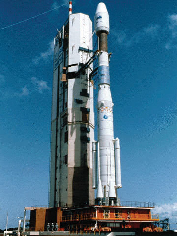
::法国的殖民地仍然是法国的殖民地(省)。在比肯塔基州略小一点的地区,人口不到25万人,这是一个人口稀少的地区。半数人口居住在首都城市。大部分人口是克里奥尔人,主要是非洲人和法国人,与各种亚洲群体混在一起。人们从事自给农业或为法国政府工作。殖民地遗产的一个显著特征是前魔鬼岛上的离岸监狱,法国用来保护最不受欢迎的囚犯。在殖民时代,有5万多法国囚犯被送到魔鬼岛设施,但存活率不到10%。 1951年,该监狱关闭。This Ariane 42P was launched from the European Space Agency’s Guiana Space Center in Kourou, French Guiana, on August 10, 1992.
::这架阿丽亚娜42P是1992年8月10日从设在法属圭亚那库鲁的欧洲航天局圭亚那航天中心发射的。
The European Space Agency maintains a launch center in French Guiana because of its favorable climate and launch conditions. France maintains the facility and has subsidized the department's economy. This European support provides the population with a higher standard of living than in many other South American countries. Economic activities have included fishing, agriculture (bananas and sugar) and logging. Deforestation from the sale of hardwood lumber has become a problem throughout the Guianas as it leaves the soil open for erosion. Logging endangers the area's fragile but extensive biodiversity. Roads, dams, and gold mining have also contributed to the erosive destruction of the environment.
::欧洲航天局由于其有利的气候和发射条件,在法属圭亚那维持了一个发射中心。法国维持了该设施并补贴了该部门的经济。欧洲的这种支持为人口提供了比其他许多南美国家更高的生活水平。经济活动包括渔业、农业(香蕉和糖)和伐木。出售硬木木材砍伐森林已成为整个圭亚那的一个问题,因为它使土壤不受侵蚀。伐木危及该地区的脆弱但广泛的生物多样性。道路、水坝和黄金开采也助长了对环境的侵蚀性破坏。Cultural Regions of South America
::南美洲文化区Colonialism changed the ethnicity, religion, language, and economic activities of the people in South America. The past 500 years have molded the current states and regions of the South American continent. To identify standards of living, ethnic majorities, and economic conditions, it is helpful to map out South America’s various cultural regions.
::殖民主义改变了南美洲人民的种族、宗教、语言和经济活动。 在过去的500年中,南美洲大陆的当前州和地区已经形成。 为了确定生活水平、族裔多数和经济状况,绘制南美洲各文化区图是有益的。In South America, five main cultural regions indicate the majority of ethnic groups and the main economic activities:
::在南美洲,五个主要文化区域显示大多数族裔群体和主要经济活动:-
Tropical Plantation (region)
::热带植物(区域) -
Rural Amerindian (region)
::美洲农村印第安人(地区) -
Amazon Basin
::亚马逊流域 -
Mixed Mestizo (region)
::混合梅斯蒂索(区域) -
European Commercial--Southern Cone (region)
::欧洲商业-南锥体(区域)
This graphic illustrates the cultural spheres of South America.
::这一图示说明了南美洲的文化领域。
These are generalized regions that provide a basic understanding of the whole continent. Technological advancements and globalization have increased the integration of the continent to the point that these regions are not as delineated as they once were, but they still provide a context in which to understand the ethnic and cultural differences that exist within the realm.
::技术进步和全球化加强了非洲大陆的一体化,以致于这些区域没有象过去那样被划定,但它们仍然提供了一个背景,使人们可以了解该地区存在的种族和文化差异。Tropical Plantation Region
::热带植物区Salvador, Brazil, is located along the coastal region of South America where the Tropical Plantation Region was prominent. Most people in this region are of African descent.
::巴西萨尔瓦多位于南美洲沿海地区,热带植物种植区很突出,该地区大部分人是非洲人后裔。
Located along the north and east coast of South America, the Tropical Plantation Region resembles the Caribbean rimland in its culture and economic activity. The region, which extends as far south as the Tropic of Capricorn, has a tropical climate and an agricultural economy. Europeans opened up this area for plantation agriculture because of coastal access for ships and trade. The local people were forced into slavery, but when the local people died or escaped, millions of African slaves were brought in to replace them. After slavery was abolished, indentured servants from Asia were brought to the Guianas to work the plantations. The Tropical Plantation Region has a high percentage of people of African or Asian descent.
::热带种植园位于南美洲北海岸和东海岸,在文化和经济活动方面与加勒比边缘地区相似,其面积远至南端的摩尔山热带,具有热带气候和农业经济,欧洲人开放这个种植区进行种植农业,因为有船只和贸易的沿海通道,当地人民被迫成为奴隶,但当当地人民死亡或逃跑时,数百万非洲奴隶被带来取代他们,奴隶制被废除后,亚洲契约仆人被带往瓜亚那斯,在种植园工作,热带种植园占非洲或亚裔人口的很大比例。Rural Amerindian Region
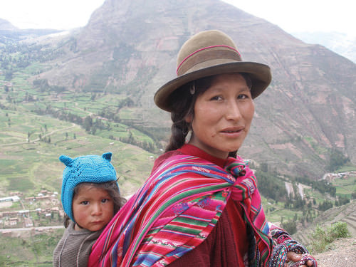
::农村美洲印第安人地区The Amerindian woman and child in this photo live in the Sacred Valley of the Andes in Peru.
::这张照片中的美洲印第安人妇女和儿童生活在秘鲁安第斯山脉的神圣谷地。The Rural Amerindian Region includes the countries of Ecuador, Peru, and Bolivia. The ruling Mestizo class that inherited control from the European conquistadors mainly lives in urban areas. Most of the rural Amerindian population lives in mountainous areas with type H climates and survives by subsistence agriculture. This is one of the poorest regions of South America, and land and politics are controlled by powerful elites. The extraction of gold and silver has not benefited the local Amerindian majority, which holds to local customs and speaks local languages.
::美洲印第安人农村地区包括厄瓜多尔、秘鲁和玻利维亚等国家,从欧洲征服者手中继承控制权的执政的梅斯蒂索阶级主要居住在城市地区,大多数美洲印第安人农村人口居住在H型山区,靠自给农业生存,这是南美洲最贫穷的地区之一,土地和政治由强权精英控制,黄金和银色的开采并没有使当地美洲印第安人占多数,他们遵守当地习俗,讲当地语言。Amazon Basin
::亚马逊流域The Amazon Basin, which is characterized by a type A climate, is the least-densely populated region of South America and is home to isolated Amerindian groups. The development has encroached upon the region in the forms of deforestation, mining, and cattle ranching. Large deposits of iron ore, along with gold and other minerals, have been found in the Amazon Basin. Preservation of the tropical rain forest of this remote region has been hampered by the destructive pattern of development that has pushed into the region. The future of the basin is unclear because of development patterns that are expected to continue as Brazil seeks to exploit its interior peripheral region. Conflicts over land claims and the autonomy of Amerindian groups are on the rise.
::亚马孙流域以A型气候为特征,是南美洲人口密度最低的地区,是孤立的美洲印第安人群体的家园;这一发展以砍伐森林、采矿和牧牛为形式侵蚀了该地区;在亚马孙流域发现了大量铁矿石矿床,以及黄金和其他矿物矿藏;保护这个偏远区域的热带雨林受到向该地区推进的破坏性发展模式的阻碍;该流域的未来尚不清楚,因为随着巴西试图开发其周边的内地,预计这种发展模式将继续下去;关于土地要求和美洲印第安人群体自治的冲突正在增加。
The Amazon has more than 1,100 tributaries.
::亚马逊有1 100多个支流。Mixed Mestizo Region
::混合梅斯蒂索地区The Mixed Mestizo Region includes the coastal area of the west and the interior highlands of the north and east. This region between the Tropical Plantation Region and the Rural Amerindian Region includes a majority of people who share a mixed European and Amerindian ethnicity. It is not as poor as the Rural Amerindian Region and yet not as wealthy as the European-dominated region to the south. falls into the Mixed Mestizo Region, as do other portions of other South American countries such as parts of Brazil, , and Venezuela. Paraguay is mainly Mestizo, but its economic qualities resemble that of the Rural Amerindian Region to the north, even though Paraguay is not located in the mountains.
::混合梅斯蒂索地区包括西部沿海地区以及北部和东部内地高原,热带种植园区与美洲印第安人农村区之间的地区包括欧洲和美洲印第安人混合族裔的多数人,其贫穷程度不如美洲印第安人农村区,但富裕程度不如以欧洲为主的南部地区,与巴西、委内瑞拉和委内瑞拉等南美洲其他国家其他地区一样,属于混合梅斯蒂索地区,巴拉圭主要是梅斯蒂索人,但其经济品质与北部美洲印第安人农村区相似,尽管巴拉圭不在山区。European Commercial Region (Southern Cone)
::欧洲商业区(南锥体)The southern part of South America, called the European Commercial Region or the Southern Cone, includes Chile, Argentina, , and parts of Brazil. European ethnic groups dominate this region and include not only Spanish and Portuguese but also German, Austrian, Italian, and other European ethnic heritages. Fertile soils and European trade provided early economic growth, and the region attracted industry and manufacturing in the later decades of the 20th century.
::南美南部被称为欧洲商业区或南锥体,包括智利、阿根廷和巴西部分地区,欧洲族裔群体在这一地区占主导地位,不仅包括西班牙语和葡萄牙语,还包括德语、奥地利语、意大利语和其他欧洲民族遗产。 肥沃的土壤和欧洲贸易提供了早期经济增长,该地区在20世纪后几十年吸引了工业和制造业。There are not many Amerindians or people of African descent here. More than 90 percent of all the people in Argentina, Chile, and Uruguay are of European descent and live in urban areas. With a highly urbanized population and with trade connections to a globalized economy, the Southern Cone is home to South America’s most developed economies.
::这里的美洲印第安人或非洲裔人并不多。 阿根廷、智利和乌拉圭90%以上的人口是欧洲裔,居住在城市地区。 人口高度城市化,与全球化经济有贸易联系,南锥体是南美最发达经济体的家园。Globalization and Trade
::全球化与贸易South America has been fragmented by European colonialism. The colonial economic patterns did not encourage the South American countries to work together to create an integrated continental trade network. Countries outside the continent have promoted trade partnerships to benefit from South America’s natural resources and agricultural exports. The establishment of the European Union and the North American Free Trade Agreement (NAFTA) created globalized trading blocs that challenged the South American countries to consider how to take advantage of trading opportunities within their realm to protect and support their own economic interests.
::南美被欧洲殖民主义分割开来。 殖民经济模式并不鼓励南美国家合作建立一个一体化的大陆贸易网络。 非洲大陆以外的国家促进了贸易伙伴关系,从南美的自然资源和农业出口中获益。 欧盟和北美自由贸易协定(NAFTA)的建立创造了全球化的贸易集团,这些集团要求南美国家考虑如何利用自身范围内的贸易机会来保护和支持自身的经济利益。Since the 1990's, cooperation and business ventures have started to form within the realm to create a more integrated network of trade and commerce to benefit the countries of South America. Transportation and communication systems are being developed through joint ventures by internal investment groups. River and road systems continue to be managed and developed for improved transport of people and goods throughout the continent. Free-trade agreements have been implemented to support the integration of internal economic networks and competition in the global marketplace.
::自1990年代以来,合作和商务企业开始在本领域内形成,以建立一个更加一体化的贸易和商业网络,使南美洲各国受益;通过内部投资集团合资发展运输和通讯系统;继续管理和发展河流和公路系统,以改善整个非洲大陆的人员和货物的运输;执行自由贸易协定,支持将国内经济网络和竞争纳入全球市场。In 2008, the South American countries formed the to oversee the customs unions and trade agreements within the realm. One of the more established trade associations is (the Southern Cone Common Market), created in 1995 by the southern countries. It has evolved to include most countries in South America and is the most dominant trade agreement in the realm. Full members of Mercosur include Argentina, Uruguay, Paraguay, and Brazil. Chile, Bolivia, Peru, Ecuador, and Colombia are associate members. As of 2011, Venezuela’s membership was under review.
::2008年,南美洲国家组成了监督本领域内关税同盟和贸易协定的机构,其中比较成熟的行业协会之一是1995年由南方国家创建的南锥体共同市场(南锥体共同市场),它已经演变为包括南美洲大多数国家,是本领域内最具支配地位的贸易协定。南锥体共同市场的正式成员包括阿根廷、乌拉圭、巴拉圭和巴西。智利、玻利维亚、秘鲁、厄瓜多尔和哥伦比亚是准成员。 截至2011年,委内瑞拉的成员资格正在审查之中。The Andean Community (Colombia, Ecuador, Peru, and Bolivia) was established in 1969 but did not gain ground until 1995, when it established stronger trade measures. Multinational corporations have supported the creation of a Free Trade Area of the Americas (FTAA) to include all of the Western Hemisphere in one unified trade association. It has not been approved and has received strong opposition from Mercosur and economic forces that support a more localized economy controlled by local people.
::安第斯共同体(哥伦比亚、厄瓜多尔、秘鲁和玻利维亚)于1969年成立,但直到1995年建立更强有力的贸易措施才有所进展,多国公司支持建立美洲自由贸易区,将西半球所有地区纳入一个统一的贸易协会,但未获批准,并受到南锥体共同市场和那些支持由当地人民控制的更本地化经济的经济力量的强烈反对。South America faced division and competition during the colonial era between the Spanish and the Portuguese. Today’s new era of corporate colonialism has created similar fragmentation and divisions. The level of trade between the countries of South America and the United States and Europe varies widely. Countries such as Colombia and Chile have well-established trade relationships with the United States and are unwilling to jeopardize those trade connections to strengthen ties with their neighbors that have less-supportive political relationships with the United States.
::南美洲在殖民时代西班牙人和葡萄牙人之间面临着分裂和竞争。 如今,新的企业殖民主义时代也造成了类似的分裂和分裂。 南美洲和美国和欧洲之间的贸易水平差异很大。 哥伦比亚和智利等国家与美国有着牢固的贸易关系,并不愿意破坏这些贸易联系,以加强与美国政治关系不那么有利的邻国的关系。External global trade arrangements often provide financial benefits to individual countries that might not be shared by the bordering countries in the same region. South America’s historical fragmentation has not made it easy to unify the continent under a singular trade agreement to complete against the European Union or NAFTA.
::外部全球贸易安排往往为个别国家带来财政利益,而同一区域的邻国可能无法分享这些利益。 南美的历史支离破碎并不容易将非洲大陆统一在一个单一的贸易协定之下,完成与欧洲联盟或北美自由贸易协定的对立。
Key Takeaways
::密钥外出-
The extensive Andes Mountain chain and the massive Amazon River dominate the realm’s physical geography.
::安第斯山脉的广阔链条和庞大的亚马逊河主宰着这个大陆的地理地理。 -
The Spanish and the Portuguese were the two main colonial powers that dominated South America.
::西班牙和葡萄牙是主宰南美洲的两个主要殖民国家。 -
The Guianas were the only part of the continent not dominated by these the Spanish and the Portuguese.
::圭亚那是非洲大陆唯一没有西班牙人和葡萄牙人统治的地区。 -
Britain, Holland, and France formed colonies in the Guianas.
::英国、荷兰和法国在圭亚那建立了殖民地。 -
The slave trade brought many people of African descent to the Guiana colonies.
::奴隶贸易将许多非洲人后裔带到圭亚那殖民地。 -
After slavery was abolished, indentured servants from Asia were brought to the Guianas to support the labor base.
::奴隶制度被废除后,亚洲契约仆人被带到圭亚那支持劳动力基础。 -
Identifying the majority of ethnic groups in South America can be helpful in classifying the various cultural regions of the realm.
::查明南美洲大多数族裔群体可以有助于对该地区各种文化区域进行分类。 -
Colonial activities and ethnic backgrounds are consistent enough to formulate regions with similar characteristics.
::殖民活动和族裔背景相当一致,足以形成具有类似特点的区域。 -
Globalization and the creation of economic or political units such as the European Union and NAFTA have prompted the South American countries to work together to implement cooperative trade agreements and create the Union of South American Nations.
::全球化以及欧洲联盟和北美自由贸易协定等经济或政治单位的建立促使南美洲国家共同努力执行合作贸易协定并创建南美洲国家联盟。
Vocabulary Terms
::词汇术语术语Chapter 4.5 South America: Physical Geography
::第4.5章 南美洲:自然地理Andes
::安第斯long mountain range that runs down the west coast of South America
::南美西海岸长山脉Atacama Desert
::阿塔卡马沙漠found in Chile, is the hottest desert on earth
::在智利发现,是地球上最热的沙漠Francisco Pizarro
::弗朗西斯科·皮萨罗Spanish conquistador who conquered the Inca
::征服印加的西班牙征服者Inca
::印加语A Mesoamerican civilization that was an empire. They lived in the Andes Mountains of South America (Ecuador, Peru, and Chile). They kept records using a complicated system of colored knotted cords called quipus. Pizarro conquered them in 1535
::中美洲文明是一个帝国,他们生活在南美洲的安第斯山脉(厄瓜多尔、秘鲁和智利),他们使用称为quipus的彩色结结绳的复杂系统保存记录。Llanos
::兰诺斯grassland located in Colombia and Venezuela
::位于哥伦比亚和委内瑞拉的草原Jose de San Martin
::何塞·德圣马丁A general who led a war for South American independence beginning in 1810. His leadership freed the southern parts of South America from Spain and Portugal
::1810年开始领导南美洲独立战争的将军,他的领导将南美洲南部从西班牙和葡萄牙解放出来。MERCOSUR
::南锥体共同市场An economic and political bloc comprising Argentina, Brazil, Paraguay, Uruguay, and Venezuela
::由阿根廷、巴西、巴拉圭、乌拉圭和委内瑞拉组成的经济和政治集团Pampas
::帕帕帕斯grassland located in Argentina and Uruguay. Known for cattle ranching
::位于阿根廷和乌拉圭的草地。Simon Bolivar
::西蒙·玻利瓦尔A general who led a war in 1810 for South American independence. His leadership freed the northern parts of South America from Spain and Portugal. He was known as "the Liberator"
::1810年领导南美洲独立战争的将军,他的领导人将南美洲北部从西班牙和葡萄牙解放出来,他被称为“解放者”。Applying Knowledge
::应用知识Interactive Notebook Activities
::互动笔记活动-
Summarize
the main physical features and characteristics of South America.
::概述了南美洲的主要物理特征和特征。 -
Explain
how European colonialism dominated the realm and divided up the continent.
::解释欧洲殖民主义如何主导整个大陆, -
Describe
the ethnic, economic, and political patterns in the Guianas.
::说明圭亚那的种族、经济和政治格局。 -
List
the main cultural realms of South America.
::列出南美洲的主要文化领域。 -
Describe
each realm’s main ethnic majority.
::说明每个地区的主要族裔多数。 -
Explain
how colonialism impacted each region.
::说明殖民主义如何影响每个区域。 -
Summarize
briefly how the South American countries are integrating their economies.
::简要概述南美洲国家如何实现经济一体化。
Discussion and Study Questions
::讨论和研究问题-
What are the two main physical features of South America? Where are they located?
::南美洲的两个主要物理特征是什么?它们在哪里? -
What two main European colonial powers dominated South America?
::哪个主要的欧洲殖民国家主宰了南美洲? -
What are the majority ethnic groups in each of the Guianas?
::每个圭亚那的多数族裔群体是什么? -
How do most people in the Guianas make a living?
::圭亚那大多数人是靠什么谋生的? -
Where are the five main cultural regions of South America?
::南美洲五个主要文化区域在哪里? -
What are the majority ethnic groups in each of the cultural regions of the continent?
::该大陆各文化区域中多数族裔群体是什么? -
Why would the Southern Cone have a stronger economic position than other regions?
::为什么南锥体的经济状况会比其他区域强? -
What are the environmental concerns in the Guianas?
::圭亚那的环境关切是什么? -
What are the main economic trade agreements for the South American countries?
::南美洲国家的主要经济贸易协定是什么? -
Why has it been so difficult to unify the countries in this realm into a single trade zone?
::为什么很难将这一领域的国家统一为一个贸易区?
Real-World Geography Exercise
::现实世界地理演习-
Using
, complete the following activities:
-
Locate each place on the bulleted list below.
::在下面的子弹名单上 找到每个地方 -
Find the nearest city with an international airport in proximity to each location on the bulleted list below.
::找到最近的城市,在下面子弹清单上每个地点附近有一个国际机场。 -
Calculate the distance and travel time by plane to each city from the
in Anchorage, Alaska.
::计算从阿拉斯加Anchorage到每个城市的距离和飞行时间。
::使用,完成以下活动: 确定以下子弹清单上的每个地点; 在下面子弹清单上的每个地点附近找到一个国际机场的最近的城市。 计算从阿拉斯加Anchorage到每个城市的飞机距离和飞行时间。 -
Locate each place on the bulleted list below.
-
Using
, determine the latitude and longitude for each location on the
bulleted
list below.
::使用,确定以下子弹列表中每个位置的纬度和经度。 -
Be prepared to share and discuss your answers.
::准备分享和讨论你的答案
-
Altiplano
::阿尔平平原 -
Amazon Basin
::亚马逊流域 -
Amazon River
::亚马逊河 -
Andes Mountains
::安第斯山脉 -
Atacama Desert
::阿塔卡马沙漠 -
Brazilian Highlands
::巴西高地 -
Cape Horn
::角角角角角角 -
Cerrado
::塞拉多 -
Devil’s Island
::魔鬼岛 -
Easter Island
::复活岛岛 -
European Commercial Region
::欧洲商业区 -
Falkland Islands
::福克兰群岛 -
Galapagos Islands
::加拉帕帕戈斯群岛 -
Guiana Highlands
::圭亚那高地 -
Guianas
::圭亚那 -
Lake Maracaibo
::马拉开波湖 -
Lake Titicaca
::提喀喀喀湖 -
Llanos
::兰诺斯 -
Madeira River
::马德拉河 -
Mato Grosso Plateau
::马托格罗索高原 -
Mixed Mestizo Region
::混合梅斯蒂索地区 -
Orinoco River
::奥里诺科河 -
Pampas
::帕帕帕斯 -
Paraguay River
::巴拉圭河 -
Paraná River
::巴拉那河 -
Patagonia
::巴塔哥尼亚 -
Rio de la Plata
::布拉普拉塔里约会议 -
Rio Negro
::里约-内格罗 -
Robinson Crusoe Island
::鲁滨逊克鲁索岛 -
Rural Amerindian Region
::农村美洲印第安人地区 -
Sao Francisco River
::旧金山河 -
Southern Cone
::南锥体 -
Tierra del Fuego
::火地岛 -
Tordesillas Line
::托德西利亚线 -
Tropical Plantation Region
::热带植物区 -
Xingu River
::兴珠河
Mapping Exercise
::绘图绘制作业ESRI GEO Inquiry
::ESRI GEGO调查: Illustrate and explore how global mountain ranges are formed in relation to plate motions.Videos for Geography Enrichment
::地理丰富视频Helpful Websites for the Study of Geography
::地理研究有用网站is an encyclopedia funded by the Canadian government covering all branches of knowledge. Their scholarly collection includes interactive materials.
::该百科全书由加拿大政府资助,涵盖所有知识分支,其学术收藏包括交互式材料。provides information on the people, history, government, economy, energy, geography, communications, transportation, military, and transnational issues for the world's entities.
::向世界各实体提供关于人民、历史、政府、经济、能源、地理、通信、运输、军事和跨国问题的资料。is a US government website where you can find federal legislation, past and present, as well as information about the US legal system.
::是一个美国政府的网站,您可以在此找到过去和现在的联邦立法以及关于美国法律制度的信息。is a government agency website that provides current news, resources, topics of interest, information about drugs, careers in the DEA, and a tip hotline.
::是一个政府机构网站,提供最新消息、资源、感兴趣的话题、毒品信息、在缉毒局的职业以及一条小费热线。is the largest library in the world and provides manuscripts, files, information, pictures, and videos.
::图书馆是世界上最大的图书馆,提供手稿、文件、信息、图片和录像。is a US government agency website that allows users to search for and retrieve satellite images of Earth.
::这是一个美国政府机构的网站,用户可以搜索和检索地球的卫星图像。is a US government website that provides historical documents, photos, records, publications, and educator resources.
::这是一个美国政府网站,提供历史文件、照片、记录、出版物和教育资源。is a US government agency website that provides weather-related information and ocean research.
::是一个提供气象信息和海洋研究的美国政府机构网站。is a website by the United States Geological Survey and other federal, state, and local agencies that deliver topographic information for the United States.
::这是美国地质调查局和其他联邦、州和地方机构为美国提供地形信息的网站。is a massive central data source and a handy way to graphically compare nations.
::是一个庞大的中央数据源,是用图形比较国家的一种方便方式。is a website that measures most locations in the world for air pollution in real time.
::是一个实时测量世界上大多数空气污染地点的网站。is a unique statistical database, which allows you to research and compare a multitude of different data on US states.
::这是一个独特的统计数据库, 使你能够研究和比较关于美国各州的多种不同数据。is an international organization founded in 1945 and made up of 193 member states. The UN maintains international peace and security, protects human rights, delivers humanitarian aid, promotes sustainable development, and upholds international law.
::联合国是一个国际组织,成立于1945年,由193个成员国组成。 联合国维护国际和平与安全,保护人权,提供人道主义援助,促进可持续发展,维护国际法。is a US government agency that provides a population clock, data, surveys, statistics, a library with information and infographics, news about the economy, and much more.
::这是一个美国政府机构,它提供人口钟、数据、调查、统计、一个拥有信息和信息资料的图书馆、关于经济的新闻,以及更多。is a US government agency website that provides scientific information about the natural hazards that threaten lives, the natural resources we rely on, the health of our ecosystems and environment, and the impacts of climate and land-use change.
::这是一个美国政府机构的网站,提供科学信息,说明威胁生命的自然危害、我们赖以生存的自然资源、生态系统和环境的健康以及气候和土地使用变化的影响。is a US government website that provides the latest presidential news, information about the budget, policy, defense, and many more topics.
::提供最新总统新闻、预算、政策、国防等资讯, 以及更多议题。is under the United Nations and provides leadership on matters critical to health, shapes the research agenda on health, and monitors the health situation and assessing health trends around the world. Their website provides information on the state of health around the world, outbreaks, current health news, and more.
::网站提供世界各地卫生状况、疫情爆发、最新卫生新闻等信息。is an intergovernmental organization that regulates international trade. The website provides information on the history of the multilateral trading system, featured videos, news and events, trade topics, and more.
::该网站提供关于多边贸易体系历史的信息、视频、新闻和事件、贸易专题等等。 -
Summarize briefly the main physical features and characteristics of South America.