7.1 西南亚:介绍王国(2天)
章节大纲
-
Chapter Challenges
::章次 挑战-
Understand three basic traits the countries of the realm shares in common.
::理解三个基本特征 共同的王国国家。 -
Outline the two cultural hearths and explain why they developed where they did.
::并解释他们为何发展到何地。 -
Describe how the people of this realm gain access to fresh water.
::说明本领域人民如何获得淡水。 -
Understand how the events of the 2011 Arab Spring have affected the realm.
::了解2011年阿拉伯之春事件对王国的影响。
Student Learning Objectives
::学生学习目标TEKS Regional Unit 07 Southwest Asia: Chapter 7.1 Introducing the Realm
::7 西南亚:第7.1章 介绍王国WG.1A Analyze the effects of physical and human geographic patterns and processes on the past and describe their impact on the present, including significant physical features and environmental conditions that influenced migration patterns and shaped the distribution of culture groups today.
::WG.1A 分析物理和人类地理模式和过程对过去的影响,并描述其对目前的影响,包括影响移徙模式并影响当今文化群体分布的重要物理特征和环境条件。WG.2A Describe the human and physical characteristics of the same regions at different periods of time to evaluate relationships between past events and current conditions.
::WG.2A 描述不同时期同一区域的人的和自然的特征,以评估过去事件与当前状况之间的关系。WG.6B Explain the processes that have caused changes in settlement patterns, including urbanization, transportation, access to and availability of resources, and economic activities.
::WG.6B 解释导致住区模式变化的进程,包括城市化、运输、获得和获得资源以及经济活动。WG.8A Compare ways that humans depend on, adapt to, and modify the physical environment, including the influences of culture and technology.
::WG.8A 比较人类依赖、适应和改变自然环境的方式,包括文化和技术的影响。WG.8C Evaluate the economic and political relationships between settlements and the environment, including sustainable development and renewable/non-renewable resources.
::WG.8C 评价住区与环境之间的经济和政治关系,包括可持续发展和可再生/不可再生资源。WG.12A Analyze how the creation, distribution, and management of key natural resources affects the location and patterns of movement of products, money, and people.
::WG.12A 分析关键自然资源的创造、分配和管理如何影响产品、货币和人员流动的地点和模式。WG.12B Evaluate the geographic and economic impact of policies related to the development, use, and scarcity of natural resources such as regulations of water.
::WG.12B 评价与自然资源开发、使用和稀缺有关的政策的地理和经济影响,如水管理条例。WG.14A Analyze current events to infer the physical and human processes that lead to the formation of boundaries and other political divisions.
::WG.14A 分析当前事件,以推断导致形成边界和其他政治分裂的物质和人类过程。WG.16C Explain ways various groups of people perceive the characteristics of their own and other cultures, places, and regions differently.
::WG.16C 解释不同群体对自身和其他文化、地方和区域特征的不同看法。WG.19C Examine the environmental, economic, and social impacts of advances in technology on agriculture and natural resources.
::WG.19C 审查技术进步对环境、经济和社会对农业和自然资源的影响。WG.21C Create and interpret different types of maps to answer geographic questions, infer relationships, and analyze change.
::WG.21C 创建和解释不同类型的地图,以回答地理问题、推断关系和分析变化。WG.22C Use geographic terminology correctly.
::WG.22C 正确使用地理术语。WG.22D Use standard grammar, spelling, sentence structure, and punctuation.
::WG.22D 使用标准语法、拼写、句子结构和标点。Southwest Asia: Introducing the Realm
::西南亚:介绍王国The countries of the realm share three key dominant traits that influence all other human activities. The first key common trait relates to the climate of the region. Though various climate types can be found in this realm, it is the dry or arid type B climate that dominates most of the physical area. Other climate types include the type H highland climate (cold temperatures at the high elevations with moderate temperatures at the bases) of the mountains of the Maghreb, Iran, or Central Asia and the more moderate type C climate in the coastal regions bordering the sea. The type C climate along the coastal Mediterranean area attracts human development and is home to many large port cities.
::该地区各国共有影响所有其他人类活动的三个主要特征,第一个主要共同特征与该区域的气候有关,尽管在这个领域可以找到各种气候类型,但大多数物理地区都以干旱或干旱的B型气候为主,其他气候类型包括马格里布、伊朗或中亚山区的H型高地气候(高海拔高地温度低温,低温低温低温,低温低温低温低温)和沿海海域的C型气候。地中海沿岸地区的C型气候吸引了人类发展,许多大型港口城市都居住在C型气候中。The overall fact is that vast areas of each region are uninhabited desert. North Africa has the largest desert in the world—the Sahara—which borders the Libyan Desert and the Nubian Desert. About one-third of the Arabian Peninsula is part of the Empty Quarter of the Rub’ al Khali (Arabian Desert). Kazakhstan, Uzbekistan, and Turkmenistan have vast regions of desert with few if any inhabitants. This aspect of the realm reveals the importance of water as a valuable natural resource. Most people in the realm are more dependent on the availability of water than on the availability of oil.
::总的事实是,每个地区的大片地区都是无人居住的沙漠。 北非是世界上最大的沙漠 — — 撒哈拉,与利比亚沙漠和努比亚沙漠接壤。 阿拉伯半岛的大约三分之一是阿拉伯沙漠(Rub al Khali)空地的一部分。 哈萨克斯坦、乌兹别克斯坦和土库曼斯坦有广阔的沙漠地区,只有很少的居民。 水是宝贵的自然资源,其重要性就在于水的重要性。 该地区大多数人更依赖水的供给,而不是石油的供给。The second trait is the religion of Islam. Most of the people in the realm are Muslims. The practice of Islam in day-to-day life takes different forms in the various divisions of the religion. The differences between the divisions have contributed to conflict or open warfare. Islam serves as more than a religion. It also acts as a strong cultural force that has historically unified or divided people. The divisive nature of the religion has often resulted in serious political confrontations within the realm between groups of different Islamic ideologies.
::第二个特征是伊斯兰教,这个领域的大多数人是穆斯林,在日常生活中,伊斯兰教在宗教的不同派别中以不同的形式信奉伊斯兰教,分歧导致冲突或公开战争,伊斯兰教的作用不仅仅是宗教,还是一种强大的文化力量,在历史上统一或分裂人民,宗教的分裂性往往导致不同伊斯兰意识形态群体之间在内部发生严重的政治对抗。Concurrently, the religion of Islam is also a unifying force that brings Muslims with similar beliefs together. Islam provides structure and consistency in daily life. The faith can provide comfort and a way of living. The holy cities of Mecca and Medina are located in Saudi Arabia. Other holy cities for other divisions of Islam include Jerusalem and the two cities holy to Shia Muslims: Karbala and Najaf in Iraq. Islam dominates the realm, but other religions are significant in various regions. Israel is a Jewish state, and Christianity is common in places from Lebanon to Egypt. There are also followers of the Baha’i faith, Zoroastrianism, and groups such as the Druze, just to name a few.
::同时,伊斯兰教也是一个团结力量,将具有类似信仰的穆斯林团结在一起。伊斯兰教提供日常生活的结构和一致性。信仰可以提供舒适和生活方式。麦加和梅迪纳这两个圣城位于沙特阿拉伯。其他伊斯兰分支的圣城包括耶路撒冷和伊拉克什叶派穆斯林的两个圣城:卡尔巴拉和纳杰夫。伊斯兰统治着整个王国,但其他地区的其他宗教也很重要。以色列是一个犹太国家,基督教在黎巴嫩到埃及的各地很常见。还有巴哈教、琐罗亚斯德教和德鲁兹等团体的信徒。The third factor that all three regions of the realm share is the availability of significant natural resources. North Africa, Southwest Asia, and Turkestan all have significant reserves of oil, natural gas, and important minerals. It stands to reason that not every country has the same reserves and that some of the countries have very few or none at all. However, in terms of how the countries gain national wealth, it is the export of oil that has dominated the economic activity as it relates to the global community.
::第三个因素是该地区所有三个区域都拥有重要的自然资源,北非、西南亚和突厥斯坦都拥有大量的石油、天然气和重要矿物储备,有理由认为,并非每个国家都拥有同样的储备,有些国家只有很少或根本没有,然而,就国家如何获得国家财富而言,与全球社会有关的经济活动主要是石油出口。This realm is a peripheral realm. The resource that the realm can offer to the core economic regions of the world is the energy to fuel their economies and maintain their high standard of living. Enormous economic profits from the sale of these resources have traditionally been held in the hands of the elite ruling leader or his clan and do not always filter down to most of the population. The control of and profits from natural resources have become the primary objectives of the countries. This fuels conflicts and armed military interventions in areas such as Iraq and Afghanistan.
::这个领域是一个边缘领域,世界核心经济区域可以提供的资源是刺激其经济和维持高生活水平的能源,这些资源的出售所产生的巨大经济利润历来掌握在精英统治领袖或其部族的手中,并不总是渗透到大多数民众手中,自然资源的控制和利润已成为各国的首要目标,这在伊拉克和阿富汗等地助长了冲突和武装军事干预。Cultural Hearths
::文化之城Availability and control of fresh water have typically resulted in the ability of humans to grow food crops and expand their cultural activities. Hunter-gatherer groups did not settle down in one area but were more nomadic because of their seasonal search for food. As humans developed the ability to grow crops and provide enough food in one place, they no longer needed to move. The earliest human settlements sprang up in what is the present-day Middle East.
::淡水的供应和控制通常导致人类有能力种植粮食作物和扩大文化活动,狩猎采集者群体不是在一个地区定居,而是由于季节性地寻找食物而更加游牧,随着人类发展了种植作物和在一个地方提供足够食物的能力,他们不再需要迁移,最早的人类住区出现在今天的中东。Early human settlements provide some indication of early urbanization patterns based on the availability or surplus of food. The shift to permanent settlements included the domestication of livestock and the production of grain crops. Fruits and vegetables were grown and harvested domestically. The activities of this era created humanity’s earliest version of the rural-to-urban shift associated with the Industrial Revolution or present development. It is theorized that the ability to grow excess food provided the time and resources for urbanization and the establishment of organized communities, which often progressed into political entities or regional empires.
::早期人类住区在一定程度上显示了以粮食供应或剩余为基础的早期城市化模式,向永久住区的转变包括家畜的本土化和粮食作物的生产。水果和蔬菜是在国内种植和收获的。这个时代的活动创造了人类最早的与工业革命或当前发展相关的农村向城市的转变。据推测,过度的粮食种植能力为城市化和有组织的社区的建立提供了时间和资源,而这些社区往往发展成为政治实体或区域帝国。It has been estimated that some of the earliest cities in the world—Jericho, for example—were first inhabited around 10,000 B.C.E. in the Middle East. In the same region, two cultural hearths provide significant historical value to the concept of human development, Mesopotamia and the Nile Valley in Egypt. Both areas were settings for the growth of human civilization and are still being examined and studied today. In Mesopotamia, a remarkable human civilization emerged along the banks of the Tigris and Euphrates Rivers in what is present-day Iraq, Syria, and southern Turkey. The climate, soils, and availability of fresh water provided the ingredients for the growth of a human civilization.
::据估计,世界上最早的一些城市——例如杰里乔——最早在中东居住着公元前10 000名左右的公元前列腺,在同一地区,两个文化传闻对人类发展的概念具有重要的历史价值,埃及的美索不达米亚和尼罗河谷,这两个地区都是人类文明发展的环境,今天仍在研究和研究之中,在美索不达米亚,在当今伊拉克、叙利亚和土耳其南部的底格里斯河和幼发拉底河沿岸出现了一个引人注目的人类文明,气候、土壤和淡水的提供为人类文明的发展提供了要素。
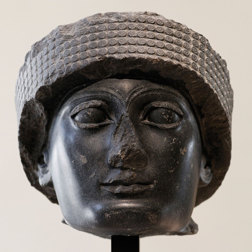
Head of Gudea, Sumerian ruler from Mesopotamia, circa 2121 B.C.E.
::来自美索不达米亚的苏美尔统治者Gudea的首领,公元前2121年Mesopotamia and the Fertile Crescent
::美索不达米亚和新月Mesopotamia , meaning “land between rivers,” is located between the Tigris and Euphrates Rivers. Neolithic pottery found there has been dated to before 7000 B.C.E. Humans in this area urbanized as early as 5000 B.C.E. People were settling in the Mesopotamia region, building magnificent cities, and developing their sense of human culture. Mesopotamia gave rise to a historical cradle of civilization that included the Assyrian, Babylonian, Sumerian, and Akkadian Empires, all established during the Bronze Age (about 3000 B.C.E. or later).
::位于底格里斯河和幼发拉底河之间的美索不达米亚(Mesopotamia ) , 意思是“河流之间的土地 ” 。 公元前7000年,发现该地区人类在公元前7000年以前就已经城市化了。 人们在美索不达米亚地区定居,建造了宏伟的城市,并发展了他们的人类文化意识。 美索不达米亚产生了一个文明的历史摇篮,包括亚述人、巴比伦人、苏美里安人和阿卡迪安帝国,它们都是在青铜时代(公元前3000年或以后)建立的。Famous cities such as Ur, Babylon, and Nineveh were located in the Mesopotamia region. The control of water and the ability to grow excess food contributed to their success. They developed extensive irrigation systems. Large grain storage units were necessary to provide the civic structure and to develop a military to protect and serve the city or empire. The human activity in this area extended around the region all the way to the Mediterranean Sea, which is where the term Fertile Crescent comes from.
::乌尔、巴比伦和尼尼微等著名城市位于美索不达米亚地区,水的控制和生产过剩粮食的能力有助于它们取得成功,它们开发了广泛的灌溉系统,需要大型粮食储存单位来提供公民结构,并发展军队来保护和服务城市或帝国,该地区的人类活动一直延伸到地中海,这里就是 " 红新月会 " 一词的起源地。
The two main cultural hearths in the realm: Mesopotamia and the Fertile Crescent in Asia and upper and lower Egypt in Africa.
::该领域的两个主要文化传道:亚洲的美索不达米亚和新月化武,以及非洲的上埃及和下埃及。
Various ancient groups were well established on the eastern side of the Fertile Crescent along the Mediterranean coast. The cities of Tyre and Sidon were ports and access points for trade and commerce for groups like the Phoenicians who traded throughout the Mediterranean. Ancient cities such as Damascus and Jericho became established in the same region and were good examples of early human urbanization during the Bronze Age. These cities are two of the oldest in the world.
::各种古代群体在地中海沿岸Fertile新月东岸早已成立,Tyre和Sidon市是地中海各地交易的Phoenicians等群体的港口和贸易和商业通道,大马士革和杰里科等古代城市也在同一地区建立起来,是青铜时代早期人类城市化的好例子,这两个城市是世界上历史最悠久的两个城市。Nile River Civilization
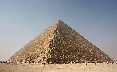
::尼罗河文明Human civilization also emerged along the Nile River valley of what is now Egypt. The pyramids and the Sphinx in the Giza Plateau just outside Cairo stand testimony to the human endeavors that took place here. Spring flooding of the Nile River brought nutrients and water to the land along the Nile Valley. The land could produce excess food, which led to the ability to support a structured, urbanized civilization. The Nile River is the lifeblood of the region.
::人类文明也出现在现在埃及所在的尼罗河谷一带,位于开罗郊外吉萨高原的金字塔和斯芬克斯证明了人类在此做出的努力,尼罗河春季洪水给尼罗河谷沿线的土地带来了营养物和水,这块土地可以产生多余的粮食,从而有能力支持结构化的城市化文明,尼罗河是该地区的生命之源。In the fifth century B.C.E., the ancient Greek historian Herodotus suggested that Egypt was “the gift of the Nile.” The dating for the beginning of the civilization along the Nile River is often in question, but Egyptologists estimate the first dynasty ruled both Upper and Lower Egypt around 3100 B.C.E. Upper Egypt is in the south and Lower Egypt is in the north because the Nile River flows north. The terms “Upper” and “Lower” refer to elevation. Geologists, using the erosion patterns of the Sphinx, estimate that it was constructed about 10,000 B.C.E.
::在公元前五世纪,古希腊历史学家希罗多图斯(Herdodotus)曾指出埃及是“尼罗河的礼物 ” 。 尼罗河沿岸文明开始的日期常常有疑问,但埃及学家估计,上埃及和下埃及的第一个王朝在公元前3100年左右统治上埃及和下埃及,上埃及在南部,下埃及在北部,因为尼罗河向北流动。“上”和“下埃及”这两个词指的是海拔。 地质学家们利用斯芬克斯的侵蚀模式估计,该王朝的建设大约在公元前10000年左右。The ability of humans to harness the potential of the environment set the stage for technological advancements that continue to this day. The Egyptian civilization flourished for thousands of years and gave birth to a legacy that influenced and benefitted their neighbors.
::人类利用环境潜力的能力为技术的进步创造了条件,直到今天。 埃及文明蓬勃发展了数千年,并产生了影响和惠及邻国的遗产。
This photo shows the Great Pyramid at Giza. Photo credit: Nina Aldin Thune
::照片来源:Nina Aldin Thune。
The human activities that created the civilizations in Mesopotamia and along Egypt’s Nile River gave humanity a rich heritage. Many of our legends, stories, and myths have their origins in these cultures. Their cultural developments provided the basis for much of the Western world’s religious beliefs and early philosophical ideas. The engineering feats needed to create the magnificent temples and pyramids have by themselves been studied and analyzed over the centuries. Scientists and scholars recognize the high level of organization and structure that went into developing and managing these civilizations.
::创造美索不达米亚文明和埃及尼罗河沿岸文明的人类活动给人类留下了丰富的遗产。 我们的许多传说、故事和神话起源于这些文化。 它们的文化发展为西方世界的许多宗教信仰和早期哲学思想提供了基础。 几个世纪以来,创建伟大神庙和金字塔所需的工程成就本身就得到了研究和分析。 科学家和学者们认识到发展和管理这些文明的组织和结构水平很高。Various aspects of science and the arts were being developed by these ancient people. Writing, mathematics, engineering, and astronomy were becoming highly advanced. Artifacts such as clay tablets and hieroglyphs are still being discovered and interpreted. They shed additional light on the advancements of these civilizations and their contribution to our human civilization.
::这些古代人正在发展科学和艺术的各个方面,写作、数学、工程学和天文学正在变得高度先进,泥土平板和象形象形文字等手工艺仍在被发现和解释,它们进一步揭示了这些文明的进步及其对人类文明的贡献。Access to Fresh Water
::获得淡水Water is one of the necessities for human existence. Human settlements have long been based on the availability of water for consumption, agriculture, navigation, and the production of energy. In North Africa and Southwest Asia, the availability of water has an even greater relevance because of the dominant type B climate. Methods used to address the shortage of water or to access fresh water have been nearly as diverse as the people who live here. Large populations of people can be found wherever there is fresh water.
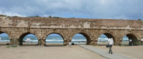
::水是人类生存的必需品之一,人类住区长期以来一直以消费、农业、航行和能源生产用水的可得性为基础,在北非和西南亚,由于主要的B型气候,水的可得性更为重要,用于解决缺水问题或获得淡水的方法几乎与居住在这里的人一样多种多样,在有淡水的地方可以找到大量人口。Water has historically been transferred from source to destination through canals, aqueducts, or special channels. Many ruins of extensive aqueducts from Roman times and earlier remain throughout the realm. The issues associated with water use continue to affect the lives of the people of this realm. Rapid population growth and industrialization have intensified the demand for fresh water.
::历史上,水源一直通过运河、水渠或特殊渠道从源头向目的地转移,罗马时代和以前许多大水渠的废墟仍留在整个国土上,与用水有关的问题继续影响着该地区人民的生活,人口迅速增长和工业化加剧了对淡水的需求。This photo shows the Roman aqueduct near Caesarea.
::这张照片展示了罗马在凯撒拉附近的水渠。
Water can be found in the desert regions in a range of forms. For example, there are oases, springs, or noted wells from which people can draw underground water that is close to the surface. Mountainous regions such as the Atlas Mountains in North Africa or the Elburz Mountains in Iran trap moisture, which produces higher quantities of precipitation. The precipitation is then available in the valleys to irrigate crops. Discovering or developing other methods of acquiring fresh water is a requirement in areas without mountains.
::沙漠地区的水有多种形式,例如绿洲、泉水或注水井,人们可以从这些水井中抽取接近地表的地下水,北非的阿特拉斯山脉或伊朗的埃尔布兹山脉等山区有水分,这些地区降水量较高,然后在河谷有降水来灌溉作物,发现或开发其他获取淡水的方法是无山区的一项要求。Underground Water in Libya
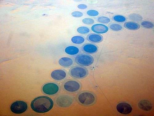
::利比亚地下水
This photo shows the Libyan pivot irrigation in Al Kufrah, southeast Cyrenaica. Wealth from oil has enabled Libya to build projects such as agriculture in the Sahara desert.
::这张照片显示了利比亚在Cyrenaica东南部Al Kufrah的支流灌溉。 石油财富使得利比亚得以在撒哈拉沙漠建设农业等项目。
In the Sahara region, Libya draws water from deep underground wells that tap into the vast aquifers beneath the desert. These aquifers were charged with water when the region had a tropical climate thousands of years ago. The water is referred to as fossil water. Extensive systems of canals and pipelines have been developed in Libya to extract fossil water and use it for agricultural production or for urban purposes. The man-made river project, one of the largest of its kind, has drawn fresh water from the desert to large cities such as Tripoli and Benghazi.
::在撒哈拉地区,利比亚从地下深水井中抽取水,钻进沙漠下的广大地下蓄水层,这些蓄水层在数千年前该地区热带气候时就装有水,水被称为化石水,利比亚开发了广泛的运河和管道系统,以提取化石水,用于农业生产或城市目的,人为河流项目是规模最大的项目之一,从沙漠向的黎波里和班加西等大城市抽取淡水。The local drinking water in Benghazi is contaminated by saltwater intrusion from the Mediterranean. Underground aquifers are underneath political boundaries, so the allocation and control of water are matters of political debate with the potential to lead to military conflict. The project’s potential duration will be a function of how quickly the water is used and how many people use the aquifer system.
::班加西的当地饮用水受到地中海海水入侵污染。 地下含水层位于政治边界下,因此水的分配和控制是政治争论的问题,可能导致军事冲突。 该项目的潜在持续时间取决于水的使用速度和有多少人使用含水层系统。The main problem with this system is that underground aquifers are not considered a renewable resource. As more countries tap into the aquifers, the available water will be depleted more quickly. As water is drawn from the aquifers for industrial irrigation, the water table goes down. Local settlements that rely on well water may in time have to dig deeper wells or move to locations where water resources are still available.
::该系统的主要问题是,地下含水层不被视为可再生资源,随着更多的国家进入含水层,可用水将更快耗尽,随着从含水层抽取水用于工业灌溉,水位下降,依赖井水的当地住区可能必须及时挖掘更深的井或搬迁到仍然有水资源的地方。Nile Water in Egypt
::埃及尼罗河水
The Aswan Dam is an embankment dam situated across the Nile River in Aswan, Egypt.
::Aswan大坝是一个堤坝,位于埃及Aswan尼罗河两岸。
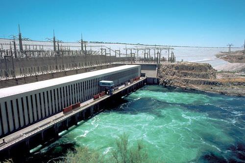
Egypt draws water from the Nile to irrigate fields for extensive food production. For thousands of years, floods of the Nile annually covered the land with fresh silt and water. This made the land productive, but the flooding often caused serious damage to human infrastructure. The building of the Aswan High Dam in the 1970s helped control the flooding of the Nile Valley. The river no longer flooded annually, and water had to be pumped onto the land.
::埃及从尼罗河中抽水灌溉农田,以进行广泛的粮食生产。 数千年来,尼罗河的洪水每年以新鲜的淤泥和水覆盖土地。 这使得土地具有生产力,但洪水往往对人的基础设施造成严重的破坏。 1970年代建造的阿斯旺高坝帮助控制了尼罗河谷的洪水。 河水不再每年淹水,水必须抽到土地上。Over time, the constant and extensive use of this type of irrigation causes the small quantities of salt in the water to build up in the soil to serious levels, thereby reducing the land’s productivity. This process, called salinization, is a common problem in arid climates. To rid the soil of the salts, fresh water is needed to flood the fields, dissolving the salt and then moving the salty water back off the fields.
::随着时间的流逝,这种灌溉的不断和广泛使用导致水中的少量盐分在土壤中积累到严重的水平,从而降低土地的生产力。 这一过程被称为盐碱化,是干旱气候中常见的问题。 为了清除盐类的土壤,需要淡水来淹没田地,将盐分解,然后将盐水从田地上移走。High salinization in the soil and the reduction in agricultural productivity is a growing concern for Egypt. Egypt’s growing population places a high demand on the availability of food. More than half of the 80 million people in Egypt live in rural areas. Many of them make their living in agriculture growing food that plays a critical role in the country’s economic stability
::埃及越来越关注土壤高度盐碱化和农业生产力下降的问题。 埃及人口不断增长,对粮食供应的需求很高。 埃及8 000万人口中有一半以上生活在农村地区。 他们中许多人以农业为生,种植粮食,对埃及经济稳定起着关键作用。Water from the Tigris and Euphrates
::来自底格里斯河和幼发拉底河的水
The Tigris is an important river for agriculture just outside Diyarbakır.
::底格里斯河是位于迪亚巴克尔郊外的一条重要的农业河流。
The major source of water in the Fertile Crescent region comes from the Tigris and Euphrates rivers. Both have their origins in Turkey and converge at the Shatt al-Arab waterway that flows into the Persian Gulf. The Euphrates is the longest river in Southwest Asia and flows through Syria from Turkey before entering into Iraq. Turkey had developed large dams on both the Tigris and Euphrates for agricultural purposes and to generate hydroelectric power.
::费尔蒂勒新月地区的主要水源来自底格里斯河和幼发拉底河,它们都起源于土耳其,汇合在流入波斯湾的阿拉伯河水道上,幼发拉底河是西南亚最长的河流,在进入伊拉克之前从叙利亚流经叙利亚,土耳其在底格里斯河和幼发拉底河上建造了大型水坝,用于农业目的和发电。As water is diverted for agriculture in Turkey, there is less water flowing downstream for Syria or Iraq. Disputes over water resources continue to be a major concern in the Tigris-Euphrates Basin. The Atatürk Dam in Turkey is largest dam on the Euphrates, and it has a reservoir behind the dam that is large enough to hold the total annual discharge of the river. All three countries have dams on the Euphrates and both Turkey and Iraq have dams on the Tigris.
::由于土耳其的水资源被转用于农业,叙利亚或伊拉克的下游水流减少,水资源争端仍然是底格里斯-幼发拉底河流域的一个主要问题。 土耳其的阿塔图尔克大坝是幼发拉底河最大的水坝,大坝后面有一个储水库,足以维持每年全部河流排放。 这三个国家都有幼发拉底河沿岸的水坝,土耳其和伊拉克在底格里斯河沿岸都有水坝。The three countries signed a memorandum of understanding in 2009 to strengthen cooperation within the Tigris-Euphrates Basin. All three countries need water for agriculture to produce food for a growing population. Agreements to share water have been difficult as a result of the Iraq War and the recent protests and demonstrations in Syria that have contributed to further political tension between the three countries.
::三国于2009年签署了一项谅解备忘录,以加强底格里斯-幼发拉底河流域内部的合作,这三个国家都需要农业用水,为不断增长的人口生产粮食,由于伊拉克战争以及叙利亚最近的抗议和示威活动,分享水的协议一直困难重重,这加剧了三国之间的政治紧张局势。Water Conservation in Israel
::以色列的水资源养护Israel has taken innovative steps to conserve water and use it efficiently. Drip irrigation mixed with fertilizers is called fertigation. Fertigation is used extensively in the area. Israel grows plantation crops such as bananas, which require large quantities of water. Banana groves are covered with material that allows sunlight to penetrate but reduces the amount of transpiration, which conserves water.
::以色列已采取创新步骤节水和有效利用水,与肥料混合的滴灌称为肥料肥料,在该地区广泛使用肥料,以色列种植香蕉等需要大量水的种植作物,香蕉林覆盖材料,使阳光能够穿透,但减少水的抽水量,节约水量。Israel has worked to recycle water whenever possible. Gray water is water extracted from sewage that has been treated to be used in agriculture. Underground wells in the West Bank region provide water for a high percentage of people in both the Palestinian areas and Israel. The issue of control over the water is contentious at times. Just as the control of water may have been an important factor in the early Mesopotamian civilizations, it remains a point of political conflict in places such as Israel and the West Bank.
::以色列努力尽可能对水进行回收处理,灰水是从污水中抽取的水,这些污水已被处理用于农业,西岸地区的地下井为巴勒斯坦和以色列地区的高比例人民提供水,对水的控制问题有时有争议,水的控制可能是早期梅索波塔米亚文明中的一个重要因素,同样,它仍然是以色列和西岸等地政治冲突的一个点。The lack of fresh water and the heavier demand placed on water resources have caused countries that can afford it to desalinize seawater. This process is used extensively in the oil-rich states of the Arabian Peninsula. Israel is implementing a similar plan to accommodate its increasing population and fresh water requirements.
::缺乏淡水和对水资源的需求增加,导致有能力的国家对海水进行淡化,这一进程在阿拉伯半岛石油丰富的国家得到广泛利用,以色列正在执行类似的计划,以满足其不断增加的人口和淡水需求。This banana grove in Israel near the Lebanese border is covered with material that allows sunlight to penetrate but helps reduce the loss of water through transpiration.
::以色列境内靠近黎巴嫩边界的香蕉园中,有材料可以穿透阳光,但有助于通过抽水减少水的流失。Mountain Water in Iran
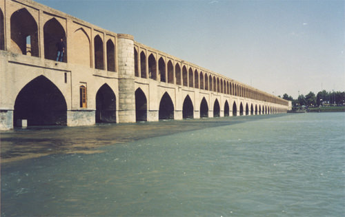
::伊朗山区水The Zayandeh River as it passes under the bridge in Isfahan, Iran.
::伊朗伊斯法罕桥下行经的扎扬德河。
Iran is largely a desert climate. Thus, most of the country does not receive large amounts of precipitation. In an effort to redistribute the water available from the high mountains, Iranians have developed a system of qanats to collect water where it is available and channel it to the cities or urban areas for use. A qanat might include a system of shafts or wells along a mountain slope that allows water to collect into a common underground channel, which is then diverted to wherever it is needed.
::伊朗基本上是一个沙漠气候,因此,该国大部分地区没有大量降水,为了重新分配高山可用水,伊朗开发了一个qanat系统,在有可用水的地方收集水,并将其输送到城市或城市地区使用。 Qanat系统可能包括沿山坡的井井系统,使水能够收集到一个共同的地下通道,然后被转移到需要的地方。This system has been in use since ancient times in many arid regions of the realm and around the world. More than 2,700 years ago, a qanat was developed in what is present-day Iran. The qanat has a system of hundreds of wells and channels water for more than 28 miles. It still provides drinking water to more than 40,000 people in the city of Gonabad. Thousands of qanats were developed over the centuries in this area. Persians used cold qanat water from the mountains to keep ice cool during the summer months. Agricultural production relies heavily on water from qanats, which are dependent on climate conditions and local weather patterns.
::自古以来,这个系统就一直用于本王国的许多干旱地区和世界各地的干旱地区,2 700多年前,在当今的伊朗开发了一座加纳特。加纳特拥有数百口水井和水道系统,水量超过28英里。它仍然为戈纳巴德市的40 000多人提供饮用水。该地区几百年来发展了数千座加纳特。波斯人利用山区冷的加纳特水保持夏季几个月的冰冷。农业生产严重依赖依赖依赖气候条件和当地天气模式的加纳特水的加纳特水。Water Shortages in Arabia
::沙特阿拉伯缺水情况
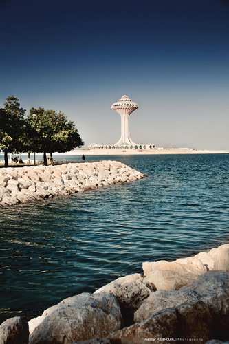
This photo shows the Khobar Water Tower in Saudi Arabia.
::这张照片展示了沙特阿拉伯的Khobar水塔。
The Arabian Peninsula has underground aquifers of fossil water located beneath the sands like the ones in the Sahara Desert. Saudi Arabia taps into these water resources to irrigate agricultural land to grow food. This area faces the same issue as Libya and other areas of the world that rely on underground aquifers. Eventually, the water supply will be used up. The majority of the Arabian Peninsula is desert and water is always in short supply.
::阿拉伯半岛的地下地下地下地下地下地下有化石水蓄水层,位于沙丘之下,如撒哈拉沙漠中的沙丘。沙特阿拉伯利用这些水资源灌溉农田以种植粮食。该地区面临着与利比亚和世界上其他依赖地下蓄水层的地区相同的问题。最终,水供应将被耗尽。阿拉伯半岛大部分是沙漠,水总是短缺。Many coastal desert countries such as the United Arab Emirates (UAE), Bahrain, and Qatar utilize the desalinization process of seawater for their needs. However, this works only as long as the country can afford the energy cost required to operate the desalinization plants.
::许多沿海沙漠国家,如阿拉伯联合酋长国(阿联酋)、巴林和卡塔尔,利用海水淡化过程来满足其需要,但是,只有国家能够承担操作淡化工厂所需的能源成本,才能做到这一点。Yemen is a state on the Arabian Peninsula that is mountainous and has used terraced farming to benefit from the precipitation they receive. Water from precipitation is trapped in terraces, and as it flows down the mountainside, each terrace uses what it needs and then passes the water to the next lower terrace. More land can be farmed to produce higher yields of agricultural crops such as sorghum and cereals.
::也门是阿拉伯半岛上的一个多山国家,利用梯田耕作来从降水中获益,降水的水被困在梯田中,随着水流向山坡,每个梯田都使用它所需要的水,然后将水输送到下一层梯田,可以耕种更多的土地,以生产高梁和谷类等农业作物的更高产量。One of the main problems with Yemen’s terrace system is that most of its trees are being cut down for firewood. Tree roots are essential for holding the soil together on the fragile mountain slopes. Another problem is heavy rains that cause serious erosion and damage to the terrace system. Additionally, the extremely rapid growth rate of Yemen’s population is outstripping its agricultural production.
::也门梯田系统的主要问题之一是大部分树木被砍为木柴。 树根对于将土壤放在脆弱的山坡上至关重要。 另一个问题是暴雨,这造成了严重的侵蚀和对梯田系统的破坏。 此外,也门人口的快速增长率超过了农业生产。Diversion of Water in Turkestan
::Turkestan地区水的转用Fresh water is in short supply in many of the desert regions of Turkestan in Central Asia. Agricultural production has traditionally been dependent on water flowing in rivers and streams that originated with the precipitation from the mountains. As humans have developed canals and irrigation systems, water from rivers has been diverted for agricultural use. Vast fields of cash crops such as cotton were developed during the Soviet era and the result had devastating consequences for the Aral Sea, which depended on the water. More than one-half of the population of Central Asia depends on agriculture for their livelihood. The other half requires water and food for their existence.
::在中亚的突厥斯坦许多沙漠地区,淡水短缺,农业生产历来依赖河流和河流的水流,这些河流和溪流源于山区的降水,随着人类开发运河和灌溉系统,河流水被转用于农业用途,如棉花等大量经济作物在苏维埃时代开发,结果对依赖水的咸海造成灾难性后果,中亚一半以上的人口依靠农业维持生计,另一半则需要水和粮食才能生存。
This map illustrates the precipitation patterns for North Africa and Southwest Asia.
::本图说明了北非和西南亚的降水模式。Arab Spring of 2011
::2011年阿拉伯之春The year 2011 brought about important changes for the human geography in parts of this realm. Citizens began to speak out against conditions in their country and actively protest against their governments. North Africa, the Middle East, and the Arabian Peninsula experienced the highest levels of protests and insurgency. Political leaders who had been in power for long periods were challenged and removed from office.
::2011年,部分地区人类地理发生了重大变化。 公民开始公开反对国家条件并积极抗议政府。 北非、中东和阿拉伯半岛经历了最高水平的抗议和叛乱。 长期执政的政治领导人受到挑战并被解职。Democratic reforms were requested or demanded by citizens seeking more individual freedom and greater access to political power. Uprisings in some of the countries were internal; other countries received external support or intervention. Overall, demonstrations, protests, and outright revolution involved millions of people desiring improved living conditions and a better future for themselves and their families.
::公民要求或要求民主改革是为了寻求更多的个人自由和更多获得政治权力的机会。 一些国家的起义是内部的;其他国家则得到外部支持或干预。 总的来说,示威、抗议和直接革命涉及数百万人,他们希望改善生活条件,为自己和家人创造更美好的未来。Protests emerged in North Africa at the beginning of 2011. Tunisia was the first country in which leadership felt the impact of civil resistance and open revolution. In January, the Tunisian president of more than 23 years was forced to flee to Saudi Arabia. In Egypt, millions of protesters demonstrated in the streets against political corruption and the lack of reforms. The revolution of Egypt’s citizens was not an armed conflict. However, it was an effective protest because it eventually brought about the ousting of President Hosni Mubarak, who had been in office for almost 30 years.
::2011年初,北非爆发了抗议活动。 2011年初,突尼斯是首个领导人感受到民间抵抗和公开革命影响的国家。 1月,超过23年的突尼斯总统被迫逃往沙特阿拉伯。 在埃及,数百万抗议者在街头示威反对政治腐败和缺乏改革。 埃及公民革命不是武装冲突。 然而,这是一场有效的抗议,因为它最终导致了胡斯尼·穆巴拉克总统的下台,而穆巴拉克总统已经执政了近30年。Demonstrations and protests continued against governments in Morocco and Algeria. Citizens voiced their concerns about social problems such as high unemployment, poor living conditions, and government corruption. Libya’s protests erupted into a full-scale armed revolution as anti-government rebels took control of the city of Benghazi in an attempt to topple Muammar Gadhafi’s 42 years of authoritarian control of the government, oil revenues, and the people. The armed Libyan revolution was eventually successful in taking control of Tripoli and in removing Gadhafi and his family from power. The revolution in Libya was aided by the North Atlantic Treaty Organization (NATO) air strikes and the implementation of a no-fly zone over the country.
::摩洛哥和阿尔及利亚政府继续遭到示威和抗议。 公民表达了他们对高失业率、恶劣生活条件和政府腐败等社会问题的关切。 利比亚的抗议爆发成为一场全面武装革命,因为反政府叛乱分子控制班加西市,企图推翻穆阿迈尔·格扎菲42年来对政府、石油收入和人民的专制控制。 利比亚的武装革命最终成功地控制了的黎波里,并解除了格扎菲及其家人的权力。 北大西洋公约组织(北约)空袭和在利比亚实施禁飞区为利比亚革命提供了帮助。The ripple effect that the Tunisian revolution had on North Africa was felt on the Arabian Peninsula in places such as Yemen and Bahrain. Mass public demonstrations in Yemen over government corruption, economic conditions, and high unemployment escalated into serious armed conflicts between government troops and opposition factions that wanted the president removed from office. In Bahrain, the protests and demonstrations were centered on the request for more personal freedoms and a greater role in leadership for the Shia population, who experienced discrimination by the Sunni-dominated government. Protests also occurred in Oman for greater reforms.
::突尼斯革命对北非的连锁效应在也门和巴林等阿拉伯半岛感受到了阿拉伯半岛的连锁效应。 在也门和巴林等地,关于政府腐败、经济状况和高失业率的大规模公众示威在也门升级为政府军和希望总统被免职的反对派之间的严重武装冲突。 在巴林,抗议和示威的核心是要求更多的个人自由和什叶派人民在领导中扮演更大的角色,他们遭受逊尼派统治政府的歧视。 在阿曼,也出现了争取更大改革的抗议。The Middle East did not escape the Arab Spring of 2011. Protests in Jordan forced King Abdullah II to reorganize his government. Israel and Lebanon were not as affected, as they had been addressing many of these issues on an ongoing basis. The country experiencing the greatest impact was Syria. Major mass demonstrations and serious protests against the government were staged in a number of cities across the country.
::中东没有逃脱2011年阿拉伯之春的阿拉伯之春,约旦的抗议迫使国王阿卜杜拉二世重组政府。 以色列和黎巴嫩没有像持续解决许多问题那样受到影响。 遭受影响最大的国家是叙利亚。 针对政府的重大大规模示威和严重抗议活动在全国一些城市中举行。In Syria, the long-term leadership of an Alawite minority continues to run the government and control the military. The al-Assad family—a father and then his son—has ruled Syria since 1971. The Syrian government has cracked down on the revolution with hard-line measures aimed at putting down the protests and demonstrations. By September 2011, more than 2,000 protesters had been killed in Syria. Many more were detained or tortured. Countless others have tried to flee to neighboring countries for their safety. The protesters in Syria want democratic reforms as well as the end of the al-Assad family reign.
::在叙利亚,一个阿拉维派少数派的长期领导人继续领导政府并控制军队。阿萨德家族 — — 父亲和儿子 — — 自1971年以来一直统治叙利亚。叙利亚政府采取强硬措施镇压革命,旨在镇压抗议和示威。 到2011年9月,叙利亚有2 000多名抗议者被杀害。更多的人遭到拘留或酷刑。无数其他人试图逃到邻国寻求安全。叙利亚的抗议者希望民主改革以及阿萨德家族统治的结束。Other parts of the realm also felt the effects of the Arab Spring of 2011 with mixed results. Iran has had similar protests and demonstrations in past years, but there was not a major revolution or uprising as a direct result of the Arab Spring. Iran is not an Arab country but has experienced ongoing political friction between citizen factions and the government. The wars in Iraq and Afghanistan have tempered or isolated internal protests or revolutionary activities in those countries even though armed conflicts continue.
::该地区其他部分也感受到了2011年阿拉伯之春的影响,其结果喜忧参半。 伊朗在过去几年中也经历了类似的抗议和示威,但阿拉伯之春并没有直接导致一场重大革命或起义。 伊朗不是一个阿拉伯国家,但公民派别与政府之间正在经历政治摩擦。 伊拉克和阿富汗的战争缓和或孤立了这两个国家的内部抗议或革命活动,尽管武装冲突仍在继续。Various Central Asian states have been working through similar issues but either has not had mass demonstrations or have not received the attention of news media regarding their situations. The wave of change that swept over the realm in the Arab Spring of 2011 is an example of how centripetal and centrifugal cultural forces act on a state or region. The political landscape was altered or drastically changed in many countries. The impact of these changes will be realized in the years and decades to come.
::中亚各国一直致力于解决类似的问题,但要么没有大规模示威,要么没有得到新闻媒体对其状况的关注。 2011年阿拉伯之春席卷世界的变革浪潮就是一例,表明一个州或一个地区是如何运作的。 许多国家的政治局势已经发生改变或急剧改变。 这些变化的影响将在今后的岁月和几十年里实现。
Key Takeaways
::密钥外出-
The realm of North Africa and Southwest Asia extends from the Atlantic Ocean along the Moroccan coast to the western border of China. It includes the regions of North Africa, Southwest Asia, and Central Asia (often referred to as Turkestan).
::北非和西南亚地区从大西洋沿摩洛哥海岸延伸到中国西部边界,包括北非、西南亚和中亚地区(通常称为突厥斯坦)。 -
Three basic features that dominate this realm include the arid type B climates, Islam as the predominant religion, and the export of petroleum and minerals to gain wealth. There are exceptions to all three features, but these three are found within most countries of the realm.
::支配这个领域的三大基本特征包括干旱的B型气候、以伊斯兰教为主的宗教、石油和矿物出口以获取财富。 这三大特征都存在例外,但三大特征存在于这个领域的大多数国家。 -
The two main cultural hearths in this realm are located along the rivers in Mesopotamia and in Egypt. Control of and access to water resources to grow excess food were the basis for the success of the empires that flourished in these two areas.
::这个领域的两个主要文化之道位于美索不达米亚和埃及的河流沿线,控制和获得水资源以种植多余的粮食是这两个地区蓬勃发展的帝国取得成功的基础。 -
Fresh water is a valuable resource that is not always available in North Africa and Southwest Asia because of the climate and physical geography. Each region within the realm has developed its own methods to draw from or extract the valuable resource of fresh water.
::淡水是一种宝贵的资源,由于气候和地理条件,北非和西南亚并非总能获得这种资源,本领域内的每个区域都制定了自己的方法,利用或提取宝贵的淡水资源。 -
The Arab Spring of 2011 was a massive wave of protests and demonstrations by citizens of the realm against their governments over such issues as poor living conditions, high unemployment, government corruption, and the lack of democratic reforms. Various leaders were removed from office and governments were pressed to reform their power structures to allow for more shared governance and reduced political corruption.
::2011年的阿拉伯之春(Arab Spring of 2011)是叙利亚王国公民反对政府抗议和示威的大规模浪潮,抗议和示威涉及生活条件恶劣、失业率高、政府腐败和缺乏民主改革等问题。 各种领导人被撤职,政府被迫改革权力结构,以便实现更共同的治理和减少政治腐败。
Vocabulary Terms
::词汇术语术语Chapter 7.1 Introducing the Realm
::第7.1章 介绍王国Anatolian Peninsula
::安纳托利亚半岛The location of Turkey. It is located the Black and Mediterranean Seas.
::土耳其位于黑海和地中海。土耳其位于黑海和地中海。Arabian Peninsula
::阿拉伯半岛A distinctive landform in southwest Asia and the largest peninsula in the world, it is separated from Africa by the Red Sea and from Asia by the Persian Gulf.
::西南亚和世界上最大的半岛具有独特的陆地形态,红海将它与非洲隔开,波斯湾将它与亚洲隔开。Atlas Mountains
::阿特拉斯山脉Run across northwestern Africa, spanning Morocco, Algeria, and Tunisia, separating the Atlantic and Mediterranean coastline from the Sahara Desert. Rich in natural resources such as iron ore, lead ore, copper, silver, mercury, rock salt, phosphate, marble, anthracite coal, and natural gas among other resources.
::横跨非洲西北部,横跨摩洛哥、阿尔及利亚和突尼斯,将大西洋和地中海海岸线与撒哈拉沙漠分隔开来。 拥有丰富的自然资源,如铁矿石、铅矿石、铜、银、汞、岩盐、磷酸盐、大理石、炭煤和天然气等。Caspian Sea
::里里海The largest inland sea in the world it is also a salt water lake located between Europe and Asia.
::世界上最大的内陆海也是位于欧洲和亚洲之间的盐水湖。Dead Sea
::死海A salt lake bordered by Jordan to the east and Israel and Palestine to the west. One of the world's saltiest bodies of water.
::东面与约旦接壤的盐湖,西面与以色列和巴勒斯坦接壤,是世界上最咸的水体之一。Euphrates River
::幼发拉底河The longest and one of the most historically important rivers of Western Asia. Together with the Tigris, it is one of the two defining rivers of Mesopotamia.
::这是西亚历时最长、也是历史上最重要的河流之一。 与底格里斯河一起,它是美索不达米亚两条决定性河流之一。oasis
::绿洲A fertile spot in the desert where water is found.
::在沙漠中一个肥沃的地方,那里有水源。Persian Gulf
::波斯湾Lies between Iran to the northeast and the Arabian Peninsula to the southwest. It has the world's largest single source of crude oil.
::伊朗东北和西南阿拉伯半岛之间的边界,是世界上最大的原油单一来源。Rub’ al-Khali
::鲁布·哈利Also known as the Empty Quarter, it is the largest contiguous sand desert in the world. Located in Southern Southwest Asia, it is the most oil-rich site in the world.
::这是世界上最大的毗连沙沙漠,位于西南亚,是世界上石油最丰富的地区。Strait of Hormuz
::霍尔木兹海峡A narrow passageway leading from the Arabian Sea to the Persian Gulf and connects the Persian Gulf to the Indian Ocean. It provides the only sea passage from the Persian Gulf to the open ocean and is one of the world's most strategically important choke points.
::这条狭窄的通道从阿拉伯海通往波斯湾,将波斯湾与印度洋连接起来,从波斯湾通往开阔海洋的唯一海上通道是波斯湾通往开阔海洋,也是世界上最具战略重要性的阻塞点之一。Suez Canal
::苏伊士运河It is an artificial sea-level waterway that connects the Mediterranean Sea and the Red Sea. The canal separates the African continent from Asia, and it provides the shortest maritime route between Europe and the lands lying around the Indian and western Pacific oceans. It is one of the world's most heavily used shipping lanes.
::它是连接地中海和红海的人工海平面水道,运河将非洲大陆与亚洲分隔开来,提供了欧洲与印度和西太平洋周围陆地之间最短的海洋航线,是世界上使用量最大的航道之一。Tigris River
::底格里斯河The eastern member of the two great rivers that define Mesopotamia, the other being the Euphrates. The river flows south from the mountains of southeastern Turkey through Iraq and empties itself into the Persian Gulf.
::地中海两条大河的东部成员,另一条是幼发拉底河,河流从土耳其东南部山区向南流经伊拉克,流入波斯湾。Monotheism
::~ ~ ~ ~ ~ ~ ~ ~ ~ ~ ~ ~ ~ ~ ~ ~ ~ ~ ~ ~ ~ ~ ~ ~ ~ ~ ~ ~ ~ ~ ~ ~ ~ ~ ~ ~ ~ ~ ~ ~ ~ ~ ~ ~ ~ ~Belief in one god.
::对一个神的信仰Desalinization
::脱盐The process of removing salt from seawater.
::从海水中去除盐的过程。Border
::边境边境边境边境边境The line that indicates the end of a territory.
::标明领土尽头的线条。Tenets
::入网线Basic principles adopted by a group.
::一组国家通过的基本原则。Applying Knowledge
::应用知识Discussion and Study Questions
::讨论和研究问题-
Why does this realm include parts of three continents?
::为什么这个领域包括三大洲的一部分? -
Which countries have territory on more than one continent?
::在不止一个大陆上,哪些国家拥有领土? -
What common traits are shared by most people in this realm?
::大部分人在这一领域具有哪些共同特征? -
What might have prompted the first rural-to-urban shift for human settlements?
::是什么促使人类住区在农村向城市的第一次转变? -
Why is the Middle East called by that term? What is it in the “middle” of?
::中东为何被这个术语称为中东?它“中”中是什么? -
What did the two cultural hearths contribute to the advancement of human culture?
::这两种文化的传闻对促进人类文化有何贡献? -
Why did the cultural hearths develop where they did?
::为什么文化灵听器会发展到哪里去呢? -
What are some of the methods Israel has used to address its fresh water requirements?
::以色列用哪些方法来满足其淡水需求? -
What prompted the Arab Spring of 2011? Which country was the first to see change?
::2011年的阿拉伯之春是什么推动的?哪个国家是第一个看到变化的国家? -
What were some of the common issues that people protested across the realm?
::哪些是人们在全境内抗议的共同问题?
Real-World Geography Exercise
::现实世界地理演习Using , locate the places on the list below. Calculate how long it would take to travel in an airplane from El Paso, Texas to the nearest big city of your choice in the vicinity of each location. Be prepared to share your answers.
::使用 , 定位下面列表中的位置。 计算从得克萨斯州埃尔帕索飞往您选择的附近大城市的飞机需要多长时间。 准备分享您的答复 。-
Arabian Peninsula
::阿拉伯半岛 -
Asia Minor
::亚 亚 小亚小亚小亚小亚小亚小亚小亚小亚小亚小亚小亚 -
Atlas Mountains
::阿特拉斯山脉 -
Elburz Mountains
::Elburz山 -
Empty Quarter
::空季度 -
Euphrates River
::幼发拉底河 -
Fertile Crescent
::肥沃新月 -
Giza Plateau
::吉萨高原 -
Levant
::收入 -
Libyan Desert
::利比亚沙漠 -
Mesopotamia
::美索不达米亚 -
Middle East
::中东中东中东 -
Nile River
::尼罗河 -
Nubian Desert
::努比亚沙漠 -
Tigris River
::底格里斯河 -
Turkestan
::突厥人
Current Events
::当前事件World Conflicts
::世界冲突Geography Videos for Enrichment
::用于浓缩的地理录像Helpful Websites for the Study of Geography
::地理研究有用网站is an encyclopedia funded by the Canadian government covering all branches of knowledge. Their scholarly collection includes interactive materials.
::该百科全书由加拿大政府资助,涵盖所有知识分支,其学术收藏包括交互式材料。provides information on the people, history, government, economy, energy, geography, communications, transportation, military, and transnational issues for the world's entities.
::向世界各实体提供关于人民、历史、政府、经济、能源、地理、通信、运输、军事和跨国问题的资料。is a US government website where you can find federal legislation, past and present, as well as information about the US legal system.
::是一个美国政府的网站,您可以在此找到过去和现在的联邦立法以及关于美国法律制度的信息。is a government agency website that provides current news, resources, topics of interest, information about drugs, careers in the DEA, and a tip hotline.
::是一个政府机构网站,提供最新消息、资源、感兴趣的话题、毒品信息、在缉毒局的职业以及一条小费热线。is the largest library in the world and provides manuscripts, files, information, pictures, and videos.
::图书馆是世界上最大的图书馆,提供手稿、文件、信息、图片和录像。is a US government agency website that allows users to search for and retrieve satellite images of Earth.
::这是一个美国政府机构的网站,用户可以搜索和检索地球的卫星图像。is a US government website that provides historical documents, photos, records, publications, and educator resources.
::这是一个美国政府网站,提供历史文件、照片、记录、出版物和教育资源。is a US government agency website that provides weather-related information and ocean research.
::是一个提供气象信息和海洋研究的美国政府机构网站。is a website by the United States Geological Survey and other federal, state, and local agencies that delivers topographic information for the United States.
::这是美国地质调查局和其他联邦、州和地方机构为美国提供地形信息的网站。is a massive central data source and a handy way to graphically compare nations.
::是一个庞大的中央数据源,是用图形比较国家的一种方便方式。is a website that measures most locations in the world for air pollution in real time.
::是一个实时测量世界上大多数空气污染地点的网站。is a unique statistical database which allows you to research and compare a multitude of different data on US states.
::这是一个独特的统计数据库, 使你能够研究和比较关于美国各州的多种不同数据。is an international organization founded in 1945 and made up of 193 member states. The UN maintains international peace and security, protects human rights, delivers humanitarian aid, promotes sustainable development, and upholds international law.
::联合国是一个国际组织,成立于1945年,由193个成员国组成。 联合国维护国际和平与安全,保护人权,提供人道主义援助,促进可持续发展,维护国际法。is a US government agency that provides a population clock, data, surveys, statistics, a library with information and infographics, news about the economy, and much more.
::这是一个美国政府机构,它提供人口钟、数据、调查、统计、一个拥有信息和信息资料的图书馆、关于经济的新闻,以及更多。is a US government agency website that provides scientific information about the natural hazards that threaten lives, the natural resources we rely on, the health of our ecosystems and environment, and the impacts of climate and land-use change.
::这是一个美国政府机构的网站,提供科学信息,说明威胁生命的自然危害、我们赖以生存的自然资源、生态系统和环境的健康以及气候和土地使用变化的影响。is a US government website that provides the latest presidential news, information about the budget, policy, defense, and many more topics.
::提供最新总统新闻、预算、政策、国防等资讯, 以及更多议题。is under the United Nations and provides leadership on matters critical to health; shapes the research agenda on health; and monitors the health situation and assessing health trends around the world. Their website provides information on the state of health around the world, outbreaks, current health news, and more.
::他们的网站提供世界各地卫生状况、疫情爆发、最新卫生新闻等信息。is an intergovernmental organization that regulates international trade. The website provides information on the history of the multilateral trading system, featured videos, news and events, trade topics, and more.
::该网站提供关于多边贸易体系历史的信息、视频、新闻和事件、贸易专题等等。 -
Understand three basic traits the countries of the realm shares in common.