9.2 南亚:周边国家(2天)
章节大纲
-
Chapter Challenges
::章次 挑战-
Outline the main physical features of the countries described in this section.
::概述本节所述各国的主要自然特征。 -
Understand how cultural differences in religion and ethnicity continue to cause conflict and division in South Asian countries and regions.
::了解在南亚国家和地区,宗教和族裔的文化差异如何继续造成冲突和分裂。 -
Outline how and why Kashmir is divided and its importance for the region.
::概述克什米尔如何和为什么分裂及其对该区域的重要性。 -
Describe how tourism has been a means of gaining wealth for the listed countries.
::说明旅游业如何成为名单所列国家获取财富的手段。 -
Summarize the main environmental concerns that are apparent in each of the countries.
::总结了每个国家所明显的主要环境问题。
Student Learning Objectives
::学生学习目标TEKS Regional Unit 09 South Asia: Chapter 9.2 The Peripheral States
::TEKS 区域股 09 南亚:第9.2章WG.1A Analyze the effects of physical and human geographic patterns and processes on the past and describe their impact on the present, including significant physical features and environmental conditions that influenced migration patterns and shaped the distribution of culture groups today.
::WG.1A 分析物理和人类地理模式和过程对过去的影响,并描述其对目前的影响,包括影响移徙模式并影响当今文化群体分布的重要物理特征和环境条件。WG.2A Describe the human and physical characteristics of the same regions at different periods of time to evaluate relationships between past events and current conditions.
::WG.2A 描述不同时期同一区域的人的和自然的特征,以评估过去事件与当前状况之间的关系。WG.5A Analyze how the character of a place is related to its political, economic, social, and cultural elements.
::WG.5A 分析一个地方的特性如何与其政治、经济、社会和文化因素相关。WG.6A Locate and describe human and physical features that influence the size and distribution of settlements.
::WG.6A 确定并描述影响定居点规模和分布的人文和物理特征。WG.11A Understand the connections between levels of development and economic activities (primary, secondary, tertiary, and quaternary).
::WG.11A 了解发展水平与经济活动(初等、中等、高等教育和四年级)之间的联系。WG.13A Interpret maps to explain the division of land, including man-made and natural borders, into separate political units such as cities, states, or countries.
::WG.13A 解释地图,解释土地划分,包括人造边界和自然边界,分为不同的政治单位,如城市、州或国家。WG.14A Analyze current events to infer the physical and human processes that lead to the formation of boundaries and other political divisions.
::WG.14A 分析当前事件,以推断导致形成边界和其他政治分裂的物质和人类过程。WG.14C Analyze the human and physical factors that influence the power to control territory and resources, create conflict/war, and impact international political relations of sovereign nations.
::WG.14C 分析影响控制领土和资源的权力、造成冲突/战争以及影响主权国家国际政治关系的人力和物质因素。WG.16C Explain ways various groups of people perceive the characteristics of their own and other cultures, places, and regions differently.
::WG.16C 解释不同群体对自身和其他文化、地方和区域特征的不同看法。WG.16D Compare life in a variety of urban and rural areas in the world to evaluate political, economic, social, and environmental changes.
::WG.16D 比较世界不同城市和农村地区的生活,以评价政治、经济、社会和环境变化。WG.22C Use geographic terminology correctly.
::WG.22C 正确使用地理术语。WG.22D Use standard grammar, spelling, sentence structure, and punctuation.
::WG.22D 使用标准语法、拼写、句子结构和标点。South Asia: The Peripheral States
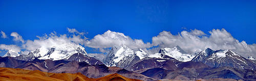
::南亚:周边国家The Indian subcontinent is a large landmass that juts into the Indian Ocean along the southern side of Asia, between Afghanistan and Myanmar and south of China. The Indian perimeter includes the southern countries of the Maldives and Sri Lanka, and the northern regions of the Punjab, Kashmir, Nepal, and Bhutan. This landmass has a long tectonic history and has been formed by the collision of the Indian Tectonic Plate with the Eurasian Plate. This tectonic collision has given rise to the highest mountain chains and ranges in the world along the northern and northwestern part of the Indian subcontinent known as the Himalayas.
::印度次大陆是沿着亚洲南部、阿富汗与缅甸之间和中国南部之间横跨印度洋的大片陆地,印度周边包括马尔代夫和斯里兰卡南部国家以及旁遮普、克什米尔、尼泊尔和不丹北部地区,这些陆地具有悠久的构造历史,是因印度构造板块与欧亚板块相撞而形成的,这种构造碰撞导致印度次大陆北面和西北部称为喜马拉雅山的世界上最高的山脉链和山脉。A view of the Himalayas from Tibet.
::西藏喜马拉雅山的景象
The Karakoram Mountains are located in northern Pakistan and Kashmir. Together with the other Himalayan Mountain ranges, they form an arc that stretches across the entire northern border of South Asia. Nepal and Bhutan are both located in the Himalayas. The Himalayan ranges have some of the highest peaks in the region, including Mount Everest (located on the border between Nepal and China) and K2 (located in Pakistan).
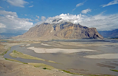
::卡拉科拉姆山脉位于巴基斯坦北部和克什米尔,与其他喜马拉雅山脉一道,形成横跨整个南亚北部边界的弧形山脉,尼泊尔和不丹都位于喜马拉雅山脉,喜马拉雅山脉是该区域一些最高山峰,包括珠穆朗玛峰(位于尼泊尔和中国边境)和K2(位于巴基斯坦)。In western Pakistan and western Afghanistan, the Hindu Kush mountain ranges that border this area are found. The Indus River flows from the northern part of the Karakoram mountains and creates a large, fertile flood plain. Along its northern area, the Indus River System has four main tributaries. Together, these rivers constitute the five rivers of the Punjab regions of Pakistan and India. Punjab means the “land of the five rivers” in the Punjabi language.
::在巴基斯坦西部和阿富汗西部,发现了与该地区接壤的兴都库什山脉,印度河从卡拉科拉姆山脉北部流出,形成一个肥沃的大洪泛平原,印度河系统在北部有四个主要支流,这些河流共同构成巴基斯坦和印度旁遮普地区的五条河流,旁遮普语为“五条河流的土地”。The Indus River near Skardu, in Gilgit.
::在吉尔吉特的斯卡尔杜附近的印地安河。Punjab
::旁遮普Punjab is a fertile agricultural region with a high population density located on the border between India and Pakistan. Areas of Punjab lie in both India and Pakistan. Where there are ample fresh water and bountiful food production, there is usually a high population density. Punjab is the most densely populated region in Pakistan. India has a separate state called Punjab. Its river valleys are excellent areas for agricultural production and contribute heavily to the provisions needed to feed the enormous populations of the two countries.
::旁遮普省是一个肥沃的农业地区,人口密度高,位于印度和巴基斯坦边境,旁遮普省位于印度和巴基斯坦,那里有充足的淡水和富足的粮食生产,通常人口密度高,旁遮普省是巴基斯坦人口最稠密的地区,印度有一个单独的邦,称为旁遮普省,其河谷是农业生产的极佳地区,对供养两国大量人口所需的供应作出了巨大贡献。Punjab is a geographical and cultural region in the northern part of the Indian subcontinent, comprising areas of eastern Pakistan and northern India.
::旁遮普是印度次大陆北部的一个地理和文化区域,由巴基斯坦东部和印度北部地区组成。
The Punjabi people are found in the Punjab State of India and the Punjab Province of Pakistan. This large cultural area was separated into two countries during Partition at the time of Indian independence and the creation of Pakistan in 1947. Most of the people in Punjab speak Punjabi, an Indo-European language. In a larger context, people with Punjabi background are considered one of the main ethnic groups in South Asia. Punjabis account for about 45 percent of the population of Pakistan.
::旁遮普人分布在印度旁遮普邦和巴基斯坦旁遮普省,在印度独立和1947年创建巴基斯坦期间,这一大片文化区被分割成两个国家,旁遮普人大多讲印度-欧洲语言旁遮普语,在更大范围内,旁遮普人被视为南亚的主要族裔群体之一,旁遮普人约占巴基斯坦人口的45%。This picture shows a wedding in Lahore, Pakistan, with men and women dressed in traditional outfits.
::这张照片展示了巴基斯坦拉合尔的婚礼,
In Pakistan, the Punjabis are grouped in clans and groups that correspond with traditional occupations. Traditionally, Punjabis are farmers and warriors, and in modern times are associated with agricultural professions and military life. Punjabis in Pakistan are predominantly Muslim, although a Christian minority exists. Indian Punjabis belong to traditional groups, including many of the same groups as in Pakistan, but many more. Most of the Muslim populations of Punjab migrated to Pakistan in 1947. As a result, most of the Indian Punjabis are Sikh with a Christian minority.
::在巴基斯坦,旁遮普人分为部族和与传统职业相对应的群体,传统上旁遮普人是农民和战士,在现代与农业职业和军事生活有关,旁遮普人主要为穆斯林,尽管存在基督教少数,但巴基斯坦旁遮普人主要为穆斯林,印度旁遮普人属于传统群体,包括许多与巴基斯坦相同的群体,但更多人,旁遮普人的大多数穆斯林人口于1947年移居巴基斯坦,结果,印度旁遮普人大多数是锡克人,属于基督教少数。President Obama greets Arjan Singh, Marshal of the Indian Air Force, at the At Home Reception on the Central Lawn of Mughal Garden in New Delhi. The highest-ranking general in the history of the Indian Air Force is a Punjabi Sikh.
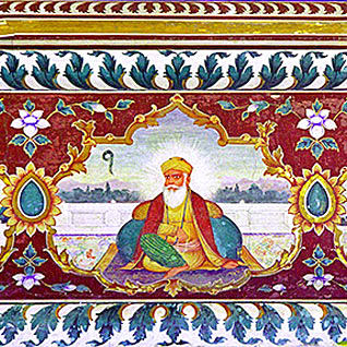
::奥巴马总统在印度空军元帅阿尔詹·辛格(Arjan Singh)新德里穆卧尔花园中央草坪家庭接待处迎接印度空军元帅阿尔詹·辛格(Arjan Singh ) 。 印度空军历史上最高级的将军是旁遮普族锡克教徒。The Punjab region of Pakistan and India is the homeland of the Sikhs, people who follow a religion that is different from Islam or Hinduism. Sikhism was founded by Guru Nanak Dev (1469-1538). All distinctions of caste, creed, race, or gender are rejected in this religion. In Sikhism, there is no priestly class. Every person is equally and fully responsible for leading a moral life, which eventually leads to universal salvation. Heaven and hell are not physical places, and God is the cosmic universal spirit. Historically, traditional Sikh men wear turbans on their heads and never cut their hair or beard. Sikhism is a universal religion. A prominent Sikh landmark and spiritual center is their Golden Temple, located in the city of Amritsar in the Indian state of Punjab.
::巴基斯坦和印度的旁遮普地区是锡克教徒的家园,他们信奉的是不同于伊斯兰教或印度教的宗教;锡克教是由奈纳克·德夫(1469-1538年)Guru Nanak Dev(1469-1538年)创立的;该宗教拒绝对种姓、信仰、种族或性别的一切区分;在锡克教中,没有宗教等级;每个人都对领导道德生活负有同等和完全的责任,最终导致普遍救赎;天堂和地狱不是物质场所,而上帝是宇宙的普世精神;历史上,传统的锡克族男子头上戴头巾,从不剪发,也不剃胡子;锡克教是一个普遍宗教;锡克教的标志性和精神中心是位于印度旁遮普邦安里察市的金殿。Sri Harmandir Sahib ("The abode of God"), also known as the Golden Temple, is located in the city of Amritsar, Punjab, India. It is one of the most revered spiritual sites of Sikhism.
::Sri Harmandir Sahib (“上帝的归宿 ” ) ( “上帝的归宿 ” ) , 也称金殿,位于印度旁遮普邦安里察市,是锡克教最受尊敬的精神遗迹之一。
Sikhism is a system of religious philosophy and expression, known as the Gurmat or the counsel of the gurus, or the Sikh Dharma (or way of life). Sikhism comes from the Hindi and Punjabi word sikhna , which means “to learn.” The principal belief in Sikhism is faith in the universal God. Sikhism promotes the pursuit of salvation through discipline and personal meditation on the name and message of God. However, it must be mentioned that Sikhs have a non-anthropomorphic concept of God; that is, Sikhs do not envision God as having any form or shape or mind similar to that of humans.
::锡克教是一个称为Gurmat的宗教哲学和表达体系,称为Gurmat或大师的顾问,或锡克Dharma(或生活方式),锡克教来自印地语和旁遮普语,这意味着“学习”。 锡克教的主要信仰是对普世上帝的信仰。 锡克教通过纪律和个人对上帝的名称和教义的冥想,促进拯救的追求。 然而,必须指出,锡克教有一个非人类形态的上帝概念,即锡克教不把上帝视为具有与人类相似的任何形态、形状或思想。Guru Nanak Dev Ji (April 15, 1469-September 22, 1539) was the founder of the religion of Sikhism and the first of the eleven Sikh Gurus.
::Guru Nanak Dev Ji(4月15日、1469年-9月22日、1539年)是锡克教的创始人,也是11个锡克古鲁斯教中的第一个。
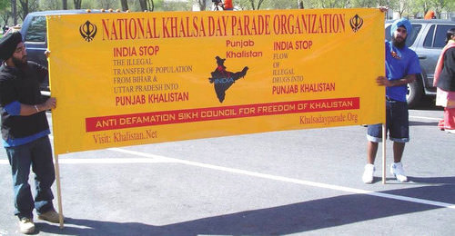
During the British colonial occupation of South Asia, Sikhs were elevated to positions of power to help the British rule over Muslim and Hindu populations. The Sikhs are often overshadowed by the large Hindu and Muslim populations in the realm. Many of the Sikhs would like to have their own nation-state, free from Muslim or Hindu domination, and would like to see the Punjab region become the new homeland for this nation-state, called Khalistan.
::在英国对南亚的殖民占领期间,锡克教被提升到权力地位,帮助英国统治穆斯林和印度教人口。 锡克教常常被王国内庞大的印度教和穆斯林人口蒙上阴影。 许多锡克教徒希望拥有自己的民族国家,不受穆斯林或印度教统治,并希望看到旁遮普地区成为这个民族国家的新家园,即卡利斯坦。They have held rallies and demonstrations to promote the creation of Khalistan. The Indian government has cracked down on militant movements that support the Khalistan concept. The Khalistan movement was more popular in the 1970s and 1980s and has been scaled down in recent decades. Proponents still attempt to attract young people and foreign donations to its cause. Khalistan does not have the support of the Pakistani and Indian governments. Khalistan is an example of the devolutionary push for a nation-state political unit for a particular group of people with similar aspirations or heritage.
::印度政府镇压了支持Khalistan概念的好战运动;Khalistan运动在1970年代和1980年代更受欢迎,近几十年来有所缩减;支持者仍然试图吸引年轻人和外国对其事业的捐款;Khalistan没有得到巴基斯坦和印度政府的支持;Khalistan是向具有类似愿望或遗产的特定群体移交民族国家政治单位的一个例子。Sikhs protest against India’s opposition to their proposed homeland (nation-state) in Punjab called Khalistan.
::锡克教徒抗议印度反对他们在旁遮普(Punjab)的家园(Nation- State),The Kingdom of Kashmir
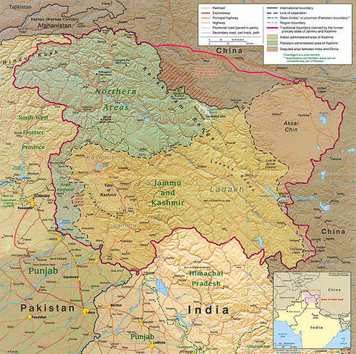
::克什米尔王国Located in the high mountains of the north is the former Kingdom of Kashmir, a separate kingdom before the British divided South Asia. In 1947, when the British drew the boundary between India and Pakistan, the leader of Kashmir, the maharajah, chose not to be a part of either country but to remain independent. About 75 percent of the population in Kashmir was Muslim. The rest, including the maharajah, were mainly Hindu. This arrangement worked for a time until the Muslim majority was encouraged by their fellow Muslims in Pakistan to join Pakistan.
::位于北部高山的原克什米尔王国是英国分裂的南亚之前的单独王国。 1947年,当英国人划定印度和巴基斯坦之间的边界时,克什米尔的领袖、大阿拉伯教徒选择了不是两国的一部分,而是保持独立。 克什米尔大约75%的人口是穆斯林,其余的人,包括大阿拉伯教徒,主要是印度教徒。 这一安排有一段时间有效,直到穆斯林多数在巴基斯坦的穆斯林同胞鼓励他们加入巴基斯坦。After a Muslim uprising, the maharajah asked the Indian military for assistance. India obliged because they saw it as an opportunity to oppose Pakistan one more time. Today Kashmir is divided, with Pakistan controlling the northern region, India controlling the southern region, and China controlling a portion of the eastern region. A cease-fire has been implemented, but outbreaks of fighting have occurred. The future of Kashmir is unclear. None of the countries involved wants to start a large-scale war, because they all have nuclear weapons.
::在一次穆斯林起义之后,印度大帝向印度军方请求援助。 印度被迫这样做,因为他们认为这是再次反对巴基斯坦的机会。 今天克什米尔分裂,巴基斯坦控制北部地区,印度控制南部地区,中国控制东部地区的一部分地区。 停火已经实施,但爆发了战斗。 克什米尔的未来还不清楚。 有关国家都不希望发动大规模战争,因为它们都有核武器。Kashmir is the northernmost geographical region of the Indian subcontinent.
::克什米尔是印度次大陆最北部的地理区域。
The conflict in Kashmir is about strategic location and control of water rather than labor and resources. It is unknown whether there are abundant minerals in the mountains in Kashmir to be mined, but regardless, there is little mining activity going on, not enough to cause conflict. One of the main physical geography features of importance is water. The Indus River flows through Kashmir from Tibet and into Pakistan. The control of this river system is critical to the survival of people living in northern Pakistan.
::克什米尔冲突涉及战略位置和对水的控制,而不是劳动力和资源的控制,尚不清楚克什米尔山区是否有大量矿物有待开采,但不管如何,采矿活动很少,不足以引起冲突。重要的地理特征之一是水。印度河从西藏流经克什米尔流入巴基斯坦。这一河流系统的控制对于巴基斯坦北部居民的生存至关重要。If India were to place a dam on the river and divert the water to their side of the border, to the dry regions of the south, Pakistan could suffer a water shortage in the northern part of the country. Another aspect of the Kashmir conflict goes back to the division of Pakistan and India, which pitted Muslims against Hindus along the border region. The religious differences have come to the surface again in the conflict over the control of Kashmir. Extremist movements within Kashmir by the Muslim population have fueled the division between those who support Pakistan and those who support Hindu-dominated India.
::如果印度在河上建大坝,将水分流到边界一侧,到南部干燥地区,巴基斯坦可能在该国北部缺水,克什米尔冲突的另一个方面可追溯到巴基斯坦和印度的分裂,巴基斯坦和印度沿边界地区将穆斯林与印度教徒混为一谈,在克什米尔控制冲突中,宗教分歧再次浮现出来,穆斯林人口在克什米尔内部的极端主义运动加剧了支持巴基斯坦的人与支持印度人占多数的印度的人之间的分裂。The Kingdom of Bhutan
::不丹王国 不丹王国
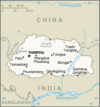
Map of Bhutan
::不丹地图
Landlocked and mountainous, the small Kingdom of is remotely located next to the high Himalayas between China and India. The mountain peaks reach more than 23,000 feet. Bhutan is about half the size in physical area of the US state of Kentucky and has fewer than one million people. The southern plains are warm, with subtropical weather, but the higher altitudes of the snow-capped mountains have polar-type climates.
::中国和印度之间的喜马拉雅山峰面积超过23 000英尺。 不丹的面积大约是美国肯塔基州实际面积的一半,人口不到100万。 南部平原是温暖的,有亚热带天气,但雪峰高海拔的山脉有极地型气候。The local people call their country the “Land of the Thunder Dragon” because of the harsh storms they experience. Bhutan has large areas of natural habitat that have not been disturbed by human activity. The natural environment and the unique heritage and culture of the people make Bhutan an attractive destination for world travelers.
::不丹的自然栖息地面积辽阔,没有受到人类活动的干扰,自然环境以及人民独特的遗产和文化使不丹成为吸引世界旅游者的目的地。Bhutan is a small country without much industry or high-tech corporate involvement. Forestry and agriculture are the main economic activities, which account for approximately 60 percent of the country’s population. Grazing livestock and subsistence agriculture are the primary types of farming. Increasing the country’s modest infrastructure is hampered by its high mountains and remote location. India is Bhutan’s main trading partner and has played an important role in the country’s development and economic situation.
::不丹是一个小国,没有太多的工业或高科技公司参与。 林业和农业是主要经济活动,约占不丹人口的60%。 放牧牲畜和自给农业是主要农业类型。 增加不丹有限的基础设施受到高山和偏远地点的阻碍。 印度是不丹的主要贸易伙伴,在不丹的发展和经济形势中发挥了重要作用。Paro Dzong is the center of civil and religious authority in the Paro valley in western Bhutan.
::Paro Dzong是不丹西部Paro河谷的民政和宗教权威中心。
Modern transportation and communication technologies are being introduced in Bhutan and are changing how the country is connected to the global economy. Satellite and cable television, mobile phone networks, the Internet, and major airline service are opening the doors of opportunity and interaction between the people of Bhutan and the rest of the world. Introduction of technological services has prompted Bhutan’s government to take steps to protect its environment and unique heritage.
::不丹正在引进现代交通和通信技术,并正在改变不丹与全球经济的联系方式。 卫星和有线电视、移动电话网络、互联网和主要航空服务正在打开不丹人民与世界其他地方人民之间机会和互动的大门。 技术服务的引入促使不丹政府采取措施保护环境和独特遗产。Tourism has become a major focus of the changes. The country has stepped up its efforts to develop tourism but has targeted a specific type of traveler. Bhutan is an expensive place to visit, which has been the biggest deterrent for travelers. Visitors from places other than India and Bangladesh must agree to strict requirements set by the suppliers of Bhutanese tourism, including large daily fees just to be in the country. Tourism is increasing in Bhutan but remains highly selective in its requirements and regulations. These measures are to ensure that the environmental health of the country remains intact and that there is minimal cultural impact from outsiders.
::不丹是一个昂贵的旅游地点,对旅游者来说是最大的威慑因素。来自印度和孟加拉国以外的其他地方的游客必须同意不丹旅游供应商规定的严格要求,包括仅在该国的日费; 不丹的旅游业正在增加,但其要求和条例仍然有很高的选择性。这些措施是为了确保该国的环境卫生保持不变,并确保外来者对文化的影响最小。Buddhism is the state religion and is followed by about 75 percent of the population. Hinduism is the second-largest religion and is followed by the other 25 percent of the population. One of the principles of the government in regulating development projects has been the concept of , which is used as a guide to determine the impact of a project on the culture and people of Bhutan.
::印度教是第二大宗教,其次是其他25%的人口。 政府在管理发展项目时的原则之一是概念,这一概念被用作确定一个项目对不丹文化和人民的影响的指南。The stern measures regarding development have protected the country from serious environmental degradation and have helped to sustain the lifestyles of the Bhutanese people. Some measures may appear harsh to outsiders, but the country is implementing these measures to promote the health and well-being of its people. For example, tobacco products are banned from being sold in the country. Democratic elections are becoming standard after centuries of rule by a monarchy. The intent of the transition is to provide the people with more direct control of their government and country.
::严厉的发展措施保护了不丹免受严重的环境退化,有助于保持不丹人民的生活方式,有些措施对外部人来说可能显得很严厉,但该国正在执行这些措施,以促进其人民的健康和福祉,例如,禁止在该国出售烟草制品,君主统治几个世纪后民主选举正在成为标准,过渡的目的是让人民更直接地控制其政府和国家。Interesting points about the culture of Bhutan include the issue of marriage. Marriages based on love are becoming more common in the cities, while arranged marriages remain a tradition in many of the smaller villages. Under the current legal system, women have the right to inheritance. Homes and personal possessions are passed down through a family’s female children. Traditionally, male children do not inherit. Men are expected to earn their own livelihood and if they get married will most often live in the wife’s house.
::关于不丹文化的有趣观点包括婚姻问题。基于爱的婚姻在城市中越来越普遍,而包办婚姻在许多较小的村庄中仍是一种传统。在现行法律制度下,妇女有继承权,家庭和私人财产由家庭女童继承。传统上,男性子女不继承遗产。男性应自己谋生,如果结婚,则大多住在妻子家里。The Kingdom of Nepal
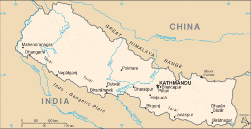
::尼泊尔王国
Map of Nepal
::尼泊尔地图
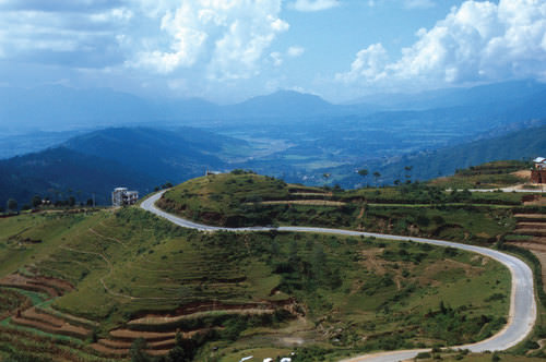
Bordering the highest mountain range in the world, the Himalayas, the country of is isolated from any seacoast and buffered from the outside world by India and China. Nepal is about the same size in physical area as Bangladesh and is home to almost 30 million people. More than 80 percent of its people work the land in a region that is suffering from severe deforestation and soil erosion. Trees are cut down to build houses, to cook food, and to keep warm. Without trees to hold the soil, the monsoon rains wash soil from the mountain fields into the valleys.
::与世界最高山脉、喜马拉雅山相邻的尼泊尔与印度和中国的任何海岸隔绝,与外部世界隔绝。尼泊尔的自然面积与孟加拉国大致相同,有近3 000万人居住。尼泊尔80%以上的人口在一个严重砍伐森林和土壤侵蚀的地区耕种土地。树木被砍下来用于建造房屋、烹饪食物和保持温暖。没有树木来控制土壤,季风雨将土壤从山区冲进山谷。Deforestation is a serious problem. The trees are cut down for firewood and building materials. The winding road connects Kathmandu with Tibet.
::砍伐森林是一个严重的问题,树木被砍掉,用作木柴和建筑材料。
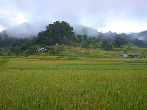
The combination of the fast-growing population with the loss of food-growing capacity means it is only a matter of time before a major crisis occurs in Nepal. Nepal’s best farmland is in the Terai lowlands of southern Nepal, while the north is mountainous. The towering elevation of the Himalayas restricts human habitation in the north. High population growth has also been outstripping the country’s economic growth rate in recent years.
::快速增长的人口与粮食增产能力丧失的结合意味着尼泊尔发生重大危机只是时间问题。 尼泊尔最好的农田位于尼泊尔南部的德赖低地,而北部则是山地。 喜马拉雅山高涨限制了北部的人类居住。 近年来,高人口增长率也超过了尼泊尔的经济增长率。Mist rising from the rice fields in the Terai Lowlands of Nepal.
::来自尼泊尔德赖低地稻田的迷雾上升。
Nepal has an abundance of tourist attractions, Mount Everest being its best known. In addition, there are hundreds of ancient temples and monasteries. Swift flowing streams and high-mountain terrain support a modest trekking industry. Visitors to Nepal have an opportunity to glimpse a rich culture that few outsiders have witnessed. The downside is that tourism demands an investment in infrastructure and services.
::尼泊尔有许多旅游景点,珠穆朗玛峰是其最著名的景点。此外,还有数百座古老的寺庙和修道院。 快速流动的溪流和高山地形支撑着一个温和的出行业。 访问尼泊尔的尼泊尔人有机会看到少数外来人所目睹的丰富文化。 其不利之处在于旅游业要求投资于基础设施和服务。Such investments direct funds away from schools, medical clinics, and public services needed by the Nepalese people. Income from tourism is needed and always welcome, but the trade-off with investments is a difficult choice to make. Tourism in Nepal is not as restrictive as that of Bhutan, and the unique physical and cultural landscapes will continue to draw travelers from throughout the world.
::这些投资直接来自尼泊尔人民需要的学校、诊所和公共服务。 旅游收入是需要的,而且总是受欢迎的,但与投资的权衡是很难选择的。 尼泊尔的旅游业没有不丹的旅游业那么严格,独特的自然和文化景观将继续吸引来自世界各地的旅游者。Hinduism is the main religion in Nepal, but a blend of Buddhism is more prevalent in the north. The guardian deity of Nepal is Shiva. Pashupatinath Temple , the world’s most significant Shiva worship site, is located in the capital city of Kathmandu. This Shiva temple is not only a UNESCO World Heritage Site but a major destination for Hindu pilgrims from around the world. Buddhist and Hindu beliefs often mix in Nepal. There are certain situations where the same deities and temples can be honored or worshipped by members of both religions.
::印度教是尼泊尔的主要宗教,但佛教混合在北方更为普遍。尼泊尔的守护神神是Shiva。 普什帕蒂那蒂那寺(Pashupatinath)是世界上最重要的什叶派礼拜场所,位于首都加德满都。 这个神庙不仅是教科文组织的世界遗产,而且是全世界印度教徒的主要目的地。 佛教和印度教信仰常常在尼泊尔混杂在一起。 某些情况下,同样的神庙和神庙可以被两个宗教的成员尊崇或崇拜。The Pashupatinath Temple is a famous and sacred Hindu temple complex.
::Pashupatinath寺是一座著名的、神圣的印度教寺庙。
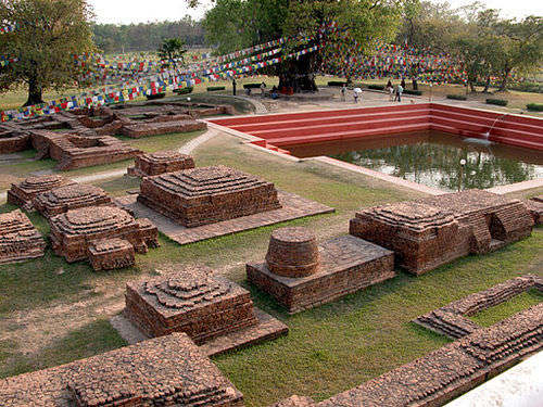
In a different part of Nepal, Lumbini—near the city of Bhairahawa, on the border with India—is another UNESCO World Heritage Site. This site is the birthplace of the Siddhartha Gautama, the founder of Buddhism. Prince Siddhartha Gautama was born about 563 BCE, near Lumbini. The city has recognized the prince with a number of monasteries and temples built in his honor.
::在尼泊尔另一部分,与印度接壤的Bhairahawa市附近的Lumbini是教科文组织的另一个世界遗产遗址,是佛教创始人Siddhartha Gautama的出生地,Siddhartha Gautama亲王在Lumbini附近出生了563 BCE约563 BCE。An entire development zone is restricted to nothing but monasteries and temples. No other commercial or public buildings—such as hotels, shops, or businesses—can be constructed in the zone. The different branches of the Buddhist faith each have their own specific designated sections of the zone. Lumbini is a major pilgrimage site for Buddhist believers from around the world.
::整个发展区除寺院和寺庙外,一无所有,其他商业或公共建筑,例如旅馆、商店或企业,都不能在该区建造,佛教的不同分支都有自己指定的区段,蓝毗尼是全世界佛教信徒的主要朝圣场所。Lumbinī, which means "the lovely," is a Buddhist pilgrimage site in the Rupandehi District of Province No. 5 in Nepal.
::表示「可爱」(Lumbini)是尼泊尔第五省鲁潘德希区佛教朝圣地。
In the late 1700s, local states of Nepal were consolidated into the one kingdom and ruled by a monarchy. The kingdom was ruled by royal families until the mid-1900s. Nepal has been free of British influence since 1947 but has had trouble establishing a stable central government. The royal family in charge of the kingdom was replaced in 1951, and further democratic reforms were made in 1990. Communist partisans from China have been active in insurgent activities.
::1700年代末,尼泊尔的地方邦合并为单一王国,由君主统治,王国由王室家族统治,直到1900年代中期为止,尼泊尔自1947年以来一直没有英国的影响力,但很难建立稳定的中央政府。 1951年,负责王国的王室被取代,1990年进行了进一步的民主改革,来自中国的共产党党派积极参与了叛乱活动。Frequent protests and civil unrest have caused political instability, which has discouraged tourism and has depressed the economy even further. The Maoist Communist movement and other opposition political parties held mass protests, culminating in a peace accord. Ensuing elections created the establishment of a federal democratic republic. The first president of Nepal was sworn into office in 2008. There is still much tension in the country between those loyal to the royal family and those wanting the royal family to be dissolved. Without a stable government, economic and political progress in Nepal will be a serious challenge.
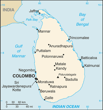
::频繁的抗议和内乱造成了政治不稳定,这阻碍了旅游业,进一步压低了经济。 毛主义共产党运动和其他反对派政党举行了大规模抗议,最终达成了和平协议。 即将开始的选举创造了一个联邦民主共和国的建立。 尼泊尔首任总统于2008年就职。 忠于王室的人和希望皇室解体的人之间在国内仍然有很大的紧张关系。 没有稳定的政府,尼泊尔的经济和政治进步将是一个严峻的挑战。Sri Lanka
::斯里兰卡 斯里兰卡 斯里兰卡
Map of Sri Lanka
::斯里兰卡地图
is a beautiful island about half of the size of Nepal. The island has a warm, tropical type A climate, with forested hills and mountains in the center. Rivers flow from the center outward to water the farm fields of rice and other crops. The best farmland is located in the Sinhalese-controlled areas of the southwestern portions of the island. Cinnamon is native to the island and has been cultivated since colonial times as an important export. Coconuts, coffee, and tea are also important export products.
::尼泊尔是一个美丽的岛屿,面积约为尼泊尔面积的一半。岛屿有温暖的热带A型气候,其中以森林为主的山丘和山丘为中心。河流从中间向外流动,为稻米和其他作物的农田供水。最好的农田位于该岛西南部的僧伽罗人控制区。西南岛土生土长,自殖民时期以来就作为重要出口产品耕种。椰菜、咖啡和茶也是重要的出口产品。The island is home to various national parks, four biosphere reserves, and several wild elephant herds. Sri Lanka has the potential to become a major tourist destination with high incomes and a hub for international trade. Factors working against Sri Lanka reaching its potential are not based on its physical geography or location, but rather they are linked back to colonialism and cultural or ethnic divisions between the Sinhalese majority and the Tamil minority.
::斯里兰卡有可能成为收入高的主要旅游目的地和国际贸易枢纽,对斯里兰卡具有潜力的因素并非基于其地理或地理位置,而是与殖民主义以及僧伽罗人多数和泰米尔少数民族之间的文化或族裔分歧有关。The people of South Asia follow various religions. Sri Lanka has its own unique circumstances and is a mixed country with a strong Buddhist majority and an active Hindu minority. The conflict between the majority and the minority ethnic groups fueled a low-level civil war on the island for decades. Differences in religion, ethnicity, and politics have brought the country to halt on various occasions.
::南亚人民信奉各种宗教,斯里兰卡有其自身的独特情况,是一个佛教占多数且活跃的印度少数派混杂的国家,多数派和少数民族之间的冲突助长了该岛几十年来的低水平内战。 宗教、族裔和政治差异使该国在各种场合都停止了。A Buddhist statue in the ancient capital city of Polonnaruwa.
::古城波隆纳鲁瓦的佛像Sinhalese people from somewhere in northern India moved to the island of Sri Lanka about 2,500 years ago. The Sinhalese brought with them Buddhism and the Sinhala language, which belongs to the Indo-European language family. They established themselves on the island for centuries. Sri Lanka was first colonized by Portugal, then Holland. When the British colonized South Asia, they took control of Sri Lanka. It was called Ceylon at that time and changed its name to Sri Lanka in 1972.
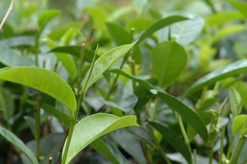
::2500年前,僧伽罗人从印度北部的某个地方搬到了斯里兰卡岛,僧伽罗人带来了佛教和僧伽罗语,他们属于印裔欧洲语家庭,在岛上定居了几个世纪。斯里兰卡最初被葡萄牙、然后是荷兰殖民。当英国殖民南亚时,他们控制了斯里兰卡。当时,它被称为锡兰,1972年改名为斯里兰卡。The higher elevations of the center of the island were excellent for tea production. British colonizers established tea plantations there. To work the plantations, Britain brought thousands of additional Tamil laborers from southern India across the Polk Strait to Ceylon. Most of the Tamil speak a Dravidian language and follow the Hindu religion.
::英国殖民者在那里建立了茶叶种植园。 为了在种植园工作,英国从印度南部将成千上万的泰米尔劳工从波尔克海峡带到锡兰。 大多数泰米尔人会说德拉维迪亚语并遵循印度教。The International Organization for Standardization (ISO) considers Ceylon tea, which is grown in Sri Lanka, the cleanest tea in the world.
::国际标准化组织(标准化组织)认为,斯里兰卡种植的锡兰茶是世界上最干净的茶。
When the British were forced out of South Asia and left Ceylon, the Tamils remained on the island. The Tamils now make up only 10 percent of the population and live mainly in the northeastern region of the island. They have been pressuring the Sinhalese majority to split the island politically and grant them independence. An insurgent civil war was waged for decades between the Tamil guerillas—called the Tamil Tigers—and the Sinhalese government. About 60,000 to 80,000 people died in this conflict.
::当英国人被迫离开南亚并离开锡兰时,泰米尔人仍然留在岛上。泰米尔人现在只占人口的10%,主要居住在该岛东北部地区。他们一直在向僧伽罗人施加压力,迫使僧伽罗人多数从政治上分裂岛屿并给予他们独立。 数十年来,泰米尔游击队(又称泰米尔猛虎组织)与僧伽罗政府之间爆发了一场叛乱内战。 大约60 000至80 000人在这次冲突中丧生。Originally only controlling the Jaffna Peninsula, the Tamil Tigers later made claims on a large portion of the northeastern part of the island. The Tamil Tigers created a government in the north called Eelam and wanted to legitimize it. The Sri Lankan president announced an end to the civil war in 2009, and the Tigers admitted defeat at that time. This civil war devastated Sri Lanka’s tourism industry and discouraged foreign investments, further reducing economic opportunities for the island.
::泰米尔猛虎组织最初只是控制贾夫纳半岛,但后来却对塞岛东北部的大部分地区提出主张。 泰米尔猛虎组织在北部建立了一个叫伊拉姆的政府,希望使其合法化。 斯里兰卡总统宣布2009年结束内战,当时虎组织承认失败。 这场内战摧毁了斯里兰卡的旅游业,抑制了外国投资,进一步减少了塞岛的经济机会。The Maldives
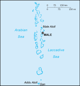
::马尔代夫
Map of the Maldives
::马尔代夫地图
Just north of the Equator in the Indian Ocean to the southwest of India lie the , a group of low-lying islands that consists of 26 encompassing a territory of only about 115 square miles. Within the atolls are approximately 1,200 small islands, of which about 200 are inhabited. Portugal controlled the Maldives from 1558 during their colonial expansion into Asia. Holland took over from the Portuguese in 1654.
::位于印度西南印度洋赤道以北的印度洋赤道以北, 由26个地势低洼岛屿组成, 领土面积约115平方英里,环礁岛内约有1 200个小岛,其中约有200个有人居住, 葡萄牙从1558年殖民扩张到亚洲期间控制马尔代夫, 荷兰于1654年从葡萄牙接管。The Maldives became a British protectorate in 1887, which lasted until 1965 when independence was achieved. Three years later the country became a republic. The Maldives is a country with many extremes. It is Asia’s smallest nation in both physical area and population. The island nation has the smallest physical area of any country with a majority Muslim population. The average elevation—four feet and 11 inches above sea level—is the lowest in the world for any country.
::马尔代夫于1887年成为英国保护地,一直持续到1965年独立时,三年后成为共和国,马尔代夫是一个多极端的国家,是亚洲最小的自然区和人口国家,岛屿国家是穆斯林人口占多数的任何国家中最小的自然区,海拔平均为四英尺零十一英寸,是世界上任何国家最低的。Fishing and tourism are the chief methods for Maldivians to earn a living. Tourism has increased in recent years. The many islands and atolls are attractive destinations for world travelers. The first tourist resort opened in 1972. Since that time, dozens of world-class resort facilities have opened for business across the . Tourism is the country’s number one means of gaining wealth. The coral reefs that make up the island chain are excellent for diving and water sports. The tropical climate and miles of sandy beaches provide for an attractive tourism agenda.
::渔业和旅游业是马尔代夫人谋生的主要方法。近年来,旅游业有所增长。许多岛屿和环礁岛是吸引世界游客的目的地。1972年首次开放旅游胜地。自此以来,已有数十个世界级度假胜地开放,供整个国家经营。旅游业是马尔代夫获得财富的首要手段。构成岛屿链的珊瑚礁对于潜水和水运动来说是极好的。热带气候和沙滩的里程提供了具有吸引力的旅游议程。The Maldives has become one of the world's best scuba diving destinations.
::马尔代夫已成为世界上最好的潜水潜水目的地之一。
The Maldives is an example of an entire country that could be in danger of flooding because of climate change if polar ice melts and sea levels rise. Concerns over the future of the islands gave a reason for the president of the country to announce a plan in 2008 to purchase land in other countries in case sea levels rise to a point where the Maldives are no longer habitable.
::马尔代夫就是一个例子,因为如果极地冰融化和海平面升高,整个国家都可能因气候变化而面临洪水的危险。 马尔代夫对群岛未来的担忧使该国总统有理由在2008年宣布一项计划,在海平面升高到马尔代夫不再适宜居住时购买其他国家的土地。The purchase of land from tourism receipts would provide a place for the Maldivians to move in case they had to evacuate the islands. The administration of the Maldives has worked hard to lobby the international community to address the increase in greenhouse gas emissions and the possibility of an increase in sea level caused by the global warming aspect of climate change.
::从旅游收入中购买土地将为马尔代夫人提供一个行动场所,以备他们不得不撤离这些岛屿,马尔代夫行政当局一直努力游说国际社会,解决气候变化的全球升温导致的温室气体排放增加和海平面上升的可能性。
Key Takeaways
::密钥外出-
Punjab is a highly productive agricultural region located partly in Pakistan and partly in India. The region is home to the Sikh population, which has proposed having its own nation-state.
::旁遮普是一个生产力很高的农业地区,部分位于巴基斯坦,部分位于印度,该地区是锡克族人口的家园,锡克族提议建立自己的民族国家。 -
Kashmir is divided between Pakistan, China, and India. The religious differences and the control of a valuable water source are at the core of this conflict.
::克什米尔分巴基斯坦、中国和印度,宗教差异和对宝贵水源的控制是这场冲突的核心。 -
Nepal borders the Himalayan Mountains and has an economy based on agriculture and tourism. High population growth has been stripping the land of trees, causing serious deforestation issues and soil erosion.
::尼泊尔与喜马拉雅山接壤,其经济以农业和旅游业为基础,人口高速增长使土地丧失树木,造成严重的毁林问题和土壤侵蚀。 -
The Kingdom of Bhutan has placed major restrictions on tourism to protect its environment and limit outside influences on its culture.
::不丹王国对旅游业实行重大限制,以保护其环境,并限制外界对其文化的影响。 -
The beautiful tropical island of Sri Lanka experienced a low-level civil war for decades between the Sinhalese Buddhist majority and the Tamil Hindu minority. The island has an excellent location and potential for economic development.
::斯里兰卡美丽的热带岛屿在僧伽罗佛教多数与泰米尔印度教少数之间经历了几十年的低水平内战,该岛屿的位置和经济发展潜力都很好。 -
The archipelago of the Maldives is a small country that depends on tourism for its economic survival. The low elevation of its land area makes it subject to flooding due to the effects of climate change.
::马尔代夫群岛是一个小国,依靠旅游业维持经济生存,其陆地面积低海拔,由于气候变化的影响,造成洪水泛滥。
Vocabulary Terms
::词汇术语术语Chapter 9.2 The Peripheral States
::第9.2章 周边国家outsourcing – the practice of hiring labor from sources outside of the company or outside of the nation in which the company is located
::外包 -- -- 从公司所在国以外或公司所在国以外的来源雇用劳工的做法monsoon – seasonal winds that bring moist air in the summer and dry air in the winter across much of southern and eastern Asia
::季风 — — 在南亚和东亚大部分地区,季节性风在夏季带来潮湿空气,在冬季带来干燥空气。subcontinent – large land mass that is part of a larger continental landmass
::亚次大陆-大陆地面积,是大大陆陆地的一部分polytheism – belief in multiple gods
::信仰多神的多神主义Applying Knowledge
::应用知识Discussion and Study Questions
::讨论和研究问题-
Why is the Punjab region vital to both Pakistan and India?
::为什么旁遮普地区对巴基斯坦和印度都至关重要? -
What has been one political goal of the Sikhs living in Punjab?
::生活在旁遮普的锡克教徒的政治目标是什么? -
What three countries control parts of the Kingdom of Kashmir?
::哪些三个国家控制了克什米尔王国的部分地区? -
Why is the region of Kashmir vital to South Asia’s viability?
::为什么克什米尔地区对南亚的生存能力至关重要? -
Why is Bhutan so selective about admitting tourists?
::为什么不丹如此有选择性地接纳游客? -
Explain Bhutan’s guiding philosophy regarding development.
::解释不丹关于发展的指导哲学。 -
Why is Nepal experiencing environmental degradation?
::为什么尼泊尔面临环境退化? -
What was the civil war about in Sri Lanka? What did each side want?
::斯里兰卡的内战是怎么回事? -
What is it about each country listed that is attractive to the tourism industry?
::对旅游业有吸引力的每一个名单所列国家的情况如何? -
What plan was announced to address the Maldives’s environmental concerns?
::宣布了何种计划来解决马尔代夫的环境问题?
Real-World Geography Exercise
::现实世界地理演习Using , locate each one of the places below. Next, choose one of the places and create a SWAY or a PowerPoint presentation. Include important facts, maps, images, and videos.
::使用, 定位下面每个位置。 接下来, 选择一个位置, 创建一个 SWAY 或 PowerPoint 演示。 包括重要的事实、 地图、 图像和视频 。-
Jaffna Peninsula
::贾夫纳半岛 -
Lumbini
::伦比尼 -
Mt. Everest
::珠穆峰 -
Polk Strait
::Polk海峡 -
Tarai lowlands
::德赖低地
Videos for Geography Enrichment
::地理丰富视频Helpful Websites for the Study of Geography
::地理研究有用网站is an encyclopedia funded by the Canadian government covering all branches of knowledge. Their scholarly collection includes interactive materials.
::该百科全书由加拿大政府资助,涵盖所有知识分支,其学术收藏包括交互式材料。provides information on the people, history, government, economy, energy, geography, communications, transportation, military, and transnational issues for the world's entities.
::向世界各实体提供关于人民、历史、政府、经济、能源、地理、通信、运输、军事和跨国问题的资料。is a US government website where you can find federal legislation, past and present, as well as information about the US legal system.
::是一个美国政府的网站,您可以在此找到过去和现在的联邦立法以及关于美国法律制度的信息。is a government agency website that provides current news, resources, topics of interest, information about drugs, careers in the DEA, and a tip hotline.
::是一个政府机构网站,提供最新消息、资源、感兴趣的话题、毒品信息、在缉毒局的职业以及一条小费热线。is the largest library in the world and provides manuscripts, files, information, pictures, and videos.
::图书馆是世界上最大的图书馆,提供手稿、文件、信息、图片和录像。is a US government agency website that allows users to search for and retrieve satellite images of Earth.
::这是一个美国政府机构的网站,用户可以搜索和检索地球的卫星图像。is a US government website that provides historical documents, photos, records, publications, and educator resources.
::这是一个美国政府网站,提供历史文件、照片、记录、出版物和教育资源。is a US government agency website that provides weather-related information and ocean research.
::是一个提供气象信息和海洋研究的美国政府机构网站。is a website by the United States Geological Survey and other federal, state, and local agencies that delivers topographic information for the United States.
::这是美国地质调查局和其他联邦、州和地方机构为美国提供地形信息的网站。is a massive central data source and a handy way to graphically compare nations.
::是一个庞大的中央数据源,是用图形比较国家的一种方便方式。is a website that measures most locations in the world for air pollution in real time.
::是一个实时测量世界上大多数空气污染地点的网站。is a unique statistical database, which allows you to research and compare a multitude of different data on US states.
::这是一个独特的统计数据库, 使你能够研究和比较关于美国各州的多种不同数据。is an international organization founded in 1945 and made up of 193 member states. The UN maintains international peace and security, protects human rights, delivers humanitarian aid, promotes sustainable development, and upholds international law.
::联合国是一个国际组织,成立于1945年,由193个成员国组成。 联合国维护国际和平与安全,保护人权,提供人道主义援助,促进可持续发展,维护国际法。is a US government agency that provides a population clock, data, surveys, statistics, a library with information and infographics, news about the economy, and much more.
::这是一个美国政府机构,它提供人口钟、数据、调查、统计、一个拥有信息和信息资料的图书馆、关于经济的新闻,以及更多。is a US government agency website that provides scientific information about the natural hazards that threaten lives, the natural resources we rely on, the health of our ecosystems and environment, and the impacts of climate and land-use change.
::这是一个美国政府机构的网站,提供科学信息,说明威胁生命的自然危害、我们赖以生存的自然资源、生态系统和环境的健康以及气候和土地使用变化的影响。is a US government website that provides the latest presidential news, information about the budget, policy, defense, and many more topics.
::提供最新总统新闻、预算、政策、国防等资讯, 以及更多议题。is under the United Nations and provides leadership on matters critical to health, shapes the research agenda on health, and monitors the health situation and assessing health trends around the world. Their website provides information on the state of health around the world, outbreaks, current health news, and more.
::网站提供世界各地卫生状况、疫情爆发、最新卫生新闻等信息。is an intergovernmental organization that regulates international trade. The website provides information on the history of the multilateral trading system, featured videos, news and events, trade topics, and more.
::该网站提供关于多边贸易体系历史的信息、视频、新闻和事件、贸易专题等等。 -
Outline the main physical features of the countries described in this section.


. The holiest shrine in Sikhism located in the city of Amritsar, India.")