10.1 东亚:介绍王国(1天)
章节大纲
-
Chapter Challenges
::章次 挑战-
Outline the countries and territories that are included in East Asia.
::概述东亚所包括的国家和领土。 -
Describe the main physical features and climate types of each country.
::描述每个国家的主要物理特征和气候类型。 -
Understand the relationship between physical geography and human populations in East Asia.
::了解东亚地理物理地理与人口之间的关系。 -
Summarize the main objectives in building the Three Gorges Dam.
::概述建造三峡大坝的主要目标。 -
Describe how colonialism impacted China.
::说明殖民主义对中国的影响。 -
Outline the various countries and regions that were controlled by colonial interests.
::概述受殖民利益控制的各种国家和区域。 -
Outline the three-way split in China after its revolution and where each of the three groups ended up living.
::描述中国革命后三极分化的情况,
Student Learning Objectives
::学生学习目标TEKS Regional Unit 10 East and Southeast Asia: Chapter 10.1 Introducing the Realm
::TEKS 东亚和东南亚10区域股:第10.1章 介绍王国WG.1A Analyze the effects of physical and human geographic patterns and processes on the past and describe their impact on the present, including significant physical features and environmental conditions that influenced migration patterns and shaped the distribution of culture groups today.
::WG.1A 分析物理和人类地理模式和过程对过去的影响,并描述其对目前的影响,包括影响移徙模式并影响当今文化群体分布的重要物理特征和环境条件。WG.5A Analyze how the character of a place is related to its political, economic, social, and cultural elements.
::WG.5A 分析一个地方的特性如何与其政治、经济、社会和文化因素相关。WG.6A Locate and describe human and physical features that influence the size and distribution of settlements.
::WG.6A 确定并描述影响定居点规模和分布的人文和物理特征。WG.6B Explain the processes that have caused changes in settlement patterns, including urbanization, transportation, access to and availability of resources, and economic activities.
::WG.6B 解释导致住区模式变化的进程,包括城市化、运输、获得和获得资源以及经济活动。WG.8A Compare ways that humans depend on, adapt to, and modify the physical environment, including the influences of culture and technology.
::WG.8A 比较人类依赖、适应和改变自然环境的方式,包括文化和技术的影响。WG.9A Identify physical and/or human factors such as climate, vegetation, language, trade networks, political units, river systems, and religion that constitute a region.
::WG.9A 查明构成区域的自然和/或人类因素,如气候、植被、语言、贸易网络、政治单位、河流系统和宗教。WG.10A Describe the forces that determine the distribution of goods and services in free enterprise, socialist, and communist economic systems.
::WG.10A 描述决定自由企业、社会主义和共产主义经济体系中货物和服务分配的势力。WG.13A Interpret maps to explain the division of land, including man-made and natural borders, into separate political units such as cities, states, or countries.
::WG.13A 解释地图,解释土地划分,包括人造边界和自然边界,分为不同的政治单位,如城市、州或国家。WG.14C Analyze the human and physical factors that influence the power to control territory and resources, create conflict/war, and impact international political relations of sovereign nations such as China.
::WG.14C 分析影响控制领土和资源的权力、制造冲突/战争以及影响中国等主权国家国际政治关系的人力和物质因素。WG.22C Use geographic terminology correctly.
::WG.22C 正确使用地理术语。WG.22D Use standard grammar, spelling, sentence structure, and punctuation.
::WG.22D 使用标准语法、拼写、句子结构和标点。East Asia: Introducing the Realm
::东亚:介绍王国Physical Geography
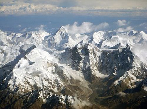
::物理地理East Asia is surrounded by a series of mountain ranges in the west, Mongolia, and Russia in the north, and Southeast Asia to the south. The Himalayas border Tibet and Nepal; the Karakoram Ranges, Pamirs, and the Tian Shan Mountains shadow Central Asia; and the Altay Mountains are next to Russia. The Himalayan Mountains are among the highest mountain ranges in the world, and Mount Everest is the planet’s tallest peak.
::东亚周围环绕着一系列山脉:西部、蒙古和俄罗斯,北部和东南亚。 喜马拉雅山脉与西藏和尼泊尔接壤;卡拉科拉姆山脉、帕米尔山脉和天山山影子中亚;阿尔泰山脉与俄罗斯相邻。 喜马拉雅山脉是世界上最高的山脉之一,珠穆朗玛峰是地球上最高的山峰。
The Tian Shan, meaning the "Mountains of Heaven," is a large system of mountain ranges located in Central Asia.
::天山,意思是“天山”, 是位于中亚的大型山脉系统。
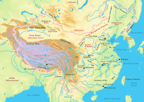
These high ranges create a rain shadow effect, generating the dry arid conditions of type B climates that dominate western China. The desert conditions of western China give rise to a large uninhabitable region in its center. Melting snow from the high elevations feeds many of the streams that transition into the major rivers that flow toward the east.
::这些高海拔的海拔造成了雨影效应,形成了以中国西部为主的B型气候的干燥干旱条件。 中国西部的沙漠条件导致其中部形成一个大面积无法居住的区域。 高海拔的融雪为许多向向东流动的主要河流过渡的溪流提供了食物。Created by tectonic plate action, the many mountain ranges are also home to earthquakes and tremors that are devastating to life. The Indian tectonic plate is still pushing northward into the Eurasian plate, forcing the Himalayan ranges upward. With an average elevation of 15,000 feet, the Tibetan Plateau is the largest plateau region of the world. It has high elevations and type H climates.
::许多山脉都是由构造板块动作形成的,许多山脉也是地震和震颤的家园,地震和震颤对生命造成破坏。 印度的构造板块仍在向北推向欧亚板块,迫使喜马拉雅山脉向上攀升。 西藏高原的平均海拔为15,000英尺,是世界上最大的高原地区。 它有高海拔和H型气候。The plateau is sparsely populated and the only places with human habitation are the river valleys. Lhasa is the largest city of the sparsely populated region. Sometimes called “the Roof of the World,” the Tibetan Plateau is over three miles above sea level and is surrounded by majestic mountain ranges, including Mount Everest and K2. The small amount of precipitation that occurs often comes in the form of hailstorms mixed with wind. Its landscape is generally rocky and barren.
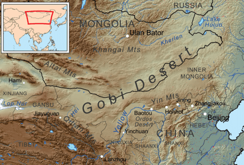
::高原人口稀少,唯一有人类居住的地方是河谷,拉萨是人口稀少地区最大的城市。 有时被称为“世界之城 ” ( The Roof of the World) , 西藏高原比海平面高出三英里,周围是巨大的山脉,包括珠穆朗玛峰和K2山。 降水量很少,通常以暴风相混合的形式出现。 其地貌一般是岩石和不毛之地。The vast arid regions of western China extend into the Gobi Desert between Mongolia and China. Colder type D climates dominate the Mongolian steppe and northern China. The eastern coast of the Asian continent is home to islands and peninsulas, which include Taiwan and the countries of Japan and North and South Korea.
::中国西部大片干旱地区延伸到蒙古与中国之间的戈壁沙漠,蒙古草原和中国北部为D型寒冷气候所支配,亚洲大陆东海岸是岛屿和半岛的家园,包括台湾、日本、朝鲜和韩国。The Gobi Desert is home to many animals, such as black-tailed gazelles, marbled polecats, wild Bactrian camels, Mongolian wild ass and sand plovers.
::戈壁沙漠是许多动物的栖息地,例如黑尾鹦鹉、大理石杆虫、野生巴赫特骆驼、蒙古野驴和沙夫等。
North Korea’s type D climates are similar to the northern tier of the United States, comparable to North Dakota. Taiwan is farther south, producing a warmer tropical type A climate. The mountainous islands of Japan have been formed as a result of tectonic plates and are prone to earthquakes. Since water moderates temperature, the coastal areas of East Asia have more moderate temperatures than the interior areas do. A type C climate is dominant in Japan, but the north has a colder type D climate.
::北朝鲜的D型气候与美国北部类似,与北达科他州相似。 台湾更南,形成更温暖的热带A型气候。 日本山地岛屿是由构造板块形成并容易发生地震的。 由于水温中和,东亚沿海地区的温度比内地地区要温和。 一种C型气候在日本占主导地位,但北方的气候却更冷。The densely populated fertile river valleys of central and southeastern China are matched by contrasting economic conditions. Rich alluvial soils and moderate temperatures create excellent farmland that provides enormous food production to fuel an ever-growing population.
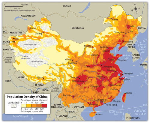
::中国中部和东南部人口稠密、肥沃的河谷与经济条件形成鲜明对比。 丰富的冲积土壤和温和的气温创造了极好的农田,为不断增长的人口提供了巨大的粮食生产。Most of China’s population lives in its eastern region, called China Proper, with type C climates, fresh water, and good soils. China Proper has dense population clusters that correspond to the areas of type C climate that extend south from Shanghai to Hong Kong. Around the world, most humans have gravitated toward type C climates. These climates have produced fertile agricultural lands that provide an abundance of food for the enormous Chinese population.
::中国大部分人口都生活在东部地区,被称为“中国适当 ” , 拥有C型气候、淡水和良好的土壤。 中国适当拥有大量人口,它们与从上海向南延伸到香港的C型气候地区相对应。 在世界各地,大多数人类都向C型气候倾斜。 这些气候创造了肥沃的农业用地,为庞大的中国人口提供了丰富的食物。Shanghai is the most populous city in the world.
::上海是世界上人口最多的城市
To the south, the temperatures are warmer, with hot and humid summers and dry, warm winters. The climates of China Proper are conducive for human habitation, which has transformed the region into a highly populated human community. The North China Plain at the mouth of the Yellow River ( Huang He River ) has rich farmland and is the most densely populated region in China.
::南方的气温比较暖和,夏季炎热潮湿,冬季干燥,冬季温暖,中国的气候有利于人类居住,使中国成为人口稠密的人类社区,黄河口北中平原拥有丰富的农田,是中国人口稠密的地区。The North China Plain is based on the deposits of the Yellow River and is the largest alluvial plain of China.
::北中平原以黄河矿床为基础,是中国最大的冲积平原。
Northwest of Beijing is Inner Mongolia and the Gobi Desert, a desert that extends into the independent country of Mongolia. Arid type B climates dominate the region all the way to the southern half of Mongolia. The northern half of Mongolia is colder with continental type D climates. In the higher elevations of the highlands in western Mongolia, there is a section of type H highland climates.
::北京西北是内蒙古和戈壁沙漠,沙漠延伸至独立的蒙古国,B型干旱气候在蒙古南半部一直以该区域为主,蒙古北半部较冷,大陆气候为D型,蒙古西部高原高海拔地区有一部分H型高地气候。Its climate and location identify Mongolia as a landlocked country in the northern latitudes with a low level of precipitation. The areas of type D climate that extend north from Beijing through Northeast China at times receive more precipitation than northern Mongolia. Northeast China features China’s great forests and excellent agricultural land. Many of China’s abundant natural mineral resources are found in this area. Balancing mineral extraction with the preservation of agricultural land and timber resources is a continual concern.
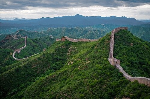
::蒙古的气候和地理位置表明蒙古是北纬地区内陆国,降水量低。 从北京到东北中国向北延伸的D型气候地区有时比北蒙古地区降水量多。 东北中国的森林面积大,农田肥沃。 中国丰富的天然矿产资源都存在于这一地区。 矿物开采与农业用地和木材资源保护的平衡是一个持续的问题。Lying north of the Great Wall and encompassing the autonomous region of Inner Mongolia is the vast Mongolian steppe, which includes broad flat grasslands that extend north into the highlands. North China includes the Yellow River basin as well as the municipalities of Beijing and Tianjin. Areas around parts of the Yellow River are productive agricultural lands, including vast areas of loess that have been terraced for cultivation. Loess is fine silt or windblown soil that is yellow in color in this region. Deciduous forests continue to exist in this region, despite aggressive clearcutting for agricultural purposes. The Great Wall of China sits on top of the hills in this region.
::位于长城以北,覆盖内蒙古自治区的蒙古大片草原是蒙古大片草原,包括向北延伸至高原的大片平坦草原,北中国包括黄河流域以及北京和天津市,黄河部分地区为生产性农地,包括大片耕地,大片露天露天露天露天露天露天露天露天露天露天露天露天露天露天露天露天露天露天露天露天露天。The Great Wall of China is a series of fortifications made of stone, brick, tamped earth, wood, and other materials.
::中国长城是由石块、砖块、铁土、木柴和其他材料组成的一系列工事。
Most of western China is arid, with a type B climate. Western China has large regions like the Takla Makan Desert that are uninhabited and inhospitable because of hot summers and long cold winters exacerbated by the cold winds sweeping down from the north. In a local Uyghur language, the name Takla Makan means “ You will go in but you will not go out .” To the far west are the high mountains bordering Central Asia that restrict travel and trade with the rest of the continent. Northwestern China is a mountainous region featuring glaciers, deserts, and basins.
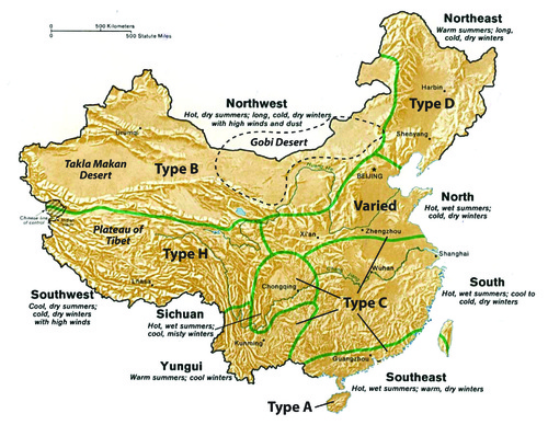
::中国西部大部分是干旱地区,气候为B型;中国西部大片地区,如Takla Makan沙漠,由于炎热的夏季和寒冷的寒冬,北方的寒风加剧了这些地区的居住条件和居住条件差。用当地的维吾尔语来说,Takla Makan这个名字的意思是“你将进去,但你不会出去 ” 。 在远西地区,与中亚接壤的高山限制了与该大陆其他地区的往来和贸易。 西北地区是一个由冰川、沙漠和盆地组成的山区。China and its main climate regions
::中国及其主要气候区域
The central portion of China Proper is subtropical. This large region includes the southern portion of the Yangtze River and the cities of Shanghai and Chongqing. Alluvial processes give this area excellent agricultural land. Its climate is warm and humid in the summers with mild winters. Monsoons create well-defined summer rainy seasons.
::中国中部是亚热带地区,包括长江南部、上海市、重庆市等大地区,冲积潮流为该地区提供了优良农田,夏季气候温暖潮湿,冬季温和,季风造就了界定明确的夏季雨季。Tropical China lies in the extreme south and includes Hainan Island and the small islands that neighbor it. Annual temperatures are higher here than in the subtropical region and rainfall amounts brought by the summer monsoons are substantial. This area is characterized by low mountains and hills.
::热带中国位于最南端,包括海南岛及其邻近的小岛。 这里的年气温高于亚热带地区,夏季季风带来的降雨量也很大。 该地区以低山和低山为特征。Hainan is the smallest and southernmost province of the People's Republic of China (PRC), consisting of various islands in the South China Sea.
::海南省是中华人民共和国最小、最南端的省,由南海各岛屿组成。River Basins of China
::中国河流流域There are two major river systems that provide fresh water to the vast agricultural regions of the central part of China Proper. The Yellow River is named after the light-colored silt that washes into the river. It flows from the Tibetan highlands through the North China Plain into the Yellow Sea. Dams, canals, and irrigation projects along the river provide water for extensive agricultural operations. Crops of wheat, sorghum, corn, and soybeans are common with vegetables, fruit, and tobacco grown in smaller plots.
::黄河以冲入黄河的浅色淤泥命名,从西藏高原经北中平原流入黄海,大坝、运河和沿河灌溉项目为广泛的农业作业提供用水,小麦、高梁、玉米和大豆作物与小块土地上种植的蔬菜、水果和烟草相同。The North China Plain has to grow enough food to feed its one thousand people per square mile average density. This plain does not usually produce a food surplus because of the high demand from the large population of the region. Beijing borders the North China Plain. Its nearest port, Tianjin, continues to expand and grow, creating an economic center of industrial activity that relies on the peripheral regions for food and raw materials. Cotton is an example of a key industrial crop grown here.
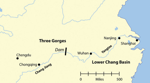
::北中平原必须种植足够的粮食来养活每平方英里平均密度1 000人。 由于该地区广大人口的高需求,该平原通常不会产生粮食盈余。 北京与北中平原接壤。 其最近的港口天津继续扩张和增长,创建了依赖周边地区的食品和原材料的经济活动中心。 棉花就是这里种植的关键工业作物的例子。The Yangtze River flows out of the Tibetan Plateau through the Sichuan Province, through the Three Gorges region and its lower basin into the East China Sea. Agricultural production along the river includes extensive rice and wheat farming. Large cities are located on this river, including Wuhan and Chongqing. Nanjing and Shanghai are situated near the delta on the coast. Shanghai is the largest city in China and is a growing metropolis.
::长江从西藏高原流出,经四川省,经三峡地区及其下游流域流入东海,沿河农业生产包括大米和小麦种植,大都市在河上,包括武汉和重庆,南京和上海靠近沿海三角洲,上海是中国最大的城市,也是不断增长的大都会。The Three Gorges Dam of the Yangtze River is the world’s largest dam. It produces a large percentage of electricity for central China. Oceangoing ships can travel up the Yangtze to Wuhan and, utilizing locks in the Three Gorges Dam, these cargo vessels can travel all the way upriver to Chongqing. The Yangtze River is a valuable and vital transportation corridor for the transport of goods between periphery and core and between the different urban centers of activity. Sichuan is among the top five provinces in China in terms of population and is dependent on the Yangtze River system to provide for its needs and connect it with the rest of China.
::长江三峡大坝是世界上最大的大坝,为中国中部发电量占很大比例。 远洋轮船可以上长江到武汉,利用三峡大坝的锁锁,这些货轮可以一路上河到重庆。 长江是外围和核心之间以及不同城市活动中心之间运输货物的重要运输走廊,四川是中国人口最多的五个省份之一,依靠长江系统满足其需要,并与中国其他地区连接。The region of eastern China that is favorable to large populations is called China Proper.
::中华东部地区人口众多,这个地区被称为“中美省”。
Northeast China was formerly known as Manchuria, named after the Manchu ethnic group that had dominated the region in Chinese history. Two river basins create a favorable industrial climate for economic activity. The lower Liao River Basin and the Songhua River Basin cut through Northeast China. The cities of Harbin and Shenyang are industrial centers located on these rivers. This region is known as the Northeast China Plain.
::中国东北部以前称为满洲,以中国历史上占该区域优势的满洲族群命名,有两个河流流域为经济活动创造了有利的工业环境,下辽河流域和通华河流域横跨中国东北部,哈尔滨和沈阳市是这些河流的工业中心,被称为东北中国平原。It has extensive farming activities located next to an industrial landscape of smokestacks, factories, and warehouses. Considerable mineral wealth and iron ore deposits in the region have augmented the industrial activities and have created serious environmental concerns because of excessive air and water pollution. At its high point in the 1970s, this was China’s main steel production area, but the region is being reduced to a rustbelt since many of China’s manufacturing centers are now being developed in the southern regions of China Proper.
::中国拥有与烟囱、工厂和仓库工业环境相邻的广泛农业活动,该地区丰富的矿产财富和铁矿石矿床扩大了工业活动,并由于过度的空气和水污染造成了严重的环境问题。 在1970年代的高峰时期,这是中国的主要钢铁生产区,但由于中国许多制造中心现在都在中国南部地区开发,该地区正在沦为铁丝网。Shenyang is an important industrial center in China.
::沈阳是中国重要的工业中心
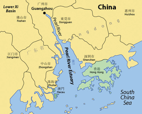
The southernmost region of China Proper is home to the Pearl River Basin, an important agricultural and commercial district. Though smaller in size than the Yangtze River Basin, major global urban centers are located on its estuary, where the mouth of the river flows into the South China Sea. The system includes the Xi River, Pearl River, and their tributaries. As the third-longest river system in China, these rivers process an enormous amount of water and have the second-highest volume of water flow after the Yangtze.
::中国本土最南端地区是珍珠河流域的家园,这是一个重要的农业和商业区,尽管其面积小于长江流域,但全球主要城市中心位于其河口的河口,河口向南中国海流动,包括西河、珠河及其支流。 作为中国第三长的河流系统,这些河流吸收了大量水,在长江之后水流量位居第二位。Guangzhou, Macau, and Hong Kong are the largest cities located here, alongside the rapidly expanding industrial center of Shenzhen. Macau was a former Portuguese colony and Hong Kong was a former British colony. These urban areas are now hubs for international trade and global commerce. Guangzhou is one of the largest cities in China, along with Shanghai, Beijing, Wuhan, and Tianjin. Cantonese heritage and traditions form a foundation for the cultural background of the people who live here.
::广州、澳门和香港是这里最大的城市,还有迅速扩张的深圳工业中心。澳门曾是葡萄牙殖民地,香港曾是英国殖民地。这些城市地区现在是国际贸易和全球商业的中心。广州与上海、北京、武汉和天津一起是中国最大的城市之一。 广州遗产和传统是这里居民文化背景的基础。An estuary is a wide area at the mouth of a river where it meets the sea. Hong Kong is located on the eastern side of the Pearl River Estuary, and the former Portuguese colony of Macau is located on the western side of the waterway.
::港湾位于珍珠河东面,前葡萄牙澳门殖民地位于水路西面。Three Gorges Dam
::三峡谷大坝The Three Gorges Dam on the Yangtze River is known in China as the New China Dam. Its hydroelectric production system is the largest on Earth. The river system is the world’s third longest, after the Nile and the Amazon. Ideas for this project go back to the days just after the last dynasty fell. Plans and development began in the decades before 1994, when the construction of the dam began. The main purposes of the dam are to control the massive flooding along the Yangtze, produce hydroelectric power, and increase shipping capacity along the river.
::长江三峡大坝在中国被称为新中国大坝,其水力发电系统是地球上最大的。 河流系统是继尼罗河和亚马逊河之后世界第三长的河流系统。 这一项目的想法可以追溯到上个王朝倒台之后的几天。 计划和发展始于1994年前的几十年,当时大坝的建设已经开始。 大坝的主要目的是控制长江一带的大规模洪水,生产水力发电,并增加沿河的航运能力。The Yangtze River flows through three deep gorges where a dam has been constructed to stabilize flooding, produce electricity, and support river transportation.
::长江横跨三个深峡谷,在那里修建了水坝,以稳定洪水,发电,支持河运。-
Dam length: 7,661 feet
::水坝长度:7 661英尺 -
Dam height: 610 feet
::水坝高度:610英尺 -
Dam width (at base): 377 feet
::水坝宽度(基底):377英尺 -
Physical construction began: December 14, 1994
::1994年12月14日, -
Construction cost: estimated 39 billion US dollars
::建筑成本:估计390亿美元 -
Estimated surface area of the reservoir: 403 square miles
::储油层估计表面积:403平方英里 -
Estimated length of the reservoir: 375 miles
::储油层估计长度:375英里 -
Capacity of 32 generators totaling 22,500 MW (equivalent to about 20 nuclear power plants the size of the Watts Bar 1, the newest US nuclear reactor)
::总共22 500兆瓦(相当于相当于美国最新核反应堆Watts Bar 1号规模的大约20个核电厂)32台发电机的容量,共22 500兆瓦(相当于美国最新核反应堆Watts Bar 1号)
Before the construction of the dam, flooding along the Yangtze cost thousands of lives and billions of dollars in damage. In 1954, the river flooded, causing the deaths of more than 33,000 people and displacing an additional 18 million people. The giant city of Wuhan was flooded for three months. In 1998, a similar flood caused billions of dollars in damage, flooded thousands of acres of farmland, resulted in more than 1,526 deaths, and displaced more than 2.3 million people.
::在建造大坝之前,长江一带的洪水造成数千人丧生,数十亿美元的损失;1954年,河水淹没,造成33 000多人死亡,1 800万人流离失所;巨型城市武汉洪水淹没了三个月;1998年,类似的洪水造成数十亿美元的损失,数千英亩农田被淹,1 526多人死亡,230多万人流离失所。The dam was rigorously tested in 2009 when a massive flood worked its way through the waterway. The dam was able to withstand the pressure by containing the excess water and controlling the flow downstream. The dam saved many lives and prevented billions of dollars in potential damage. The savings in human lives and in preventing economic damage are projected to outweigh the cost of the dam in only a few decades.
::在2009年,大坝在一次大洪水通过水道时经受了严格的考验;大坝通过控制过量的水和控制下游的水流,承受了压力;大坝挽救了许多生命,防止了数十亿美元的潜在破坏;预计仅几十年内,人命的节省以及经济损失的预防将超过大坝的成本。The dam produces most of the electricity for the lower Yangtze Basin, including Shanghai, the largest city in China. Five years of the dam producing electricity has already paid for about one-third of its construction costs, which is equivalent to burning approximately 150 million tons of coal. This reduces the emission of millions of tons of carbon dioxide, sulfur, and nitrogen oxides into the atmosphere, which reduces air pollution and does not contribute to climate change.
::大坝为下长江流域(包括中国最大的城市上海)生产大部分电力。 发电大坝五年来已经支付了大约三分之一的建设成本,相当于燃烧约1.5亿吨煤炭。 这减少了数百万吨二氧化碳、硫磺和氮氧化物排放到大气中,这减少了空气污染,也无助于气候变化。Heavy freight traffic on the Yangtze was the norm even before the dam was built. In fact, it has the highest rates of transport of any river. The building of the dam has augmented the amount of freight traffic.
::即使在大坝建成之前,长江上的重货运输就一直是正常的,事实上,长江的运输速度最高,大坝的建造增加了货运量。All the positive attributes of the Three Gorges Dam have contributed to the economic development of China. This is a testimony to the engineering and technological capacity of the nation. However, this project has also created its own problems and negative impacts on culture and the environment. By 2008, the number of people forced to relocate from the flooding of the reservoir had reached 1.24 million. Historic villages and hundreds of archaeological sites were flooded. Thousands of farmers had to be relocated to places with less productive soils. Compensation to the farmers for relocation was forfeited because of corruption and fraud. Much of the scenic beauty of the river basin is now under water.
::三个峡谷大坝的所有积极特征都为中国的经济发展做出了贡献,这证明了中国的工程和技术能力,然而,该项目本身也给文化和环境造成了问题和负面影响,到2008年,因水库洪水而被迫搬迁的人数已达124万人,历史上的村庄和数百个考古遗址被淹没,数以千计的农民不得不搬迁到生产力较差的地方,由于腐败和欺诈,丧失了对农民搬迁的补偿,河川流域的风光现在大都在水下。Animal species like the critically endangered Siberian Cranes, who had wintered in the former wetlands of the river, had to find habitat elsewhere. The endangered Yangtze River Dolphin has been doomed to extinction because of the dam and the amplified river activity. The dam restricts the flushing of water pollution and creates a massive potential for landslides along its banks, exacerbating the potential for the silting in of the reservoir and the clogging of the dam’s turbines.
::濒临灭绝的西伯利亚鹤等动物物种曾在河流的原湿地过冬,他们不得不在其他地方寻找栖息地。 濒危的长江海豚由于水坝和河流活动扩大而注定要灭绝。 水坝限制了水污染的冲洗,并造成了沿着河岸滑坡的巨大潜力,加剧了水库淤塞和水坝涡轮机倒塌的可能性。The dam also sits on a fault zone and there is concern that the massive weight of the water in the reservoir could trigger earthquakes that may destroy the dam, with catastrophic consequences. Large development projects tend to have an enormous impact on the people and the environment. The building of the Three Gorges Dam has created controversy, with strong arguments on both sides of the issue. To further complicate the situation, other large dams are being proposed or are under construction along the same river.
::大型开发项目往往对人民和环境产生巨大影响。建造三峡大坝引起了争议,双方都对此问题提出了强烈的论据。为了进一步使情况复杂化,正在或正在沿同一河建造其他大型水坝。Chinese Dynasties and Colonialism
::中国王朝和殖民主义The earliest Chinese dynasty dates to around 2200 B.C.E. It was located in the rich North China Plain. Organized as a political system, Chinese dynasties created the Chinese state, which provided for a continuous transfer of power, ideas, and culture from one generation to another. From 206 to 220 C.E., the Han Dynasty established the Chinese identity. Chinese people became known as People of Han or Han Chinese. The last dynasty, the Qing (Manchu) Dynasty, which ruled between 1644 and 1911, claimed control of a region including all of China, Mongolia, Southeast Asia, and Korea. Dynastic rule ended in China in 1911.
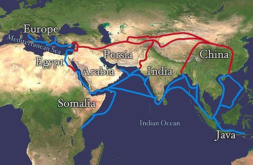
::最早的中国王朝日期大约在公元前2200年左右,位于富饶的北中平原。作为一个政治制度,中国王朝创建了中国,规定权力、思想和文化的一代代相传。从公元前206年到220年,汉王朝建立了中国的特性。中国人被称为汉人或汉人。上一个王朝,即1644年至1911年统治的清(满)王朝,声称控制了包括中国、蒙古、东南亚和韩国全境在内的一个地区。1911年,王朝统治在中国结束。European colonialism arrived in China during the Qing Dynasty. China had been an industrialized state for centuries. Long before the empires of Rome and Greece were at their peak, China's industrial cities flourished with the concepts of clean drinking water, transportation, and technology. Paper, gunpowder, and printing were used in China centuries before they arrived in Europe. The Silk Road, which crossed the often dangerous elevations of the high mountain passes, was the main trading link between China and Europe.
::清朝时期的欧洲殖民主义来到了中国。 几个世纪以来,中国一直是一个工业化国家。 早在罗马和希腊帝国达到高峰之前,中国工业城市就以清洁饮用水、交通和技术的理念蓬勃发展。 纸、火药和印刷品在到达欧洲之前的几个世纪就被中国使用过。 丝绸之路(Silk Road)跨越了高山高山高地,是中国与欧洲之间的主要贸易连接点。The Silk Road was an ancient network of trade routes that connected the East and West.
::丝绸之路是一个古老的贸易路线网络,连接东西方。
European colonial powers met tough resistance in China. They were kept at bay for years. Meanwhile, the Industrial Revolution in Europe, which cranked out mass-produced products at a cheap price, provided an advantage over Chinese production. British colonizers also exported opium, an addictive narcotic, from their colonies in South Asia to China to help break down Chinese culture. By importing tons of opium into China, the British were able to instigate social problems.
::欧洲殖民列强在中国遭遇了激烈的抵抗。 多年来,它们一直处于停滞状态。 与此同时,欧洲工业革命以低廉的价格扭曲了大规模生产的产品,为中国的生产提供了优势。 英国殖民者还从南亚殖民地向中国出口鸦片(一种上瘾的麻醉药物 ) , 以帮助粉碎中国文化。 通过向中国进口成吨的鸦片,英国得以引发社会问题。The first Opium Wars of 1839–1842 ended with Britain gaining an upper hand and laying claim to most of central China. Other European powers also sought to gain a foothold in China. Portugal gained the port of Macau. Germany took control of the coastal region of the rich North China Plain. France carved off part of southern China and Southeast Asia. Russia came from the north to lay claim to the northern sections of China. Japan, which was just across the waterfront from China, took control of Korea and the island of Formosa (now called Taiwan). Claims on China increased as colonialism moved in to take control of the Chinese mainland.
::1839-1842年第一次鸦片战争的结束,英国占上风,对中华大部分国家提出主张。其他欧洲大国也试图在中国获得立足点。葡萄牙获得了澳门港口。德国控制了富饶的北华平原沿海地区。法国割裂了中国南部和东南亚部分地区。俄罗斯从北方来到中国北部,对中国北部地区提出主张。日本刚刚越过中国的海滨,控制了韩国和福摩萨岛(现称台湾 ) 。 随着殖民主义进入控制中国大陆,对中国的索赔增加。Though European powers laid claim to parts of China, they often fought among themselves. China did not produce heavy military weapons as early as the Europeans did and therefore could not fend them off upon their invasion. Chinese culture, which had flourished for 4,000 years, quickly eroded through outside intrusion. It was not until about 1900, when a rebellion against foreigners (known as the Boxer Rebellion) was organized by the Chinese people, that the conflict reached recognizable dimensions. The Qing Dynasty dissolved in 1911, which also signified an end to the advancements of European colonialism, even though European colonies remained in China.
::尽管欧洲列强向中国部分地区宣战,但它们经常相互作战。 早在欧洲人入侵时,中国并没有生产重军事武器,因此无法阻止它们。 4000年来蓬勃发展的中国文化由于外来入侵而迅速消亡。 直到1900年左右,中国人民才组织一场针对外国人的叛乱(称为“拳击反抗 ” ) , 冲突达到了可识别的地步。 1911年,清朝解体,这也标志着欧洲殖民主义的终结,尽管欧洲殖民地仍在中国。Three-Way Split in China
::中国的三瓦分裂European colonialism in China slowed after 1911, and World War I severely weakened European powers. The Japanese colonizers, on the other hand, continued to make advancements. Japan did not have far to travel to resupply troops and support its military. In China, a doctor by the name of Dr. Sun Yat-sen promoted the independent Chinese Republic, free from a dynastic rule, Japanese, or European colonial influence. Political parties of Nationalists and Communists also worked to establish the republic. Dr. Sun Yat-sen died in 1925. The Nationalists, under the leadership of Chiang Kai-shek, defeated the Communists and established a national government. Foreigners were evicted. The Communists were driven out of politics.
::1911年后,中国的欧洲殖民主义减慢,而第一次世界大战则严重削弱欧洲列强。另一方面,日本殖民者继续取得进步。日本没有远足去补给军队和支持其军队。在中国,一位名叫孙亚森博士的医生在没有王朝统治、日本或欧洲殖民影响的情况下,推动独立的中华民国。民族主义政党和共产党也在努力建立共和国。孙雅森博士在1925年去世了。在清开石的领导下,民族主义者击败了共产党,成立了民族政府。外国人被逐出。共产党被赶出了政治。Both the Republic of China (ROC) and the People’s Republic of China (PRC) consider Dr. Sun Yat-sen to be a famous Chinese historical figure.
::中华民国(中华民国)和中华人民共和国(中华民国)都认为孙Yat-sen博士是中国著名历史人物。
Nationalists, Communists, and Japan conducted a three-way war over the control of China. Japan’s military took control of parts of Northeast China, known as Manchuria, and made advancements on the eastern coast. Nationalists defeated the Communists for power and were pushing them into the mountains. The Chinese people were in support of the two parties working together to defeat the Japanese.
::民族主义者、共产主义者和日本对中国的控制权进行了三重战争。 日本军队控制了中国东北部部分地区(即满洲 ) , 并在东海岸取得了进步。 民族主义者击败了共产主义者掌权,并将他们推向山区。 中国人民支持两党合作击败日本。The Long March of 1934 was a 6,000-mile retreat by the Communists through rural China, pursued by Nationalist forces. The people of the countryside gave aid to the efforts of the Communists. The Chinese were primarily interested in the defeat of Japan, a country that was brutally killing massive numbers of China’s people in their aggressive war.
::1934年3月的长征是共产党通过中国农村进行6000英里的撤退,由民族主义势力追赶。 乡下人民为共产党的努力提供了援助。 中国人主要关心日本的失败,日本在中国的侵略战争中残酷地杀害了大批中国人民。In 1945, the defeat of Japan in World War II by the United States changed many things. Japan’s admission of defeat prompted the end of Japanese control of territory in China, Taiwan, Korea, Southeast Asia, and the Pacific. By 1948, the Communists, who were becoming well organized, were defeating the Nationalists. Chiang Kai-shek gathered his people and what Chinese treasures he could and fled by boat to the island of Formosa (Taiwan), which in 1945 had just been freed from Japan.
::1945年,美国在二战中击败日本改变了许多事情。 日本承认失败促使日本结束了对中国、台湾、韩国、东南亚和太平洋领土的控制。 到1948年,组织严密的共产主义者正在击败民族主义者。 蒋介石聚集了日本人民和他能够乘船逃到1945年刚刚从日本获得释放的福摩萨岛(台湾 ) 的中国宝藏。Taiwan was declared the official Republic of China (ROC). The Communists took over the mainland government. In 1949, Communist leader Mao Zedong declared the establishment of the People’s Republic of China (PRC) with its capital in Peking (Beijing). Japan was devastated by US bombing and defeated in World War II. Its infrastructure destroyed and its colonies lost, Japan had to begin the long process of rebuilding its country.
::台湾被宣布为正式的中华民国(ROC ) 。 共产党占领了大陆政府。 1949年,共产党领导人毛泽东宣布成立中华人民共和国(PRC ) , 首都在北京(北京 ) 。 日本被美国轰炸摧毁,在二战中被击败。 其基础设施被摧毁,殖民地被毁,日本不得不开始重建国家的长期进程。Korea was finally liberated from the Chinese dynasties and Japanese colonialism but began to experience an internal political division. Political structures in the second half of the 20th century in East Asia were vastly different from the political structures that had been in place when the century began.
::韩国最终从中国王朝和日本殖民主义中解放出来,但开始经历内部政治分裂。 20世纪下半叶东亚的政治结构与本世纪开始时的政治结构大不相同。
Key Takeaways
::密钥外出-
China is the largest country in physical area and in population in East Asia. The realm is isolated by the high mountains in the west, which cause a major rain shadow and desert conditions in the western regions. Mongolia is the only landlocked country. The other countries and territories are located along the Pacific Rim.
::中国是东亚大陆面积和人口面积最大的国家,西部高山与中国隔绝,造成西部地区大雨影和沙漠条件,蒙古是唯一内陆国,其他国家和地区位于太平洋周边地区。 -
Robust population growth has been supported by adequate food production in the major river valleys and coastal regions of East Asia. Coastal areas receive adequate precipitation and allow access to fishing for human activities.
::东亚主要河谷和沿海地区的充足粮食生产支持了强劲的人口增长,沿海地区有充足的降水量,可以从事人类活动的捕鱼活动。 -
The Three Gorges Dam was constructed on the Yangtze River to control flooding, generate electricity, and support shipping. The dam is the largest in the world. Downsides of the dam have included the relocation of human settlements, erosion, and other environmental concerns.
::三峡谷大坝建在扬泽河上,以控制洪水、发电和支持航运,大坝是世界上最大的大坝,大坝的下坡包括人类住区迁移、侵蚀和其他环境问题。 -
Colonialism infiltrated China and challenged its last dynasty. By 1911, both the dynasty and European colonialism were in demise. In a three-way battle for power in China, the Communists emerged in 1949 to take control. The Nationalists fled to Formosa to form their own government.
::1911年,中国的王朝和欧洲殖民主义都消亡了。 在中国的三战中,共产党于1949年崛起以掌权。 民族主义者逃到福摩萨组建自己的政府。
Vocabulary Terms
::词汇术语术语Chapter 10.1 Introducing the Realm
::第10.1章 介绍王国aquaculture
::水产养殖The cultivation or farming of aquatic plants and animals.
::水生植物和动物的种植或耕作。Boxer Rebellion
::拳击兵叛乱An uprising in China in 1900 , spurred by angry Chinese militants, the "Boxers" , over foreign control; several hundred Europeans, Ch ristians , and Chinese died.
::1900年在中国爆发起义, 由愤怒的中国好战分子(Boxers)挑起, 由外国控制引发; 几百名欧洲人、基督徒和中国人丧生。developed country
::发达国家(发达国家)A wealthy country with an advanced economy, usually have many industries and provide a comfortable way of life for most of its people.
::一个拥有先进经济的富裕国家,通常拥有许多产业,为大多数人民提供舒适的生活方式。developing country
::发展中国家A poore r country with a less advanced economy. In general, developing countries are trying to increase their industries and improve life for their citizens.
::一个经济较不发达的较贫穷国家,总的来说,发展中国家正在努力增加其工业,改善公民的生活。Huang He
::黄黄河Fourth longest river, runs through the fertile region of East Asia .
::第四条最长的河流穿过东亚肥沃地区。hydroelectricity
::水电El ectricity that is generated from the power of moving water.
::电力来自移动水的动力。monsoon
::季风A seasonal wind, especially in South Asia.
::季节性风,特别是南亚的季节性风。North China Plain
::北中平原O ne of the most fertile regions of China .
::中国最肥沃的地区之一plateau
::高原A raised area , such as a hill or mountain, with a mostly level top .
::高地,如山丘或山峰,其顶层大多是高地。Pacific Rim
::环太平洋环环环An economic and social region that includes countries of Ea st Asia, Southeast Asia, Australia, New Zealand, Chile and the west coast of the United States.
::经济社会区域包括东亚、东南亚、澳大利亚、新西兰、智利和美国西海岸。Three Gorges Dam
::三峡谷大坝Built to control floodin g of the Chang Jiang River it also produces a large percentage of the electricity for central China.
::为了控制昌江河的洪涝,中国中部的电力也占大部分。typhoon
::台台风Tropical storm that occurs in the western Pa cific. Also known as a hurricane or tropical cyclone.
::西太平洋发生的热带风暴,也称为飓风或热带旋风。Yangtze River
::长江江(Chang J iang )
:张江)
The longest river in Asia, runs 3,900 miles from Xizang (Tibet) to the East China Sea.
::亚洲最长的河流,从西赞(西藏)到东中国海有3 900英里。Applying Knowledge
::应用知识Discussion and Study Questions
::讨论和研究问题-
Outline the countries or territories that make up the region known as East Asia.
::概述构成称为东亚的区域的国家或领土。 -
How is East Asia separated from the rest of Asia? How did this keep the realm isolated for many centuries?
::东亚如何与亚洲其他地区隔绝? 这又如何让这个区域隔绝了几个世纪? -
What is the only landlocked country in East Asia? Describe its physical features.
::东亚唯一的内陆国是什么? -
What are the main climate types in each of the countries in East Asia?
::东亚各国的主要气候类型是什么? -
Where are the four main river basins in China Proper? How do they contribute to China’s development?
::中国的四个主要河流流域在哪里?它们如何为中国的发展作出贡献? -
What are the three main benefits of the Three Gorges Dam? What are three of the negative impacts?
::三峡大坝的三个主要好处是什么? -
What was significant about the Han and Qing Dynasties? When did dynastic rule end in China?
::汉王朝和清朝有什么意义? -
How did the British attempt to break down Chinese culture? What was China’s response?
::英国如何试图粉碎中国文化? 中国的反应是什么? -
What was the relationship between Japan, Korea, and China before World War II?
::第二次世界大战前日本、韩国和中国之间的关系是什么? -
What was the three-way split in China about? What happened to each of the three groups?
::中国的三条分道扬镳是怎么回事?这三组人中每一组都发生了什么呢?
Real-World Geography Exercise
::现实世界地理演习-
Using
, complete the following activities:
-
Locate each place on the bulleted list below.
::在下面的子弹名单上 找到每个地方 -
Find the nearest city with an international airport in proximity to each location on the bulleted list below.
::找到最近的城市,在下面子弹清单上每个地点附近有一个国际机场。 -
Calculate the distance and travel time by plane to each city from the
in Miami, Florida.
::计算从佛罗里达州迈阿密到每个城市的 飞机距离和旅行时间
::使用以下活动,完成以下活动: 确定以下子弹清单上的每个地点; 找到最近的城市, 在下面子弹清单上的每个地点附近有一个国际机场。 计算从佛罗里达州迈阿密飞往每个城市的飞机距离和飞行时间。 -
Locate each place on the bulleted list below.
-
Using
, determine the latitude and longitude for each location on the bulleted list below.
::使用,确定以下子弹列表中每个位置的纬度和经度。 -
Be prepared to share and discuss your answers.
::准备分享和讨论你的答案
-
Altay Mountains
::阿尔泰山 -
Chang Jiang River
::张江江 -
China Proper
::中国 -
Chongqing
::重庆 -
Formosa
::形态 -
Gobi Desert
::戈壁沙漠 -
Guangzhou
::广州 -
Hainan Island
::海南岛 -
Harbin
::哈尔滨 -
Hong Kong
::香港香港 -
Huang He River
::黄河 -
Inner Mongolia
::内蒙古 -
Karakoram Ranges
::卡拉科拉姆山脉 -
Liao River
::廖江 -
Macau
::澳门 澳门 -
Nanjing
::南京 -
North China Plain
::北中平原 -
Northeast China Plain
::中国东北部平原 -
Pamirs
::帕米尔 -
Pearl River
::珠珠河 -
Shanghai
::上海 -
Shenyang
::沈阳 -
Shenzhen
::深圳 -
Songhua River
::宋华江 -
Taiwan
::台台 -
Takla Makan Desert
::塔克拉马坎沙漠 -
Three Gorges Dam
::三峡谷大坝 -
Tianjin
::天进 -
Tian Shan
::天山 -
Tibet
::西藏 -
Western China
::中国西部 -
Wuhan
::武汉 -
Xizang
::Xizang Xizang -
Yangtze River
::长江江 -
Yellow River
::黄河
Current Events
::当前事件Videos for Geography Enrichment
::地理丰富视频Helpful Websites for the Study of Geography
::地理研究有用网站is an encyclopedia funded by the Canadian government covering all branches of knowledge. Their scholarly collection includes interactive materials.
::该百科全书由加拿大政府资助,涵盖所有知识分支,其学术收藏包括交互式材料。provides information on the people, history, government, economy, energy, geography, communications, transportation, military, and transnational issues for the world's entities.
::向世界各实体提供关于人民、历史、政府、经济、能源、地理、通信、运输、军事和跨国问题的资料。is a US government website where you can find federal legislation, past and present, as well as information about the US legal system.
::是一个美国政府的网站,您可以在此找到过去和现在的联邦立法以及关于美国法律制度的信息。is a government agency website that provides current news, resources, topics of interest, information about drugs, careers in the DEA, and a tip hotline.
::是一个政府机构网站,提供最新消息、资源、感兴趣的话题、毒品信息、在缉毒局的职业以及一条小费热线。is the largest library in the world and provides manuscripts, files, information, pictures, and videos.
::图书馆是世界上最大的图书馆,提供手稿、文件、信息、图片和录像。is a US government agency website that allows users to search for and retrieve satellite images of Earth.
::这是一个美国政府机构的网站,用户可以搜索和检索地球的卫星图像。is a US government website that provides historical documents, photos, records, publications, and educator resources.
::这是一个美国政府网站,提供历史文件、照片、记录、出版物和教育资源。is a US government agency website that provides weather-related information and ocean research.
::是一个提供气象信息和海洋研究的美国政府机构网站。is a website by the United States Geological Survey and other federal, state, and local agencies that delivers topographic information for the United States.
::这是美国地质调查局和其他联邦、州和地方机构为美国提供地形信息的网站。is a massive central data source and a handy way to graphically compare nations.
::是一个庞大的中央数据源,是用图形比较国家的一种方便方式。is a website that measures most locations in the world for air pollution in real time.
::是一个实时测量世界上大多数空气污染地点的网站。is a unique statistical database, which allows you to research and compare a multitude of different data on US states.
::这是一个独特的统计数据库, 使你能够研究和比较关于美国各州的多种不同数据。is an international organization founded in 1945 and made up of 193 member states. The UN maintains international peace and security, protects human rights, delivers humanitarian aid, promotes sustainable development, and upholds international law.
::联合国是一个国际组织,成立于1945年,由193个成员国组成。 联合国维护国际和平与安全,保护人权,提供人道主义援助,促进可持续发展,维护国际法。is a US government agency that provides a population clock, data, surveys, statistics, a library with information and infographics, news about the economy, and much more.
::这是一个美国政府机构,它提供人口钟、数据、调查、统计、一个拥有信息和信息资料的图书馆、关于经济的新闻,以及更多。is a US government agency website that provides scientific information about the natural hazards that threaten lives, the natural resources we rely on, the health of our ecosystems and environment, and the impacts of climate and land-use change.
::这是一个美国政府机构的网站,提供科学信息,说明威胁生命的自然危害、我们赖以生存的自然资源、生态系统和环境的健康以及气候和土地使用变化的影响。is a US government website that provides the latest presidential news, information about the budget, policy, defense, and many more topics.
::提供最新总统新闻、预算、政策、国防等资讯, 以及更多议题。is under the United Nations and provides leadership on matters critical to health, shapes the research agenda on health, and monitors the health situation and assessing health trends around the world. Their website provides information on the state of health around the world, outbreaks, current health news, and more.
::网站提供世界各地卫生状况、疫情爆发、最新卫生新闻等信息。is an intergovernmental organization that regulates international trade. The website provides information on the history of the multilateral trading system, featured videos, news and events, trade topics, and more.
::该网站提供关于多边贸易体系历史的信息、视频、新闻和事件、贸易专题等等。 -
Outline the countries and territories that are included in East Asia.