11.4 太平洋岛屿(2天)
Section outline
-
Chapter Challenges
::章次 挑战-
List the three main areas of the South Pacific.
::列出南太平洋的三个主要地区。 -
Explain the difference between low islands and high islands.
::解释低岛和高岛之间的区别。 -
List which islands remain under the control of France, the United Kingdom, New Zealand, or the United States.
::法国、联合王国、新西兰或美国仍然控制着哪些岛屿的清单。 -
Describe the primary economic activities of the islands in the realm.
::描述群岛在本领域的主要经济活动。 -
Summarize the main environmental concerns of the islands in each region.
::概述了每个区域岛屿的主要环境问题。
Student Learning Objectives
::学生学习目标TEKS Regional Unit 11 Oceania: Chapter 11.4 The Pacific Islands
::TERS 11区域股 大洋洲:第11.4章 太平洋岛屿WG.1A Analyze the effects of physical and human geographic patterns and processes on the past and describe their impact on the present, including significant physical features and environmental conditions that influenced migration patterns and shaped the distribution of culture groups today.
::WG.1A 分析物理和人类地理模式和过程对过去的影响,并描述其对目前的影响,包括影响移徙模式并影响当今文化群体分布的重要物理特征和环境条件。WG.2A Describe the human and physical characteristics of the same regions at different periods of time to evaluate relationships between past events and current conditions.
::WG.2A 描述不同时期同一区域的人的和自然的特征,以评估过去事件与当前状况之间的关系。WG.3A Explain weather conditions and climate in relation to annual changes in Earth-Sun relationships.
::WG.3A 结合地球-太阳关系的年度变化解释天气条件和气候。WG.3B Describe the physical processes that affect the environments of regions, including weather, tectonic forces.
::WG.3B 描述影响区域环境的物理过程,包括天气、构造力。WG.4A Explain how elevation, latitude, wind systems, ocean currents, position on a continent, and mountain barriers influence temperature, precipitation, and distribution of climate regions.
::WG.4A 解释高海拔、纬度、风力系统、洋流、大陆位置、山地屏障如何影响气候区域的温度、降水量和分布。WG.4B Describe different landforms and the physical processes that cause their development.
::WG.4B 描述不同的土地形态和导致其发展的物理过程。WG.4C Explain the influence of climate on the distribution of biomes in different regions.
::WG.4C 解释气候对不同区域生物群落分布的影响。WG.5A Analyze how the character of a place is related to its political, economic, social, and cultural elements.
::WG.5A 分析一个地方的特性如何与其政治、经济、社会和文化因素相关。WG.6A Locate and describe human and physical features that influence the size and distribution of settlements.
::WG.6A 确定并描述影响定居点规模和分布的人文和物理特征。WG.6B Explain the processes that have caused changes in settlement patterns, including urbanization, transportation, access to and availability of resources, and economic activities.
::WG.6B 解释导致住区模式变化的进程,包括城市化、运输、获得和获得资源以及经济活动。WG.8A Compare ways that humans depend on, adapt to, and modify the physical environment, including the influences of culture and technology.
::WG.8A 比较人类依赖、适应和改变自然环境的方式,包括文化和技术的影响。WG.8B Describe the interaction between humans and the physical environment and analyze the consequences of extreme weather and other natural disasters such as El Nino, floods. tsunamis, and volcanoes.
::WG.8B 描述人类与自然环境之间的相互作用,分析极端天气和厄尔尼诺、洪水、海啸和火山等其他自然灾害的后果。WG.8C Evaluate the economic and political relationships between settlements and the environments, including sustainable development and renewable/non-renewable resources.
::WG.8C 评价住区与环境之间的经济和政治关系,包括可持续发展和可再生/不可再生资源。WG.9A Identify physical and/or human factors such as climate, vegetation, language, trade networks, political units, river systems, and religion that constitute a region.
::WG.9A 查明构成区域的自然和/或人类因素,如气候、植被、语言、贸易网络、政治单位、河流系统和宗教。WG.10C Compare the ways people satisfy their basic needs through the production of goods and services such as subsistence agriculture versus commercial agriculture or cottage industries versus commercial industries.
::WG.10C 比较人们通过生产商品和服务满足其基本需要的方式,如自给农业,而不是商业农业或家庭手工业,而不是商业工业。WG.10D Compare global trade patterns over time and examine the implications of globalization, including outsourcing and free trade zones.
::WG.10D 比较一段时间的全球贸易格局,审查全球化的影响,包括外包和自由贸易区。WG.11B Identify factors affecting the location of different types of economic activities, including subsistence and commercial agriculture manufacturing, and service industries.
::WG.11B 查明影响不同类型经济活动地点的因素,包括维持生计和商业农业制造业以及服务业。WG.11C Assess how changes in climate, resources, and infrastructure (technology, transportation, and communication) affect the location and patterns of economic activities.
::WG.11C 评估气候、资源和基础设施(技术、运输和通信)的变化如何影响经济活动的地点和模式。WG.18A Analyze cultural changes in specific regions caused by migration, war, trade, innovations, and diffusion.
::WG.18A 分析移徙、战争、贸易、创新和传播在特定区域造成的文化变化。WG.18C Identify examples of cultures that maintain traditional ways, including traditional economies.
::WG.18C 查明保持传统方式的文化实例,包括传统经济。WG.18D Evaluate the spread of cultural traits to find examples of cultural convergence and divergence such as the spread of democratic ideas, US-based fast-food franchises, the English langue, technology, or global sports.
::WG.18D 评价文化特征的传播情况,以寻找文化趋同和差异的例子,例如民主思想的传播、以美国为基地的快餐专营、英语朗格、技术或全球体育。WG.21A Analyze and evaluate the validity and utility of multiple sources of geographic information such as primary and secondary sources, aerial photographs, and maps.
::WG.21A 分析和评价多种地理资料来源,例如主要和次要资料来源、航空照片和地图的有效性和效用。WG.21C Create and interpret different types of maps to answer geographic questions, infer relationships, and analyze change.
::WG.21C 创建和解释不同类型的地图,以回答地理问题、推断关系和分析变化。WG.22A Design and draw appropriate graphics such as maps, diagrams tables, and graphs to communicate geographic features, distributions, and relationships.
::WG.22A 设计和绘制适当的图形,如地图、图表表和图表,以交流地理特征、分布和关系。WG.22B Generate summaries, generalizations, and thesis statements supported by evidence.
::WG.22B 编写摘要、概述和有证据佐证的论文陈述。WG.22E Create original work using proper citations and understanding and avoiding plagiarism.
::WG.22E 利用适当的引证和理解并避免损害,创建原创工作。The Pacific Islands
::太平洋岛屿Introducing the Realm
::介绍王国The Pacific realm is home to many islands and island groups. The largest island is New Guinea, which is home to most of the realm’s population. Many of the Pacific islands have become independent countries, while others remain under the authority of other countries. The was a battleground between the Japanese and American forces and had an impact on many of the islands. The Hawaiian Islands became the 50th US state in 1959.
::太平洋是许多岛屿和岛屿群的家园。 最大的岛屿是新几内亚,是本岛大多数人口的家园。 许多太平洋岛屿已成为独立国家,而另一些则仍然处于其他国家的统治之下。 太平洋是日本和美国军队之间的战场,对许多岛屿产生了影响。 夏威夷群岛在1959年成为美国第50个州。The many islands can be divided into three main groups based on physical geography, local inhabitants, and location: Melanesia, Micronesia, and Polynesia. Indigenous cultural heritage remains strong in the South Pacific, but Western culture has made deep inroads into people’s lives. The globalization process bears heavily on the economic conditions that influence the cultural dynamics of the Pacific.
::许多岛屿可以基于地理、当地居民和地理位置分为三大类:美拉尼西亚、密克罗尼西亚和波利尼西亚。 南太平洋的土著文化遗产依然强劲,但西方文化已经深入人民的生活。 全球化进程对影响太平洋文化动态的经济状况有着重大影响。Islands or island groups that remain under outside political jurisdiction are the most influenced by European or American cultural forces. Western trends in fast food, pop music, clothing styles, and social customs often dominate television, radio, and the cinema. Western culture takes the focus away from the traditional indigenous culture and heritage of the people who inhabited these isolated islands for centuries.
::仍处于政治管辖之外的岛屿或岛屿群体受欧洲或美国文化力量的影响最大。 西方快餐、流行音乐、服装风格和社会习俗的趋势往往支配着电视、广播和电影。 西方文化忽视了生活在这些孤立岛屿上数百年的人的传统土著文化和遗产。Traditionally, the islands were economically self-sufficient. Fishing and growing crops were the main economic activities, and nearby islands often established trade and exchanged natural resources. Fishing has been one of the most common ways of supporting the economy. There have been changes in the national boundaries to protect offshore fishing rights around each sovereign entity. Many waters have been overfished, consequently reducing the islands’ ability to provide food for their people or to gain national wealth. An increase in population and the introduction of modern technologies has brought about a dependency on the world’s core areas for economic support.
::传统上,群岛在经济上是自给自足的。 渔业和种植作物是主要经济活动,附近岛屿经常建立贸易和交换自然资源。 渔业是支持经济的最常见方式之一。 国家边界的变化是为了保护每个主权实体周围的近海捕鱼权。 许多水域被过度捕捞,从而削弱了岛屿为人民提供食物或获得国家财富的能力。 人口增长和现代技术的引进导致依赖世界核心地区提供经济支持。The Pacific is a peripheral realm with little to offer to the core areas economically. In recent decades, some national wealth has been gained from the mining of substances as phosphates on a few of the islands. The main resources available are a pleasant climate, beautiful beaches, and tropical island terrain, all of which can be attractive to tourists and people from other places.
::太平洋是一个边缘地区,在经济上对核心地区几乎没有什么好处。 近几十年来,一些国家的财富来自于在几个岛屿开采磷酸盐等物质。 现有的主要资源是舒适的气候、美丽的海滩和热带岛屿地形,所有这些都对游客和其他地方的人有吸引力。Tourism is a growing sector of the service industry and a major means of gaining wealth for various island groups. To attract tourism, the islands must invest in the necessary infrastructure, such as airports, hotels, and supporting services. Long distances between islands and remote locations make tourism transportation expensive. Not every island has the funding to support these expenditures to draw tourists to their location.
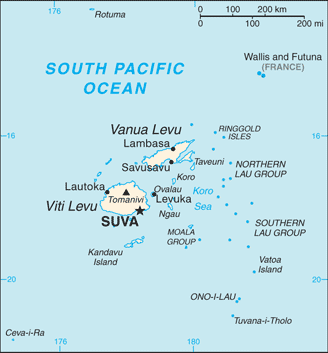
::旅游业是服务业中不断增长的一个部门,也是各岛屿群体获得财富的主要手段,为了吸引旅游业,各岛屿必须投资于必要的基础设施,如机场、旅馆和支助服务,岛屿与偏远地点之间的距离太远,旅游运输费用昂贵,并非每个岛屿都有资金支持这些支出,将游客吸引到它们所在的地点。Melanesia
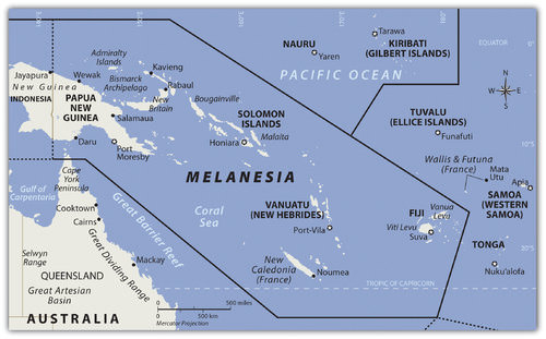
::美美拉尼西亚Map of Melanesia
::美拉尼西亚地图
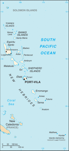
The region of the Pacific north of Australia that borders Indonesia to the east is called Melanesia . The name originally referred to people with darker skin but does not adequately describe the region’s current ethnic diversity. The main island groups include , , , the , and . All are independent countries except New Caledonia, which is under the French government. The island of New Guinea is shared between Papua New Guinea and Indonesia. Many islands on the eastern side of Indonesia share similar characteristics but are not generally included in the region of Melanesia.
::与东邻印度尼西亚的澳大利亚北部太平洋地区称为美拉尼西亚,最初名称指皮肤较深的人,但没有适当描述该地区目前的种族多样性。主要岛屿群体包括法国政府属下的新喀里多尼亚,所有都是独立国家。新几内亚岛由巴布亚新几内亚和印度尼西亚共有。印度尼西亚东部的许多岛屿具有相似的特征,但一般不包含在美拉尼西亚地区。Independent Countries of Melanesia
::美拉尼西亚独立国家-
Fiji
::斐济 -
Papua New Guinea
::巴布亚新几内亚 巴布亚新几内亚 -
Solomon Islands
::所罗门群岛 所罗门群岛 所罗门群岛 -
Vanuatu
::瓦努阿图 瓦努阿图
Other Island Groups
::其他岛屿群-
New Caledonia (
France
)
::新喀里多尼亚(法国)
Papua New Guinea
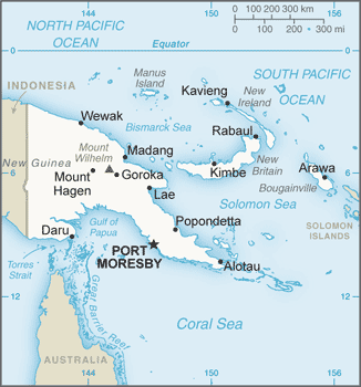
::巴布亚新几内亚 巴布亚新几内亚Map of Papua New Guinea
::巴布亚新几内亚地图
Papua New Guinea is the largest country in the Pacific realm and therefore the largest in Melanesia. It is diverse in both physical terrain and human geography. The high mountains of the interior reach 14,793 feet. Snow has been known to fall in the higher elevations even though they are located near the equator. Many local groups inhabit the island, and more than 700 separate languages are spoken, more than in any other country in the world. Indigenous traditions create strong centripetal forces. Papua New Guinea received independence in 1975 and is working toward fitting into the global community.
::巴布亚新几内亚是太平洋地区最大的国家,因此也是美拉尼西亚最大的国家,地貌和人文地理各异,内地高山面积达14 793英尺,据知雪落在高海拔,尽管位于赤道附近,许多当地群体居住在岛上,讲700多种不同的语言的人数多于世界上任何其他国家,土著传统创造了强大的百叶力量,巴布亚新几内亚于1975年获得独立,并正在努力融入全球社会。The New Guinea Highlands, also known as the Central Range or Central Cordillera, is a chain of mountain ranges and intermountain river valleys on Papua New Guinea.
::巴布亚新几内亚新几内亚高地也称为中部山脉或中部科迪勒拉高地,是巴布亚新几内亚山脉和间山河谷的链条。
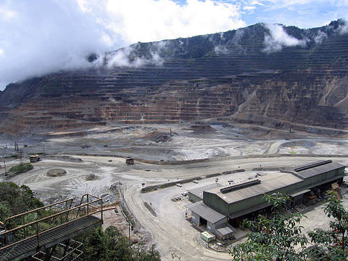
Papua New Guinea is a diverse country that still has many mysteries to be revealed in its little-explored interior. The country’s large physical area provides greater opportunities for the exploitation of natural resources for economic gain. The interior of the island has large areas that have not been exploited by large-scale development projects. In the past few decades, oil was discovered and makes up its largest export item. Gold, copper, silver, and other minerals are being extracted in extensive mining operations, often by outside multinational corporations. Subsistence agriculture is the main economic activity of most of the people. Coffee and cocoa are examples of agricultural exports.
::巴布亚新几内亚是一个多样化的国家,在很少探索的内地仍有许多秘密有待揭露,该国面积辽阔的自然区为开采自然资源以谋取经济利益提供了更大的机会,岛屿内地有大片没有被大规模发展项目开发的地区,在过去几十年中,石油被发现并构成其最大的出口项目,黄金、铜、银和其他矿物正在广泛的采矿作业中开采,往往由外部跨国公司开采,自给农业是大多数人的主要经济活动,咖啡和可可是农业出口的例子。The Ok Tedi Mine is an open-pit copper and gold mine in Papua New Guinea.
::Ok Tedi矿是巴布亚新几内亚的一个露天铜矿和金矿。
A number of islands off Papua New Guinea’s eastern coast—including Bougainville—have valuable mineral deposits. Bougainville and the islands under its jurisdiction are physically a part of the Solomon Island archipelago but are politically an autonomous region of Papua New Guinea. Volcanic vents deep under the sea continue to bring hot magma and minerals to the surface of the ocean floor, creating valuable resources. Papua New Guinea has laid claim to these islands and the underwater resources within their maritime boundaries. Rebel movements have pushed for the independence of the Autonomous Region of Bougainville but have been unsuccessful. The islands remain under the government of Papua New Guinea.
::巴布亚新几内亚东海岸外的一些岛屿,包括布干维尔,拥有宝贵的矿藏,布干维尔及其管辖下的岛屿是所罗门群岛群岛的自然组成部分,但在政治上是巴布亚新几内亚的一个自治地区,深海火山喷口继续将热岩浆和矿物带入洋底表面,创造宝贵的资源,巴布亚新几内亚对这些岛屿和水下资源在其海洋边界内提出主张,反叛运动推动布干维尔自治区独立,但没有成功,这些岛屿仍然在巴布亚新几内亚政府管辖之下。Solomon Islands
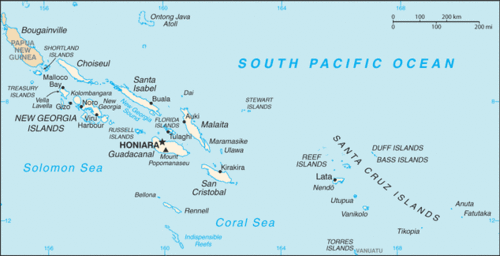
::所罗门群岛 所罗门群岛 所罗门群岛Map of the Solomon Islands
::所罗门群岛地图
To the east of the island of Guinea are the Solomon Islands, a group of more than 1,000 islands. About 80 of them hold most of the population of more than one-half of a million people. The island of Guadalcanal was the site of some of the fiercest fighting in World War II between Japan and the United States. Honiara, the capital city, is on Guadalcanal.
::几内亚岛以东是所罗门群岛,由1 000多个岛屿组成,其中约80个岛屿占人口超过150万的多数人口,瓜达尔卡纳尔岛是日本和美国二战中一些最激烈战斗的地点,首都霍尼亚拉位于瓜达尔卡纳尔岛。The Solomon Islands were a colony of Great Britain but gained independence in 1978. Colonialism, World War II, and ethnic conflict on the islands created serious centrifugal cultural forces, divisions, and political tensions over the past few decades. In 2003, military and police troops from other islands and Australia intervened to restore order after ethnic tension erupted into civil unrest.
::所罗门群岛是英国殖民地,但于1978年获得独立。 殖民主义、二战和岛上的种族冲突在过去几十年中造成了严重的离心文化力量、分裂和政治紧张。 2003年,来自其他岛屿和澳大利亚的军队和警察部队进行了干预,在种族紧张局势爆发为内乱之后恢复了秩序。Honiara is the capital city of the Solomon Islands on the northwestern coast of Guadalcanal.
::霍尼亚拉是所罗门群岛首都,位于瓜达尔卡纳尔西北海岸。
Shifting tectonic plates are the source of environmental problems. Active seismic activity has created earthquakes and tsunami conditions that have brought devastation to the region. An earthquake of 8.1 magnitude hit the Solomon Islands in 2007, bringing high waves and many aftershocks. The tsunami killed at least 52 people, and as many as 1,000 homes were destroyed. The islands contain several active and dormant volcanoes. Tropical rain forests cover a number of the islands and are home to rare orchids and other organisms. There is a concern that these resources might be harmed by deforestation and the exploitation of resources for economic gain.
::变化的构造板块是环境问题的根源。活跃的地震活动造成了地震和海啸条件,给该地区带来了破坏。2007年所罗门群岛发生了8.1级的地震,引发了巨浪和许多余震。海啸造成至少52人死亡,多达1 000所房屋被毁。岛屿上有许多活跃和休眠的火山。热带雨林覆盖许多岛屿,是稀有兰花和其他生物的栖息地。人们担心这些资源可能因砍伐森林和开采资源以谋取经济利益而受到损害。Vanuatu
::瓦努阿图 瓦努阿图Map of Vanuatu
::瓦努阿图地图
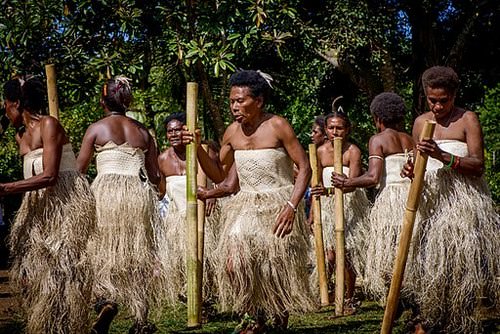
The country of Vanuatu was inhabited by a large number of South Pacific groups. As a result, many languages are spoken within a relatively small population. The French and the British both colonized the island archipelago. It was called the New Hebrides before independence in 1980 when the name was changed to Vanuatu. These small volcanic islands have an active volcano and have experienced earthquakes in recent years. One of Vanuatu’s means of bringing in business has been to establish offshore banking and financial services, similar to what is found in the Caribbean. Many shipping firms register their ships there because of the advantages of lower taxes and flexible labor laws.
::瓦努阿图居住着大量南太平洋群体,因此,许多语言在相对较少的人口中使用。法国和英国都殖民了岛屿群岛。在1980年独立前,它被称为新赫布里迪斯岛,当时名称改为瓦努阿图。这些小火山岛火山爆发活跃,近年来经历了地震。瓦努阿图的商务手段之一是建立离岸银行和金融服务,这与加勒比地区的情况相似。许多航运公司在岛上注册船舶,因为税收较低,劳动法灵活。A women's dance from Vanuatu, using bamboo stamping tubes.
::来自瓦努阿图的一支妇女舞蹈,使用竹刺管。New Caledonia
::新喀里多尼亚Map of New Caledonia
::新喀里多尼亚地图
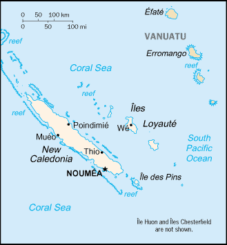
New Caledonia is still a colony of France and was once a French prison colony. Under a current agreement, sovereignty is slowly being turned over to the local island government. Periodic reevaluations of the local government will be conducted to see if independence can be granted.
::新喀里多尼亚仍然是法国的殖民地,曾经是法国的监狱殖民地,根据目前的协定,主权正慢慢地移交给当地岛屿政府,将对当地政府进行定期的重新评估,以确定能否获得独立。New Caledonia has historically relied on subsistence agriculture and fishing for its livelihood. About 25 percent of the world’s known nickel resources are located here. Nickel resources will substantially affect the economy, bring in foreign investments, and raise the standard of living.
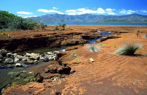
::新喀里多尼亚历史上一直依赖自给农业和渔业维持生计。 全世界已知镍资源中约有25%位于新喀里多尼亚。 镍资源将极大地影响经济,带来外国投资,提高生活水平。A creek in southern New Caledonia. Red colors reveal the richness of the ground in iron oxides and nickel.
::红色显示地上富含氧化铁和镍。Fiji
::斐济Map of Fiji
::斐济地图
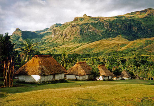
Fiji is located in the eastern sector of Melanesia and has almost one million people. The country includes more than 100 inhabitable islands, but two are home to most of the population. Colonialism heavily impacted the population’s ethnic makeup. During British colonial rule, thousands of workers from South Asia were brought in by the British to work on the sugar plantations. After a century of British rule, Fiji became independent in 1970.
::斐济位于美拉尼西亚东部地区,人口近100万,包括100多个可居住岛屿,但有两座岛屿是大部分人口的家园。 殖民主义严重影响了人口的种族构成。 在英国殖民统治期间,数千名来自南亚的工人被英国人带到甘蔗种植园工作。 经过英国统治的世纪后,斐济于1970年独立。The people of South Asian descent remained in Fiji and now make up more than one-third of the population. Ethnic conflicts erupted on the political scene between the Melanesian majority and the South Asian minority. Political coups and coalition governments have attempted to work out political solutions with limited success. Fiji is well developed and has a substantial tourism industry that increases the income of the island.
::南亚后裔人民仍然留在斐济,现在占人口的三分之一以上;美拉尼西亚多数派和南亚少数派之间在政治舞台上爆发了种族冲突;政治政变和联合政府试图以有限的成功来寻求政治解决办法;斐济发展良好,拥有庞大的旅游业,增加了该岛的收入。Several bures (one-room Fijian houses) in the village of Navala in the Nausori Highlands.
::在Nausori高地的Navala村,若干个Bures(一室斐济住房)。Micronesia
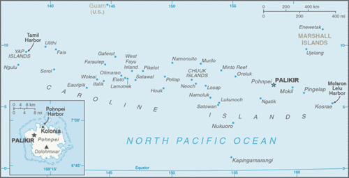
::密密密密克罗尼西亚联邦密克罗尼西亚联邦Map of Micronesia
::密克罗尼西亚地图
North of the Solomon Islands and Papua New Guinea is the large region of Micronesia. The “micro” portion of the name refers to the fact that the islands are small in size—often only one square mile or so in physical area. The region has more than 2,000 islands. Most of the islands are composed of coral and do not extend above sea level to any large extent. These low islands dominate the high islands. The high islands are usually of volcanic origin and reach elevations in the thousands of feet.
::所罗门群岛和巴布亚新几内亚的北部是密克罗尼西亚的广大地区,其名称的 " 微观 " 部分是指群岛面积小 -- -- 通常只有一平方英里左右的自然面积,该区域有2 000多个岛屿,大多数岛屿由珊瑚组成,海拔不高,这些低海拔岛屿占高岛的多数,高岛通常来自火山,高海拔数千英尺。Guam
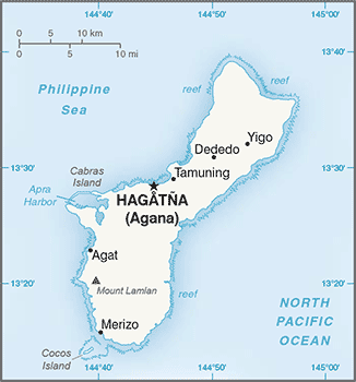
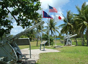
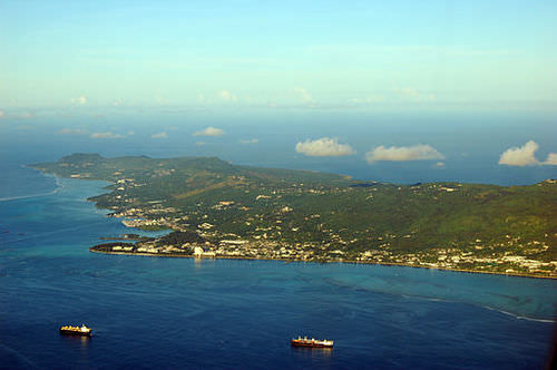
::关岛 关岛Map of Guam
::关岛地图
The largest island in Micronesia is Guam. It is only 210 square miles in area and reaches an elevation of 1,335 feet at its highest point. Coral reefs surround Guam’s volcanic center. Guam is not an independent country but a US possession. The island was a strategic location during World War II, and the United States has major military installations located on the island.
::密克罗尼西亚最大的岛屿是关岛,面积只有210平方英里,最高点达到1 335英尺。 珊瑚礁环绕着关岛火山中心。 关岛不是一个独立国家,而是一个美国拥有的岛屿。 在第二次世界大战期间,该岛是一个战略要地,美国在岛上拥有重要的军事设施。The War in the Pacific National Historical Park is a protected area in the United States territory of Guam.
::太平洋国家历史公园的战争是美国领土关岛的一个保护区。Northern Mariana Islands
::北马里亚纳群岛Map of Northern Mariana Islands
::北马里亚纳群岛地图
The Northern Mariana Islands are next to Guam and are current US possessions, along with Wake Island in the northeast. The US administers the United Nations Trust Territory of the Federated States of Micronesia. Implemented in 1986 and renewed again in 2004, the islands entered into the Compact of Free Association with the United States and established an independent status.
::北马里亚纳群岛与关岛相邻,目前是美国所有,东北还有威克岛。 美国管理着联合国密克罗尼西亚联邦托管领土。 1986年实施并于2004年再次延期,该群岛与美国签订了《自由联系条约》,并建立了独立地位。The Northern Mariana Islands, officially the Commonwealth of the Northern Mariana Islands is an insular area and commonwealth of the United States.
::北马里亚纳群岛正式成为北马里亚纳群岛联邦,是美国的一个岛屿地区和联邦。Nauru
::瑙鲁Map of Nauru
::瑙鲁地图
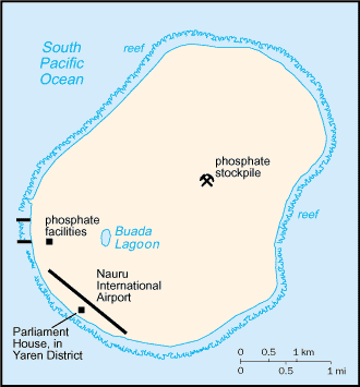
The independent island country of Nauru is only about eight square miles in physical area, but its large phosphate deposits created enormous wealth for its small population. Once the phosphates had been mined, however, there were little means to gain wealth on such a small island with a devastated landscape. Many on Nauru are trying to live off the investments from their mining wealth or have moved to find a livelihood elsewhere.
::独立的瑙鲁岛国实际面积只有约8平方英里,但其庞大的磷酸盐矿床为其小人口创造了巨大的财富。 但是,一旦磷酸盐被开采,就没有什么办法在如此面积大肆破坏的小岛屿上获得财富。 许多瑙鲁人试图靠其采矿财富的投资来维持生计,或者搬到别处谋生。Nauru has no armed forces, though there is a small police force under civilian control.
::瑙鲁没有武装部队,尽管有一支由文职人员控制的小型警察部队。
Independent Countries of Micronesia
::密克罗尼西亚独立国家-
Federated States of Micronesia
::密克罗尼西亚联邦 -
Kiribati (Western)
::基里巴斯(西) -
Marshall Islands
::马绍尔群岛 马绍尔群岛 -
Nauru
::瑙鲁 -
Palau
::帕劳 帕劳
Other Island Groups
::其他岛屿群-
Guam (US)
::关岛(美国) -
Gilbert Islands (Kiribati)
::吉尔贝群岛(基里巴斯) -
Northern Mariana Islands (US)
::北马里亚纳群岛(美国) -
Wake Island (US)
::Wake Island(美国)
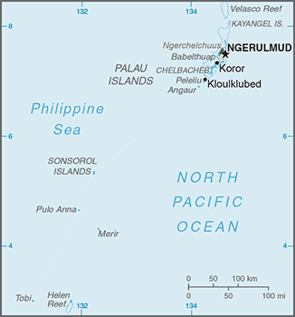
Palau
::帕劳 帕劳Map of Palau
::帕劳地图
Palau, located in western Micronesia, has a population of about 21,000 people and an area of about 177 square miles. Its early inhabitants included people from Asia and from the Pacific realm. British explorers arrived early on the island, but Spain dominated it during the colonial era. After losing the Spanish-American War, Spain sold the island to Germany, which implemented mining operations on the island.
::位于西密克罗尼西亚的帕劳人口约21 000人,面积约177平方英里,早期居民包括来自亚洲和太平洋地区的人口。 英国探险家早早抵达该岛,但西班牙在殖民时代主导该岛。 西班牙在失去西班牙-美国战争后将该岛卖给德国,德国在岛上进行采矿作业。Palauan society follows a very strict matrilineal system.
::帕劳社会遵循非常严格的母系制度。
After its defeat in World War I, Germany lost the island to Japan. Japan used it as a strategic outpost but was defeated in World War II and had to give up all its external possessions. After 1945, Palau was held by the United States and the United Nations. In 1994, the island opted for independence and retained an agreement of free association with the United States. The United States has held strategic military installations on Palau and other islands in Micronesia. Palau’s economic and geopolitical dynamics are highly reflective of US activities in the region.
::在第一次世界大战失败后,德国将该岛输给了日本。 日本将该岛作为战略前哨,但在第二次世界大战中被击败,不得不放弃所有外部财产。 1945年后,帕劳被美国和联合国占领。 1994年,该岛选择独立,并保留与美国自由结盟的协议。 美国在帕劳和密克罗尼西亚其他岛屿上拥有战略军事设施。 帕劳的经济和地缘政治动态在很大程度上反映了美国在该地区的活动。Palau's territory consists of an archipelago located in the Pacific Ocean. Its most populous islands are Angaur, Babeldaob, Koror, and Peleliu.
::帕劳领土由位于太平洋的一个群岛组成,人口最多的岛屿是安加尔岛、巴别尔达奥卜岛、科罗尔岛和佩莱利乌岛。Marshall Islands
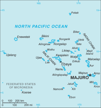
::马绍尔群岛 马绍尔群岛Map of Marshall Islands
::马绍尔群岛地图
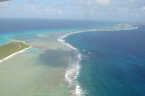
Marshall Islands , on the eastern side of Micronesia, experienced serious devastation from the conflict between Japan and the United States during World War II. The Marshall Islands became a testing ground for US nuclear weapons. Atomic bombs were tested on various atolls, rendering them uninhabitable. An atoll is a coral island that surrounds a lagoon.
::马绍尔群岛位于密克罗尼西亚东部,在第二次世界大战期间日本和美国之间的冲突中遭受了严重的破坏。 马绍尔群岛成为美国核武器的试验场。 原子炸弹在多个环礁上进行了试验,使其无法居住。 环礁是一个环礁岛,环礁环绕着一个环礁湖。The nuclear testing at Bikini Atoll program was a series of 23 nuclear devices detonated by the United States between 1946 and 1958.
::在比基尼环礁进行的核试验是1946年至1958年期间美国引爆的一系列23个核装置。
From 1946 to 1958, the United States conducted 67 atmospheric nuclear tests in the Marshall Islands. The largest was known as the Bravo test, which included the detonation of a nuclear device over Bikini Atoll that was 1,000 times more powerful than the atomic bomb dropped on Hiroshima during World War II. There are concerns about radioactive fallout that may still affect the people who inhabit nearby atolls. The Marshall Islands were granted independence in 1986 with an agreement with the United States to provide aid and protection in exchange for the use of US military bases on the islands.
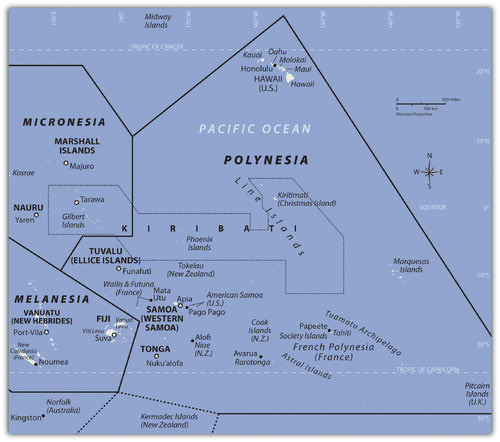
::从1946年到1958年,美国在马绍尔群岛进行了67次大气层核试验,其中最大的一次是布拉沃试验,其中包括在比基尼环礁上引爆一个核装置,比第二次世界大战期间投在广岛的原子弹威力大1 000倍。 人们担心放射性尘埃仍然可能影响居住在附近环礁的居民。马绍尔群岛于1986年获得独立,与美国达成协议,提供援助和保护,以换取美国在岛上的军事基地的使用。Polynesia
::波利尼西亚The region of Polynesia has island groups that are high islands with mountainous interiors.
::波利尼西亚地区有岛屿群,这些岛屿群是具有山区内地的高地岛屿。
The largest region of the Pacific is Polynesia, a land of many island groups with large distances between them. The root word poly means “many.” Numerous groups of islands have come together under separate political arrangements. The region includes the Hawaiian Islands in the north and the Pitcairn Islands and Easter Island to the east. New Zealand is now studied as a part of the Austral realm, but the Maori living there are originally from Polynesia.
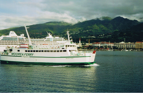
::太平洋最大的区域是波利尼西亚,这是许多岛屿群的土地,它们之间的距离很远,其根本词多指“许多”。 许多岛屿群在不同的政治安排下走到一起,包括北部的夏威夷群岛和东部的皮特凯恩群岛和复活节岛,新西兰现在作为澳斯特拉岛的一部分进行研究,但那里的毛利人最初来自波利尼西亚。Polynesia has a mixture of island types ranging from the high mountains of Hawaii, which are more than 13,800 feet, to low-lying coral atolls that are only a few feet above sea level. Islands that have enough elevation to condense moisture from the clouds receive adequate precipitation, but many islands with low elevations have a shortage of fresh water, making habitation or human development difficult.
::波利尼西亚的岛屿种类多种多样,从夏威夷高山(13 800英尺以上)到地势低的珊瑚环礁(海拔仅几英尺以上)不等。 足以从云层中凝结水分的岛屿降雨量充足,但许多低海拔岛屿缺少淡水,居住或人类发展困难重重。Polynesian culture stems from island resources. Fishing, farming, and an understanding of the seas created a way of life that gave Polynesia its identity. Polynesians created innovative maps that provided a means of sailing across large expanses of open seas to connect with distant islands. Their lifestyle revolved around natural resources and the creative use of natural materials. Polynesian art, music, and language reflect a diversity of cultural trends derived from a common heritage. The warm climate and beautiful islands contrast with violent destructive storms and a lack of fresh water or resources, which can make life difficult.
::波利尼西亚文化源于岛屿资源,渔业、农耕和对海洋的了解创造了一种使波利尼西亚具有特性的生活方式,波利尼西亚人制作了创新地图,为穿越大片公海与远方岛屿连接提供了一条通航手段,他们的生活方式围绕自然资源和创造性地使用自然材料,波利尼西亚的艺术、音乐和语言反映了源于共同遗产的各种文化趋势,温暖的气候和美丽的岛屿与暴力的破坏性风暴和淡水或资源匮乏形成对比,这可能会给生活带来困难。Independent Countries of Polynesia
::波利尼西亚独立国家-
Kiribati (eastern)
::基里巴斯(东) -
Samoa
::萨摩亚 萨摩亚 -
Tonga
::汤加 -
Tuvalu
::图瓦卢 图瓦卢
Main Island Possessions
::主要岛屿占有物-
American Samoa (US)
::美属萨摩亚(美国) -
Cook Islands (NZ)
::库克群岛(新西兰) -
Hawaiian Islands (US)
::夏威夷群岛( 美国) -
Pitcairn Islands (UK)
::皮特凯恩群岛(联合王国) -
French Polynesia (FR)
::法属波利尼西亚 -
Austral Islands
::澳洲群岛 -
The Marquesas
::马克思 -
Society Islands and Tahiti
::岛屿和塔希提社会 -
Tuamotu Islands
::图阿莫图群岛
Hawaii
::夏威夷夏威夷Island Nickname Area Population
(as of 2010)Highest point Elevation Location Hawai'i The Big Island 4,028.0 sq mi (10,432.5 km 2 ) 185,079 Mauna Kea 13,796 ft (4,205 m) 
Maui The Valley Isle 727.2 sq mi (1,883.4 km 2 ) 144,444 Haleakalā 10,023 ft (3,055 m)
O'ahu The Gathering Place 596.7 sq mi (1,545.4 km 2 ) 953,207 Mount Ka'ala 4,003 ft (1,220 m)
Kaua'i The Garden Isle 552.3 sq mi (1,430.5 km 2 ) 66,921 Kawaikini 5,243 ft (1,598 m)
Moloka'i The Friendly Isle 260.0 sq mi (673.4 km 2 ) 7,345 Kamakou 4,961 ft (1,512 m)
Lāna'i The Pineapple Isle 140.5 sq mi (363.9 km 2 ) 3,135 Lāna'ihale 3,366 ft (1,026 m)
Ni'ihau The Forbidden Isle 69.5 sq mi (180.0 km 2 ) 170 Mount Pānī'au 1,250 ft (381 m)
Kaho'olawe The Target Isle 44.6 sq mi (115.5 km 2 ) 0 Pu'u Moaulanui 1,483 ft (452 m)
At the beginning of the 21st century, Polynesia only had four independent island groups: Kiribati, Samoa, Tonga, and Tuvalu. The rest of the many islands and island groups in Polynesia are claimed by or under the control or jurisdiction of other countries: mainly the United States, France, Great Britain, or New Zealand.
::在21世纪初,波利尼西亚只有四个独立的岛屿群:基里巴斯、萨摩亚、汤加和图瓦卢,波利尼西亚其他许多岛屿和岛屿群由其他国家主张或受其他国家控制或管辖:主要是美国、法国、英国或新西兰。Hawaii was a sovereign and independent kingdom from 1810 to 1893, when the monarchy was overthrown and the islands became a republic that was annexed as a US territory. Hawaii became the 50th US state in 1959. Hawaii’s development pattern is modern, based on tourism from the continental United States and the US military base on Pearl Harbor.
::从1810年到1893年,夏威夷是一个主权和独立的王国,当时君主制被推翻,群岛成为附属于美国领土的共和国。 1959年夏威夷成为美国第50个州。 夏威夷的发展模式是现代的,以来自美国大陆的旅游业和美国珍珠港军事基地为基础。According to the , Hawaii had a population of over 1.4 million in 2017. More than one-third of the people are of Asian descent, and at least 10 percent are native Hawaiians or Pacific Islanders. The United States has a number of additional possessions in Polynesia that include various small islands, atolls, or uninhabited reefs.
::2017年夏威夷人口超过140万,其中三分之一以上是亚裔,至少10%是夏威夷原住民或太平洋岛民。 美国在波利尼西亚拥有更多财产,包括各种小岛、环礁或无人居住的珊瑚礁。The Hawaiian Islands include more islands than the few usually listed in tourist brochures. Approximately 137 islands and atolls are in the Hawaiian chain, which extends about 1,500 miles. Hawaii is one of the most remote island groups in the Pacific. The islands of the Hawaiian archipelago are a product of volcanic activity from an undersea magma source called a hotspot, which remains stationary as the tectonic plate over it continues to shift creating new volcanoes.
::夏威夷群岛包括的岛屿比旅游小册子通常列出的少数岛屿多,约有137个岛屿和环礁位于夏威夷链条上,该链条的长度约为1 500英里,夏威夷是太平洋最偏远的岛屿群之一,夏威夷群岛岛屿是海底岩浆源(称为热点)火山活动的产物,热点仍然是静止的,因为火山构造板块在不断改变,造成新的火山。Mount Kilauea, an active volcano on Hawaii, the largest island in the Hawaiian chain, is considered by geologists to be one of the most active volcanoes in the world. The active volcano of Mauna Loa and two dormant volcanoes, Mauna Kea and Hualālai, are on the same island. Mauna Kea is Hawaii’s tallest mountain at 13,796 feet above sea level, which is taller than Mount Everest if measured from its base on the ocean floor.
::夏威夷链中最大的岛屿夏威夷岛上活跃的火山Kilauea山被地质学家认为是世界上最活跃的火山之一。 活跃的Mauna Loa火山和两个休眠火山Mauna Kea和Hualālai都在同一岛上。 Mauna Kea是夏威夷海拔13,796英尺的最高山,如果从海底的底部测量的话,比珠穆朗玛峰高。Hawaii, like most islands of the Pacific realm, has a tropical type A climate, but snow can be found on the tops of its highest mountains during the winter months. The island of Kauai receives more than 460 inches of rain per year and is one of the wettest places on Earth. The rain shadow effect created by Mount Waialeale is the reason for the high level of precipitation. All the rain falls on the windward side of the mountain, creating a rain shadow on the leeward side of the mountain, which is a semi-desert.
::夏威夷与太平洋大多数岛屿一样,具有热带A型气候,但冬季几个月,在最高山峰顶部可以发现雪。考艾岛每年降雨量超过460英寸,是地球上最湿的地方之一。Waialealele山造成的雨影效应是降水量高的原因。所有雨水都落在山的风向侧,在半沙漠的山向上形成雨影。Kiribati
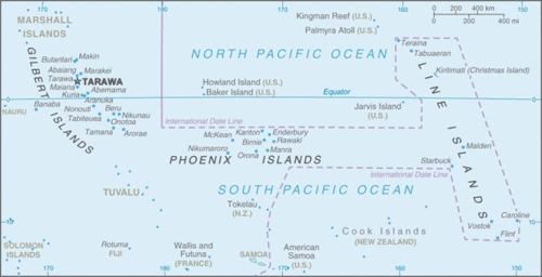
::基里巴斯Map of Kiribati
::基里巴斯地图
Kiribati includes three sets of islands located in both Micronesia and Polynesia. The main component of Kiribati is the Gilbert Island chain in Micronesia, where the capital city and most of the population are located. The other two minor island chains are the Phoenix Islands and the Line Islands in Polynesia. Both island chains were US possessions before being annexed with the Gilbert Islands to become Kiribati.
::基里巴斯包括密克罗尼西亚和波利尼西亚的三组岛屿,基里巴斯的主要组成部分是密克罗尼西亚的吉尔伯特岛链,首都和大部分人口位于密克罗尼西亚,另外两个小岛链是菲尼克斯岛和波利尼西亚的线群岛,两个岛屿链都是美国拥有的,然后与吉尔伯特群岛并吞。The Line Islands were used for testing of British hydrogen bombs starting in 1957. Three atmospheric nuclear tests were conducted by the British on Malden Island, and six were conducted on Christmas Island. There is concern about how radiation affected people present during the tests and thereafter. The Phoenix Islands have few inhabitants. In 2008, Kiribati declared the entire island group a protected environmental area, which made it the largest protected marine habitat in the world. Kiribati is the only country with land in all four hemispheres: north and south of the equator and on both sides of the 180° meridian.
::自1957年起,该群岛被用于测试英国氢弹;英国在马尔登岛进行了三次大气层核试验,在圣诞岛进行了六次核试验;人们对在试验期间及其后的辐射如何影响人们感到关切;凤凰群岛居民很少;2008年,基里巴斯宣布整个岛屿群体为受保护环境区,使其成为世界上最大的受保护海洋生境;基里巴斯是所有四个半球唯一拥有土地的国家:赤道以北和以南以及180度间距两侧。Samoa
::萨摩亚 萨摩亚
Map of Samoa
::萨摩亚地图
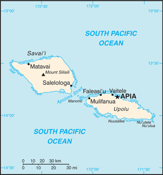
After the colonial era, Samoa was divided into Western Samoa and Eastern Samoa. The United States controlled the eastern islands, which are referred to as American Samoa. Before World War I, Germany gained control of the larger, more extensive western islands only to lose them to New Zealand after the war. Western Samoa was under the New Zealand government until 1962, when it gained independence. The name was officially changed from Western Samoa to Samoa in 1997.
::在殖民时代之后,萨摩亚被划分为西萨摩亚和东萨摩亚,美国控制了东岛屿,称为美属萨摩亚,在第一次世界大战之前,德国控制了较大的、更广阔的西岛屿,但战后又将其输给新西兰,西萨摩亚在1962年获得独立之前一直由新西兰政府统治,其名称于1997年正式从西萨摩亚改为萨摩亚。The Samoan Islands are volcanic, and the most active volcano last erupted in 1906. In Samoa, three-quarters of more than 200,000 people live on the larger of the two main islands. Colonialism has had a major impact on the culture, especially in the case of religion. Christianity became widespread once it was introduced and is now the religion of about 99 percent of the population.
::萨摩亚群岛是火山岛,是1906年最近一次爆发最活跃的火山,萨摩亚有四分之三的20多万人生活在两个主要岛屿中最大的岛屿上,殖民主义对文化产生了重大影响,特别是在宗教方面,基督教在形成后变得广泛,现在大约99%的人口信奉基督教。Samoa lies south of the equator, about halfway between Hawaii and New Zealand.
::萨摩亚位于赤道以南,距夏威夷和新西兰约一半。
American music and societal trends are also a major influence on the islands because of migration between Hawaii and the US mainland. Many Samoans have moved to the United States and established communities. Cultural traditions have been preserved and are often integrated into modern society. Samoa has some of the oldest history and traditions of Polynesia.
::由于夏威夷和美国本土之间的移徙,美国音乐和社会趋势也对群岛产生了重大影响,许多萨摩亚人移居美国和已建立的社区,文化传统得到保存,并往往融入现代社会,萨摩亚有一些波利尼西亚最古老的历史和传统。For many years, the United States has held an extensive naval station in the bay of Pago Pago on American Samoa. During World War II, there were more US military personnel on the islands than Samoans. American Samoa became a key military post for the United States. American Samoa remains a US possession. However, Samoans are not US citizens unless one of their parents is a US citizen.
::多年来,美国在美属萨摩亚的帕果帕果湾拥有一个庞大的海军基地。 在二战期间,岛上的美国军事人员比萨摩亚人多。 美属萨摩亚成为美国的一个重要军事职位。 美属萨摩亚仍然是美国的属地。 然而,萨摩亚人不是美国公民,除非父母一方是美国公民。92.6% of the population are Samoans, 7 percent Euronesians (people of mixed European and Polynesian ancestry) and 0.4 percent are Europeans, per the CIA World Factbook.
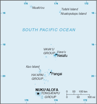
::92.6%的人口是萨摩亚人,7%是欧洲和波利尼西亚混合血统的人,0.4%是欧洲人,根据中央情报局《世界实况》。Tonga
::汤加Map of Tonga
::汤加地图
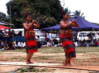
South of Samoa is an archipelago that is home to the Kingdom of Tonga. Only about 36 of the 169 islands are inhabited by a total population of about 106,000 people. Tonga is ruled by a monarchy that never lost its governance powers throughout the colonial era. Tonga is the only monarchy in the Pacific. The two main methods of gaining wealth are by remittances from citizens working abroad and tourism.
::萨摩亚南部是一个群岛,是汤加王国的家园,169个岛屿中只有大约36个岛屿的居民人口大约为106 000人,汤加由在殖民时代从未失去治理权的君主制统治,汤加是太平洋地区唯一的君主制,获得财富的两个主要方法是海外公民的汇款和旅游业。The ula (dance) is an ancient Tongan group dance, already reported by early European navigators like Captain Cook.
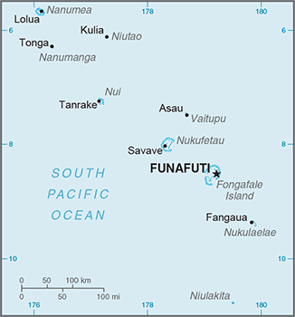
::Lula(舞)是古老的汤加团体舞蹈,Tuvalu
::图瓦卢 图瓦卢Map of Tuvalu
::图瓦卢图示图
The island nation of Tuvalu comprises four reef islands and five atolls for a total land area of about 10 square miles. In 2017, it had a population of about 11,000 people. These statistics indicate that Tuvalu is one of the four smallest countries in the world. Nauru is only about eight square miles in area. Only the Vatican and Monaco are smaller. The low elevation of the islands of Tuvalu make them susceptible to damage from rising sea levels. The highest point is only 15 feet in elevation. Any increase in ocean levels as a result of climate change could threaten the existence of this country.
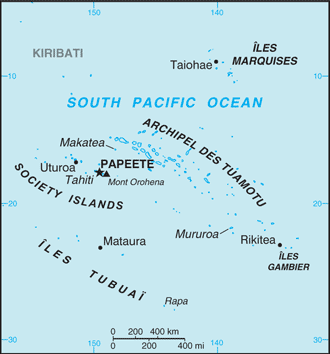
::图瓦卢岛国由4个珊瑚礁岛屿和5个环礁岛组成,总面积约为10平方英里,2017年人口约11 000人,这些数字表明图瓦卢是世界上4个最小国家之一,瑙鲁面积只有8平方英里,只有梵蒂冈和摩纳哥面积较小,图瓦卢岛屿的低海拔使其易受海平面上升的损害,最高海拔只有15英尺,气候变化导致的海平面上升可能威胁该国的生存。French Polynesia
::法属波利尼西亚Map of French Polynesia
::法属波利尼西亚地图
The South Pacific is home to many islands and island groups that are not independent countries. The biggest and most significant group in the southern region is French Polynesia. France colonized a large number of islands in the South Pacific and has continued to hold them in its control or possession as external departments or colonies.
::南太平洋是许多不是独立国家的岛屿和岛屿群的家园,南部地区最大和最重要的群体是法属波利尼西亚,法国在南太平洋殖民了大批岛屿,并继续作为外部部门或殖民地控制或拥有这些岛屿。In western Polynesia, the French maintain control over the islands of Wallis and Futuna. French Polynesia consists of four main island groups: the Society Islands, the Austral Islands, the Tuamotu Islands, and the Marquesas. There are around 130 islands in French Polynesia, and many are too small or lack resources to be inhabited.
::在西波利尼西亚,法属波利尼西亚对瓦利斯岛和富图纳岛保持控制,法属波利尼西亚由四个主要岛屿组成:社会群岛、奥斯特拉尔群岛、图阿莫图群岛和马克萨斯群岛,法属波利尼西亚约有130个岛屿,许多岛屿太小或缺乏资源,无法居住。The only ways to get to the islands are by aircraft or by ship. Transportation costs can be high for imported goods or for tourism development.
::只有飞机或船只才能到达群岛,进口货物或旅游发展运输费用可能很高。
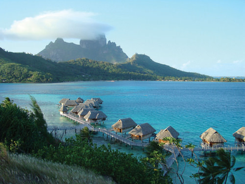
Tahiti, located in the Society Islands, is the central hub of French Polynesia. Papeete is the capital and main city with a population of almost 30,000 people. Tahiti is a major tourist destination with a mild climate that stays at 75 °F to 85 °F year-round and receives adequate rainfall to sustain tropical forests. Most of the people live along the coastal areas. The interior is almost uninhabited. The Society Islands include the island of Bora Bora, which is considered by many to be a tropical paradise and one of the most exotic tourist destinations in the world.
::位于社会群岛的塔希提岛是法属波利尼西亚的中心,帕皮提岛是首都和主要城市,人口近30 000人,塔希提岛是主要旅游目的地,气候温和,全年保持75°F至85°F,降雨量充足,以维持热带森林,大部分人居住在沿海地区,内地几乎无人居住,包括博拉博拉岛,许多人认为该岛是热带天堂,是世界上最外来的旅游目的地之一。Bora Bora is a world-class tourist destination catering to the international traveler.
::波拉博拉是一个世界级的旅游目的地,为国际游客服务。
The volcanic Marquesas Islands to the northeast are the second-most remote islands in the world after the Hawaiian Islands. The weather pattern in the Pacific does not bring enormous amounts of precipitation to the Marquesas, a reality that restricts human expansion in the archipelago. The higher elevations in the mountains—the highest is 4,035 feet—draw some precipitation from the rain shadow effect, giving rise to lush rain forests on portions of the islands.
::东北的火山马克萨斯群岛是仅次于夏威夷群岛的世界上第二偏远岛屿,太平洋的天气模式并没有给马克萨斯岛带来大量降水,而马克萨斯岛的降水量却限制了群岛内人类的扩张,山区高海拔(最高海拔为4 035英尺)从雨影效应中吸收了一些降水,导致岛屿部分地区的雨雨林泛滥。With less than 10,000 people, the Marquesas do not have a large population to support and rely on financial support from outside to sustain them. French painter Paul Gauguin is buried there, and the islands are remembered as his home during the last years of his life.
::Marquesas人不到10,000人,没有庞大的人口支持和依靠外部的财政支持来维生。 法国画家Paul Gauguin被埋葬在那里,这些岛屿在他生命的最后几年被记为他的家。The Austral Islands are the southernmost group of islands in French Polynesia and are home to only about 6,500 people. French Polynesia also includes the Tuamotu Archipelago, between the Society Islands and the Marquesas, which comprises about 75 atolls and an uncounted number of coral reefs that extend for about 900 miles. The islands have a population of fewer than 20,000 people. The main economic activity is the cultivation of black pearls and coconuts.
::大西洋群岛是法属波利尼西亚最南端的群岛,只有大约6 500人居住,法属波利尼西亚还包括社会群岛与马克萨斯群岛之间的图阿莫图群岛,该群岛由大约75个环礁和未计珊瑚礁组成,长达约900英里,群岛人口不到20 000人,主要经济活动是种植黑珍珠和椰子。The French government used islands in the Tuamotu Archipelago as test sites for nuclear weapons. From 1966 to 1974, the French tested 41 atomic devices above ground in the atmosphere, and from 1974 to 1996, they tested 137 atomic devices below ground. Radiation concerns are the same here as they are on the Marshall Islands, where the United States tested atomic weapons.
::法国政府利用图阿莫图群岛的岛屿作为核武器试验场,1966年至1974年,法国在大气层地面试验了41个原子装置,1974年至1996年,法国在地下试验了137个原子装置,这里的辐射问题与美国在马绍尔群岛试验原子武器时的辐射问题相同。Scientific testing monitored by the World Health Organization has determined the humans living closest to the atolls are not presently in danger of radioactive materials either in the environment or in their food supply. The long-term effects of underground tests continue to be monitored.
::世界卫生组织监测的科学试验确定,目前居住在环礁岛附近的人类在环境或食物供应方面没有放射性物质的危险,地下试验的长期影响继续受到监测。The Pitcairn Islands, Easter Island, and the Cook Islands
::皮特凯恩群岛、复活岛和库克群岛To the east of French Polynesia are the four Pitcairn Islands, controlled by Great Britain. The main island, Pitcairn, is the only inhabited island in this chain and is one of the least inhabited islands in the world; the total population is fewer than 50 people. Mutineers from the HMS Bounty escaped to Pitcairn in 1790 after taking various Tahitians with them.
::法属波利尼西亚以东是四个皮特凯恩群岛,由英国控制,主要岛屿皮特凯恩是这一链条中唯一有人居住的岛屿,是世界上居民最少的岛屿之一;总人口不到50人,1790年,来自英国皇家海军邦蒂的叛乱分子在带走塔希提人之后逃到皮特凯恩。Even farther east than Pitcairn, on the edge of Polynesia, is Easter Island. Now under the government of Chile, Easter Island was historically inhabited by Polynesians who built large stone heads that remain somewhat of a mystery. At the center of Polynesia are the 15 small Cook Islands, which are controlled by New Zealand and are home to about 20,000 people, many of whom claim Maori ethnicity.
::比波利尼西亚边缘的皮特凯恩更东远的地方是复活节岛,现在在智利政府统治下,复活节岛历来由波利尼西亚人居住,他们建造了巨大的石头头,这些石头头仍然有些神秘。 波利尼西亚的中心是15个库克群岛,由新西兰控制,居住着大约20,000人,其中许多人声称是毛利人。Key Takeaways
::密钥外出-
Melanesia includes the islands from Papua New Guinea to Fiji. Micronesia includes small islands located north of Melanesia. Polynesia includes island groups from the Hawaiian Islands to the Pitcairn Islands. Papua New Guinea is the largest country in the Pacific, approximately seven hundred languages are spoken by the many local groups that live there.
::美拉尼西亚包括从巴布亚新几内亚到斐济的岛屿,密克罗尼西亚包括位于美拉尼西亚以北的小岛屿,波利尼西亚包括从夏威夷群岛到皮特凯恩群岛的岛屿群,巴布亚新几内亚是太平洋最大的国家,居住在那里的许多当地群体使用约700种语言。 -
Low islands in this region are usually composed of coral and low in elevation. High islands are usually volcanic in origin and mountainous with high elevations. Micronesia consists mainly of low islands, while Polynesia consists of many high islands, such as Hawaii.
::该区域低海拔岛屿通常由珊瑚组成,高海拔低,高海拔岛屿通常由火山和高山组成,密克罗尼西亚主要由低海拔岛屿组成,波利尼西亚由夏威夷等许多高海拔岛屿组成。 -
Tourism is the main economic activity in the Pacific, but minerals and fossil fuels provide some islands with additional wealth. Fishing and subsistence agriculture have been the traditional livelihoods. Offshore banking has also been established in the region.
::旅游业是太平洋的主要经济活动,但矿物和化石燃料为一些岛屿提供了更多的财富,渔业和自给农业一直是传统生计,在该区域也建立了境外银行业务。 -
The United States, the United Kingdom, and France used various islands for nuclear testing. Radiation fallout continues to be an environmental concern. Typhoons, tsunamis, volcanic activity, earthquakes, and flooding create devastation on the islands. Fresh water can be a valuable resource, as it is in short supply on many islands.
::美国、英国和法国利用各个岛屿进行核试验。 辐射沉降仍然是一个环境问题。 台风、海啸、火山活动、地震和洪水给这些岛屿造成了破坏。 淡水可以成为宝贵的资源,因为许多岛屿的淡水供应不足。
Vocabulary Terms
::词汇术语术语Chapter 11.4 The Pacific Islands
::第11.4章 太平洋岛屿archipelago
::群岛A series of groups of island chains
::一系列岛屿连锁链atoll
::环环礁A ring-like coral island or string of small islands surrounding a lagoon
::环环环环珊瑚岛或环环环环环环环环环环环环环环环环环环环环环环环环环环环环环环环环环环环环环环环环环环环环环环环环环环环环环环珊瑚岛或环环环环环环环环环环环环环环环环环环环环环环环环环环环环环环环环环环环环环环环环环环环环环环环环环环环环环环环环环环环环环环环环环环环环环环环环环环环环环环环环环环环环环环环环环环环环环环环环环环环环珊瑚岛或环环环环环环环环环环环环环环环环环环环环环环环环环环环环环环环环环环环环环环环环环环环环环环环环环环环环环环环环环环环环环环环环环环环环环环环环环环环环环环环环环环环环环环环环环环环环环环环环环环环环环环环环环环环环环环环环环环环环环环环环环环环环环环环环环环环环环环环环环环环环环环环环环环环环环环环环环环环环环环环环环环环环环环环环环环环环环环环环环环环环环环环环环环环环环环环环环环环环环环环环环环环环环环环环环环环环环环环环环环环环环环环环环环环环环环环环环环环环环环环环环环环环环环环环环环环环环环环环环环环环环环环环环环环环环环环环环环环环环环环环环环环环环环环环环环环环环环环环环环环环环环环环环环环环环环环环环环环环环环环环环环环环环环环环环环环环环环环环环环环环环环Bikini Atoll
::比基尼环礁The isolated reef, located in the Marshall Islands of the Central Pacific, that was the site of US nuclear bomb tests, consequently contaminating the atoll with high levels or radiation and riving its inhabitants away
::位于中太平洋马绍尔群岛的孤立珊瑚礁是美国进行核炸弹试验的场所,因此以高水平或辐射污染环礁,使岛上居民流离Guadalcanal
::瓜达尔卡纳尔语NamePrincipal island in the Solomon Islands that was the sight of vicious fighting between the American's and Japanese during WWII
::所罗门群岛的主要岛屿是第二次世界大战期间美日之间恶毒战斗的景象high islands
::高海岛these islands are generally young, homogenous, multiple (altitudinal) environmental zones. Poor in some resources (rock). Many have wet (windward) and dry (leeward) sides with distinct environments
::这些岛屿一般都是年轻、同质、多重(态度)环境区,有些资源贫乏(岩石),许多有湿(向风)和干(向风)两边,环境不同。Liliuokalani
::利里乌卡兰尼The queen and last sovereign ruler of Hawaii until it was annexed by the United States
::夏威夷女王和最后一位主权统治者 直到被美国吞并low islands
::低岛屿Pacific islands made out of coral reefs
::由珊瑚礁构成的太平洋岛屿Melanesia
::美美拉尼西亚A region in Oceania means "black island"
::大洋洲的一个区域意指“黑岛”Micronesia
::密密密密克罗尼西亚联邦密克罗尼西亚联邦One of three regions in Oceania, meaning "tiny islands"
::大洋洲三个区域之一,意思是“九岛”Oceania
::大洋洲The group of islands in the Pacific, including Melanesia, Micronesia, and Polynesia
::太平洋群岛群,包括美拉尼西亚、密克罗尼西亚和波利尼西亚ozone depletion
::臭氧消耗潜能值The wearing out or reduction of the earth's Ozone or Stratosphere
::地球臭氧或平流层的损耗或减少Polynesia
::波利尼西亚Islands of the central and southern Pacific
::中太平洋和南太平洋群岛Applying Knowledge
::应用知识Interactive Notebook Activities
::互动笔记活动-
List
the three main areas of the South Pacific.
::列出南太平洋的三个主要地区。 -
Explain
the difference between low islands and high islands.
::解释低岛和高岛之间的区别。 -
List
which islands remain under the control of France, the United Kingdom, New Zealand, or the United States.
::法国、联合王国、新西兰或美国仍然控制着哪些岛屿的清单。 -
Describe
the primary economic activities of the islands in the realm.
::描述群岛在本领域的主要经济活动。 -
Summarize
the main environmental concerns of the islands in each region.
::概述了每个区域岛屿的主要环境问题。
Discussion and Study Questions
::讨论和研究问题-
What are the three main regions of islands in the Pacific? What island nations belong to each?
::太平洋岛屿的三个主要区域是什么?每个岛屿的国家属于哪个岛屿国家? -
What are the traditional methods of making a living on the Pacific islands?
::在太平洋岛屿上谋生的传统方法是什么? -
What is the difference between a low island and a high island? Give examples of each.
::低岛与高岛之间有什么区别?请举例说明。 -
Why are so many islands in the Pacific governed by the United States?
::为什么太平洋地区有这么多岛屿由美国管理? -
Name three major environmental concerns of these islands.
::列出这些岛屿的三个主要环境问题。 -
What has been a growing sector of the economy for many of the Pacific islands?
::对于许多太平洋岛屿来说,什么是日益增长的经济部门? -
Which island group is the largest protected environmental marine habitat in the world?
::哪个岛屿组是世界上最大的受保护的海洋环境生境? -
What islands did the United States, Great Britain, and France use for testing nuclear weapons?
::美国、英国和法国用哪些岛屿来试验核武器? -
On which island are more than seven hundred separate languages spoken? Why are so many languages spoken?
::在哪个岛上有七百多种不同的语言? 为什么讲这么多语言? -
What main factors have determined the economic activities of the Pacific?
::哪些主要因素决定了太平洋的经济活动?
Real-World Geography Exercise
::现实世界地理演习-
Using
, complete the following activities:
-
Locate each place on the bulleted list below.
::在下面的子弹名单上 找到每个地方 -
Find the nearest city with an international airport in proximity to each location on the bulleted list below.
::找到最近的城市,在下面子弹清单上每个地点附近有一个国际机场。 -
Calculate the distance and travel time by plane to each city from the
in Honolulu, Hawaii.
::计算从夏威夷火奴鲁鲁 飞往每个城市的飞机 距离和旅行时间
::使用,完成以下活动: 确定以下子弹子弹清单上的每个地点; 找到最近的城市, 附近有一个国际机场, 在下面子弹清单上的每个地点。 计算从夏威夷火奴鲁鲁到每个城市的飞机距离和飞行时间。 -
Locate each place on the bulleted list below.
-
Using
, determine the latitude and longitude for each location on the bulleted list below.
::使用,确定以下子弹列表中每个位置的纬度和经度。 -
Be prepared to share and discuss your answers.
::准备分享和讨论你的答案
-
American Samoa
::美属萨摩亚 -
Austral Islands
::澳洲群岛 -
Bora Bora
::波拉博拉 -
Cook Islands
::库克群岛库克群岛 库克群岛 -
Easter Island
::复活岛岛 -
Fiji
::斐济 -
French Polynesia
::法属波利尼西亚 -
Gilbert Islands
::吉尔贝群岛 -
Guadalcanal
::瓜达尔卡纳尔语Name -
Guam
::关岛 关岛 -
Hawaiian Islands
::夏威夷群岛 -
Kiribati
::基里巴斯 -
Marquesas
::荣誉 -
Marshall Islands
::马绍尔群岛 马绍尔群岛 -
Melanesia
::美美拉尼西亚 -
Micronesia
::密密密密克罗尼西亚联邦密克罗尼西亚联邦 -
Nauru
::瑙鲁 -
Northern Mariana Islands
::北马里亚纳群岛 -
Palau
::帕劳 帕劳 -
Papua New Guinea
::巴布亚新几内亚 巴布亚新几内亚 -
Pitcairn Islands
::皮特凯恩 -
Polynesia
::波利尼西亚 -
Samoa
::萨摩亚 萨摩亚 -
Society Islands
::岛屿社会学会 -
Solomon Islands
::所罗门群岛 所罗门群岛 所罗门群岛 -
Tahiti
::塔希提 -
Tonga
::汤加 -
Tuamotu Islands
::图阿莫图群岛 -
Tuvalu
::图瓦卢 图瓦卢 -
Vanuatu
::瓦努阿图 瓦努阿图 -
Wake Island
::休克岛 -
Western Samoa
::西萨摩亚
Current Events
::当前事件Videos for Geography Enrichment
::地理丰富视频Helpful Websites for the Study of Geography
::地理研究有用网站is an encyclopedia funded by the Canadian government covering all branches of knowledge. Their scholarly collection includes interactive materials.
::该百科全书由加拿大政府资助,涵盖所有知识分支,其学术收藏包括交互式材料。provides information on the people, history, government, economy, energy, geography, communications, transportation, military, and transnational issues for the world's entities.
::向世界各实体提供关于人民、历史、政府、经济、能源、地理、通信、运输、军事和跨国问题的资料。is a US government website where you can find federal legislation, past and present, as well as information about the US legal system.
::是一个美国政府的网站,您可以在此找到过去和现在的联邦立法以及关于美国法律制度的信息。is a government agency website that provides current news, resources, topics of interest, information about drugs, careers in the DEA, and a tip hotline.
::是一个政府机构网站,提供最新消息、资源、感兴趣的话题、毒品信息、在缉毒局的职业以及一条小费热线。is the largest library in the world and provides manuscripts, files, information, pictures, and videos.
::图书馆是世界上最大的图书馆,提供手稿、文件、信息、图片和录像。is a US government agency website that allows users to search for and retrieve satellite images of Earth.
::这是一个美国政府机构的网站,用户可以搜索和检索地球的卫星图像。is a US government website that provides historical documents, photos, records, publications, and educator resources.
::这是一个美国政府网站,提供历史文件、照片、记录、出版物和教育资源。is a US government agency website that provides weather-related information and ocean research.
::是一个提供气象信息和海洋研究的美国政府机构网站。is a website by the United States Geological Survey and other federal, state, and local agencies that delivers topographic information for the United States.
::这是美国地质调查局和其他联邦、州和地方机构为美国提供地形信息的网站。is a massive central data source and a handy way to graphically compare nations.
::是一个庞大的中央数据源,是用图形比较国家的一种方便方式。is a website that measures most locations in the world for air pollution in real time.
::是一个实时测量世界上大多数空气污染地点的网站。is a unique statistical database which allows you to research and compare a multitude of different data on US states.
::这是一个独特的统计数据库, 使你能够研究和比较关于美国各州的多种不同数据。is an international organization founded in 1945 and made up of 193 member states. The UN maintains international peace and security, protects human rights, delivers humanitarian aid, promotes sustainable development, and upholds international law.
::联合国是一个国际组织,成立于1945年,由193个成员国组成。 联合国维护国际和平与安全,保护人权,提供人道主义援助,促进可持续发展,维护国际法。is a US government agency that provides a population clock, data, surveys, statistics, a library with information and infographics, news about the economy, and much more.
::这是一个美国政府机构,它提供人口钟、数据、调查、统计、一个拥有信息和信息资料的图书馆、关于经济的新闻,以及更多。is a US government agency website that provides scientific information about the natural hazards that threaten lives, the natural resources we rely on, the health of our ecosystems and environment, and the impacts of climate and land-use change.
::这是一个美国政府机构的网站,提供科学信息,说明威胁生命的自然危害、我们赖以生存的自然资源、生态系统和环境的健康以及气候和土地使用变化的影响。is a US government website that provides the latest presidential news, information about the budget, policy, defense, and many more topics.
::提供最新总统新闻、预算、政策、国防等资讯, 以及更多议题。is under the United Nations and provides leadership on matters critical to health, shapes the research agenda on health, and monitors the health situation and assessing health trends around the world. Their website provides information on the state of health around the world, outbreaks, current health news, and more.
::网站提供世界各地卫生状况、疫情爆发、最新卫生新闻等信息。is an intergovernmental organization that regulates international trade. The website provides information on the history of the multilateral trading system, featured videos, news and events, trade topics, and more.
::该网站提供关于多边贸易体系历史的信息、视频、新闻和事件、贸易专题等等。 -
List the three main areas of the South Pacific.