5.4海底扩张的测深证据
章节大纲
-
How can war further science?
::战争怎么能推进科学呢?Oddly, the thing that was needed to further Wegener's idea was World War II. U.S. Navy ships cruised the seas. They carried instruments that helped scientists to locate the mechanism for moving continents.
::奇怪的是,为了进一步推进韦格纳的想法,需要的东西是二战,美国海军舰船巡洋航行。它们携带仪器帮助科学家找到移动大陆的机制。Echo Sounders
::E回音探测器During World War II, battleships and submarines carried echo sounders. Their goal was to locate enemy submarines ( Figure ). Echo sounders produce sound waves that travel outward in all directions. The sound waves bounce off the nearest object and then return to the ship. Scientists know the speed of sound in seawater. They then can calculate the distance to the object that the sound wave hit. Most of these sound waves did not hit submarines. They instead were used to the ocean floor.
::二战期间,战舰和潜艇载运回声探测器,目的是定位敌潜艇(图)。回声探测器产生声波,向外波向外移动。声波从最近的物体中弹出,然后返回船上。科学家知道海水中声音的速度。然后他们可以计算声波撞击物体的距离。这些声波大多没有击中潜艇,而是习惯在洋底。A ship sends out sound waves to create a picture of the seafloor below it. The echo sounder pictured has many beams, and, as a result, it creates a three dimensional map of the seafloor beneath the ship. Early echo sounders had only a single beam and created a line of depth measurements. Seafloor Features
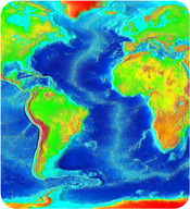
::海底地物Scientists expected the to be flat and featureless. So they were shocked by what they saw: tremendous topographical features like mountain ranges, rifts, and trenches . Oceanographic research vessels continue to map the seafloor as they sail across the seas today. The map below is a modern map with data from several decades.
::科学家们预计海平面将是平坦的、无特色的。因此,他们对所看到的巨大的地形特征,如山脉、裂谷和海沟感到震惊。 海洋学研究船继续绘制海平面的地图,因为它们在今天的海上航行。 下面的地图是一张现代地图,有数十年的数据。The major features of the ocean basins and their colors on the map include:
::地图上海洋盆地的主要特征及其颜色包括:- mid-ocean ridges : A long chain of mountains that rises up high above the deep seafloor. An example is the light blue gash in middle of Atlantic Ocean. Light blue is higher than dark blue.
::中洋洋脊:一长串高在深海海底之上的山脉,例如大西洋中部的浅蓝色气道,浅蓝色高于深蓝色。
- rift zones: In the middle of the mid-ocean ridges is a rift zone. The rift cuts the ridge into pieces. It is lower in elevation than the mountains of the mid-ocean ridge .
::裂缝区:在洋中脊中间有一个裂缝区。裂缝将脊切成碎片。海拔低于洋中脊的山峰。
- deep sea trenches : Trenches are found in the sea. Some are near the edges of continents. Trenches are found near chains of active volcanoes . An example is the line of the very deepest blue, off of western South America.
::深海战壕:海中发现了战壕,有些在大陆边缘。在活火山链附近发现了战壕。南美洲西部最深的蓝色线就是一个例子。
- abyssal plains : Flat areas that may be dotted with volcanic mountains. An example is the consistent blue off of southeastern South America.
::深海平原: 可能与火山山脉相撞的平坦地区。 南美洲东南部的连续蓝色就是一个例子。
- guyots : Flat-topped mountains that appear to have been eroded yet are thousands of feet below sea level .
::平坦的山峰似乎已被侵蚀, 却在海平面以下数千英尺处。
- : The transition from the land to the sea. The continental margin is made of continental crust which happens to be below sea level. More than one-quarter of the ocean basin is continental margin. An example is the light blue area around the edges of each continent .
::大陆边由大陆地壳构成,地壳恰好低于海平面,超过四分之一的海洋盆地是大陆边,每个大陆边缘周围的浅蓝色区域就是一个例子。
See if you can identify each of these features on the map (( Figure )) below.
::看看能否在地图(图())上标明其中的每一个特征。A modern map of the southeastern Pacific and Atlantic Oceans. The first scientists to observe these features wondered how they had formed. It turns out that they were crucial for fitting together ideas about seafloor spreading , which would in turn prove to be the mechanism for continental drift.
::第一批观察这些特征的科学家想知道这些特征是如何形成的。 事实证明,这些特征对于整合关于海底扩散的构想至关重要,而这反过来又证明是大陆漂移的机制。Summary
::摘要- Echo sounders were used to search for enemy submarines during World War II. The depths they recorded allowed scientists to piece together bathymetric maps of the seafloor. Multi-beam sounders work on research vessels today.
::在二战期间,对敌潜艇进行了回声探测。它们记录的深度使科学家能够绘制海底测深图。今天,多波束探测仪在研究船上工作。
- These maps revealed amazing features like mid-ocean ridges, deep-sea trenches, and abyssal plains.
::这些地图揭示了洋中脊、深海海沟和深海平原等惊人的特征。
- The features of the seafloor helped scientists to discover the mechanism for continental drift.
::海底的特征有助于科学家发现大陆漂移机制。
Review
::回顾- How does an echo sounder create a bathymetric map?
::一个回声声音仪如何绘制测深图?
- What are the features of the seafloor that are elevated?
::升高的海底的特征是什么?
- What are the features of the seafloor that are very deep?
::海底深层的特征是什么?
Explore More
::探索更多Use the resource below to answer the questions that follow.
::利用以下资源回答以下问题。- What did Harry Hess use his sonar for?
::哈利·赫斯用声纳做什么?
- What did Hess discover?
::赫斯发现了什么?
- What was discovered in 1953?
::1953年发现了什么?
- What did Hess discover was occurring at the ridge?
::赫斯在山脊发现了什么?
- What did Hess call his discovery?
::赫斯说他的发现是什么?
- What process recycles the crust?
::什么过程可以回收地壳?
- mid-ocean ridges : A long chain of mountains that rises up high above the deep seafloor. An example is the light blue gash in middle of Atlantic Ocean. Light blue is higher than dark blue.