非洲:介绍王国(1天)
章节大纲
-
Chapter Challenges
::章次 挑战-
Summarize the basic geography of Sub-Saharan Africa.
::概述撒哈拉以南非洲的基本地理情况。 -
Identify the African Transition Zone, including the transitions that are occurring in the zone. Locate the main features on a map.
::确定非洲过渡区,包括该区正在发生的过渡,在地图上标出主要特征。 -
Understand how early kingdoms flourished in Sub-Saharan Africa before the colonial era. Identify how selective groups in these kingdoms participated in the supply operations for the slave trade.
::了解在殖民时代之前,撒哈拉沙漠以南的非洲王国是如何繁荣的。 确定这些王国的选择性团体如何参与奴隶贸易的供应活动。 -
Explain how European colonialism divided up Africa and the role the Berlin Conference played in the colonization process in Africa.
::解释欧洲殖民主义如何分裂非洲以及柏林会议在非洲殖民化进程中发挥的作用。 -
Outline how countries have transitioned from colonies to independent nations, including the many issues involved in this transition.
::概述各国如何从殖民地向独立国家过渡,包括这一过渡涉及的许多问题。
Student Learning Objectives
::学生学习目标TEKS Regional Unit 08 Africa; Chapter 8.1 Introducing the Realm
::TEKS 区域股 08 非洲;第8.1章 介绍王国WG.2A Describe the human and physical characteristics of the same regions at different periods of time to evaluate relationships between past events and current conditions.
::WG.2A 描述不同时期同一区域的人的和自然的特征,以评估过去事件与当前状况之间的关系。WG.4C Explain the influence of climate on the distribution of biomes in different regions.
::WG.4C 解释气候对不同区域生物群落分布的影响。WG.5A Analyze how the character of a place is related to its political, economic, social, and cultural elements.
::WG.5A 分析一个地方的特性如何与其政治、经济、社会和文化因素相关。WG.11B Identify the factors affecting the location of different types of economic activities, including subsistence and commercial agriculture, manufacturing, and service industries.
::WG.11B 查明影响不同类型经济活动地点的因素,包括生计和商业农业、制造业和服务业。WG.13A Interpret maps to explain the division of land, including man-made and natural borders, into separate political units such as cities, states, or countries.
::WG.13A 解释地图,解释土地划分,包括人造边界和自然边界,分为不同的政治单位,如城市、州或国家。WG.13B Compare maps of voting patterns or political boundaries to make inferences about the distribution of political power.
::WG.13B 比较投票模式或政治边界地图,以推断政治权力的分配。WG.14A Analyze current events to infer the physical and human processes that lead to the formation of boundaries and other political divisions.
::WG.14A 分析当前事件,以推断导致形成边界和其他政治分裂的物质和人类过程。WG.16D Compare life in a variety of urban and rural areas in the world to evaluate political, economic, social, and environmental changes.
::WG.16D 比较世界不同城市和农村地区的生活,以评价政治、经济、社会和环境变化。WG.17A Describe and compare patterns of culture such as language, religion, land use, education, and customs that make specific regions of the world distinctive.
::WG.17A 描述和比较使世界特定区域具有独特性的语言、宗教、土地使用、教育和习俗等文化模式。WG.17B Describe major world religions, including Animism, Buddhism, Christianity, Hinduism, Islam, Judaism, and Sikhism, and their spatial distribution.
::WG.17B 描述世界主要宗教,包括Animis、佛教、基督教、印度教、伊斯兰教、犹太教和锡克教及其空间分布。WG.18A Analyze cultural changes in specific regions caused by migration, war, trade, innovations, and diffusion.
::WG.18A 分析移徙、战争、贸易、创新和传播在特定区域造成的文化变化。WG.18B Assess causes, effects, and perceptions of conflicts between groups of people, including modern genocides and terrorism.
::WG.18B 评估各群体之间冲突的原因、影响和看法,包括现代种族灭绝和恐怖主义。WG.18C Identify examples of cultures that maintain traditional ways, including traditional economies.
::WG.18C 查明保持传统方式的文化实例,包括传统经济。WG.21A Analyze and evaluate the validity and utility of multiple sources of geographic information such as primary and secondary sources, aerial photographs, and maps.
::WG.21A 分析和评价多种地理资料来源,例如主要和次要资料来源、航空照片和地图的有效性和效用。WG.21B Locate places of contemporary geopolitical significance on a map.
::WG.21B 在地图上标出具有当代地缘政治意义的地点。WG.22A Design and draw appropriate graphics such as maps, diagrams, tables, and graphs to communicate geographic features, distributions, and relationships.
::WG.22A 设计和绘制适当的图形,如地图、图表、表格和图表,以交流地理特征、分布和关系。WG.22C Use geographic terminology correctly.
::WG.22C 正确使用地理术语。Africa: Introducing the Realm
::非洲:介绍王国There is a lot of variation in how the regions of Sub-Saharan Africa are identified on maps. The debate is not about what regions are in Sub-Saharan Africa but rather about which countries are to be included within each region. The regions have both similarities and differences. The cultural geography varies widely from country to country and from one ethnic group to another. There are also shared cultural patterns across all Sub-Saharan African regions. For example, colonialism has been a major historical factor in the shaping of the countries. Families are large, and the rapid rural-to-urban shift is occurring in all regions. Every region has large urban centers. They are often port cities that act as central core locations supported by a large peripheral rural hinterland.
::如何在地图上确定撒哈拉以南非洲地区差别很大,辩论的焦点不是哪些地区在撒哈拉以南非洲,而是哪些国家将被纳入每个区域,各区域有相似之处和差异,文化地理因国而异,各族裔群体各有差异,撒哈拉以南非洲各地区都有共同的文化模式,例如,殖民主义是国家形成的一个主要历史因素,家庭规模很大,各个区域都出现了农村向城市的迅速转变,每个区域都有较大的城市中心,它们往往是港口城市,作为中心核心地点,得到周边大型农村内地的支持。Globalization has entered into the dynamics connecting these once-remote regions with the rest of the world. Advancements in communication and transportation technology have created networks connecting Africa with global markets. Sub-saharan Africa has a young population seeking to gain from opportunities or advantages. The political arena is dynamic because of changes in political leadership through coups or military takeovers.
::全球化已经进入了将这些一度遥远的区域与世界其他地区连接起来的动态;通信和运输技术的进步创造了将非洲与全球市场连接起来的网络;亚萨哈拉非洲有年轻人口寻求机会或优势;政治舞台由于政变或军事接管导致政治领导权发生变化而充满活力。Sub-Saharan Africa is home to some of the poorest countries in the world. Poverty is evident in the countryside and in the urban slums of the largest cities. Bitter civil wars are a part of every region’s history. Violence and conflicts continue in some areas, while other areas exhibit political stability and thriving economies. The diversity in human geography is the most noteworthy dynamic in Sub-Saharan Africa. The variety of ethnic groups along with many languages and religions create strong centripetal and centrifugal forces.
::撒哈拉以南非洲是世界上一些最贫穷国家的家园,贫困在农村和大城市的城市贫民窟中十分明显。 贫困是每个地区历史的一部分。 恶性内战是每个地区历史的一部分。 暴力与冲突在一些地区继续发生,而其他地区则呈现政治稳定和繁荣的经济。 人类地理的多样性是撒哈拉以南非洲最值得注意的动态。 种族群体的多样性以及许多语言和宗教创造了强大的百科和离心力量。Most of the population live an agrarian lifestyle. However, there are people who are developing the skills necessary to adapt to the rapid globalization that is importing new technology and new ideas to the continent. The urban core areas of the continent are the main focus of global trends in technology and communication. These urban core areas exhibit the dynamics of the core-periphery spatial relationship. Sub-Saharan Africa has many core areas and many peripheral areas. The core urban centers have political power because of the social elites who have connections to the global economy.
::大部分人口都以农业为生活方式,但是,有一些人正在发展必要的技能,以适应正在非洲大陆引进新技术和新思想的迅速全球化。非洲大陆的城市核心地区是全球技术和通信趋势的主要焦点。这些城市核心地区显示了核心周边空间关系的动态。撒哈拉以南非洲有许多核心地区和许多外围地区。核心城市中心具有政治权力,因为社会精英与全球经济有联系。
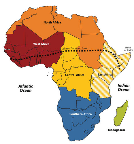
Africa is divided into regions along traditional boundaries.
::非洲按传统边界划分为区域。
These core urban areas attract people with large families from rural peripheral areas seeking employment. Millions of people in Africa who seek employment migrate to the cities or even other countries to find work. These immigrants are often not of the same ethnic group as those in power. Because of the inequalities, immigrants are at a disadvantage because of governmental discriminatory policies.
::这些核心城市地区吸引了来自农村外围地区的大家庭寻求就业的人,在非洲,数以百万计寻求就业的人移徙到城市,甚至其他国家寻找工作,这些移民往往与当权者不同,由于不平等,移民由于政府歧视性政策而处于不利地位。These dynamics can fuel protest activities with a goal of overthrowing the powerful elite. Various ideas have been proposed to help the move towards equality. One of the most favored options is the implementation of a democratic government, where citizens have a vote.
::这些动态可以刺激抗议活动,目的是推翻强权精英。 已经提出了各种想法来帮助向平等迈进。 最有利的选择之一是建立一个民主政府,公民在其中拥有投票权。Patterns and dynamics of people and places are repeated throughout the Sub-Saharan realm. The regions share common demographic trends of large family sizes, agrarian lifestyles, and low-income levels. The patterns of an economy based on agricultural production and mineral extraction as well as disruptive changes in political leadership are common. Each region has diverse ethnic groups and many different languages.
::整个撒哈拉以南地区都重复了人口和地点的格局和动态,各地区有着家庭规模大、农业生活方式和低收入水平的共同人口趋势,农业生产和矿物开采的经济模式以及政治领导层的破坏性变化是常见的,每个地区都有不同的种族群体和多种不同的语言。Christianity and Animism are the most common religions practiced south of the African Transition Zone. Whereas, Islam is widespread north of the zone. Division and civil unrest occur frequently because of the different belief systems struggling for political power. The culture of Sub-Saharan Africa is vast and complex.
::基督教和Animism是非洲过渡区以南最常见的宗教,而伊斯兰则在过渡区以北蔓延,分裂和内乱经常发生,因为不同的信仰体系为争取政治权力而斗争,撒哈拉以南非洲的文化是广阔而复杂的。Physical Geography of Sub-Saharan Africa
::撒哈拉以南非洲自然地理The African Transition Zone divides North Africa from the rest of Africa because of climatic and cultural dynamics. Dry, arid type B climates, common in the Sahara Desert, are dominant north of the zone. Tropical type A climates prevail south of the zone. Global climate changes continue to shape the continent.
::非洲过渡区由于气候和文化动态,将北非与非洲其他地区分隔开来,撒哈拉沙漠中常见的干旱的B型气候以该区以北,热带A型气候以该区以南,全球气候变化继续影响着该大陆。The shifting sands of the Sahara are slowly moving southward toward the tropics. Desertification in the zone continues as natural conditions and human activity place pressure on the region through overgrazing and the lack of precipitation. Type B climates resurface again south of the tropics in the southern latitudes. The Kalahari and Namib Deserts are located in Southern Africa, mainly in the countries of Botswana and Namibia.
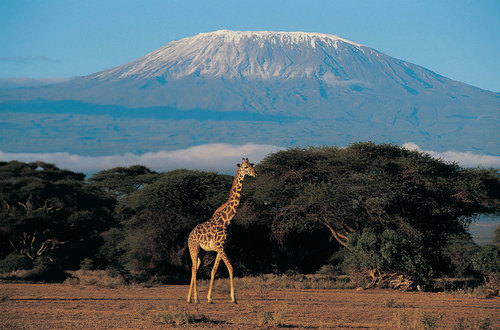
::撒哈拉的变沙正在向南向热带缓慢移动,该地区的荒漠化在继续,因为自然条件和人类活动通过过度放牧和降水不足对该地区造成压力,B型气候在南部纬度热带以南再次出现,卡拉哈里和纳米布沙漠位于南部非洲,主要位于博茨瓦纳和纳米比亚两国。For a continent as large as Africa, Sub-Saharan Africa does not have extended mountain ranges comparable to the ranges in North America, South America, Europe, Asia, or the Antarctica. However, on the , the Ethiopian Plateau has an elevation as high as 15,000 feet. East Africa has a number of well-known volcanic peaks that are high in elevation. The tallest point in Africa—Mount Kilimanjaro in Tanzania near the border with Kenya—is 19,340 feet high. Nearby in Kenya , Mount Kenya is 17,058 feet high. The Rwenzori Mountains on The Congo/Uganda border reach more than 16,000 feet in elevation and create a rain shadow effect for the region.
::撒哈拉以南非洲大陆面积大至非洲,其山脉的延伸与北美、南美洲、欧洲、亚洲或南极洲的山脉面积相比没有比得上北美、南美洲、欧洲、亚洲或南极洲的山脉,但埃塞俄比亚高原的高度高达15,000英尺,东部非洲有许多著名的火山峰,高得很高,非洲最高的山点是坦桑尼亚与肯尼亚接壤的边境附近的山峰19,340英尺,肯尼亚山的高度是17,058英尺,刚果/乌干达边境的Rwenzori山高超过16,000英尺,为该地区带来了雨影效应。Permanent glaciers exist on these ranges even though they are near the equator. On the western side of the continent, Mount Cameroon in Central Africa is more than 13,000 feet in elevation. The South Africa’s Cape Ranges are low-lying mountains no higher than about 6,000 feet. The continent of Africa consists of basins and plateaus without long mountain chains. The only continuous feature is the eastern rift valleys that run along the tectonic plate boundaries from the Red Sea through to South Africa.
::这些山脉上存在永久冰川,尽管它们靠近赤道。在大陆西部,中部非洲的喀麦隆山有13 000多英尺高。南非的开阔山脉是低地山脉,不超过6 000英尺。非洲大陆由没有长山链的盆地和高原组成。 唯一连续的特征是沿红海到南非的构造板块边界的东部裂谷。
Africa has many scenic areas and many national parks set aside as game preserves, which have become major tourist attractions for world travelers.
::非洲有许多风景地区,许多国家公园被留作游乐场,这些景点已成为世界旅行者的主要旅游景点。
The main rivers of Africa include the Nile, Niger, Congo, and Zambezi. The Nile River competes with the Amazon for the status as the longest river in the world. The White Nile branch begins in Lake Victoria in East Africa, and the Blue Nile branch starts in Lake Tana in Ethiopia. The Niger begins in Nigeria and flows through West Africa. The Congo River crosses the equator with a large tropical drainage basin that creates a flow of water second only to the Amazon in volume. The Zambezi River in the south is famous for the extensive Victoria Falls on the Zambia and Zimbabwe border. Victoria Falls is considered the largest waterfall in the world. Other significant rivers exist such as the Orange River, which makes up part of the border between South Africa and Namibia.
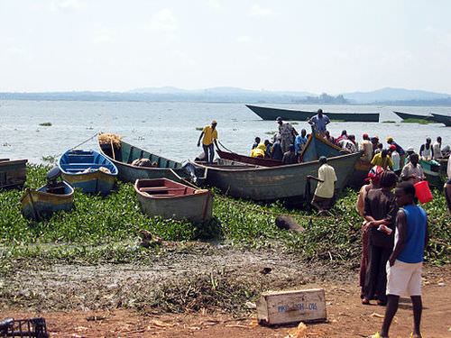
::非洲的主要河流包括尼罗河、尼日尔河、刚果河和赞比西河。尼罗河与亚马逊河争夺世界上最长的河流地位。白尼罗河分水岭始于东非的维多利亚湖,青尼罗河分水岭始于埃塞俄比亚的塔纳湖。尼日尔从尼日利亚开始,穿过西非。刚果河横跨赤道,有一个大型热带排水流域,该流域的供水量仅次于亚马逊河。南部赞比西河以赞比亚和津巴布韦边界上广泛的维多利亚瀑布而闻名。维多利亚瀑布被认为是世界上最大的瀑布。还有其他重要的河流,如奥兰河,它构成南非和纳米比亚之间边界的一部分。There are a number of large lakes in Sub-Saharan Africa. The largest is Lake Victoria, which borders several East African countries and is considered to be the second-largest lake in the world in surface area. Only Lake Superior in North America has a greater surface area. A number of large lakes are located in the rift valleys of the east. Three of the largest lakes along the western rift are Lake Malawi, Lake Tanganyika, and Lake Albert. To the northeast of these in Kenya is Lake Turkana, which reaches to the Ethiopian border. Lake Chad is located in the African Transition Zone on the border between Chad, Mali, and Nigeria. Lake Chad has been severely reduced in size in recent years.
::非洲撒哈拉以南地区有许多大湖,最大的是维多利亚湖,它与几个东非国家接壤,被认为是世界上地表面积第二大湖,只有北美的高级湖面积更大,东部裂谷中有许多大湖,西部裂谷中最大的三个湖泊是马拉维湖、坦噶尼喀湖和艾伯特湖,肯尼亚东北部是通向埃塞俄比亚边界的特尔卡纳湖,乍得湖位于乍得、马里和尼日利亚交界的非洲过渡区,近年来乍得湖的规模严重缩小。Fishers return with tilapia at Ggaba Landing Site, Lake Victoria, Uganda
::在乌干达维多利亚湖Ggaba Landing地点带罗拉比亚返回乌干达维多利亚湖的渔民返回
The equator runs through the center of Sub-Saharan Africa, providing tropical type A climates. These regions usually have more rainfall, resulting in lighter, leached-out soils that may not be as productive as regions with richer volcanic soils, such as those found in the rift valleys. Root crops are common in Africa, as are millet and corn.
::赤道横跨撒哈拉以南非洲中心,提供了热带A型气候。 这些地区通常降雨量更多,导致较轻和渗出土壤,这些土壤的生产力可能不如裂谷等火山土壤较为丰富的地区。 根作物在非洲很常见,小米和玉米也是如此。The savanna regions of the east and south have seasonal rains that affect the growing season. Soils in savanna areas are usually not as productive and cannot be depended on for the agricultural needs of growing populations. Savannas are usually grasslands or scrub forests with a seasonal precipitation pattern. Cattle and livestock grazing are common in savannas, and cattle migration follows the seasonal grazing conditions.
::东部和南部的稀树草原地区有季节性降雨,影响生长季节,热带地区的土壤通常不具有生产力,不能依赖日益增长的人口的农业需要,草原通常是草地,或用季节性降雨模式清洗森林,放牧和牲畜在热带地区很常见,牲畜迁移沿季节性放牧条件进行。In specific areas of Southern Africa, larger farming operations exist in type C climates. However, Sub-Saharan Africa does not have large regions of rich alluvial soils found in the Northern Hemisphere. The ever-growing agrarian population has always depended on the land for food and sustenance, but these conditions are not favorable for Africa’s future. Populations are growing faster than any increase in agricultural production.
::在南部非洲的特定地区,在C型气候中存在更大的耕作作业,然而,撒哈拉以南非洲在北半球没有大片富饶的冲积土壤。 不断增长的农业人口一直依赖土地作为食物和生计,但这些条件不利于非洲的未来。 人口增长速度快于农业生产的任何增长。Increasing populations in Sub-Saharan Africa are depleting the natural environment. Deforestation is occurring in areas where firewood is in high demand and trees are cut down faster than they can grow back. Expanding human populations are also encroaching on the natural biodiversity for which the African continent is renowned.
::撒哈拉以南非洲不断增长的人口正在消耗自然环境,砍伐森林发生在木柴需求高、树木砍伐速度快于其生长速度的地区。 扩大人口也在侵蚀非洲大陆著名的自然生物多样性。Animals such as rhinoceroses, elephants, and lions have been hunted to near extinction. The creation of game preserves and national parks has stemmed this tide, but poaching remains a serious problem even in these protected areas. Gorilla and chimpanzee populations have also been stressed by human population growth. These animals are being killed by humans for bush meat, and their habitats are being reduced by human activities.
::犀牛、大象和狮子等动物被猎杀到濒临灭绝的地步。 狩猎保护区和国家公园的建立遏制了这一潮流,但偷猎依然是一个严重问题,即使在这些保护区也是如此。 大猩猩和黑猩猩人口也因人类人口增长而深受其害。 这些动物正被人类杀死以获取树肉,其栖息地也因人类活动而减少。Sub-Saharan Africa does not have long mountain chains such as those found in the other continents. The Nile, Congo, and Niger Rivers are the main waterways. The Namib and Kalahari are the main deserts south of the African Transition Zone. The Great Rift Valleys are the longest physical features in East Africa.
::撒哈拉以南非洲没有象其他大陆那样长的山脉链,尼罗河、刚果河和尼日尔河是主要水道,纳米布河和卡拉哈里河是非洲过渡区以南的主要沙漠,大裂谷是东非最长的自然特征。Nile River Civilization
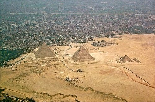
::尼罗河文明Human civilization also emerged along the Nile River valley of what is now Egypt. The pyramids and the Sphinx in the Giza Plateau just outside Cairo stand testimony to the human endeavors that took place here. Spring flooding of the Nile River brought nutrients and water to the land along the Nile Valley. The land could produce excess food, which subsequently led to the ability to support a structured, urbanized civilization.
::人类文明也在现在埃及的尼罗河谷一带出现。 位于开罗郊外的吉萨高原的金字塔和斯芬克斯证明了人类在此做出的努力。 尼罗河的春季洪水给尼罗河谷沿岸的土地带来了营养和水。 这片土地可以产生多余的粮食,从而导致有能力支持结构化的城市化文明。The Nile River is the "lifeblood" of the region. In the fifth century B.C.E., the ancient Greek historian Herodotus suggested that Egypt was “the gift of the Nile.” The dating for the beginning of the civilization along the Nile River is often in question, but Egyptologists estimate the first dynasty ruled both Upper and Lower Egypt around 3100 B.C.E. Upper Egypt is in the south and Lower Egypt is in the north because the Nile River flows north. The terms “Upper” and “Lower” refer to elevation.
::尼罗河是该地区的“生命之血 ” 。 在公元前五世纪,古希腊历史学家希罗多图斯(Herdototus)曾指出埃及是“尼罗河的礼物 ” 。 尼罗河沿岸文明开始的日期常常令人怀疑,但埃及学家估计,上埃及和下埃及的第一个王朝在公元前3100年左右统治上埃及和下埃及,上埃及在南埃及,下埃及在北埃及,因为尼罗河向北流动。 “上”和“下”这两个词指海拔。Geologists, using the erosion patterns of the Sphinx, estimate that it was constructed about 10,000 B.C.E. The ability of humans to harness the potential of the environment set the stage for technological advancements that continue to this day. The Egyptian civilization flourished for thousands of years and gave birth to a legacy that influenced their neighbors in the region, who benefited from their advancements
::利用斯芬克斯侵蚀模式的地质学家们利用斯芬克斯的侵蚀模式,估计它建造于公元前10 000年左右,人类利用环境潜力的能力为技术的发展创造了舞台,这些技术的发展一直持续到今天。 埃及文明繁荣了数千年,并产生了影响该地区邻居的遗产,这些邻居从他们的进步中获益。From north to south: parts of the city of Giza, the Giza Necropolis, and part of the Giza plateau.
::从北向南:吉萨市部分地区、吉萨内克罗波利斯和吉萨高原部分地区。
The human activities that created the civilizations in Mesopotamia and along Egypt’s Nile River gave humanity a rich heritage to help us understand our history. Many of our legends, stories, and myths have their origins in these cultures. Their cultural developments provided the basis for much of the Western world’s religious beliefs and early philosophical ideas.
::创造美索不达米亚和埃及尼罗河沿岸文明的人类活动为人类提供了丰富的遗产,帮助我们理解历史。 我们的许多传说、故事和神话起源于这些文化。 它们的文化发展为西方世界的许多宗教信仰和早期哲学思想提供了基础。The engineering feats needed to create the magnificent temples and pyramids have by themselves been studied and analyzed over the centuries. They give modern scientists and scholars a reason to pause and recognize the high level of organization and structure that went into developing and managing these civilizations. Various aspects of science and the arts were being developed by these ancient people. Writing, mathematics, engineering, and astronomy were becoming highly advanced. Artifacts such as clay tablets and hieroglyphs are still being discovered and interpreted. They shed additional light on the advancements of these civilizations and their contribution to our human civilization.
::几个世纪以来,创建宏伟的神庙和金字塔所需的工程成就本身就经过了研究和分析,使现代科学家和学者有理由停下来,认识到发展和管理这些文明的组织和结构水平很高,这些古代人正在发展科学和艺术的各个方面,写作、数学、工程学和天文学正在变得高度先进,泥土平板和象形文字等手工艺仍在被发现和解释,进一步揭示了这些文明的进步及其对人类文明的贡献。Kingdoms, Empires, and the Slave Trade
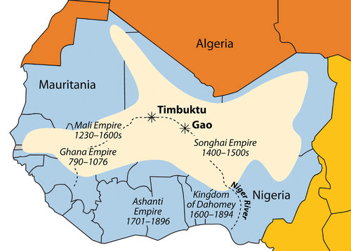
::王国、帝国和奴隶贸易West Africa was home to a number of large empires that shaped the culture and people of present-day Africa. The Ghana Empire (790–1076 C.E.) was responsible for one of the early consolidations of power in West Africa. Though its power and wealth were vast, it was only the first of a number of empires to arise in the region. After the Ghana Empire came the Mali Empire (1230–1600 C.E.), which was known for its wealth and size. The empire held major mining operations including gold, copper, and salt. Expanding along the Niger River and to the Atlantic coast, the Mali Empire extended over an area the size of Western Europe. Originally a federation of local groups, the empire incorporated many smaller provinces or kingdoms and had a major influence on the region’s laws and cultural heritage.
::西非是许多塑造当今非洲文化和人民的大型帝国的所在地,加纳帝国(790-1076 C.E.)是西非早期巩固权力的国家之一,尽管其权力和财富巨大,但它只是该地区出现的若干帝国中的第一个,在加纳帝国以其财富和规模而闻名的马里帝国(1230-1600 C.E.)诞生后,该帝国拥有巨大的采矿业务,包括黄金、铜和盐。 马里帝国在尼日尔河沿岸和大西洋沿岸扩展至西欧的面积。 马里帝国最初是一个由地方团体组成的联邦,组成了许多较小的省份或王国,对该地区的法律和文化遗产有着重大影响。The main empires of West Africa are indicated on this map. The shaded region indicates the furthest expanse of the Songhai Empire at its peak in the 16th century.
::地图上标明了西非的主要帝国,阴影区域显示的是16世纪最高峰的松海帝国最远的面积。
One of the indigenous states that evolved out of the Mali Empire was that of the Songhai people, who were located to the east of the main Mali Empire. The Songhai had been based around the city of Gao for centuries. In the 15th century, they established the Songhai Empire, one of the largest empires in African history. The city of Timbuktu became prominent during this period as an urban center, and its educational institutions became well known. In the end, the Songhai Empire was defeated by Moroccan Berber forces that splintered the empire into many smaller kingdoms and ethnic clans.
::由马里帝国演变而来的一个土著州是位于马里主要帝国东面的Songhai人。Songhai人几个世纪以来一直以高城为基地。在15世纪,他们建立了Songhai帝国,这是非洲历史上最大的帝国之一。在此期间,廷巴克图市作为城市中心变得显赫,其教育机构也广为人知。最后,Songhai帝国被摩洛哥的Berber部队打败,这些部队将帝国分裂成许多较小的王国和种族部族。South of the empires of the Niger River were coastal kingdoms, including the Ashanti and the Dahomey, which flourished during the colonial era. The local African groups had to contend with the colonial European traders and invaders, which had superior weapons and different technology. Besides the mining resources of gold, copper, salt, and ivory, the slave trade was a driving force that attracted trade ships from various European countries.
::尼日尔河各帝国的南端是沿岸王国,包括在殖民时代蓬勃发展的阿桑提和达荷美,当地的非洲集团不得不与拥有先进武器和不同技术的欧洲殖民贸易商和入侵者进行斗争。 除了金、铜、盐和象牙的开采资源外,奴隶贸易是吸引欧洲不同国家贸易船的驱动力。The Ashanti Empire was located along the Atlantic coast in an inland region of what is now Ghana and Ivory Coast. This area served as a trading corridor where goods from the northern regions crossed to make their way to the coastal trading towns. The Ashanti Empire took advantage of the trade opportunities and became wealthy. By the time the Europeans arrived, Ashanti trade relationships were well established and capable of supplying the colonial ships with slaves, ivory, and gold. The coastal area of Ghana was known as the Gold Coast during colonial times. Similarly, the country of Ivory Coast (Côte d’Ivoire) got its name from its participation in the elephant ivory trade.
::阿桑蒂帝国位于大西洋沿岸,位于加纳和象牙海岸的内陆地区,是北方地区货物过境前往沿海贸易城镇的贸易走廊,阿桑蒂帝国利用贸易机会致富,到欧洲人到达时,阿桑蒂贸易关系已经牢固建立,能够向殖民船只提供奴隶、象牙和黄金,加纳沿海地区在殖民时代被称为黄金海岸,同样,科特迪瓦也从参与象牙贸易中获得了名字。This region of West Africa bordering the Atlantic was called the Slave Coast because of the high number of local people from this area who were sold into the European slave trade and shipped to the Americas. The once powerful Kingdom of Dahomey, east of the Ashanti Empire, was heavily involved in the slave trade. Slave trading with Europeans brought them rifles and other firearms that were useful in conflicts with their enemies. A major slave state along the Slave Coast, the kingdom became hated for selling its war captives into transatlantic slavery rather than killing them, as was the custom in warfare. The Kingdom of Dahomey became the country of Benin after the colonial era.
::与大西洋接壤的西非这个区域被称为奴隶海岸,因为该地区大量当地人被卖进欧洲奴隶贸易,运到美洲;曾经强大的阿散蒂帝国以东达荷美王国大量参与奴隶贸易;与欧洲人进行奴隶贸易,带给他们步枪和其他枪支,这些枪支有助于与敌人发生冲突;在奴隶海岸一带的一个主要奴隶国,该王国因将战俘出售给跨大西洋奴隶而不是杀害他们而遭到憎恶,正如战争习惯一样;在殖民时代之后,达荷美王国成为贝宁国。The slave trade brought wealth to many of the slave-trading kingdoms on the African coast. The demand for slaves pushed many of the African kingdoms to expand their slave-trading activities, capturing more individuals whom they could sell to European slave traders. Millions of Africans were captured by other Africans to be sold into slavery, placed on ships, and sent to slave owners in the Americas. The total number sold into the Atlantic slave trade will never be known, but estimates range between 10 and 12 million.
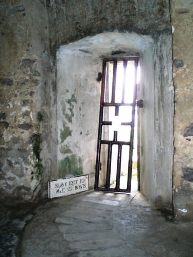
::奴隶贸易给非洲沿岸许多奴隶贸易王国带来了财富,对奴隶贸易的需求迫使许多非洲王国扩大奴隶贸易活动,抓获了更多他们可以卖给欧洲奴隶贸易商的人。 数百万非洲人被其他非洲人抓去当奴隶,被置于船上,并被送往美洲的奴隶主手中。 出售到大西洋奴隶贸易的总人数永远不会为人所知,但估计在1 000万到1 200万之间。Slaves kept for shipment were held in dungeons awaiting the arrival of the slave ships. This was the last doorway that slaves from Elmina, Ghana, saw on their way from the dungeon to the slave ship.
::这是加纳Elmina的奴隶在从地牢到奴隶船的路上看到的最后一道通道。
States and kingdoms existed throughout Sub-Saharan Africa. Early kingdoms flourished in the region that is now Ethiopia. East Africa’s Axum Empire was an example of the powers of the early African savanna kingdoms located in the east.
::撒哈拉以南的非洲各地都有国家和王国。 早期的王国在现在的埃塞俄比亚这个地区蓬勃发展。 东非的阿克苏姆帝国就是位于东部的早期非洲热带雨林王国权力的例子。The struggles between Islam and Christianity divided the region and gave way to the African Transition Zone, which serves as the dividing line between the two religions. Ethiopia has retained its Christian heritage, while to the north and east Islam has prevailed.
::伊斯兰和基督教之间的斗争使该地区分裂,让位于非洲过渡区,该区是两种宗教之间的分界线,埃塞俄比亚保留了其基督教传统,而北部和东部则占上风。South of the equator, the ruins of Great Zimbabwe give testimony to the regional base of power that existed there in centuries past. The Zulu Empire thrived in the 19th century in the region that is now South Africa.
::在赤道南部,大津巴布韦的废墟证明了几个世纪前存在的地区权力基础。 祖鲁帝国在十九世纪在如今的南非地区蓬勃发展。Colonialism in Sub-Saharan Africa
::在撒哈拉以南非洲的殖民主义Wherever you go in the world, the impact of European colonialism is evident. Sub-Saharan Africa was broadly affected by colonial activities, the legacy of which can be recognized to this day. Colonial powers of Europe ventured into Africa to claim colonies. Many African groups were instrumental in capturing and holding slaves to trade with the European merchants.
::无论你身处何地,欧洲殖民主义的影响是显而易见的。 撒哈拉以南非洲广泛受到殖民活动的影响,其遗产至今仍可以得到承认。 欧洲殖民势力冒险进入非洲,要求获得殖民地。 许多非洲团体在抓获和扣押奴隶与欧洲商人交易方面起了作用。By 1900, European colonial powers had claimed most of Africa. Only the Kingdom of Ethiopia and the area of Liberia, which was established as a home for freed slaves, remained independent. In 1884, Otto von Bismarck of Germany hosted the Berlin Conference, which to a great degree determined how Africa was colonized. This conference included 14 colonial European countries and the United States, and its purpose was to divide Africa and agree on colonial boundary lines.
::到1900年,欧洲殖民列强已拥有非洲的大部分领土,只有埃塞俄比亚王国和作为自由奴隶家园而建立的利比里亚地区仍然独立,1884年,德国的奥托·冯·比斯马克主办了柏林会议,该会议在很大程度上决定了非洲如何被殖民化,这次会议包括14个殖民地欧洲国家和美国,其目的是分裂非洲,商定殖民边界线。Germany had few claims in Africa. Bismarck was hoping to benefit by playing the other countries against each other. At the time, more than 80 percent of Africa remained free of colonial control. On a large map of Africa, claims were argued over and boundary lines were drawn according to European agreements.
::德国在非洲没有多少权利主张。 俾斯麦希望通过相互对立而让其他国家受益。 当时,超过80%的非洲仍然没有殖民控制。 在一张大片的非洲地图上,人们提出了权利主张,并根据欧洲协议划定了边界线。There was little regard for the concerns of local ethnic groups. Colonial boundaries divided communities into separate colonies. Ethnic boundaries were disregarded. Often-warring groups were placed together in the same colony. The Europeans, seeking profits from cheap labor and resources, did not consider the local people or culture and often employed brutal measures to subdue the local people. Most of the current borders in Africa are a result of the Berlin Conference, and many of the geopolitical issues that confront Africa today can be traced back to this event specifically and to colonialism in general.
::殖民边界将社区划分为单独的殖民地,族裔边界被忽略,交战集团往往被安置在同一殖民地内,欧洲人从廉价劳动力和资源中谋利,不考虑当地人民或文化,经常采取残酷措施征服当地人民,目前非洲的大部分边界是柏林会议的结果,今天非洲面临的许多地缘政治问题可具体追溯到这一事件,一般而言可追溯到殖民主义。European colonialism remained strong in Africa until the end of World War II, which left many European countries economically depleted. In 1945, the United Nations (UN) was established. One of the primary UN objectives was to oversee the decolonization of European colonies. However, colonialism in Sub-Saharan Africa lingered on. It was not until the 1990s that the last colony was finally freed.
::欧洲殖民主义在非洲一直很强大,直到第二次世界大战结束,许多欧洲国家的经济已经枯竭。 1945年,联合国成立,联合国的首要目标之一是监督欧洲殖民地的非殖民化。 然而,撒哈拉以南非洲的殖民主义依然存在。 直到1990年代,最后一个殖民地才最终获得解放。The transition from colonies to independent nations created conflict. Civil wars were fought over who would be in power after the Europeans left. The transition to full independence has exacted a heavy toll from African countries but has resulted in stronger political structures and greater democratic liberties in many cases. The first country to gain independence in Sub-Saharan Africa was Ghana in 1957.
::从殖民地向独立国家的过渡引发了冲突。 内战是为了在欧洲人离开后谁掌权而爆发的。 向完全独立过渡给非洲国家造成了沉重的损失,但在许多情况下却导致了更强大的政治结构和更大的民主自由。 1957年,撒哈拉以南非洲第一个获得独立的国家是加纳。During the era of independence after World War II, the Cold War between the United States and the Soviet Union enticed many of the African countries to support one or the other of the superpowers. The political pressure that divided African countries during the Cold War has persisted and is the basis of some of the current political problems. The European countries extracted raw materials and minerals from their African colonies, as well as slave labor.
::在第二次世界大战后的独立时代,美国和苏联之间的冷战促使许多非洲国家支持一个或另一个超级大国。 冷战期间分裂非洲国家的政治压力持续不已,并且是目前一些政治问题的根源。 欧洲国家从非洲殖民地中开采原材料和矿物,以及奴隶劳动。Varying degrees of attention were given to education, medical care, and infrastructure development. The dependency that a colony had on a European country for economic income in some cases continued long after independence and currently continues. On the other hand, major technology transfers from Europe to Africa infused greater efficiencies into Africa’s economic activities. Colonialism and the Cold War did bring about, in an unfortunate manner, the benefits of structured governments and greater democratic processes for many areas of the realm.
::教育、医疗和基础设施的发展受到不同程度的关注,殖民地对欧洲国家的经济收入的依赖有时在独立后长期持续,目前仍在继续。 另一方面,从欧洲向非洲的重大技术转让给非洲经济活动带来了更大的效率。 殖民主义和冷战的确以不幸的方式带来了结构性政府的好处,也带来了许多领域的更大民主进程。European Colonies in Africa, 1884
::1884年非洲欧洲殖民地From Colonialism to Independence
::从殖民主义到独立The Independence Arch in Accra, Ghana, built to commemorate Ghana's independence. The national motto, Freedom and Justice, is boldly inscribed at the top of the arch.
::加纳阿克拉的独立拱门是为纪念加纳独立而建的。 国家座右铭“自由和正义”被大胆地刻在拱门的顶端。
The transition from European colony to an independent state has not necessarily been a civil transition for African countries. Likewise, independent African countries have struggled to create stable governments or peaceful conditions—though stable governments and peaceful conditions have been established in some cases. In nearly all cases, removing the colonial powers from Africa was only half of the battle toward independence. The other half was establishing a functional, effective government.
::从欧洲殖民地向独立国家的过渡并不一定是非洲国家的民事过渡。 同样,独立的非洲国家为建立稳定政府或和平条件而奋斗 — — 尽管在某些情况下已经建立了稳定的政府与和平条件。 几乎在所有情况下,将殖民国家从非洲移出只占独立斗争的一半。 另一半是建立一个运作正常、有效的政府。Though each country has taken a slightly different path, most former colonies have endured civil unrest, conflict, or warfare in their push for stable governments. Coups, fraudulent elections, military regimes, and corruption have plagued the leadership in a number of African countries. Civil unrest usually precedes a change in leadership, and political power regularly changes hands by a military coup or an overthrow of the current leader.
::尽管每个国家都走过一条略微不同的道路,但大多数前殖民地都经历了内乱、冲突或战争,推动稳定政府。 政变、欺诈性选举、军事政权和腐败困扰着一些非洲国家的领导。 内乱通常先于领导层的更迭,而政治权力经常因军事政变或推翻现任领导人而改变手势。The realm has had difficulty developing and maintaining effective political systems with democratic leadership. Political leaders have come and gone, many have been replaced before their terms were over, and a few have stayed long after their terms ended. When a leader is elected democratically, it is common to have widespread accusations of corruption, voter fraud, or ballot box scandals. Such government mismanagement and corruption have been common problems.
::在民主领导下发展和维持有效政治制度方面,国家一直面临重重困难。 政治领袖们来来去去去,许多在任期结束前被替换,还有几个国家在任期结束后久留。 当一个民选领导人以民主方式当选时,腐败、选民欺诈或选票箱丑闻等广泛指控是司空见惯的。 这种政府管理不善和腐败一直是常见的问题。After the colonial era, it was not uncommon for new leaders to be connected to the old colonial power and to adopt the language and business arrangements of the European colonizer. This gave them an advantage over their competitors and provided a means of income gained by the support of their former European colonial business partners. The colonial business partners often wanted to keep ties with their former colonies to continue to profit from their resources. Many of these leaders stayed in power because of military backing or authoritarian rule funded by the profits from selling minerals or resources to their former colonial masters.
::在殖民时代之后,新领导人与旧殖民国家建立联系,并采用欧洲殖民者的语言和商业安排,这并非罕见,这使他们比其竞争者优越,并提供了通过支持其前欧洲殖民商业伙伴获得收入的手段;殖民商业伙伴往往希望与其前殖民地保持联系,以继续从资源中获益;许多这些领导人由于军事支持或独裁统治而继续掌权,这些支持或独裁统治的资金来源是向前殖民主子出售矿物或资源所得利润。A few countries are still struggling to bring about some type of order and unity. However, there have been democratic and relatively stable progressive governments in Africa that have emerged from the transition in recent years. This is a hopeful trend for the future.
::少数国家仍在为建立某种秩序和团结而挣扎,然而,近年来非洲过渡后出现了民主和相对稳定的进步政府,这是未来充满希望的趋势。It is important to note that the objective of colonialism was to connect a colony with the homeland, not to connect African countries to each other. The legacy of this paradigm is that there is little cooperation between African countries today. Each individual country interacts more with its European colonial counterpart with regard to trade, economics, and cultural dynamics.
::必须指出,殖民主义的目标是将殖民地与家园连接起来,而不是将非洲国家连接起来,这种模式的遗产是非洲国家之间今天几乎没有合作,每个国家在贸易、经济和文化动态方面都与其欧洲殖民对手进行更多的互动。European colonialism isolated African countries from each other. Colonial powers often built new port cities to extract goods and resources from their colonies. They also developed transportation systems from the new ports to the interior to collect the resources and bring them back to the port. However, the colonial powers did not build a network of transportation systems that connected the region as a whole.
::欧洲殖民主义使非洲国家相互孤立,殖民强国往往建造新的港口城市,从殖民地中提取货物和资源,它们还开发了从新港口到内地的运输系统,以收集资源并将其带回港口,但殖民强国并没有建立连接整个区域的运输系统网络。The current wave of globalization based on corporate colonialism continues to encourage the same pattern of discouraging interaction between countries in Africa. Instead, there is a concentration on trading with more economically powerful non-African countries. Most of the interaction between countries is a result of crisis or warfare, in which case large numbers of refugees cross the border into neighboring countries for personal survival or security.
::目前以公司殖民主义为基础的全球化浪潮继续鼓励同样的阻碍非洲国家之间互动的模式,而是集中于与经济实力较强的非非洲国家进行贸易,而国家之间的大部分互动是危机或战争造成的,在这种情况下,大批难民为了个人生存或安全而越过边界进入邻国。To begin to work together and promote trade, common transportation, security, and industry, 15 West African states came together in 1975 to create the . Since then, additional political and economic agreements have been signed by various African countries. In 2001, the more expansive African Union was created to help African states compete in the international marketplace.
::为了开始共同努力,促进贸易、共同运输、安全和工业,西非15个国家于1975年聚集一堂,共同创建了这一体系。 此后,非洲各国签署了更多的政治和经济协议。 2001年,建立了范围更广的非洲联盟,以帮助非洲国家在国际市场上竞争。Key Takeaways
::密钥外出-
Sub-Saharan Africa includes the African Transition Zone and the regions south of the Sahara. The African Transition Zone is a transitional zone between type A and type B climates and between the religions of Islam and Christianity.
::撒哈拉以南非洲包括非洲过渡区和撒哈拉以南地区,非洲过渡区是A类气候和B类气候之间以及伊斯兰教和基督教宗教之间的过渡区。 -
Sub-Saharan Africa is a realm of plateaus and basins with four main river systems. Mountain ranges, volcanic peaks, and large lakes are found in or along the rift valleys of eastern Africa. The rift valleys were created by tectonic activity.
::撒哈拉以南非洲是一个高原和流域地区,有四大河流系统,东部非洲裂谷内或沿裂谷发现了山脉、火山峰和大湖,断裂谷是由构造活动造成的。 -
Before the colonial era, many African kingdoms dominated regions of Sub-Saharan Africa. West Africa had a number of great kingdoms. Kingdoms along the coast contributed to the slave trade.
::在殖民时代之前,许多非洲王国统治着撒哈拉以南非洲地区,西非拥有许多伟大的王国,沿岸的王国助长了奴隶贸易。 -
European countries colonized almost the entire realm of Sub-Saharan Africa. European powers made agreements during the 1884 Berlin Conference to divide the realm and create boundary lines between their African colonies. Many of the lines remain as the current borders today.
::欧洲大国在1884年柏林会议期间达成协议,在它们的非洲殖民地之间划分和划定边界线。 许多边界线仍然是当今的边界线。 -
Colonies were designed to provide labor and resources to the homeland. Port cities, transportation systems, and other infrastructure were implemented to benefit the imperial power without regard for the development of the colony.
::殖民地旨在为家园提供劳动力和资源,港口城市、交通系统和其他基础设施的实施有利于帝国主义国家,而不顾殖民地的发展。 -
African colonies received independence after World War II. The transition from colonies to independent countries has been plagued by civil war, political chaos, or economic devastation.
::非洲殖民地在第二次世界大战后获得独立。 从殖民地向独立国家的过渡受到内战、政治混乱或经济破坏的困扰。
Vocabulary Terms
::词汇术语术语Chapter 8.1 Introducing the Realm
::第8.1章 介绍王国Berlin Conference
::柏林会议 柏林会议A meeting of European Nations in 1884-1885 at which countries agreed on the rules in colonizing Africa. The Europeans did not take into account existing boundaries and/or ethnic divisions.
::1884年至1885年召开的一次欧洲国家会议,会上各国就非洲殖民化的规则达成了一致意见,欧洲人没有考虑到现有的边界和/或种族分歧。cataract
::白内障White water rapids that can also include waterfalls
::还可以包括瀑布在内的白水流Congo Basin
::刚果盆地Tropical rain forest located in Central Africa. The Congo River runs through this basin.
::位于中非的热带雨林,刚果河穿过这一盆地。Lake Victoria
::维多利亚湖The largest lake in Africa, it is the source of the Nile River
::非洲最大的湖泊,是尼罗河的源头Mount Kilimanjaro
::乞力马扎罗山Africa's tallest peak, a volcano located in Tanzania
::非洲最高的山峰 位于坦桑尼亚的火山Rift Valley
::裂谷A valley created by the moving apart of tectonic plates. This exists in East Africa.
::由地壳板块分离形成的山谷, 存在于东非。Sahara Desert
::撒哈拉沙漠Largest desert in the world measuring over 3,000 miles across Northern Africa
::全世界最大的沙漠 横跨北非3000英里savanna
::热带草原Flat, grassy, mostly treeless plains located in the tropical regions of Africa
::位于非洲热带地区的平原Applying Knowledge
::应用知识Interactive Notebook Activities
::互动笔记活动-
Determine
which of the countries in Sub-Saharan Africa are now experiencing civil war or national unrest over political leadership.
::确定撒哈拉以南非洲哪些国家目前正经历内战或全国政治领导层动乱。 -
Analyze
which countries of the realm have the most stable governments.
::分析该地区哪些国家拥有最稳定的政府。
Discussion and Study Questions
::讨论和研究问题-
What are the main boundaries that define Sub-Saharan Africa?
::界定撒哈拉以南非洲的主要边界是什么? -
Where is the African Transition Zone? What are the main transitions that this zone represents?
::非洲过渡区在哪里?非洲过渡区代表的主要过渡是什么? -
What geological phenomenon has created the rift valleys of the east? What physical geographic features are found here?
::东方裂谷是由什么地质现象造成的?这里有什么物理地理特征? -
What are some of the general environmental issues that can be found throughout the realm of Sub-Saharan Africa?
::在整个撒哈拉以南非洲地区可以发现哪些一般性环境问题? -
Name the African kingdoms that were involved in the supply of humans for the European slave trade.
::指参与为欧洲奴隶贸易供应人命的非洲王国。 -
How did imperial powers in Africa cultivate their colonies’ dependence on the mother countries?
::非洲帝国列强如何培养殖民地对祖国的依赖? -
When did the colonies in Sub-Saharan Africa gain their independence?
::撒哈拉以南非洲的殖民地何时获得独立? -
What has been the usual pattern of transition from colonies to independent countries?
::从殖民地向独立国家过渡的通常模式是什么? -
What country was the first in Sub-Saharan Africa to gain its independence? In what year did it gain independence?
::撒哈拉以南非洲第一个获得独立的国家是谁? 在哪一年获得独立? -
How are the Sub-Saharan African countries continually isolated from their neighbors in the global economy?
::撒哈拉以南非洲国家如何在全球经济中不断与邻国隔绝?
Real-World Geography Exercise
::现实世界地理演习-
Using
, complete the following activities:
-
Locate each place on the bulleted list below.
::在下面的子弹名单上 找到每个地方 -
Find the nearest city with an international airport in proximity to each location on the bulleted list below.
::找到最近的城市,在下面子弹清单上每个地点附近有一个国际机场。 -
Calculate the distance and travel time by plane to each city from the
.
::乘飞机计算距离和旅行时间,从该城市飞往每个城市。
::使用以下活动,完成以下活动: 定位以下圆点列表中的每个地点; 找到最近的城市,在下面的圆点列表中的每个地点附近有一个国际机场。 计算从该城市飞往每个城市的飞机的距离和飞行时间 。 -
Locate each place on the bulleted list below.
-
Using
, determine the latitude and longitude for each location on the bulleted list below.
::使用,确定以下子弹列表中每个位置的纬度和经度。 -
Be prepared to share and discuss your answers.
::准备分享和讨论你的答案
-
African Transition Zone
::非洲过渡区 -
Blue Nile
::青青尼罗州 -
Cape of Good Hope
::美好希望角 -
Cape Ranges
::开角距离 -
Central Africa
::中部非洲中部非洲中部非洲 -
Congo River
::刚果河 -
East Africa
::东非东非东非 -
Ethiopian Plateau
::埃塞俄比亚高原 -
Kalahari Desert
::卡拉哈里沙漠 -
Lake Albert
::阿尔贝湖 -
Lake Chad
::乍得湖 -
Lake Malawi
::马拉维湖 -
Lake Tana
::塔纳湖 -
Lake Tanganyika
::坦噶尼喀湖 -
Lake Turkana
::特库卡纳湖 -
Lake Victoria
::维多利亚湖 -
Madagascar
::马达加斯加 马达加斯加 -
Mt. Cameroon
::Mt. 喀麦隆 -
Mt. Kilimanjaro
::乞力马扎罗山 -
Namib Desert
::Namib 沙漠 -
Niger River
::尼日尔河 -
Rwenzori Mountains
::鲁文佐里山脉 -
Southern Africa
::南部非洲南部非洲 -
Timbuktu
::廷巴克图 -
Victoria Falls
::维多利亚瀑布 -
West Africa
::西非西非 -
White Nile
::白尼罗河 -
Zambezi River
::赞比西河
Videos for Geography Enrichment
::地理丰富视频Helpful Websites for the Study of Geography
::地理研究有用网站is an encyclopedia funded by the Canadian government covering all branches of knowledge. Their scholarly collection includes interactive materials.
::该百科全书由加拿大政府资助,涵盖所有知识分支,其学术收藏包括交互式材料。provides information on the people, history, government, economy, energy, geography, communications, transportation, military, and transnational issues for the world's entities.
::向世界各实体提供关于人民、历史、政府、经济、能源、地理、通信、运输、军事和跨国问题的资料。is a US government website where you can find federal legislation, past and present, as well as information about the US legal system.
::是一个美国政府的网站,您可以在此找到过去和现在的联邦立法以及关于美国法律制度的信息。is a government agency website that provides current news, resources, topics of interest, information about drugs, careers in the DEA, and a tip hotline.
::是一个政府机构网站,提供最新消息、资源、感兴趣的话题、毒品信息、在缉毒局的职业以及一条小费热线。is the largest library in the world and provides manuscripts, files, information, pictures, and videos.
::图书馆是世界上最大的图书馆,提供手稿、文件、信息、图片和录像。is a US government agency website that allows users to search for and retrieve satellite images of Earth.
::这是一个美国政府机构的网站,用户可以搜索和检索地球的卫星图像。is a US government website that provides historical documents, photos, records, publications, and educator resources.
::这是一个美国政府网站,提供历史文件、照片、记录、出版物和教育资源。is a US government agency website that provides weather-related information and ocean research.
::是一个提供气象信息和海洋研究的美国政府机构网站。is a website by the United States Geological Survey and other federal, state, and local agencies that delivers topographic information for the United States.
::这是美国地质调查局和其他联邦、州和地方机构为美国提供地形信息的网站。is a massive central data source and a handy way to graphically compare nations.
::是一个庞大的中央数据源,是用图形比较国家的一种方便方式。is a website that measures most locations in the world for air pollution in real time.
::是一个实时测量世界上大多数空气污染地点的网站。is a unique statistical database, which allows you to research and compare a multitude of different data on US states.
::这是一个独特的统计数据库, 使你能够研究和比较关于美国各州的多种不同数据。is an international organization founded in 1945 and made up of 193 member states. The UN maintains international peace and security, protects human rights, delivers humanitarian aid, promotes sustainable development, and upholds international law.
::联合国是一个国际组织,成立于1945年,由193个成员国组成。 联合国维护国际和平与安全,保护人权,提供人道主义援助,促进可持续发展,维护国际法。is a US government agency that provides a population clock, data, surveys, statistics, a library with information and infographics, news about the economy, and much more.
::这是一个美国政府机构,它提供人口钟、数据、调查、统计、一个拥有信息和信息资料的图书馆、关于经济的新闻,以及更多。is a US government agency website that provides scientific information about the natural hazards that threaten lives, the natural resources we rely on, the health of our ecosystems and environment, and the impacts of climate and land-use change.
::这是一个美国政府机构的网站,提供科学信息,说明威胁生命的自然危害、我们赖以生存的自然资源、生态系统和环境的健康以及气候和土地使用变化的影响。is a US government website that provides the latest presidential news, information about the budget, policy, defense, and many more topics.
::提供最新总统新闻、预算、政策、国防等资讯, 以及更多议题。is under the United Nations and provides leadership on matters critical to health, shapes the research agenda on health, and monitors the health situation and assessing health trends around the world. Their website provides information on the state of health around the world, outbreaks, current health news, and more.
::网站提供世界各地卫生状况、疫情爆发、最新卫生新闻等信息。is an intergovernmental organization that regulates international trade. The website provides information on the history of the multilateral trading system, featured videos, news and events, trade topics, and more.
::该网站提供关于多边贸易体系历史的信息、视频、新闻和事件、贸易专题等等。 -
Summarize the basic geography of Sub-Saharan Africa.