东非(1天)
章节大纲
-
Chapter Challenges
::章次 挑战-
Summarize the physical layout and features of East Africa, including the Great Rift Valley.
::总结了东非,包括大裂谷的实际布局和特征。 -
Outline the significance that the wildlife and natural beauty of vast regions such as the Serengeti have for the economic activities of the region.
::概述塞伦盖蒂等广大地区的野生生物和自然美貌对该区域经济活动的重要性。 -
Explain how each country in East Africa is different from the others and what geographic attributes they have in common.
::说明东非每个国家与其他非洲国家有何不同,它们具有哪些共同的地理属性。 -
Analyze the affect the African Transition Zone has had on the Horn of Africa.
::分析非洲过渡区对非洲之角的影响。 -
Learn how and why the country of Somalia is divided into several political regions.
::了解索马里如何和为什么被划分为几个政治区域。
Student Learning Objectives
::学生学习目标TEKS Regional Unit 08 Africa; Chapter 8.6 East Africa
::TERS 区域股 08 非洲;第8.6章东非WG.3B Describe the physical processes that affect the environments of regions, including weather, tectonic forces, erosion, and soil-building processes.
::WG.3B 描述影响区域环境的物理过程,包括天气、构造力、侵蚀和土壤建设过程。WG.3C Examine the physical processes that affect the lithosphere, atmosphere, hydrosphere, and biosphere.
::WG.3C 审查影响地圈、大气、水圈和生物圈的物理过程。WG.4Q Explain how elevation, latitude, wind systems, ocean currents, position on a continent, and mountain barriers influence temperature, precipitation, and distribution of climate regions.
::WG.4Q 解释高海拔、纬度、风力系统、洋流、大陆位置、山地屏障如何影响气候区域的温度、降水量和分布。WG/4B Describe different landforms and the physical processes that cause their development.
::WG/4B 描述不同的土地形态和导致其发展的物理过程。WG.8A Compare ways that humans depend on, adapt to, and modify the physical environment, including the influences of culture and technology.
::WG.8A 比较人类依赖、适应和改变自然环境的方式,包括文化和技术的影响。WG.8C Evaluate the economic and political relationships between settlements and the environment, including sustainable development and renewable/non-renewable resources.
::WG.8C 评价住区与环境之间的经济和政治关系,包括可持续发展和可再生/不可再生资源。WG.9A Identify physical and/or human factors such as climate, vegetation, language, trade networks, political units, river systems, and religion that constitute a region.
::WG.9A 查明构成区域的自然和/或人类因素,如气候、植被、语言、贸易网络、政治单位、河流系统和宗教。WG.12A Analyze how the creation, distribution, and management of key natural resources affects the location and patterns of movement of products, money, and people.
::WG.12A 分析关键自然资源的创造、分配和管理如何影响产品、货币和人员流动的地点和模式。WG.18A Analyze cultural changes in specific regions caused by migration, war, trade, innovations, and diffusion.
::WG.18A 分析移徙、战争、贸易、创新和传播在特定区域造成的文化变化。WG.22A Design and draw appropriate graphics such as maps, diagrams, tables, and graphs to communicate geographic features, distributions, and relationships.
::WG.22A 设计和绘制适当的图形,如地图、图表、表格和图表,以交流地理特征、分布和关系。WG.22C Use geographic terminology correctly.
::WG.22C 正确使用地理术语。WG.22D Use standard grammar, spelling, sentence structure, and punctuation.
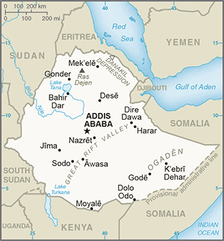
::WG.22D 使用标准语法、拼写、句子结构和标点。East Africa
::东非东非东非Physical Geography
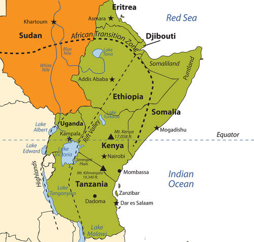
::物理地理East Africa is a region that begins in Tanzania in the south and extends north through the great grasslands and scrub forest of the savannas of Kenya and Uganda and then across the highlands of Ethiopia, including the Great Rift Valley. The region also comprises the countries of Somalia, Djibouti, and Eritrea, which are located in the African Transition Zone between North Africa and Sub-Saharan Africa.
::东非是一个从南部坦桑尼亚开始的区域,向北延伸,穿过肯尼亚和乌干达大草原的大草原和森林,然后穿过埃塞俄比亚高原,包括大裂谷,该区域还包括索马里、吉布提和厄立特里亚等国,这些国家位于北非和撒哈拉以南非洲之间的非洲过渡区内。Rwanda and Burundi are physically in East Africa but are covered in the chapter of Central Africa because of their border activities with the Congo. The world’s second-largest lake by surface area is Lake Victoria, which borders Uganda, Tanzania, and Kenya. Lake Victoria provides fish and fresh water for millions of people in the surrounding region. The White Nile starts at Lake Victoria and flows north to the city of Khartoum in Sudan, where it converges with the Blue Nile to become the Nile River. The source of the Blue Nile is Lake Tana in the highlands of Ethiopia.
::卢旺达和布隆迪地处东非,但由于它们与刚果的边界活动而成为中非的分会。按地表面积划分,世界第二大湖泊是维多利亚湖,与乌干达、坦桑尼亚和肯尼亚接壤。维多利亚湖为周边地区数百万人提供鱼和淡水。白尼罗河从维多利亚湖开始,向北流向苏丹喀土穆市,与青尼罗河汇合,成为尼罗河。青尼罗河的起源是埃塞俄比亚高原的塔纳湖。Map of East Africa
::东非地图
The highest mountain in Africa, Mount Kilimanjaro (19,340 feet), is located in Tanzania near the border with Kenya. The second highest peak, Mount Kenya (17,058 feet), located just north of the country’s capital of Nairobi, near the equator, is the source of Kenya’s name. Both mountains are inactive volcanoes and have permanent snow at their peaks. They provide fresh water, which flows down their mountainsides, to the surrounding areas.
::非洲最高的山是乞力马扎罗山(19 340英尺 ) , 位于坦桑尼亚与肯尼亚接壤的边境附近。 第二高的山峰是肯尼亚山(17 058英尺 ) , 位于肯尼亚首都内罗毕以北的肯尼亚山(17 058英尺 ) , 靠近赤道,是肯尼亚名字的来源。 这两座山都是无活动的火山,山顶上有永久的雪。 它们提供淡水,从山坡流到周边地区。Mountain ranges in the Western Highlands of the Congo have a greater effect on climate than these two massive peaks. For example, the Rwenzori Mountains on the Congo–Uganda border have permanent snow and glaciers and reach elevations of more than 16,000 feet. These ranges create a rain shadow effect that cuts off moisture for the region from the westerly equatorial winds
::刚果西部高原山区的山脉对气候的影响大于这两个巨大的山峰。 例如,刚果的鲁文佐里山脉(Rwenzori山)有永久的雪和冰川,达到超过16,000英尺的海拔。 这些山脉产生了雨影效应,切断了该地区从西赤道风的湿度。This same effect is created by the highlands of Ethiopia, which reach as high as 15,000 feet in elevation and restrict precipitation in areas to the east. The lower level of rainfall transforms much of the region from a tropical rain forest into a savanna-type landscape with few forests, more open grasslands, and sporadic trees. Dry desert-like conditions can be found in a number of places along the Great Rift Valley.
::埃塞俄比亚高地也造成了同样的效应,高地高至15 000英尺高,限制了东部地区的降水量,降雨量低使该地区大部分地区从热带雨林转变为热带雨林,热带雨林少有森林、更开阔的草场和零星树木,大裂谷沿线许多地方也出现了类似沙漠的干燥条件。The Great Rift Valley
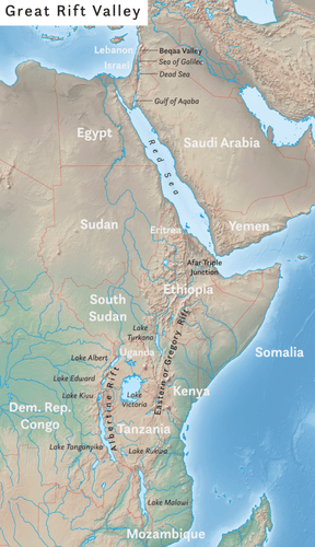
::大裂谷The African portion of the rift extends from Mozambique to the Red Sea. The valley is created by the movement of tectonic plates.
::裂谷的非洲部分从莫桑比克延伸到红海,由构造板块的移动形成。
The Great Rift Valley provides evidence of a split in the African Plate, dividing it into two smaller tectonic plates: the Somalian Plate and the Nubian Plate. The Great Rift Valley in East Africa is divided into the Western Rift and the Eastern Rift. The Western Rift runs along the border with the Congo. A series of deep water lakes run along its valley. On the western edge of the Western Rift are the highlands, which have a series of high-elevation mountain ranges, including the Rwenzori Mountains, the highest in the series. The Virunga Mountains on the Congo–Uganda border are home to endangered mountain gorillas. The Western Rift includes a series of deep water lakes, such as Lake Tanganyika, Lake Edward, and Lake Albert. Lake Victoria is located between the Western Rift and the Eastern Rift.
::大裂谷提供了非洲板块分裂的证据,将其分为两个较小的构造板块:索马里板块和努比亚板块;东非大裂谷分为西部裂谷和东部裂谷;西部裂谷沿与刚果接壤的边界运行;沿其河谷运行一系列深水湖泊;西部裂谷西部边缘为高原,包括鲁文佐里山脉,这是一系列最高的山脉。刚果-乌干达边境的维龙加山脉是濒危山区大猩猩的家园。西部裂谷包括一系列深水湖泊,如坦噶尼喀湖、爱德华湖和艾伯特湖。维多利亚湖位于西部裂谷和东部裂谷之间。The Eastern Rift does not have deep water lakes. Rather, it is a wide valley or basin with shallow lakes that do not have outlets. The lakes have higher levels of sodium carbonate and mineral buildup because of a high rate of evaporation. The differences in water composition of the lakes along the Eastern Rift vary from freshwater to extremely alkaline. Alkaline water creates an ideal breeding ground for algae and other species of fish, such as tilapia, which thrive in this environment.
::东裂谷没有深水湖,而是宽谷或盆地,浅湖没有出口,湖泊的碳酸钠和矿藏积累水平较高,因为蒸发率高,东裂谷湖水构成的差异从淡水到极碱性不等,藻类和其他种类的鱼类,如在这种环境中生长的罗非鱼,都有一个理想的繁殖地。Millions of birds feed off the abundant supply of algae and fish. Birds attract other wildlife, which in turn creates a unique set of environmental ecosystems. The eastern edge of the Eastern Rift is home to the inactive volcanic peaks of Mount Kilimanjaro and Mount Kenya. A number of other volcanic peaks are present in the Eastern Rift, such as Ol Doinyo Lengai, an active volcano.
::几百万只鸟类靠丰富的藻类和鱼类供养。鸟类吸引了其他野生动物,这反过来又创造了一套独特的环境生态系统。东裂谷东部边缘是乞力马扎罗山和肯尼亚山等无活动的火山峰的所在地。东裂谷也存在其他一些火山峰,如活跃的火山奥尔多尼奥·伦盖。The erosion patterns of the highlands have caused a buildup of sediments on the rift valley floor, creating a favorable environment for the preservation of biological remains, including both human and animal remains. Important fossils and bones of several hominid species have been found in the Great Rift Valley. One of the most famous finds came in 1974 when the nearly complete skeleton of an australopithecine nicknamed “Lucy.”
::高原的侵蚀模式导致裂谷谷底层的沉积物积聚,为保护生物遗骸,包括人类和动物遗骸创造了有利的环境。 在大裂谷中发现了一些重要的化石和一些有色人种的骨头。 最著名的发现之一发生在1974年,当时一个被称为“露西”的奥斯特罗洛皮西神庙几乎完全的骨架“露西 ” 。Lucy was discovered by anthropologist Donald Johanson. Noted anthropologists Richard and Mary Leakey have also done significant work in this region. Since the 1970's, remains of hominids from about 10 million years ago were discovered in the northern region of the Great Rift Valley. Discoveries at the 30-mile-long Olduvai Gorge indicate that early hominid species might have lived in the region for millions of years.
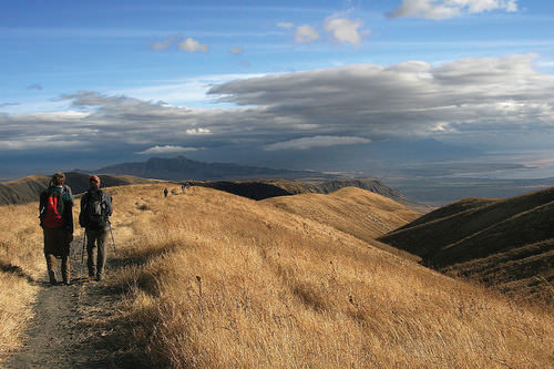
::露西是人类学家唐纳德·约翰森(Donald Johanson)发现的。著名的人类学家理查德(Richard)和玛丽·莱基(Mary Leakey)也在这个地区做了大量工作。 自1970年代以来,在大裂谷北部地区发现了大约1 000万年前的人类遗迹。 在30英里长的奥杜威峡谷的发现表明早期的人类物种可能已经在该地区生活了数百万年。Hiking the Great Rift Valley in Tanzania.
::在坦桑尼亚大裂谷远足Serengeti and Game Reserves
::塞伦盖蒂和狩猎保留地The Great Rift Valley and the surrounding savannas in Kenya and Tanzania are home to some of the largest game reserves in Africa, with a broad variety of big game animals. One of these large regions is the vast Serengeti Plain, located in northern Tanzania and southern Kenya. The governments of Tanzania and Kenya maintain national parks, national game reserves, and wildlife sanctuaries in their countries, most notably in the Serengeti Plain. Legal protection for as much as 80 percent of the Serengeti has been provided. The protections restrict hunting and commercial agriculture and provide protection status for the wildlife. The word Serengeti means “Endless Plains.”
::肯尼亚和坦桑尼亚的大裂谷及其周围的热带稀树草原是非洲一些最大的狩猎保护区的所在地,拥有各种各样的大型狩猎动物。这些大区域之一是位于坦桑尼亚北部和肯尼亚南部的辽阔的Serengeti平原。坦桑尼亚和肯尼亚政府在其国内维持国家公园、国家狩猎保护区和野生动物保护区,最明显的是塞伦盖蒂平原。为多达80%的塞伦盖蒂人提供了法律保护。保护限制了狩猎和商业农业,并为野生动物提供了保护地位。Serengeti一词的意思是“无尽的平原 ” 。Masai Giraffe in Serengeti National Park, Tanzania
::Masai Giraffe,坦桑尼亚塞伦盖蒂国家公园
The Serengeti Plain is host to an extraordinary diversity of large mammals and fauna. The largest migration of land animals in the world occurs in the Serengeti. Every fall and spring, as many as two million wildebeests, antelope, and other grazing animals migrate from the northern hills to the southern plains in search of grass and food. The , which is a UNESCO World Heritage Site, and the Ngorongoro Crater are located on the Tanzanian side of the border. The enormous crater is the basin of an extinct volcano that has been transformed into a protected national park for the animals that graze on the grassy plains. This is a dry region because the Ngorongoro Highlands create a rain shadow for the area.
::塞伦盖蒂平原是众多大型哺乳动物和动物的栖息地,世界上最大的陆地动物迁移发生在塞伦盖蒂;每年秋秋春,有多达200万只野生动物、羚羊和其他放牧动物从北部山丘迁移到南部平原,寻找草和食物;这是教科文组织的世界遗产地,恩戈龙戈罗山位于边界坦桑尼亚一侧;巨大的火山坑是一个已绝迹的火山盆地,已经转变成一个保护在草原上放牧的动物的国家公园;这是一个干燥的区域,因为恩戈龙戈罗高原为该地区创造了雨影。Dozens of other protected areas throughout Eastern Africa have been established in an effort to protect and sustain the valuable ecosystems for the large animals that have found their habitat encroached upon elsewhere by the ever-expanding human population. Kenya has more than 55 nationally protected areas that serve as parks, reserves, or sanctuaries for wildlife. The and are two of the more well-known protected areas.
::在整个东非建立了数十个其他保护区,以保护和维持大型动物的宝贵生态系统,这些大型动物的栖息地被日益扩大的人类人口侵占,肯尼亚有55个以上的国家保护区,作为野生动物的公园、保护区或保护区,是两个更著名的保护区。The “big five” game animals—elephants, rhinoceroses, lions, leopards, and buffalo—and all the other unique animals found in the same ecosystems, translate into income from tourists from around the world who wish to experience this type of environment. The national park systems in Uganda and Ethiopia have made provisions to provide more sanctuaries for wildlife in areas where the human population is growing and the political situation has not always been stable.
::“五大”游戏动物——类动物、犀牛、狮子、豹和水牛——以及在同一生态系统中发现的所有其他独特动物——转化为来自世界各地希望体验这种环境的游客的收入。 乌干达和埃塞俄比亚的国家公园系统已经做出安排,在人口不断增长和政治局势不总是稳定的地区为野生动物提供更多的保护区。Tanzania
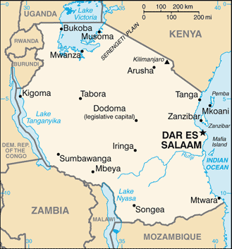
::坦桑尼亚 坦桑尼亚 坦桑尼亚
Map of Tanzania
::坦桑尼亚地图
Germany gained control of the region of what is now in their scramble for African territory in the late 1800's. Germany relinquished the colony to Britain after World War I. Off the coast of East Africa is the island of Zanzibar, which has been an island trading post for centuries and drew in shipping trade from the Middle East, India, and other parts of Africa. The spice trade attracted European ships throughout colonial times.
::德国在1800年代后期控制了目前争夺非洲领土的地区。 德国在第一次世界大战后将殖民地让给英国。 东非沿岸的桑给巴尔岛是桑给巴尔岛。 桑给巴尔岛数百年来一直是岛上贸易站,从中东、印度和非洲其他地区吸引了航运贸易。 香料贸易在整个殖民时代吸引了欧洲船只。During British occupation, the mainland region was called Tanganyika, named after the large lake on the eastern edge. In 1960, the colony gained independence from Great Britain, and four years later Zanzibar and Tanganyika came together to form the country of Tanzania. Zanzibar remains an important travel destination. Major tourism infrastructure has been developed there. The coastal city of Dar es Salaam is the primate city of the country and acts as the capital.
::在英国占领期间,大陆地区被称为坦噶尼喀,以东部边缘的大湖命名。 1960年,殖民地从英国获得独立,四年后桑给巴尔和坦噶尼喀共同组成坦桑尼亚国。桑给巴尔仍然是一个重要的旅游目的地。主要旅游基础设施已经在那里发展。沿海城市达累斯萨拉姆是该国的原始城市,是首都。In 1996, Dodoma was declared the official capital. Dodoma is a type of forward capital , because the declaration of Dodoma as the official capital was intended to move the political power inland, toward the country’s center. The parliament meets in Dodoma, but major government offices remain in Dar es Salaam, making Dar es Salaam the de facto capital of the country.
::1996年,多多马被宣布为官方首都。 多多马是一种前方首都,因为宣布多多马为官方首都是为了将政治权力向内向内向国内中心转移。 议会在多多马举行会议,但主要政府办公室仍留在达累斯萨拉姆,使达累斯萨拉姆成为该国事实上的首都。Tanzania is an agricultural country. As much as 80 percent of the people make their living off the land. The rural nature of the population signifies that the country is at the lower end of the index of economic development with larger families and lower incomes. An emphasis on tourism is a growing trend in Tanzania. The government has stepped up efforts to expand the tourism sector of the economy. Oil and natural gas exploration has also been emphasized in hopes of raising the level of national wealth.
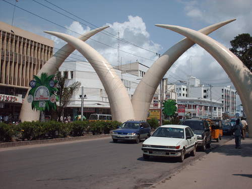
::坦桑尼亚是一个农业国家,多达80%的人口靠土地为生。农村人口的性质表明,该国在经济发展指数中处于低端,家庭和收入都比较大,收入也较低。坦桑尼亚对旅游业的强调是日益增长的趋势。政府加大了扩大旅游经济部门的力度。石油和天然气勘探也得到了强调,希望提高国家财富水平。The famous elephant tusks landmark in Mombasa, Kenya.
::肯尼亚蒙巴萨著名的大象象象牙里程碑。
There are more than 100 ethnic groups in Tanzania. Swahili, an indigenous language, is the lingua franca, and English is used in the higher legal courts and in the universities for higher education. Swahili is used as a second language throughout much of East Africa and serves as a major cultural connection between the many ethnic groups. Tanzania is unique in this aspect; the indigenous language of Swahili was chosen as the lingua franca rather than the colonial language. Most people learn at least two or three languages, depending on their circumstances. The religious balance of Tanzania’s population of more than 40 million people is almost evenly divided three ways amongst Christianity, Islam, and traditional religions.
::坦桑尼亚有100多个族裔群体。 斯瓦希里语是一种土著语言,是法语,在高等法院和高等教育大学中使用英语。斯瓦希里语在东非大部分地区被用作第二语言,是许多族裔群体之间的主要文化联系。坦桑尼亚在这方面是独一无二的;斯瓦希里语被选为法语,而不是殖民语言。大多数人根据自己的情况学习至少两三种语言。坦桑尼亚4 000多万人口的宗教平衡几乎在基督教、伊斯兰教和传统宗教之间平均分配了三种方式。Kenya
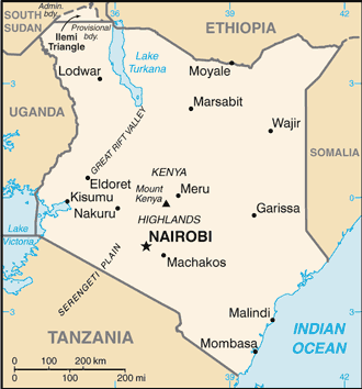
::肯尼亚 肯尼亚 肯尼亚 肯尼亚
Map of Kenya
::肯尼亚地图
During colonial times, the British considered the land area now called to be a Crown protectorate area. The coastal city of Mombasa has been an international shipping port for centuries and is now the busiest port in the region. Persian, Arab, Indian, and even Chinese ships made port in Mombasa during its earliest years to take part in the trade of slaves, ivory, and spices. Portugal sought early control of the trade center but eventually lost out to Britain.
::在殖民时代,英国人认为陆地地区现在被称为皇家保护区。 蒙巴萨沿海城市数百年来一直是国际航运港口,现在是该地区最繁忙的港口。 波斯、阿拉伯、印度甚至中国船只在最早的几年里在蒙巴萨港口进入奴隶、象牙和香料贸易。 葡萄牙寻求尽早控制贸易中心,但最终输给了英国。Arab and Middle Eastern shippers brought Islam to the region, and Europeans brought Christianity. Hinduism and Sikhism from India found their way into the country with workers brought over by the British to help build a railroad to Uganda. Kenya gained independence in 1963 and has worked throughout the latter part of the 20th century to establish a stable democratic government.
::阿拉伯和中东的托运人把伊斯兰教带到了该地区,欧洲人带来了基督教。 印度的印度教和锡克教找到了进入印度的道路,英国将工人带到了这个国家帮助建设一条通往乌干达的铁路。 肯尼亚于1963年获得独立,并在20世纪后半叶致力于建立一个稳定的民主政府。Nairobi, Kenya’s capital, has become a central core urban area that serves the greater East African region as an economic hub for development and globalization. The largest city in the region, Nairobi is continually expanding and draws in people from rural areas seeking opportunities and advantages. It also has become a destination for international corporations planning to expand business ventures into Africa. Kenya has experienced economic growth and decline as market prices and agricultural production have fluctuated.
::肯尼亚的首都内罗毕已成为一个核心城市中心地区,为大东非地区服务,成为发展和全球化的经济枢纽。 内罗毕是该地区最大的城市,正在不断扩大,吸引农村地区人民寻找机会和优势。 肯尼亚也成为国际公司计划将商业企业扩展到非洲的一个目的地。 随着市场价格和农业生产的波动,肯尼亚经历了经济增长和衰退。The Kenyan government has been working with the International Monetary Fund (IMF) and the World Bank to support its economic reform initiatives and reduce waste and corruption in its fiscal processes. The countries of Uganda, Tanzania, and Kenya developed the East African Community (EAC) as a trading bloc to support mutual development and economic partnerships.
::肯尼亚政府一直与国际货币基金组织(IMF)和世界银行合作,支持其经济改革倡议,减少财政过程中的浪费和腐败。 乌干达、坦桑尼亚和肯尼亚三国发展了东非共同体(EAC ) , 作为支持相互发展和经济伙伴关系的贸易集团。Kenya has more than 40 different ethnic groups, each with its own unique cultural history and traditions. Of the many ethnic groups in Kenya, the Maasai have gained international attention and are often given wide exposure in tourism information. The Maasai are a small minority of Kenya’s population but are known for wearing vivid attire and unique jewelry. Their historical lands have been the border region between Kenya and Tanzania.
::肯尼亚有40多个不同的族裔群体,每个民族都有独特的文化历史和传统。 在肯尼亚的许多族裔群体中,马萨伊人赢得了国际关注,并经常在旅游信息中受到广泛的宣传。 马萨伊人是肯尼亚人口中的少数,但以穿着生动的服装和独特的首饰而闻名。 他们的历史土地是肯尼亚和坦桑尼亚之间的边境地区。Cattle, a sign of wealth, have been at the center of Maasai traditions and culture and provide for their livelihood. Tourism brings to the surface the diversity of cultures that coexist within Kenya’s environmental attractions, and the country is working to enhance its international draw in the tourism marketplace.
::作为财富象征的牛,它一直处于马赛传统和文化的中心,养活他们的生计。 旅游业将在肯尼亚环境景点内共存的文化多样性带到了表面,而肯尼亚正在努力提高国际旅游市场吸引量。Uganda
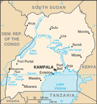
::乌干达乌干达
Map of Uganda
::乌干达地图
is a small, landlocked country on the northern shores of Lake Victoria. The Western Rift borders it on the west, forming both high mountains and deep lakes. Lakes Albert, Edward, and George are three of the larger bodies of water. The Nile River flows out of Lake Victoria through Lake Kyoga and Lake Albert on its way north, providing an abundant fresh water supply and a transportation route.
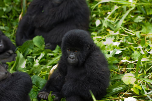
::西裂谷位于西部,形成高山和深湖。 艾伯特湖、爱德华湖和乔治湖是三大水体中的三块。 尼罗河从维多利亚湖流出,穿过基奥加湖和艾伯特湖向北,提供了丰富的淡水供应和运输路线。The Rwenzori Mountains and the Virunga Mountains shadow the country from the west. Mountain gorillas, an eastern gorilla sub-species, inhabit this region. They are extremely endangered. Only about 700 mountain gorillas live in Africa. One of the two main populations of gorillas lives in the national parks of the Virunga Mountains in Rwanda, Uganda, and the Congo. The second population is found only in a national park in Uganda. The lowland eastern gorilla population is also threatened, and their population continues to decline. Poaching, habitat loss, disease, and warfare have devastated their populations in the past century.
::鲁文佐里山脉和维龙加山脉从西面向下阴影着这个国家,山区大猩猩是东部大猩猩的次物种,居住在这一地区,濒临灭绝,只有大约700名山大猩猩生活在非洲,其中两大大猩猩主要居住在卢旺达、乌干达和刚果的维龙加山脉国家公园中,第二大猩猩只出现在乌干达的国家公园中,低地东部大猩猩人口也受到威胁,其人口继续下降,在过去一个世纪里,偷猎、生境损失、疾病和战争给非洲人口造成了破坏。Baby Mountain Gorilla in Virunga National Park
::维龙加国家公园中的婴儿山大猩猩
Uganda is a poor country and has experienced serious political and ethnic conflicts in recent decades. In 1971, the brutal dictator Idi Amin sought to rid the country of his opponents and many foreigners. He killed many of Uganda’s own people and destroyed the economy in the process. He was ousted in 1979 and lived in exile in Saudi Arabia until his death. Uganda was in conflict with Sudan in the 1990's, during the bloody civil war in neighboring Rwanda. Uganda sided with the Tutsi groups in the region and has had to deal with ethnic division within its own borders. Uganda has many troops engaged in the conflict along the unstable border region of the Congo.
::乌干达是一个穷国,近几十年来经历了严重的政治和种族冲突。1971年,残暴的独裁者伊迪·阿明试图除掉该国的反对派和许多外国人。他杀害了乌干达的许多人民,并在这一进程中摧毁了经济。1979年,他被驱逐,流亡在沙特阿拉伯,直到他去世。1990年代,在邻国卢旺达的血腥内战期间,乌干达与苏丹发生冲突。乌干达与该地区的图西族集团站在一起,不得不在自己的边界内处理种族分裂问题。乌干达有许多军队在刚果不稳定的边境地区参与冲突。Uganda is an agrarian state with natural mineral wealth. The potential for added national wealth through mineral extraction exists, but there is no way to fund the extraction operations. Agriculture is the principal employment of Uganda’s labor force, and most workers earn fewer than two dollars per day US equivalent. Coffee has been and continues to be a main export crop. Uganda is about the same size in terms of land area as the US state of Wyoming. Uganda has an estimated population of more than 39 million people. Population growth without economic growth places a heavy strain on Uganda’s natural resources.
::乌干达是一个拥有天然矿产财富的农业国家。 通过矿产开采增加国家财富的潜力已经存在,但无法为开采活动提供资金。 农业是乌干达劳动力的主要就业岗位,大部分工人每天收入不到两美元。 咖啡一直是并继续是主要出口作物。 乌干达的土地面积与美国怀俄明州大致相同。 据估计,乌干达人口超过3,900万。 没有经济增长的人口增长对乌干达自然资源造成了沉重的压力。Ethiopia
::埃塞俄比亚 埃塞俄比亚 埃塞俄比亚 埃塞俄比亚
Map of Ethiopa
::Ethiopa地图
With more than 105 million inhabitants, has the second largest population in Africa. Ethiopia was never colonized by the Europeans in the scramble for Africa, but during World War II, it suffered a brief occupation by Italy (1936–41). From 1930 to 1974, Emperor Haile Selassie ruled the country until he was deposed in a military coup. Many Rastafarians in Jamaica consider Selassie to be the second coming of Christ and a messiah for the African people. According to Rastafarian traditions, Ethiopia was the biblical Zion.
::拥有超过1.05亿人口,拥有非洲第二大人口。 埃塞俄比亚从未被欧洲人在争夺非洲时殖民化过,但在二战期间,它遭受了意大利的短暂占领(1936-41 ) 。 从1930年到1974年,海尔·塞拉西皇帝统治了这个国家,直到他在军事政变中被推翻。 牙买加的许多拉斯塔法里教徒认为塞拉西是基督的第二次诞生,也是非洲人民的救世主。 根据Rastafarian传统,埃塞俄比亚是圣经的锡安。After Selassie was deposed, the government shifted to a one-party Communist state. Successive years in Ethiopia were filled with massive uprisings, bloody coups, and devastating droughts, which brought about massive refugee problems and civil unrest. Famine in the 1980's caused the deaths of more than one million people. The Communist element in Ethiopia diminished when the Soviet Union collapsed in 1991. The country’s first multiparty elections were held in 1995.
::塞拉西被推翻后,政府转向了一党共产主义国家。 埃塞俄比亚连续几年充斥着大规模起义、血腥政变和毁灭性干旱,这导致了大规模的难民问题和内乱。 1980年代的饥荒造成100多万人死亡。 1991年苏联崩溃后,埃塞俄比亚共产党分子减少。 1995年举行了埃塞俄比亚第一次多党选举。The region of Eritrea had been a part of a federation with Ethiopia. In 1993, Eritrea declared independence, sparking a boundary war with Ethiopia that eventually concluded in a peace treaty and independence in 2000. The final boundary is still disputed. The breaking off of Eritrea left Ethiopia a landlocked country with no port city.
::1993年,厄立特里亚宣布独立,引发了与埃塞俄比亚的边界战争,最终于2000年缔结了和平条约和独立,最后的边界仍然存在争议,厄立特里亚的解体使埃塞俄比亚成为内陆国,没有港口城市。The capital and largest city in Ethiopia is Addis Ababa, which is the center for various international organizations serving East Africa and Africa in general, such as the African Union and the United Nations (UN) Economic Commission for Africa. This city is the hub of activity for the country and for international aid for the region.
::埃塞俄比亚首都和最大的城市是亚的斯亚贝巴,它是为东非和整个非洲服务的国际组织的中心,例如非洲联盟和联合国非洲经济委员会(联合国),是该国的活动中心,也是该区域国际援助的中心。The bustling center of Addis Ababa.
::亚的斯亚贝巴的繁忙中心
The Great Rift Valley bisects Ethiopia. Highlands dominate the northwest, and minor highlands exist southwest of the rift. The Ethiopian Plateau encompasses the Northwest Highlands and is home to Lake Tana, the source of the Blue Nile. Elevations on the Ethiopian Plateau average more than 5,000 feet, and the highest peak, Ras Dashan, reaches up to 14,928 feet.
::大裂谷分埃塞俄比亚两部分,高地以西北为主,小高地位于裂谷西南,埃塞俄比亚高原包括西北高地,是青尼罗河发源地塔纳湖的家园,埃塞俄比亚高地平均高5 000多英尺,最高山峰达14 928英尺。The climate includes sporadic rain in early spring. The typical rainy season extends from June to September, but the rest of the year is usually dry. The high elevations of the highlands cause a rain shadow effect in the deep valleys or basins on the dry side of the region. Eastern Ethiopia is arid, with desert-like conditions. The impact of overpopulation on the natural environment has been deforestation and higher rates of soil erosion. Thus continued loss of animal species is inevitable. Fortunately, Ethiopia has established natural parks and game reserves to protect wildlife and big game.
::气候包括初春零星降雨,典型的雨季从6月到9月,但今年的其余时间通常是干燥的。高地高海拔对该区域干旱一侧的深谷或盆地造成雨影效应。东埃塞俄比亚干旱,条件类似沙漠。人口过多对自然环境的影响是砍伐森林和土壤侵蚀率较高。因此,动物物种的继续损失是不可避免的。幸运的是,埃塞俄比亚建立了自然公园和游戏保护区,以保护野生动物和大型游戏。Ethiopia has been inhabited by divergent kingdoms and civilizations, giving rise to a rich heritage and many cultural traditions—so much so that Ethiopia is home to eight UNESCO World Heritage Sites. More than 60 percent of the population is Christian, and about 30 percent of the population is Muslim. Many traditional religions can be found in rural areas. In contrast to other African countries, Christianity came to Ethiopia directly from the Middle East rather than from European colonizers or missionaries from Western countries.
::埃塞俄比亚居住着不同的王国和文明,产生了丰富的遗产和许多文化传统,因此埃塞俄比亚是教科文组织八个世界遗产所在地的家园,60%以上的人口是基督徒,30%的人口是穆斯林,许多传统宗教可以在农村地区找到,与其他非洲国家不同,基督教直接来自中东,而不是来自欧洲殖民者或西方国家的传教士。In Ethiopia, Christianity was structured into the Ethiopian Orthodox Church, a church that has endured through centuries. Religious tradition claims that the Ethiopian Orthodox Church is in possession of the lost Ark of the Covenant, which once rested in the holy of holies in the great temple of Solomon in Jerusalem. Ethiopia does not use the Gregorian calendar, which is the calendar used in the most of the Western world. Instead, Ethiopia uses a calendar based upon the calendar of the Coptic Christian Church, which is about eight years behind the Gregorian calendar because of differences in how the year is calculated and in differences in the dating of the life of Jesus.
::在埃塞俄比亚,基督教被组织成埃塞俄比亚东正教教堂,该教会历经数百年,宗教传统声称埃塞俄比亚东正教教堂拥有《盟约》的失落方舟,该方舟曾被塞萨勒门大殿的圣殿所占据,埃塞俄比亚不使用作为大多数西方世界使用的日历的格雷戈里日历,相反,埃塞俄比亚使用基于科普特基督教教会日历的日历,该日历比格雷戈里教日历落后了大约8年,因为该年的计算方式不同,耶稣生命的约会也不同。The large and growing population of Ethiopia is made up of many ethnic groups. The three largest ethnic groups are Oromo (35 percent), Amhara (27 percent), and Tigray (6 percent). A number of minority ethnic groups make up the remaining 32 percent. The dominance of the Oromo, Amhara, and Tigray groups provides advantages when it comes to determining which language to use for primary education or in community politics in a region.
::埃塞俄比亚人口众多且不断增长,由许多族裔群体组成,其中最大的三个族裔群体是奥罗莫族(35%)、阿姆哈拉族(27%)和提格雷族(6%),一些少数民族群体占其余32%。 奥罗莫族、阿姆哈拉族和提格雷族的主导地位为确定某一地区初等教育或社区政治使用何种语言提供了优势。At least 84 separate local languages are spoken in Ethiopia. The lingua franca for higher education and for common use is English. The tradition in many elementary schools is to use Amharic as the primary language for instruction, but this is breaking down as other languages increase in usage because of population increases.
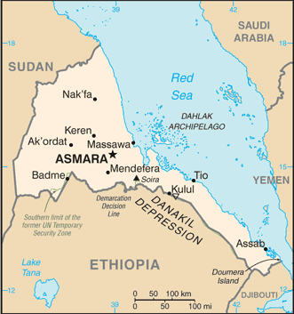
::埃塞俄比亚至少有84种不同的当地语言,高等教育和常用的通用法语为英语,许多小学的传统是使用阿姆哈拉语作为主要教学语言,但随着人口增加,其他语言的使用增加,这种语言正在瓦解。Eritrea
::厄立特里亚 厄立特里亚 厄立特里亚Map of Eritrea
::厄立特里亚地图
was an Italian colony before joining with Ethiopia in a federation in 1952. Since declaring independence in 1993, Eritrea has had a difficult time balancing positive economic growth with its border dispute with Ethiopia. The border war with Ethiopia drained this small, poor country of economic resources and destroyed valuable infrastructure. The agrarian culture and economic activities common in Africa also exists in Eritrea. Farming and raising livestock are the main activities of as much as 80 percent of its citizens.
::自1993年宣布独立以来,厄立特里亚经历了一段艰难的时期,既平衡了经济的正增长,又平衡了与埃塞俄比亚的边界争端;与埃塞俄比亚的边界战争耗尽了这个贫穷的小国的经济资源,摧毁了宝贵的基础设施;在非洲常见的农业文化和经济活动也存在于厄立特里亚;耕作和饲养牲畜是该国多达80%的公民的主要活动。The government has controlled almost every aspect of business and industry within its command economy structure. In 2008, in an attempt to attract business and connect with global markets, the port city of Massawa opened a free-trade zone and has been attracting business connections. Mineral extraction is being explored by multinational corporations, and various foreign governments have been working to establish stronger ties.
::2008年,为了吸引商业和与全球市场连接,马萨瓦港市开放了一个自由贸易区,并一直在吸引商业联系。 多国公司正在探索矿物开采,各外国政府也在努力建立更牢固的联系。Eritrea is located north of the African Transition Zone. Most countries north of the African Transition Zone have an Islamic majority, but that is not necessarily the case in Eritrea. Statistical data are difficult to confirm, but Christianity is believed to be as prominent as Islam in Eritrea. The main Christian denomination is the Eritrean Orthodox Church, with smaller percentages of Roman Catholics and Protestants. Most Muslims are Sunni.
::厄立特里亚位于非洲过渡区以北,非洲过渡区以北的大多数国家都以伊斯兰为主,但厄立特里亚的情况不一定如此。统计数据很难确认,但相信基督教与厄立特里亚的伊斯兰教一样突出。主要的基督教派别是厄立特里亚东正教,罗马天主教徒和新教教徒的比例较低。多数穆斯林是逊尼派。The government highly regulates religious activities and requires all churches to register with the state and provide personal information regarding its members. Members of religious groups not registered with the state may be subject to arrest or imprisonment for violation of this requirement. Examples of groups not approved by the government of Eritrea as of 2010 include Baha’is and Jehovah’s Witnesses.
::政府高度管制宗教活动,要求所有教会向国家登记,并提供关于其成员的个人信息。 未在国家登记的宗教团体成员可能因违反这一要求而遭到逮捕或监禁。 2010年厄立特里亚政府未批准的团体包括巴哈派教徒和耶和华见证会。Djibouti
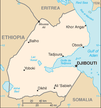
::吉布提 吉布提
Map of Djibouti
::吉布提地图
The Bab el-Mandeb Strait, between the Red Sea and the Arabian Sea, separates Africa from Asia on the southwestern tip of the Arabian Peninsula. The strait is a narrow strategic choke point for international shipping transferring cargo from Europe to Asia through the Red Sea and the Suez Canal. On the African side of the strait is the small former French colony of the Republic of .
::红海与阿拉伯海之间的巴布曼德海峡将非洲与亚洲隔开,位于阿拉伯半岛西南端,海峡是经由红海和苏伊士运河从欧洲向亚洲转运货物的国际航运的一个狭窄的战略瓶颈点,在海峡的非洲一侧是前法国殖民地。Natural resources within the country are sparse, and the republic depends on its relationship with countries such as the United States or its former colonizer to augment its financial status, keep the region stable, and protect valuable shipping in the nearby waterways. The United States has an important military base in Djibouti, which is the only major US military base in Sub-Saharan Africa. The French also have a major military base located in Djibouti.
::吉布提的自然资源稀少,共和国依靠与美国或其前殖民者等国家的关系来增加其财政地位,保持该地区稳定,保护附近水道的重要航运。 美国在吉布提拥有重要的军事基地,这是美国在撒哈拉以南非洲唯一的主要军事基地。 法国在吉布提也拥有一个重要的军事基地。The significance of the Djibouti’s location means it is a critical place for monitoring both the war on terrorism and incidences of piracy off the Horn of Africa. A main objective of having European and US military bases in Djibouti is to ensure safe passage of oil tankers through the strait providing European countries and the United States with petroleum from the Persian Gulf states.
::吉布提位置的重要性意味着它是监测反恐战争和非洲之角附近海盗事件的关键场所。 欧洲和美国在吉布提建立军事基地的主要目的是确保油轮安全通过为欧洲国家和美国提供波斯湾国家石油的海峡。Like many other African countries transitioning from colonies to independent countries, Djibouti has experienced political infighting that has been detrimental to the country’s economic situation. The government struggles with foreign debt and a lack of economic development opportunities. Most of the population lives in the capital city of Djibouti, where the unemployment rate is extremely high. Its vital location is the country’s main asset, and foreign aid has been a major part of the country’s economic equation.
::与从殖民地向独立国家过渡的其他许多非洲国家一样,吉布提经历了不利于该国经济形势的政治内斗。 政府面对外债和缺乏经济发展机会而挣扎。 大部分人口居住在吉布提首都,那里的失业率极高。 吉布提的重要位置是该国的主要资产,外援是该国经济平衡的主要部分。Somalia
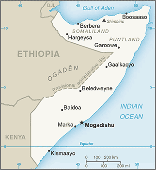
::索马里 索马里
Map of Somalia
::索马里地图
The country presently called resisted the forces of European colonizers scrambling for African land in the 1800's. The various kingdoms and their powerful leaders kept the colonial forces out well beyond World War I. Somalia’s close vicinity to the Arabian Peninsula and the prevalence of Arab trade provided a direct connection through which Islam was quickly diffused from Arabia to Africa. Political alliances were fused between the Somalian kingdoms and the Ottoman Empire. The leaders of the Horn of Africa used Islam as a centripetal force in uniting the people against outside forces.
::欧洲殖民者在1800年代争夺非洲土地的欧洲殖民者势力目前被称为“抵抗国 ” 。 各种王国及其强国领导人在第一次世界大战之后将殖民势力维持在远不止于第一次世界大战。 索马里与阿拉伯半岛的近邻和阿拉伯贸易的盛行提供了直接的联系,使伊斯兰从阿拉伯迅速扩散到非洲。 政治联盟由索马里王国和奥托曼帝国联合起来。 非洲之角领导人利用伊斯兰教作为将人民团结起来对抗外部势力的骨干力量。It was not until 1920, as a direct result of the use of airplanes in warfare, that the northern region of Somaliland buckled under to the British colonial forces. The eastern and southern regions were soon dominated by Italy. Britain finally withdrew from British Somaliland in 1960. The country then joined with the Italian portions of the region to form a new nation, Somalia.
::直到1920年,直接由于在战争中使用飞机,索马里兰北部地区才被英国殖民部队控制,东部和南部地区很快由意大利控制,英国终于于1960年撤出了英属索马里兰,然后该国与该地区意大利部分一起组成一个新国家索马里。An authoritarian socialist regime established power in 1969 and lasted until 1991. The socialist regime in Somalia initiated a territorial war in 1978 in an attempt to gain back territory in the eastern parts of Ethiopia’s Ogaden region, which was once part of the various Somalian kingdoms. The war only intensified the divisions in the region. After 1991, the country descended into political chaos, economic turmoil, and factional fighting.
::索马里社会主义政权于1978年发动了一场领土战争,企图夺回曾经是索马里各王国一部分的埃塞俄比亚欧加登地区东部的领土。 战争只会加剧该地区的分裂。 1991年之后,索马里陷入政治混乱、经济动荡和派系战斗。Northern clans who opposed the central government broke away in a move toward independence, and the old British Somaliland became the Republic of Somaliland in 1991. Somaliland operates independently from the rest of Somalia and prints its own currency. The northeast region of the country referred to as Puntland also broke away from the central government. Somaliland sought total independence, while Puntland was in favor of belonging to a national union but wanted to maintain autonomy.
::反对中央政府的北方部族在走向独立的过程中解体,旧的英属索马里兰于1991年成为索马里兰共和国。 索马里兰独立于索马里其他地区独立运作,并印出自己的货币。 被称为邦特兰的该国东北部地区也脱离中央政府。 索马里兰寻求完全独立,而邦特兰则赞成加入一个民族联盟,但希望保持自治。Both autonomous regions have their own governments and are relatively stable, but they have had conflicts regarding the territory between them. Neither is recognized by outside entities as independent countries. Puntland’s port of Bosaso has developed into a rapidly growing economic city and has expanded from 50,000 to more than 500,000 people since the year 2000. Plans are in the works for a new airport and an economic free-trade zone, which should attract additional business and an influx of additional immigrants from other parts of Somalia and the region.
::两个自治区都有自己的政府,而且相对稳定,但是它们之间在领土问题上有冲突,外部实体也没有承认它们为独立国家,邦特兰的博萨索港已发展成为一个迅速增长的经济城市,自2000年以来已经从50 000人增加到500 000人以上。 计划建造一个新的机场和经济自由贸易区,这将吸引更多的生意和来自索马里其他地区和该区域的更多移民涌入。Southern Somalia has been broken down into regions ruled by warlords who have pillaged the country and control vital transportation links. A total government breakdown occurred in 1991, leading to a meltdown in all areas of society. Food distribution was hampered through pillaging and a lack of fuel and structured transportation. Electrical power was lost and clan warfare became the rule of law.
::索马里南部已分为由军阀统治的地区,军阀掠夺国家和控制重要的交通联系,1991年政府全面崩溃,导致社会所有地区崩溃,粮食分配因抢劫和缺乏燃料及结构化运输而受到阻碍,电力丧失,部族战争成为法治。A famine subsequently caused an estimated 300,000 deaths. The United Nations (UN) stepped in with food and peacekeeping troops. In 1992, the United States dispatched marines in , which stabilized the distribution of food but was unsuccessful in stabilizing the political situation and establishing a legitimate government. In 1993, 19 US soldiers were killed in a battle in the capital, Mogadishu, after of which the US withdrew its troops. The UN withdrew its peacekeeping troops in 1995.
::1992年,美国派遣了海军陆战队,稳定了粮食分配,但在稳定政治局势和成立合法政府方面没有成功。 1993年,19名美国士兵在首都摩加迪沙的战斗中丧生,此后美国撤出了部队。 1995年,联合国撤出了维和部队。US Army soldiers coming down a street in Kismayo, Somalia. The US Army uses a M998 High-Mobility Multipurpose Wheeled Vehicle (HMMWV) to broadcast messages to the Somali locals that line the street on both sides. This mission is in direct support of Operation Restore Hope.
::索马里基斯马尤(Kismayo)的一条街上出现了美军士兵。 美军使用M998型高流动性多功能轮式机动车(MMMWV)向两边街道上线的索马里当地人播送信息。 此次任务直接支持“恢复希望行动 ” 。
Despite a lack of effective national governance, the informal economy in Somalia continues to thrive. Trading through personal transactions and the private marketplace continues to provide for the needs of the people. The main sources of revenue are agricultural goods and livestock, as well as money sent by people from outside the country to their families in Somalia.
::尽管缺乏有效的国家治理,但索马里的非正规经济继续蓬勃发展,通过个人交易和私人市场进行的贸易继续满足人民的需要,主要收入来源是农产品和牲畜,以及国外人民寄给索马里家庭的钱财。Banking and businesses have struggled to adapt to the continual conflicts, yet various hotels and service agencies continue to operate under the protection of private security militias. Telecommunication firms continue to offer service with low calling rates for urban areas.
::银行和企业努力适应持续冲突,但各种旅馆和服务机构继续在私营保安民兵的保护下运作,电信公司继续为城市地区提供低收费的服务。The educational system is heavily supported by the private sector because of the collapse of the central government. Secondary education at the university level is struggling in the south but is more established in Puntland and Somaliland, where they are funded by central authorities.
::由于中央政府的崩溃,教育系统得到了私营部门的大力支持,大学一级的中等教育在南部举步维艰,但在邦特兰和索马里兰则较为稳固,由中央当局提供资金。Income from piracy on the high seas has brought in millions to the private warlords that manage the operations. Stabilizing the country and showing economic progress will remain a difficult task for whoever leads Somalia.
::公海海盗所得收入使管理这些行动的私人军阀增加了数百万人,稳定国家并显示经济进展仍将是领导索马里的任何人的一项艰巨任务。The Rural-to-Urban Shift
::农村向城市的转变The average family size in East Africa is about 5.5, which is typical of the entire continent of Africa and translates into exploding population growth. In many areas of Africa in general and East Africa in particular, most of the population (as much as 80 percent) makes its living off the land in agricultural pursuits. Large families in rural areas create the conditions for the highest levels of rural-to-urban shift of any continent in the world.
::东非的平均家庭规模约为5.5个左右,这是整个非洲大陆的典型特征,并转化为人口的急剧增长;在非洲许多地区,特别是东非,大多数人口(高达80%)靠土地为农业目的生活;农村地区的大家庭为世界上任何大陆最高的农村向城市的转变创造了条件。The large cities—with expanding business operations complete with communication and transportation systems that link up with global activities—are an attractive draw for people seeking greater employment opportunities. In East Africa, each of the three largest cities—Nairobi, Dar es Salaam, and Addis Ababa—is more populous than Chicago, the third largest US city. In West Africa, the city of Lagos, Nigeria, is more populous than New York City and Chicago combined. These cities are all riding the worldwide wave of globalization and are core centers of economic activity for the business sector and corporate enterprises.
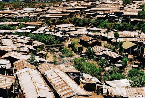
::在东非,三个最大的城市——内罗毕、达累斯萨拉姆和亚的斯亚贝巴——每个都比美国第三大城市芝加哥的人口多,在西非,尼日利亚拉各斯市的人口比纽约市和芝加哥加在一起的人口多,这些城市都在全球化世界浪潮中,是商业部门和企业经济活动的核心中心。Slum Kibera in Nairobi, Kenya.
::肯尼亚内罗毕贫民窟Kibera。
The other regions of Africa all have central cities that act as economic core areas and attract the multitudes from rural areas looking for employment and opportunities. International connections are indicative of local economic development, which is causing the urban areas to grow at exponential rates. Cities heavily affected by a high level of rural-to-urban shift often cannot build infrastructure fast enough to keep up with demand.
::非洲其他区域都拥有中央城市,这些城市作为经济核心地区,吸引了农村地区寻求就业和机会的众多人口,国际联系表明地方经济发展正在以指数速率增长,导致城市地区以指数速率增长,受到农村向城市的高度转变严重影响的城市往往无法快速建设满足需求的基础设施。Self-constructed slums and squatter settlements, which lack basic public services such as electricity, sewage disposal, running water, or transportation systems, circle the cities. All the large cities of Africa are expanding at unsustainable rates. Traffic congestion, trash buildup, high crime rates, health problems, and air pollution are some of the common results.
::缺乏电力、污水处理、自来水或交通系统等基本公共服务的自建贫民窟和棚户区环绕着城市。 非洲所有大城市都在以不可持续的速度扩张。 交通堵塞、垃圾堆积、高犯罪率、健康问题和空气污染是一些共同的结果。In the next few decades, Africa could witness the growth of megacities that might continue to expand and grow for another century. For example, if the current rates continue, Ethiopia’s population of over 105 million people in 2017 (estimate) will most likely double by 2040. Urban areas will continue to be target destinations for employment opportunities, and rural-to-urban shift will drive the populations of cities such as Addis Ababa to double, triple, or quadruple in size by 2020.
::在未来几十年里,非洲可能目睹超大城市的增长,这些城市可能会继续扩大和增长到另一个世纪。 比如,如果目前的增长率继续下去,2017年埃塞俄比亚人口超过1.05亿(估计 ) , 很可能到2040年翻一番。 城市地区将继续成为就业机会的目标目的地,而农村向城市的转变将推动亚的斯亚贝巴等城市的人口到2020年翻一番、三倍或四倍。
Key Takeaways
::密钥外出-
The physical geography of East Africa is dominated by the Great Rift Valley, which extends through the middle of the region from north to south.
::东非的实际地理以大裂谷为主,大裂谷从北向南延伸至该区域中部。 -
Associated with the rift valleys are vast savannas such as the Serengeti Plain, large lakes, high mountains, and the highlands of Ethiopia.
::与裂谷相连的是巨大的热带草原,如塞伦盖蒂平原、大湖、高山和埃塞俄比亚高原。 -
East Africa has extensive habitat for large herds of big game animals, mountains for great apes, and enough prey for the big cats such as lions and cheetahs.
::东非拥有大量大型狩猎动物群的栖息地、大型猿群的山峰,以及狮子和猎豹等大型猫群的足够猎物。 -
Countries are establishing game preserves, national parks, and conservation areas to protect these animals and their natural habitats and to provide economic opportunities to gain wealth through tourism.
::各国正在建立狩猎保护区、国家公园和保护区,以保护这些动物及其自然栖息地,并提供经济机会,通过旅游业获取财富。 -
Most of the populations of countries in East Africa earn their livelihood through agricultural activities because the region has a high percentage of people living in rural areas.
::东非国家的大部分人口通过农业活动谋生,因为该区域农村人口比例很高。 -
Large families fuel an ever-increasing rural-to-urban shift in the population, causing the cities to grow at an unprecedented rate.
::大家庭促使农村人口向城市的转移不断增加,导致城市以前所未有的速度增长。 -
Areas along the African Transition Zone have experienced a higher degree of political conflict and civil unrest.
::非洲过渡区沿线地区的政治冲突和内乱程度较高。 -
Somalia has the highest level of political division and fragmentation based on religion and ethnic backgrounds, which contributed to the secession of the two autonomous regions of Somaliland and Puntland. The central government is neither stable nor strong enough to govern the fragmented country.
::索马里的政治分裂和分裂程度以宗教和族裔背景为基础,是索马里最高水平,造成索马里兰和邦特兰两个自治区分离的原因,中央政府既不稳定,又不够强大,不足以治理这个支离破碎的国家。 -
Diversity in the region is remarkably high; there are hundreds of different indigenous ethnic groups, each with its own language and culture.
::该区域的多样性非常高;有数百个不同的土著族裔群体,每个群体都有自己的语言和文化。 -
Religious activity is divided amongst Christianity, Islam, and traditional beliefs.
::宗教活动分为基督教、伊斯兰教和传统信仰。 -
Islam is more favored in the African Transition Zone and to the north, while Christianity and animism are more prominent to the south of the zone.
::伊斯兰教在非洲过渡区和北部更受青睐,而基督教和无动于衷主义则在该区南部更为突出。
Vocabulary Terms
::词汇术语术语Chapter 8.6 East Africa
::第8.6章 东非Aksum
::Assum 重算East African trading kingdom along the Red Sea today known as Ethiopia which grew wealthy from trade. L ocated on the R ed S ea
::今天,沿红海沿红海的东非贸易王国被称为埃塞俄比亚,它从贸易中发富。Ma a sai
::马赛East African ethnic group that lives on the grasslands of the rift valleys in Kenya and Tanzania
::生活在肯尼亚和坦桑尼亚裂谷草原上的东非族裔群体Olduvai Gorge
::奥尔杜瓦伊峡谷a gorge in northeastern Tanzania where anthropologists have found some of the earliest human remains
::在坦桑尼亚东北部的一个峡谷 那里的人类学家发现了一些最早的遗骸Serengeti Plain
::塞伦盖蒂平原An area in East Africa containing some of the best grasslands in the world along with unique grazing animals
::东非的一个地区含有世界上一些最好的草原以及独特的放牧动物。Applying Knowledge
::应用知识Interactive Notebook Activity
::交互式笔记活动-
Find out what the news media is reporting regarding current events and political stability in Somalia.
::调查新闻媒体报导索马里当前事件及政治稳定情况。 -
Research the endangered status of mountain gorillas in East Africa.
::研究东非山地大猩猩濒危状况。
Discussion and Study Questions
::讨论和研究问题-
Where do the White Nile and the Blue Nile begin? Where do they converge?
::白尼罗河和青尼罗河从哪里开始? -
What is the Great Rift Valley? How is the Western Rift different from the Eastern Rift?
::大裂谷是什么?西裂谷与东裂谷有何不同? -
What has been found at Olduvai Gorge? Why is this significant?
::在奥杜威峡谷发现了什么? -
How have Kenya and Tanzania attempted to preserve and protect the environment?
::肯尼亚和坦桑尼亚是如何试图保护和保护环境的? -
Where is the Serengeti Plain? How does it bring national wealth to its home countries?
::塞伦盖蒂平原在哪里?它如何将国家财富带回祖国? -
What are the main religions in Ethiopia, Eritrea, and Somalia? How did belief systems diffuse to Ethiopia, Eritrea, and Somalia? What regions did they diffuse from?
::埃塞俄比亚、厄立特里亚和索马里的主要宗教是什么?信仰体系是如何向埃塞俄比亚、厄立特里亚和索马里传播的?信仰体系是从哪些地区传播的? -
What is Tanzania’s lingua franca? How is this different from other African countries?
::坦桑尼亚的通用语是什么? 这与其他非洲国家有什么不同? -
What are the main political regions of Somalia? How does Somalia’s central government function?
::索马里的主要政治区域是什么?索马里中央政府如何运作? -
What is Djibouti’s main asset? Why would the United States or France want to control Djibouti?
::吉布提的主要资产是什么? 为什么美国或法国要控制吉布提? -
What two main factors cause a high level of rural-to-urban shift?
::哪些两个主要因素导致农村向城市的高度转变?
Real-World Geography Exercise
::现实世界地理演习Using , locate each one of the places below. Next, choose one location that is interesting to you and create a SWAY or a PowerPoint presentation. Include important facts, images, maps, and videos. Be prepared to share your presentation.
::使用 , 定位下面每个位置。 接下来, 选择一个您感兴趣的位置, 创建一个 SWAY 或 PowerPoint 演示文稿 。 包含重要的事实、 图像、 地图和视频 。 准备分享您的演示文稿 。-
Bab el-Mandeb Strait
::巴布曼德海峡 -
Blue Nile
::青青尼罗州 -
Bosaso
::波萨索 -
Dar es Salaam
::达累斯萨拉姆 -
Eastern Rift Valley
::东裂谷 -
Ethiopian Plateau
::埃塞俄比亚高原 -
Great Rift Valley
::大裂谷 -
Lake Albert
::阿尔贝湖 -
Lake Edward
::爱德华湖 -
Lake Tana
::塔纳湖 -
Lake Turkana
::特库卡纳湖 -
Lake Victoria
::维多利亚湖 -
Mombassa
::蒙巴萨 -
Mt. Kenya
::Mt. 肯尼亚 -
Mt. Kilimanjaro
::乞力马扎罗山 -
Nile River
::尼罗河 -
Ol Doinyo Lengai
::达尼约·伦盖 -
Olduvai Gorge
::奥尔杜瓦伊峡谷 -
Puntland
::邦特兰 -
Rwenzori Mountains
::鲁文佐里山脉 -
Serengeti Plain
::塞伦盖蒂平原 -
Somaliland
::索马里兰 -
Virunga Mountains
::维龙加山脉 -
Western Rift Valley
::西裂谷 -
White Nile
::白尼罗河 -
Zanzibar
::桑给巴尔
Current Events
::当前事件Geography Education Scoop It
::地理教育中心Videos for Geography Enrichment
::地理丰富视频Helpful Websites for the Study of Geography
::地理研究有用网站is an encyclopedia funded by the Canadian government covering all branches of knowledge. Their scholarly collection includes interactive materials.
::该百科全书由加拿大政府资助,涵盖所有知识分支,其学术收藏包括交互式材料。provides information on the people, history, government, economy, energy, geography, communications, transportation, military, and transnational issues for the world's entities.
::向世界各实体提供关于人民、历史、政府、经济、能源、地理、通信、运输、军事和跨国问题的资料。is a US government website where you can find federal legislation, past and present, as well as information about the US legal system.
::是一个美国政府的网站,您可以在此找到过去和现在的联邦立法以及关于美国法律制度的信息。is a government agency website that provides current news, resources, topics of interest, information about drugs, careers in the DEA, and a tip hotline.
::是一个政府机构网站,提供最新消息、资源、感兴趣的话题、毒品信息、在缉毒局的职业以及一条小费热线。is the largest library in the world and provides manuscripts, files, information, pictures, and videos.
::图书馆是世界上最大的图书馆,提供手稿、文件、信息、图片和录像。is a US government agency website that allows users to search for and retrieve satellite images of Earth.
::这是一个美国政府机构的网站,用户可以搜索和检索地球的卫星图像。is a US government website that provides historical documents, photos, records, publications, and educator resources.
::这是一个美国政府网站,提供历史文件、照片、记录、出版物和教育资源。is a US government agency website that provides weather-related information and ocean research.
::是一个提供气象信息和海洋研究的美国政府机构网站。is a website by the United States Geological Survey and other federal, state, and local agencies that delivers topographic information for the United States.
::这是美国地质调查局和其他联邦、州和地方机构为美国提供地形信息的网站。is a massive central data source and a handy way to graphically compare nations.
::是一个庞大的中央数据源,是用图形比较国家的一种方便方式。is a website that measures most locations in the world for air pollution in real time.
::是一个实时测量世界上大多数空气污染地点的网站。is a unique statistical database, which allows you to research and compare a multitude of different data on US states.
::这是一个独特的统计数据库, 使你能够研究和比较关于美国各州的多种不同数据。is an international organization founded in 1945 and made up of 193 member states. The UN maintains international peace and security, protects human rights, delivers humanitarian aid, promotes sustainable development, and upholds international law.
::联合国是一个国际组织,成立于1945年,由193个成员国组成。 联合国维护国际和平与安全,保护人权,提供人道主义援助,促进可持续发展,维护国际法。is a US government agency that provides a population clock, data, surveys, statistics, a library with information and infographics, news about the economy, and much more.
::这是一个美国政府机构,它提供人口钟、数据、调查、统计、一个拥有信息和信息资料的图书馆、关于经济的新闻,以及更多。is a US government agency website that provides scientific information about the natural hazards that threaten lives, the natural resources we rely on, the health of our ecosystems and environment, and the impacts of climate and land-use change.
::这是一个美国政府机构的网站,提供科学信息,说明威胁生命的自然危害、我们赖以生存的自然资源、生态系统和环境的健康以及气候和土地使用变化的影响。is a US government website that provides the latest presidential news, information about the budget, policy, defense, and many more topics.
::提供最新总统新闻、预算、政策、国防等资讯, 以及更多议题。is under the United Nations and provides leadership on matters critical to health, shapes the research agenda on health, and monitors the health situation and assessing health trends around the world. Their website provides information on the state of health around the world, outbreaks, current health news, and more.
::网站提供世界各地卫生状况、疫情爆发、最新卫生新闻等信息。is an intergovernmental organization that regulates international trade. The website provides information on the history of the multilateral trading system, featured videos, news and events, trade topics, and more.
::该网站提供关于多边贸易体系历史的信息、视频、新闻和事件、贸易专题等等。 -
Summarize the physical layout and features of East Africa, including the Great Rift Valley.