2.1地球表面简介
章节大纲
-
Lesson Objectives
::经验教训目标- Describe how you can find a location and direction on Earth's surface.
::描述您如何在地球表面找到位置和方向。
- Describe topography.
::描述地形。
- Identify various landforms and briefly describe how they form.
::查明各种土地形式,并简要说明其形成方式。
Lesson Vocabulary
::词汇表课程- compass
::指南针
- compass rose
::指南针上升
- constructive forces
::建 建 建 建 建 建 建 建 建 建 建 建 建 建 建 力
- continent
::大陆大陆
- destructive forces
::破坏力
- elevation
::高高
- topography
::地形地形
Introduction
::导言Beautiful mountain ranges, deep canyons, flat plains. You can see all these features on Earth's surface. Beneath the sea are similar features. Only a few people have actually seen them directly. Some scientists study life on Earth. Some study outer space. Some scientists learn about Earth's surface. Earth is our home. We need to learn as much as possible about it. We need to study Earth's structures. There are many questions that need to be answered. Why are some mountains taller than others? Why are there volcanoes on the ocean floor? Why are some mountain chains on the edges of continents? Knowing the answers to these questions can give us clues to Earth's past and future. As you recall, scientist need to share what they learn. To do so, they must also be able to explain a feature's location.
::美丽的山脉, 深峡谷, 平原。 你可以看到地球表面的所有这些特征。 海底是相似的特征。 只有少数人真的直接看到了这些特征。 一些科学家研究地球上的生命。 一些科学家研究地球生命; 一些研究外层空间。 一些科学家学习地球表面。 一些科学家学习地球表面。 地球是我们的家。 我们需要尽可能多地学习地球结构。 我们需要研究地球结构。 有许多问题需要解答。 为什么有些山脉比其它山脉高? 为什么洋底有火山? 为什么大陆边缘有山链? 为什么大陆边缘有一些山链? 了解这些问题的答案可以给我们提供地球过去和未来的线索。 正如你所记得的那样, 科学家需要分享他们学到的东西。 要做到这一点, 他们还必须能够解释地貌的位置。Location
::地点地点地点地点地点How can you describe your location? You might use a familiar system. You might say, "I live at 1234 Main Street, Springfield, Ohio." You could also say, "I live right behind the Elementary School." This method uses the school as a point of reference. Another example is, “I am at the corner of Maple Street and Main Street." Both streets may be a good reference for anyone living in your town.
::你如何描述你的位置?你可以使用一个熟悉的系统。你可以说,“我住在俄亥俄州斯普林菲尔德市1234号主街。”你也可以说,“我住在小学后面。”这个方法把学校作为参照点,另一个例子是“我在马普勒街和梅普林街的拐角。”两条街都可能是你们镇上任何居民的好参考。Scientists must be able to pinpoint a feature they are studying. Scientists use a special system to describe locations. They use latitude and longitude as a reference. Lines of latitude and longitude form a grid. You may have used a grid system while doing graphing. This grid is centered on a reference point. Zero latitude is the equator. Lines of latitude run east to west. They divide the Earth from North to South. Lines of longitude run from north to south. They divide the Earth from East to West. Zero longitude runs through Greenwich, England. You may have heard the term, Greenwich Mean Time, or GMT.
::科学家必须能够确定他们正在研究的特征。 科学家们使用一种特殊的系统来描述位置。 他们使用纬度和经度作为参照。 纬度和经度的线形成一个网格。 您在绘制图表时可能使用了网格系统。 这个网格位于一个基准点上。 零纬度是赤道。 纬度向东向西, 将地球从北向南分隔。 长线从北向南分割。 他们将地球从东向西分割。 零经线穿过英国格林威治。 您可能听说过格林威治时间或格林威治时间 。The system of latitude and longitude works well for objects that do not move. Some things we study on Earth are in motion. How can we describe an object that is in motion?
::纬度和经度系统对不移动的物体运作良好。 一些我们在地球上研究的东西正在移动。 我们如何描述一个在移动的物体?Direction
::方向方向方向方向方向方向方向方向方向方向方向方向方向方向方向方向方向方向方向方向方向方向方向方向方向方向方向方向方向方向方向方向方向方向方向方向方向方向方向方向方向方向方向方向方向方向方向方向方向方向方向方向方向方向方向方向方向方向方向方向方向方向方向方向方向方向方向方向方向方向方向方向方向方向方向方向方向方向方向方向方向方向方向方向方向方向方向方向方向方向方向方向方向方向方向方向方向方向方向方向方向方向方向方向方向方向方向方向方向方向方向方向方向方向方向方向方向方向方向方向方向方向方向方向方向方向方向方向方向方向方向方向方向方向方向方向方向方向方向方向方向方向方向方向方向方向方向方向方向方向方向方向方向方向方向方向方向方向方向方向方向方向方向方向方向方向方向方向方向方向方向方向方向方向方向方向方向方向方向方向方向方向方向方向方向方向方向方向方向方向方向方向方向方向方向方向方向方向方向方向方向方向方向方向方向方向方向方向方向方向方向方向方向方向方向方向方向方向方向方向方向方向方向方向方向方向方向方向方向方向方向方向方向方向方向方向方向方向方向方向方向方向方向方向方向方向方向方向方向方向方向方向方向方向方向方向方向方向方向方向方向方向方向方向方向方向方向方向方向方向方向方向方向方向方向方向方向方向方向方向方向方向方向方向方向方向方向方向方向方向方向方向方向方向方向方向方向方向方向方向方向方向方向方向方向方向方向方向方向方向方向方向方向方向方向方向方向方向方向方向方向方向方向方向方向方向方向方向方向方向方向方向方向方向方向方向方向方向方向方向方向方向方向方向方向方向方向方向方向方向方向方向方向方向方向方向方向方向方向方向方向方向方向方向方向方向方向方向方向方向方向方向方向方向方向方向方向方向方向方向方向方向方向方向方向方向方向方向方向方向方向方向方向方向方向方向方向方向方向方向方向方向方向方向方向方向方向方向方向方向方向方向方向方向方向方向方向方向方向方向方向方向方向方向方向方向方向方向方向方向方向方向方向方向方向方向方向方向方向方向方向方向方向方向方向方向方向方向方向方向方向方向方向方向方向方向方向方向方向方向方向方向方向方向方向方向方向方向方向方向方向方向方向方向方向方向方向方向方向方向方向方向方向方向方向方向方向方向方向方向方向方向方向方向方向方向方向方向方向方向方向方向方向方向方向方向方向方向方向It is not enough to describe some objects by their location. We may also need to know its direction. For example, a wind blows a storm over your school. Where is that storm coming from? Where is it going?
::光按位置描述一些物体是不够的, 我们还需要知道它们的方向。 例如, 风吹到你的学校上。 暴风从哪来? 它往哪去?How can we describe a direction? The most common way is by using a compass . A compass is a device with a floating needle ( Figure ). The needle is a small magnet. The needle aligns itself with the Earth's magnetic field. The compass needle always points to magnetic north. If you have a compass and you find north. You can then know any other direction. See the directions, such as east, south, west, etc., on a compass rose .
::如何描述方向? 最常用的方法是使用指南针。 指南针是带有浮动针的装置( 图表 ) 。 针是小磁铁 。 针与地球磁场一致。 指南针总是指向磁性北面。 如果您有指南针, 找到北面, 您可以知道任何其他方向 。 请在指南针上看到方向, 如东、 南、 西等 。(A) A compass is a device that is used to determine direction. The needle points to Earth's magnetic north pole. (B) A compass rose shows the four major directions. It may also show intermediate directions between them. The Earth has two poles. It has a magnetic north pole. It also has a geographic north pole. These two poles are close to each other but not the exact same place. The geographic north pole runs through the Earth's axis. It is on this imaginary axis that the Earth rotates. The geographic north pole is much like the spindle of a spinning top. The location of this pole does not change. However, the magnetic north pole does move over time. Compass users will need to correct for the difference in the two poles ( Figure ).
::地球有两个极。 它有一个磁性北极。 它有一个地理上的北极。 这两个极彼此相近, 但不是完全相同的地方。 地理上的北极穿过地球轴。 地球就是在这个虚构的轴上旋转。 地理上的北极与旋转的顶部的螺旋一样。 这个极的位置没有变化。 但是, 磁性北极确实会随时间而移动。 指南用户需要纠正两个极的差别( Figure ) 。Earth's magnetic north pole is about 11 degrees offset from its geographic north pole. Some maps have a double compass rose. It will show both magnetic and geographic north. This allows users to make the corrections. An example is a nautical chart that boaters use. They use it to keep track of their positions at sea ( Figure ).
::有些地图有双罗盘玫瑰, 它将显示磁性和地理性的北向。 这样用户就可以进行校正。 例如, 航海者们使用的海图, 他们用它来跟踪他们在海上的方位( 图 ) 。Nautical maps include a double compass rose that shows both magnetic directions (inner circle) and geographic compass directions (outer circle). Topography
::地形As you know, the surface of Earth is not flat. Some places have very high mountains. Other places have very deep canyons and valleys. For example, mountain ranges may be high above the surrounding areas. How can we describe a region's topography?
::正如你们所知,地球表面不是平坦的,有些地方有很高的山峰,另一些地方有非常深的峡谷和山谷。例如,山脉可能高过周围地区。我们如何描述一个区域的地形?To describe it we need two things. First, we need to know how high or low it is. Then, we need to know how it compares to sea level. You might measure your height relative to your classmates. When your class lines up, some kids make high “mountains.” Other students are more like small hills! Height is measured from the top of your head to the floor.
::要描述它,我们需要两样东西。 首先,我们需要知道它有多高或低。 然后,我们需要知道它与海平面的对比程度。 你也许可以比同学衡量你的身高。 当你的班级排队时,有些孩子会做高的“山顶 ” 。 其他学生更像小山丘。 从头顶到地板,高度是测量的。Continents and Landforms
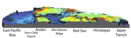
::大陆和陆地形态What if you could drain all of Earth's oceans ( Figure )? What would it look like? You might be really surprised. You see that the surface has two main features. It has continents and ocean basins. Continents are large land areas. These are the areas that are mostly above sea level. Ocean basins extend from the edges of continents. They include the ocean floor and Earth's deep ocean trenches. You will also notice the ocean floor is not flat. It too has many features similar to the continents. There are deep valleys, or trenches. There are large mountain ranges. There are also volcanoes. All of these features provide clues to Earth's geologic past and future.
::如果你能耗尽地球的所有海洋(图)呢?你会觉得怎样呢?你会觉得很惊讶吗?你看,地表有两个主要特征。它有大陆和海洋盆地。大陆是大片陆地地区。这些是大部分海平面以上的地区。海洋盆地从大陆边缘延伸而来,包括洋底和地球的深海海沟。你也会注意到洋底不是平的。它有许多与大陆相似的特征。有深谷或海沟。有巨大的山脉。还有火山。所有这些特征都为地球的地质过去和未来提供了线索。This image shows Earth with water removed. The red areas are high elevations (mountains). Yellow and green areas are lower elevations. Blue areas are the lowest on the ocean floor. Continents are much older than ocean basins. Some rocks on the continents are billions of years old. Ocean basins may only be millions of years old. Because the continents are so old, a lot has happened to them!
::大陆比海洋盆地老得多,大陆上的一些岩石有数十亿年的历史,海洋盆地可能只有几百万年的历史,因为大陆太老了,它们发生了许多事情!As we view the land around us, we see landforms. Landforms are physical features on Earth's surface. These features change over time, but how? There are actually two types of forces at work. One force builds the Earth up and the other tears it down.
::当我们观察周围的土地时,我们看到陆地形态。陆地形态是地球表面的物理特征。这些特征随着时间的推移而变化,但又是如何变化的?实际上有两种力量在起作用。一种力量将地球积聚起来,另一种力量将其撕裂掉。Constructive forces cause landforms to grow. Lava flowing into the ocean creates new land. A volcano can be a constructive force. The Islands of Hawaii are good examples of the constructive force of volcanoes.
::火山可能是一种建设性力量。夏威夷群岛是火山具有建设性力量的好例子。Destructive forces may blow landforms apart. A volcano blowing its top off is a destructive force. A volcano is a very fast change. Some changes to the Earth happen more slowly. The destructive forces of weathering and erosion change landforms more slowly. Over millions of years, mountains are worn down by erosion. The Appalachian Mountains are good examples of weathering and erosion. They were once as tall as the Rocky Mountains. They have been worn down over time.
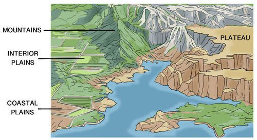
::破坏力可能会粉碎陆地形态。 火山顶部爆炸是一个破坏力。 火山是一个非常快速的变化。 火山是一个非常快速的变化。 地球的一些变化会更慢。 天气和侵蚀的破坏力会更慢地改变土地形态。 数以百万计的年月里, 山体会因侵蚀而衰败。 阿巴拉契亚山脉是天气和侵蚀的好例子。 它们曾经和落基山脉一样高。 它们被逐渐磨损。Constructive and destructive forces work together to create landforms. Constructive forces create mountains. Over time, erosion may wear them away. Mountains are very large landforms. Mountains may wear away into a high flat area called a plateau. Interior plains are in the middle of continents. Coastal plains are on the edge of a continent, where it meets the ocean.
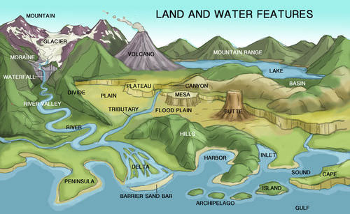
::具有建设性和破坏性的力量共同努力创造土地形态。 具有建设性的力量创造了山岳。 随着时间的推移, 侵蚀可能会使山岳消失。 山岳是巨大的土地形态。 山岳可能消失在一个称为高原的高平坦地区。 内地平原位于大陆中部, 沿海平原位于大陆边缘, 与海洋相接。Features of continents include mountain ranges, plateaus, and plains. Rivers and streams flow across continents. They cut away at rock. They may form river valleys ( Figure ). These are destructive forces. The bits and pieces of rock can be carried downstream by rivers. They are eventually deposited where rivers meet the oceans. These can form deltas, like the Mississippi River delta. They can also form barrier islands. Padre Island in Texas is an example of a barrier island. Rivers bring sand to the shore. The sand forms beaches. These are constructive forces.
::河流和溪流横跨各大洲,它们切开岩石,形成河谷(图)。这些是破坏力。岩石的碎片和碎块可以由河流承载到下游。它们最终会沉积在河流与海洋交汇的地方。它们可以形成三角洲,如密西西比河三角洲。它们也可以形成屏障岛。得克萨斯的帕德勒岛就是一座屏障岛的一个例子。河流将沙子带到岸边。沙子形成海滩。这些都是建设性的力量。Summary of major landforms on continents and features of coastlines. Ocean Basins
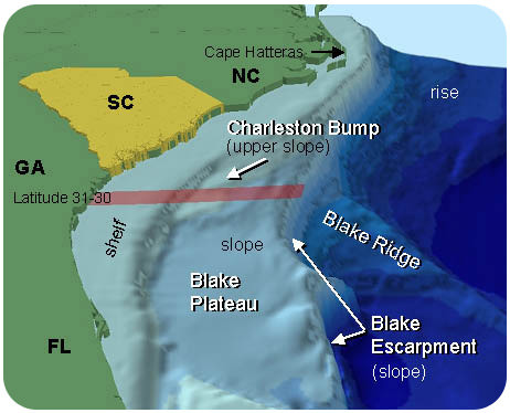
::海洋盆地The continental margin begins at the shore. It extends down to the ocean floor. It includes the continental shelf, slope, and rise. The continental shelf is part of the continent. It is about 100-200 meters deep. It is much shallower than the rest of the ocean. The continental shelf usually extends out about 100 to 200 kilometers from the shore ( Figure ).
::大陆边从海岸开始,延伸至洋底,包括大陆架、斜坡和上升,大陆架是大陆的一部分,深约100至200米,比海洋其他部分浅得多,大陆架通常从海岸延伸约100至200公里(图)。The continental shelf and slope of the southeastern United States goes down to the ocean floor. The continental slope marks the edge of the continent. This is where the ocean basins begin.
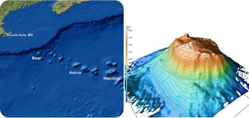
::大陆坡标志着大陆的边缘。这是海洋盆地的起点。The ocean floor is not totally flat. In many places, small hills rise above the ocean floor. These hills are undersea volcanoes, called seamounts ( Figure ). Some rise more than 1000 m above the seafloor.
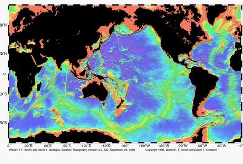
::洋底并非完全平坦,在许多地方,小山丘在洋底上方,这些山是海底火山,称为海山(图 ) 。 有些山峰在海床上方1000米以上。A chain of seamounts off the coast of New England (left). Oceanographers mapped one of these seamounts, called Bear Seamount, in great detail (right). There are also long and very tall (about 2000 m) mountain ranges. These ranges are connected. They form huge ridge systems. These ridge systems extend from ocean to ocean. These ridges usually occur at the centers of ocean basins. For this reason, they are called mid-ocean ridges ( Figure ). The mid-ocean ridges form from volcanic eruptions. Lava from inside Earth breaks through the crust. As a result, mountains are created.
::还有长而高的山脉(约2000米),这些山脉是相连的。它们形成巨大的脊脊系统。这些脊系统从海洋延伸到海洋。这些脊系统通常发生在海洋盆地的中心。因此,它们被称为中洋脊(Figore)。火山爆发形成的洋中脊。从地球内部的岩浆穿过地壳。结果,山峰被创造出来。Map of the mid-ocean ridge system (yellow-green) in Earth's oceans. You may have heard of the Grand Canyon. It is a mile wide and mile deep. That is a small scratch in Earth's surface compared to deep sea trenches.
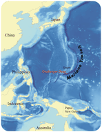
::你可能听说过大峡谷,宽一英里,深一英里,与深海战壕相比,地表上的刮痕很小。The deepest places of the ocean are the ocean trenches. Many trenches line the edges of the Pacific Ocean. The Mariana Trench is the deepest place in the ocean. ( Figure ). It is almost 11 km deep. To compare, Mt. Everest is a little less than 9 km tall. It is the tallest mountain on Earth. If placed in the trench, its peak would not reach the top of the trench.
::海洋的最深处是海沟,许多海沟是太平洋边缘的沟渠。马里亚纳海沟是海洋中最深处的地方。(图 ) 。 它的深度近11公里。 相比之下, 珠穆朗玛峰略小于9公里高, 它是地球上最高的山。 如果被安置在海沟中, 它的峰值不会到达海沟的顶端。The Mariana Trench is east of Guam in the Pacific Ocean. Lesson Summary
::经验教训摘要- Earth scientists must be able to describe exact locations of features on Earth's surface.
::地球科学家必须能够描述地球表面特征的确切位置。
- Locations often include distances and directions.
::地点往往包括距离和方向。
- A compass has a tiny magnetic needle. This needle points toward Earth's magnetic North Pole. Once you have found north, you can find east, west, and south, using your compass for reference.
::一个罗盘有一个微小的磁性针。 这个针指向地球磁性北极。 一旦你找到了北边, 你可以找到东、西和南边, 用你的罗盘作为参考。
- Topography describes how Earth's surface varies in elevation.
::地形描述地球表面在海拔上的差异。
- Constructive forces create landforms. Destructive forces wear landforms down. Together, they shape the Earth's surface.
::构造力形成陆地形态。 破坏力磨损陆地形态。 它们一起塑造了地球表面。
Lesson Review Questions
::经验回顾问题Recall
::回顾1. What information might you need to describe the location of a feature on the Earth's surface?
::1. 您需要何种信息来描述地貌特征在地球表面的位置?2. On the continents, which landforms rise the highest?
::2. 在大陆上,哪些大陆形态上升最高?3. What is topography?
::3. 什么是地形?Apply Concepts
::应用概念4. Why would you need to know direction if an object is moving?
::4. 如果物体在移动,你为什么需要知道方向?5. Why do nautical charts have two compass roses on them?
::5. 为什么海图上有两个罗盘玫瑰?Think Critically
::仔细仔细思考6. Why do you think that the ocean basins are younger than the continents?
::6. 为什么你认为海洋盆地比大陆年轻?7. Explain what landforms on the continents are created by erosion from wind and water. How does erosion create a landform?
::7. 解释一下风和水的侵蚀造成大陆上的哪些地形形态,侵蚀如何造成土地形态?Points To Consider
::需要考虑的要点- A new volcano rises in Mexico. How you would describe its position in a scientific report?
::墨西哥有一座新的火山升起。您在一份科学报告中如何描述其位置?
- Can you devise a system to show low areas and high areas on a map?
::您能否设计一个在地图上显示低地和高地的系统?
- Why do you think continents are higher areas on Earth than the ocean basins?
::为什么你认为大陆是地球上比海洋盆地更高的地区?
- Describe how you can find a location and direction on Earth's surface.