3.2 早期发展和全球化(2天)
章节大纲
-
Chapter Challenges
::章次 挑战-
Explain how the United States acquired its geographic boundaries.
::解释美国是如何获得其地理边界的。 -
List patterns of immigration to and migration within the United States through the period of westward settlement.
::向西定居期间向美国移民和在美国境内移徙的格局清单。 -
Describe urban growth and its connection to development of new forms of transportation.
::描述城市增长及其与发展新运输形式发展的联系。 -
Explain which economic patterns helped the United States become the world’s largest economy.
::解释一下哪些经济格局帮助美国成为世界最大的经济体。 -
Describe how the concept of the American Dream has been exported globally.
::描述“美国梦”的概念是如何被全球输出的。
Student Learning Objectives
::学生学习目标TEKS Regional Unit 03: United States and Canada Chapter 3.2
::TEKS 区域股03:美国和加拿大WG.5B Interpret political, economic, social, and demographic indicators (gross domestic product per capita, life expectancy, literacy, and infant mortality) to determine the level of development and standard of living in nations using the terms Human Development Index, less developed, newly industrialized, and more developed
::WG.5B 解释政治、经济、社会和人口指标(人均国内生产总值、预期寿命、识字率、识字率和婴儿死亡率),以确定使用人类发展指数、欠发达、新兴工业化和较发达等术语的国家的发展水平和生活水平WG.6A Locate and describe human and physical features that influence the size and distribution of settlements
::WG.6A 确定并描述影响定居点规模和分布的人类和自然特征WG.6B Explain the processes that have caused changes in settlement patterns, including urbanization, transportation, access to and availability of resources, and economic activities
::WG.6B 解释导致住区模式变化的进程,包括城市化、运输、获得和获得资源以及经济活动WG.9A Identify physical and/or human factors such as climate, vegetation, language, trade networks, political units, river systems, and religion that constitute a region
::WG.9A 查明构成区域的气候、植被、语言、贸易网络、政治单位、河流系统和宗教等有形和/或人为因素WG.10D Compare global trade patterns over time and examine the implications of globalization, including outsourcing and free trade zones
::WG.10D 比较随着时间推移的全球贸易格局并审查全球化的影响,包括外包和自由贸易区WG.11A Understand the connections between levels of development and economic activities (primary, secondary, tertiary, and quaternary)
::WG.11A 了解发展水平与经济活动(第一、第二、第三和第四阶段)之间的联系WG.11B Identify the factors affecting the location of different types of economic activities, including subsistence and commercial agriculture, manufacturing, and service industries
::WG.11B 查明影响各类经济活动地点的因素,包括维持生计和商业性农业、制造业和服务业WG.11C Assess how changes in climate, resources, and infrastructure (technology, transportation, and communication) affect the location and patterns of economic activities
::WG.11C 评估气候、资源和基础设施(技术、运输和通信)的变化如何影响经济活动的地点和模式WG.12A how the creation, distribution, and management of key natural resources affects the location and patterns of movement of products, money, and people
::WG.12A 关键自然资源的创造、分配和管理如何影响产品、货币和人员流动的地点和模式WG.13A Interpret maps to explain the division of land, including man-made and natural borders, into separate political units such as cities, states, or countries
::WG.13A 解释地图,解释土地划分,包括人为和自然边界,分为不同的政治单位,如城市、州或国家WG.14C Analyze current events to infer the physical and human processes that lead to the formation of boundaries and other political divisions
::WG.14C 分析当前事件,以推断导致形成边界和其他政治分裂的物质和人类过程WG.16A Describe distinctive cultural patterns and landscapes associated with different places in Texas, the United States, and other regions of the world and how these patterns influenced the processes of innovation and diffusion.
::WG.16A 描述与得克萨斯州、美国和世界其他地区不同地方有关的独特文化模式和景观,以及这些模式如何影响创新和传播进程。WG.16D Compare life in a variety of urban and rural areas in the world to evaluate political, economic, social, and environmental changes
::WG.16D 比较世界不同城市和农村地区的生活,以评价政治、经济、社会和环境变化WG.18D Evaluate the spread of cultural traits to find examples of cultural convergence and divergence such as the spread of democratic ideas, US-based fast-food franchises, the English language, technology, or global sports.
::WG.18D 评价文化特征的传播情况,以寻找文化趋同和差异的例子,例如民主思想的传播、以美国为基地的快餐专营、英语、技术或全球体育。WG.19A Evaluate the significance of major technological innovations in the areas of transportation and energy that have been used to modify the physical environment
::WG.19A 评价用于改变自然环境的运输和能源领域重大技术革新的重要性United States: Early Development and Globalization
::美国:早期发展和全球化Early Development Patterns
::早期发展模式Canada and the United States is divided into a number of physical regions with distinct landforms. The western part of the continent is marked by north-south mountain ranges in the Rocky Mountains and Pacific Mountains and Valley's physiographic provinces, with the Intermontane Basins and Plateaus in between. The eastern portion of the United States is defined by the ancient Appalachian Mountains, a mountain range that is much less rugged than the Rockies but with no less influence on the history and development of this region. The interior of North America is characterized by plains—the Interior Lowlands and the Great Plains. To the north is the Canadian Shield, geologically the oldest part of North America, and a sparsely populated area with poor soils. At the southern and eastern edge of the continent is the Atlantic Coastal Plain, a relatively flat zone that extends from New York to Texas.
::加拿大和美国分为若干地貌不同的自然区域,非洲大陆西部以洛基山脉、太平洋山脉和河谷的地貌省份的北南山脉为标志,北蒙坦河流域和高原位于中间地带,美国东部以古阿巴拉契山脉为标志,远比落基山脉更不那么崎岖,但对该地区的历史和发展影响也不小,北美内地以平原为特征,内地低地和大平原为特征,北部是加拿大盾牌,地质上是北美最古老的地区,人口稀少,土壤贫瘠,大陆南部和东部边缘是大西洋沿岸平原,从纽约延伸到得克萨斯州,相对平坦然。Manifest Destiny
::明示命运The concept of Manifest Destiny came from the works of John O’Sullivan in 1839. O’Sullivan wrote, "The far-reaching, the boundless future will be the era of American greatness. In its magnificent domain of space and time, the nation of many nations is destined to manifest to mankind the excellence of divine principles; to establish on earth the noblest temple ever dedicated to the worship of the Most High—the Sacred and the True. Its floor shall be a hemisphere—its roof the firmament of the star-studded heavens, and its congregation an Union of many Republics, comprising hundreds of happy millions, calling, owning no man master, but governed by God’s natural and moral law of equality, the law of brotherhood—of “peace and good will amongst men ” ( ).
::奥苏利万写道 : “ 影响深远、无穷无尽的未来将是美国伟大的时代。 在其巨大的空间和时间领域,许多国家的国家注定要向人类展示崇高的神圣原则;在地球上建立最尊贵的神庙,献给最尊贵的神圣和真理的神庙。 其楼层将是一个登上星空坚固的半球,其会堂将是一个由数以亿计的幸福万计的共和国组成的联盟,号召、不拥有任何主人,而是受上帝的自然和道德平等法、兄弟关系法—— " 人类之间的和平和善意 "的制约。
As the United States developed, it acquired external colonial possessions. With the victory over Spain in the , the US government gained control of the Philippines, Cuba, Puerto Rico, Guam, and various Pacific islands. and the later became independent countries, but and continue to be part of the United States. The were purchased from in 1918 after as a location to provide strategic military support to protect the shipping lanes through the Caribbean and the .
::随着美国的发展,它获得了外部殖民财产。 随着西班牙在西班牙的胜利,美国政府获得了对菲律宾、古巴、波多黎各、关岛和各个太平洋岛屿的控制权。 后者成为了独立的国家,但继续是美国的一部分。 这些财产是在1918年作为提供战略军事支持以保护通过加勒比和加勒比的航道的地点购买的。Westward Settlement Patterns and European Immigration
::西向定居模式和欧洲移民The 13 original colonies are often grouped into three regions, each with its own economic and cultural patterns. These three areas—New England, the Mid-Atlantic, and the South—are considered culture hearths, or places where culture formed and from which it spread. The three regions were source areas for westward migration, and migrants from these regions carried with them the cultural traditions of their culture hearths. The New England colonies were characterized by poor soils, subsistence agriculture, and fishing communities. They were also the birthplace of North America’s Industrial Revolution. Boston was the largest city in the region.
::13个原始殖民地往往分为三个区域,每个区域都有自己的经济和文化模式,这三个区域——新英格兰、中大西洋和南方——被视为文化之洞,或文化形成和传播的地方。 这三个区域是向西移徙的源头地区,这些地区的移民携带着其文化之洞的文化传统。 新英格兰殖民地的特点是贫瘠的土壤、自给性农业和渔业社区。 它们是北美工业革命的诞生地。 波士顿是该地区最大的城市。
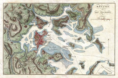
This is a photographic reproduction of an 1807 map of Boston and its immediate vicinity drawn by J. N. Buache for inclusion in the 1807 French edition of Marshall's Life of Washington.
::这是一部1807年波士顿及其附近地区地图的图片复制品 由J.N.Buache绘制 载入1807年《华盛顿马歇尔生命》的法文本
Settlers from New England traveled west across New York State and into the upper Midwest and the Great Lakes region. The Mid-Atlantic region, focused on Philadelphia, Pennsylvania, was known for its fertile soils, prosperous small-scale agriculture, and multinational population. Prosperous farming led to a vibrant economy and a robust network of towns and cities. People who migrated west from this region traveled down the Great Valley into the and across the into Kentucky, or they crossed Pennsylvania and traveled west via the Ohio River valley. The heart of the South was Virginia, a region oriented around plantation agriculture. The South was overwhelmingly rural, and in time the bulk of its agricultural workforce consisted of slaves brought to the United States from Sub-Saharan Africa.
::来自新英格兰的定居者从纽约州西经纽约州,进入上中西部和大湖地区,以宾夕法尼亚州费城为主的中大西洋地区以肥沃的土壤、繁荣的小规模农业和多国人口闻名。繁荣的农业带来了充满活力的经济和强大的城镇网络。从这个地区向西迁移的人从大谷到肯塔基州和横跨肯塔基州,或者穿越宾夕法尼亚州,经过俄亥俄河谷向西走。南方的心脏是弗吉尼亚州,是一个以种植园农业为主的地区。南方以农村为主,有时大部分农业劳动力由来自撒哈拉以南非洲的奴隶带到美国。Westward migration was spurred along by the of 1849 and by the completion of the in 1869. The settlement frontier pushed westward during the course of the 19th century and was declared “closed” by the Bureau of the Census in 1890. This did not mean that settlers were spread uniformly across the continent by 1890. Vast areas of the Great Plains and the mountain west remained sparsely populated by Europeans at that time. also encouraged westward migration by offering 160 acres of free land to households willing to move west. The continental United States had been organized into official states by the end of the 19th century with the exception of , , and .
::1849年和1869年的完成刺激了西向移民,19世纪的定居边界向西推移,1890年人口普查局宣布“关闭”,这并不意味着到1890年整个非洲大陆的定居者分布一致,大平原和西山的瓦斯特地区当时仍然为欧洲人所居住,人口稀少,也鼓励西向移民,向愿意向西移动的家庭提供160英亩自由土地。Most US residents at the beginnings of the country in 1776 had roots in Great Britain. Large numbers were also from other northern and western European countries. Moreover, the south had a substantial population from Africa, most of whom were slaves. During the 19th century, migrants continued to immigrate to the United States as its economy grew, especially after the 1830s. The German and Irish began arriving in large numbers, joining others from Britain and other countries.
::1776年美国最初的美国居民大多来自英国,大量人口也来自其他北欧和西欧国家。 此外,南部有大量来自非洲的人口,其中多数是奴隶。 19世纪,移民继续移民到美国,因为美国经济增长,特别是1830年代之后。 德国和爱尔兰人开始大量移民,来自英国和其他国家。As the century progressed, immigrants from Italy, Russia, and Austria came to the United States in masses. The new arrivals were different from the early British immigrants. They practiced Roman Catholic or Eastern Orthodox Christianity. They primarily moved to urban areas, and they found work in the new manufacturing sector growing rapidly in the Northeast and around the . Very few immigrants came from Latin America or Asia at that time. For a more detailed history of immigration in the United States, go to the website.
::随着本世纪的进步,来自意大利、俄罗斯和奥地利的移民大批来到美国,新移民与早期的英国移民不同,他们信奉罗马天主教或东方东正教。他们主要迁移到城市地区,发现新的制造业部门的工作在东北部和周边地区迅速增长。当时来自拉丁美洲或亚洲的移民很少。对于美国移民的更详细历史,请访问网站。Industrial Development and Urbanization
::工业发展和城市化The Industrial Revolution that began in Great Britain in the late 18th century eventually moved across the Atlantic and took hold in the United States. Rapid industrial growth emerged in the 19th century and was focused in the northeastern United States around the Great Lakes. This area is called the Manufacturing Belt. Mechanized manufacturing began with textiles in New England. Then it moved to steel and other metals in Pennsylvania and Indiana. Later, it was dominated by the manufacturing of automobiles in Michigan. Manufacturing would not have been possible without an abundant supply of power. Coal mining became an important industry in western Pennsylvania and in Appalachia.
::18世纪末在大不列颠开始的工业革命最终跨越大西洋,在美国扎根。19世纪出现了快速的工业增长,集中在大湖周围的美国东北部地区。这个地区被称为制造业 " 贝特 " ,机械制造业始于新英格兰的纺织业,随后在宾夕法尼亚州和印第安纳州转向钢铁和其他金属业。后来,它以密歇根州的汽车制造业为主。如果没有充足的电力供应,制造业就不可能实现。煤矿业成为西宾夕法尼亚州和阿帕拉契亚州的重要产业。Manufacturing took place in the cities and towns of the Manufacturing Belt. Not until the second half of the 20th century did manufacturing move to rural areas. Until then, it was almost entirely an urban activity. As the United States went through its Industrial Revolution, the population shifted from being almost entirely rural to being mostly urban. In 1790, only about 5 percent of the US population lived in urban areas. By 1920, about 50 percent lived in cities. As the rural to urban shift took place, the function and form of US cities also changed.
::直到20世纪下半叶制造业才迁往农村地区。在此之前,它几乎完全是一种城市活动。随着美国工业革命的到来,人口从几乎完全的农村转向大部分城市。1790年,只有大约5%的美国人口生活在城市地区。到1920年,大约50%的人口生活在城市。随着农村向城市的转变,美国城市的功能和形式也发生了变化。
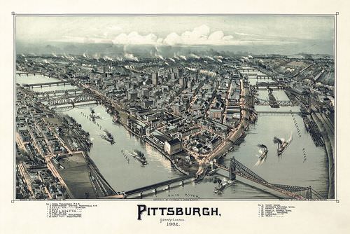
Pittsburgh, Pennsylvania was an important city in the Manufacturing Belt in the 1900s.
::匹兹堡 宾夕法尼亚州是19世纪 制造带的重要城市
From the colonial era until the late 19th century, US cities were walking cities. Because most Americans lived on farms, cities were small, compact, and centrally located as well as most activities were within walking distance. Only wealthy people had access to transportation by horse. City dwellers needed to live within a short distance of where they worked, shopped, and lived their daily lives.
::从殖民时代到19世纪末,美国城市都是步行城市。 由于大多数美国人生活在农场,城市规模小、紧凑、中心位置以及大部分活动都在步行距离之内。 只有富人可以乘马运输。 城市居民需要住在离他们工作、购物和日常生活很近的地方。
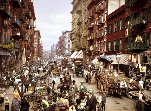
This photograph was taken on Mulberry Street on the Lower East Side in New York City in the early 1900s. It depicts a walking city.
::这张照片是在19世纪初 纽约市下东区Mulberry街拍的 描绘着一个行走的城市
The invention of the electric streetcar in 1888 allowed cities to increase in size. People could live farther from their place of employment as long as they lived within walking distance of a streetcar line. Streetcar suburbs grew up along streetcar lines. These neighborhoods were often segregated by ethnicity and race. Fewer people lived in downtown areas, which became dedicated to retail and manufacturing. Cities remained oriented around a , which was often located near the railway station. Factories needed to be near modes of transportation for both shipping in parts and shipping out completed products so that workers could easily get to work.
::1888年电动街车发明后,城市的规模得以扩大;人们只要住在街车线步行距离内,就可以居住在远离就业地点的地方;街车郊区沿街车线发展;这些街区往往按族裔和种族隔离;住在专门从事零售和制造业的市中心地区的人数较少;城市仍然以铁路站附近的一个城市为中心;工厂必须靠近零部件运输的运输方式,并运送成品,以便工人能够方便地上班。
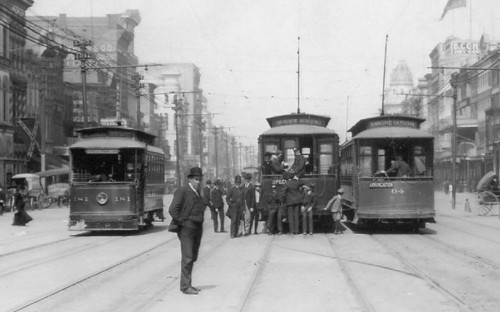
This picture of three street cars in New Orleans, Louisiana, shows the prevalence of street cars in the early 1900s.
::在路易斯安那州新奥尔良的三辆街头汽车中,
Large numbers of middle-class Americans began acquiring automobiles after 1920. This eventually led to a complete rethinking of the spatial layout of cities. Automobile suburbs sprang up outside the traditional city limits as people were able to buy homes far from streetcar lines or railway stations. Cities became increasingly decentralized. People could go shopping in suburban malls instead of downtown department stores.
::1920年后,大批中产阶级美国人开始购买汽车,这最终导致城市空间布局的彻底重新思考。 由于人们能够购买远离街车线或火车站的房屋,汽车行动郊区在传统的城市界限之外出现。 城市日益分散。 人们可以在郊区购物,而不是在市中心部门商店购物。Factories could be built at highway interchanges and not just near rivers and railroads. People could live in one suburb and work in another, instead of living in the suburbs and working downtown. Neighborhoods became even more racially and economically segregated than they had in the past, as middle-class whites moved into the new suburbs. Economically disadvantaged African Americans were left behind in the urban cores.
::工厂可以建在高速公路交汇处,而不仅仅是在河流和铁路附近。 人们可以居住在一个郊区,在另一个郊区工作,而不是住在郊区和在市中心工作。 随着中产阶级白人迁入新的郊区,邻里比过去更加种族和经济隔离。 经济上处于不利地位的非裔美国人被留在城市核心。
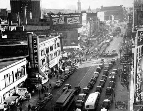
By the 1940s, the car culture was taking hold. This picture was taken in Minneapolis, Minnesota, in 1940.
::1940年代,汽车文化逐渐扎根。这张照片是1940年在明尼苏达明尼苏达明尼阿波利斯拍摄的。
By the late 20th century, the automobile had led to a new urban form called the "edge city". Edge cities are areas of dense urban development outside the boundaries of traditional cities. They often form at the intersection of major interstate highways and contain shopping malls, office complexes, high-rise apartment buildings, industrial parks, restaurants, and hotels. Sometimes edge cities are called suburban downtowns. Edge cities have supplanted the CBD as the place Americans call home.
::20世纪末,汽车导致了一种被称为“顶端城市”的新的城市形式。边缘城市是传统城市边界以外的密集城市发展地区。它们往往位于主要州际公路交汇处,包括购物中心、办公楼、高楼公寓楼、工业园、餐馆和旅馆。 有时边缘城市被称为郊区市中心。 边缘城市取代了《生物多样性公约》,成为美国人打电话回家的地方。
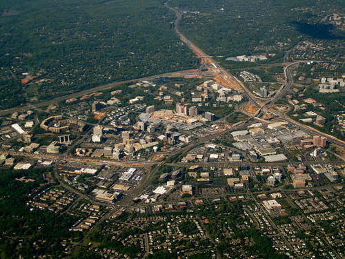
An aerial view of Tysons, Virginia, a typical edge city with a large amount of office and retail space.
::维吉尼亚州Tysons的空中景象,这是典型的边城,拥有大量的办公和零售空间。Economic Changes
::经济变化 经济变化For the purpose of understanding economic geography, all economic activities can be grouped into one of four categories, each with its respective terms, depending on the nature of what is being produced:
::为了了解经济地理,所有经济活动可分为四类之一,每一类都有各自的条件,视所生产产品的性质而定:-
Primary
economic sector activities include everything that pertains to the collection of raw materials, such as agriculture, forestry, fishing, and mining.
::主要经济部门的活动包括与收集农业、林业、渔业和采矿等原材料有关的所有活动。 -
Secondary
economic sector activities involve the processing of those raw materials through manufacturing.
::第二经济部门活动涉及通过制造业加工这些原材料。 -
Tertiary
economic sector activities are those that produce services, not physical products.
::经济部门的第三层活动是那些生产服务而不是有形产品的活动。 -
Quaternary
economic sector activities are those that deal with information collecting and processing, as well as management.
::四年度经济部门活动是那些涉及信息收集和处理以及管理的活动。
Clark's Sector Model illustrates the trends of the different economic sectors. With industrialization, the primary sector is in a decline and the tertiary sector is on an incline.
::克拉克的部门模型说明了不同经济部门的趋势。 随着工业化,初级部门正在衰退,第三产业部门正在萎缩。
The tertiary and quaternary economic sectors are often thought of together as the service sector. In the explanation of how countries gain national income, only primary and secondary activities produce actual physical products. Manufacturing traditionally earns the highest value-added profits. Tertiary activities are selective in gaining national wealth. For example, service activities such as tourism can bring in national wealth if the visitors are from outside the country. Tourism within a country can also influence economic conditions by increasing the amount of consumer spending.
::在解释各国如何获得国民收入时,只有初级和二级活动才产生实际的有形产品; 制造业传统上赚取最高增值利润; 三级活动有选择性地获取国家财富; 例如,旅游等服务活动如果来自国外,可以带来国民财富; 一国境内的旅游业也可以通过增加消费支出来影响经济条件。During the colonial era and into the 19th century, when the majority of Americans lived on farms and worked in agriculture, most economic activity in the United States took place within the primary economic sector. Today, the primary sector is still an important component of the US economy, but far fewer people are employed in it. For example, less than 1 percent of Americans make their living by farming, but agricultural output has continued to grow because of advancements in mechanization and the development of high-tech seeds, fertilizers, and pesticides. The United States has been able to export surplus agricultural output to other parts of the world. Fewer people work in coal mines than in the past, but because of new mining technologies and methods such as mountaintop removal, coal production remains high.
::在殖民时代和19世纪,大多数美国人生活在农场和农业中,美国的大部分经济活动都发生在初级经济部门。 如今,初级部门仍然是美国经济的重要组成部分,但就业人口却少得多。 比如,不到1%的美国人靠农业为生,但由于机械化的进步和高科技种子、化肥和杀虫剂的发展,农业产出继续增长。 美国已经能够向世界其他地方出口剩余农业产出。 煤矿工人比过去少,但是由于新的采矿技术和诸如清除山顶等方法,煤炭生产仍然居高不下。The geographic distribution of primary activities depends both on the location of natural features such as physical geography and climate and on the location of the market for a particular crop or resource. The 19th-century German economist Johann von Thünen created a model that predicted land use around a central market. In his theory, the land closest to the market would be used to produce crops that were expensive to transport, such as dairy. Land far from the market would be used for the production of crops that were less expensive to transport and less perishable, such as grain.
::初级活动的地理分布既取决于自然特征的位置,如自然地理和气候,也取决于特定作物或资源的市场位置。 19世纪的德国经济学家约翰·冯图宁创造了一种模型,预测一个中央市场周围的土地使用情况。在他的理论中,最接近市场的土地将被用来生产运输昂贵的作物,如奶制品。远离市场的土地将被用于生产运输成本较低、谷物等易腐作物。

This diagram shows the Von Thünen's model of distribution of different types of farming at different distances from a city.
::该图显示了冯·图宁在远离城市的不同距离分配不同类型农业的模式。
The Von Thünen model predicts a series of concentric rings surrounding a central market, with each ring producing a different kind of crop. If the Von Thünen model is applied at a much larger scale to the United States as a whole, with the densely populated urban zone from Boston to Washington, D.C., the model is fairly accurate in predicting the United States’ agricultural land use. Dairy farms are found close to the market, grain farms are farther away, and ranch lands used for livestock production are even farther away.
::Von Thünen模型预测了围绕中央市场的一系列同心环,每个环生产不同种类的作物。 如果将Von Thünen模型大规模应用于整个美国,从波士顿到华盛顿特区的人口稠密的城市区,那么该模型在预测美国的农业用地方面相当准确。 戴瑞农场位于市场附近,谷物农场离市场更远,用于畜牧生产的牧场更远。Anything that involves the processing of raw materials, known as manufacturing, is a secondary activity. As the United States moved into the Industrial Revolution and into the mid-20th century, the percentage of the US workforce involved in manufacturing grew from almost nothing until it peaked in the late 1970s. It was the main area of economic growth for decades.
::任何涉及原材料加工(称为制造业)的活动都是次要活动。 随着美国进入工业革命并进入20世纪中叶,参与制造业的美国劳动力比例从几乎无增长增长到1970年代后期达到顶峰。 几十年来,美国是经济增长的主要领域。Although manufacturing was present in most areas of the country, it was focused in the northeastern United States and along the Great Lakes. Factories were close both to the reserves of labor and to the markets for manufactured products found in the densely populated Northeast. The steel industry was located in Pittsburgh and its environs because of the area’s access to raw materials. Iron ore was mined in Minnesota and transported via the Great Lakes. Coal was mined in Pennsylvania, West Virginia, and other parts of Appalachia.
::虽然该国大部分地区都存在制造业,但主要集中于美国东北部和大湖沿岸,工厂与劳动力储备和在人口稠密的东北地区发现的制成品市场相近,钢铁工业位于匹兹堡及其周边地区,因为该地区有原材料,铁矿石在明尼苏达开采,通过大湖运输,煤矿在宾夕法尼亚州、西弗吉尼亚州和阿帕拉奇亚其他地区开采。
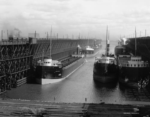
Ore docks of the Duluth, Missabe and Northern Railway loading ships in Duluth, Minnesota. The ship at the left front is George H. Russel, launched 1905, in Ecorse, Michigan. This picture was taken between 1900 and 1915.
::明尼苏达州杜卢斯、米萨贝和北铁路装载船的奥雷码头,左前方的船是乔治·鲁塞尔,1905年在密歇根州伊科塞发射,该图片拍摄于1900年至1915年。
As manufacturing has grown in other parts of the world, the secondary economic sector has declined in the United States. US labor statistics indicate that the United States lost about five million manufacturing jobs between 2000 and 2010. Many of these jobs were lost to countries with lower labor costs, such as Mexico or China.
::随着制造业在世界其他地方的增长,美国第二经济部门已经下降。 美国劳动力统计数据表明,美国在2000年至2010年间损失了大约500万个制造业工作岗位。 许多这些岗位都损失到了劳动力成本较低的国家,如墨西哥或中国。The third group of economic activities takes place in the tertiary and quaternary sectors, known as the service sector. Tertiary and quaternary activities create services, not physical products. Service jobs include everything from engineering to finance, restaurants to sports, and childcare to medicine. The tertiary sector makes up more than three-quarters of the US economy, as measured by its share of the gross domestic product (GDP), which is the total value of all goods and services produced in a country in a given year. The GDP is then divided by the country’s population to provide a GDP per capita statistic. Current data for GDP composition by Industry for the United States can be accessed at the .
::第三组经济活动是在第三产业和第四产业部门,即服务部门。第三产业和第四产业部门是服务行业,第三产业和第四产业活动创造的是服务,而不是物质产品。服务岗位包括从工程到金融、餐馆到体育、儿童保育到医药等所有内容。第三产业部门占美国经济的四分之三以上,以其在国内生产总值(GDP)中的份额来衡量,即一国在特定年份生产的所有商品和服务的总价值。然后,国内生产总值按国家人口分列,以提供人均GDP统计数据。美国工业的GDP构成目前数据可以访问美国。
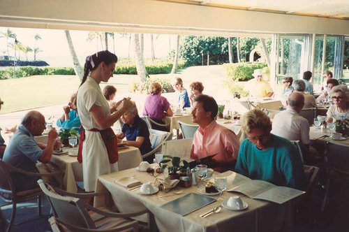
This picture of a waitress taking an order at Kahala Hilton Hotel in Hawaii is an example of a service job in the tertiary sector.
::在夏威夷的Kahala Hilton酒店订货的女服务员照片是第三产业服务工作的例子。
These figures show that the United States has shifted to a postindustrial service economy. The rise of the information age in the latter part of the 20th century shifted the workforce into the information sector. By the beginning of the 21st century, less than 2 percent of the US workforce was employed in agriculture, 15 percent in industry, 18 percent in services, and 65 percent in information activities.
::这些数字表明美国已经转向后工业服务经济。 20世纪后半叶信息时代的崛起将劳动力转向信息部门。 到21世纪初,不到2%的美国劳动力受雇于农业,15%的美国劳动力受雇于工业,18%的美国劳动力受雇于服务业,65%的美国劳动力受雇于信息活动。
This picture of engineers programming on computers is an example of the quaternary sector.
::工程师在计算机上编程的这种景象就是四面形部门的一个实例。
The locations of service-sector jobs are much more flexible than are jobs in the primary or secondary sectors. Another term for service-sector jobs is footloose jobs. For example, an accountant can live in New York or in Denver. Whereas it is much more difficult for factories to move from one place to another, and it is impossible for farms to relocate. Many of the information-technology jobs are emerging in the southern regions of the United States called the Sun Belt. Southern cities such as Atlanta, Dallas, and Phoenix are centers of innovation and population growth.
::与初级或二级就业相比,服务部门就业地点的灵活程度要大得多,服务部门工作的另一个术语是脚踏实地工作,例如,会计可以住在纽约或丹佛。工厂很难从一个地方搬到另一个地方,农场也不可能搬迁。许多信息技术工作正在美国南部地区出现,称为太阳带。亚特兰大、达拉斯和凤凰城等南方城市是创新和人口增长的中心。
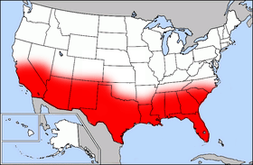
This map of the United States with the area highlighted in red depicts the Sun Belt.
::美国这张地图以红色显示的面积描绘了太阳带。
The warmer climate, combined with a lower cost of living and less congestion, makes the Sun Belt an attractive location for emerging information-based companies. Note that the popularity of the South and West for service-sector jobs only came about after the invention and adoption of air-conditioning. was not widespread until after World War II in the 1950s.
::气候变暖,加上生活费用降低和交通堵塞减少,使太阳带成为新兴信息型公司吸引新兴企业的地点。 注意,南部和西部在服务业就业的受欢迎程度只有在发明和采用空调之后才出现。 直到1950年代第二次世界大战之后,人们才普遍接受。While the population of the Southern states has increased, the population of some Northern states has decreased. The Sun Belt has always been a destination for people escaping the harsh winters of the Northern states. This has usually been only a seasonal transition. However, the new trend is one of permanent growth because of the increase in information technologies and in the service industry. Emerging companies looking to establish their businesses have targeted major cities from the Carolinas to the Southwest.
::虽然南方各州的人口有所增加,但一些北方州的人口却在减少。太阳带一直是逃离北方州严冬的人的目的地。这通常只是季节性过渡。然而,由于信息技术和服务业的增长,新的趋势是长期增长。 寻求建立企业的新兴公司把目标对准了从卡罗来纳州到西南部的主要城市。Houston, Texas is an example of a city in which companies and people are moving. According to the website, is the fourth largest city in the United States and the largest in Texas. Currently, the population in Houston is more than 2.2 million people and rapidly growing. It is a global and multicultural city, and only New York City has more company headquarters.
::德克萨斯州休斯顿市是一个公司和人员正在移动的城市的例子。 根据网站,这是美国第四大城市,也是得克萨斯州最大的城市。 目前,休斯顿市的人口超过220万,人口在迅速增长。 它是一个全球性和多文化的城市,只有纽约市拥有更多的公司总部。
Houston is the 4th largest city in the US and the largest in Texas. Only New York City has more Fortune 500 company headquarters.
::休斯顿是美国第四大城市,也是得克萨斯州最大的城市,只有纽约市拥有更多财富500个公司总部。Migration Patterns
::移徙模式The United States has undergone a massive rural-to-urban shift in its population. Moreover, intermigration within the United States from one region to another has also been prevalent. Each of the US regions has witnessed changes in demographics because of migration patterns.
::美国人口经历了大规模的农村人口向城市的转变。 此外,美国内部从一个地区向另一个地区的移民也十分普遍。 美国的每个地区都因为移民模式而发生了人口变化。In the agricultural regions of the United States, such as the Midwest, the migration pattern has been caused by changes in farm technology. Portions of the United States were opened up for agriculture because of the Homestead Act of 1862, where each person was given 160 acres from the government to start a farm. They could keep the acres if they lived on them and farmed them for a period of years. In the 1800s, 160 acres was enough land to support a family if environmental conditions were good.
::在美国的农业地区,如中西部地区,移徙模式是由农业技术的变化造成的,由于1862年的《住地法》,美国的一些地方被开放用于农业,其中每人从政府那里获得160英亩土地来开办农场,如果他们居住在那里并耕种了几年,他们可以保留这块土地,在1800年代,如果环境条件良好,160英亩土地足以养家糊口。The Industrial Revolution brought about improved farm equipment and technology. Larger and more expensive tractors and improved farming methods pushed the small farmers to sell out. Farms increased in size and fewer people were required to operate them. Since fewer farm workers are needed in rural areas, there has been a major rural-to-urban shift in the population. Central cities are increasing in population, while small towns and rural areas in the Midwest and across the nation are decreasing in population.
::工业革命改善了农业设备和技术,大而昂贵的拖拉机和改良的耕作方法迫使小农出售,农场面积扩大,需要经营农场的人数减少,农村地区需要的农场工人减少,农村人口向城市的重大转移,中央城市人口增加,中西部和全国小城镇和农村地区人口减少。Americanism and Globalization
::美国主义与全球化The freedom of personal expression in the United States has supported individual ingenuity to create the largest economy in the world. Citizens of the United States have pushed American corporations to become a major force in the world markets. Products and franchises from the US are distributed throughout the world. Items such as fast food, computers, news networks, and Hollywood movies have become the products of choice in countries across the globe.
::美国的个人言论自由支持了个人创造世界最大经济体的智慧。 美国公民将美国企业推向世界市场的主要力量。 美国的产品和专营权分布在世界各地。 快速食品、计算机、新闻网络和好莱坞电影等项目已经成为全球各国首选产品。
McDonald's has fast-food restaurants all over the world. This McDonald's operates in Moscow, Russia.
::麦当劳有全世界快餐餐厅,麦当劳在俄罗斯莫斯科经营
The English language dominates the Internet, which has been heavily influenced by US corporations. The power of the American Dream—the idea that through hard work anyone can achieve upward mobility and financial success—as it is portrayed in the US media, holds sway in the minds of people in the United States and abroad.
::英国语言主导了受到美国公司严重影响的互联网。 美国梦的力量 — — 即通过辛勤工作任何人都可以实现向上流动和金融成功的理念 — — 正如美国媒体所描述的那样 — — 在美国和国外人民的思想中占据了主导地位。News networks in the United States are so dominant that small countries, having no resources to create networks, rely on the US networks to deliver their news. Fast food franchises from the US exist in over 100 countries. Despite humble beginnings in Arkansas, Walmart grew to become the world’s largest corporation. It has become the buyer and seller of retail trade that shapes and molds cultural attitudes and fashions internationally.
::美国新闻网络占据主导地位,以至于没有资源创建网络的小国依靠美国网络发布新闻。 美国的快速食品专营权存在于100多个国家。 尽管在阿肯色州出现了微薄的开端,沃尔玛还是发展成为世界最大的公司。 它已成为塑造和塑造国际文化态度和时尚的零售贸易的买卖者。The size of the US population and the country’s vast resources have allowed it to become a world military superpower. After the fall of the Soviet Union, the United States became the most powerful military force in the world. The United States has also dominated the world’s economy and its communications networks. The advancements of multinational corporations have in essence enabled the sale of America to the rest of the world. The selling of American products and the large consumer market in the United States have provided the profits that have fueled global economic markets.
::美国的人口规模以及美国的巨大资源使美国成为世界军事超级大国。 在苏联垮台后,美国成为了世界上最强大的军事力量。 美国也主宰了世界经济及其通信网络。 跨国公司的发展实质上使美国得以向世界其他地区出售。 美国产品的销售和美国的大消费市场提供了刺激全球经济市场的利润。
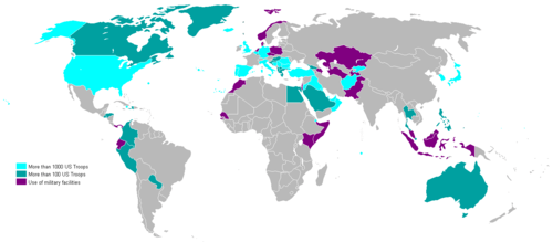
This 2007 world map shows the locations of US military bases.
::这幅2007年世界地图显示美国军事基地的位置。
The United States has become a worldwide franchise of its own. Corporate colonialism has advanced the American brand to a level that is now synonymous with consumerism, success, and power, worldwide. The reaction of the global community includes both admiration and disdain. Many view Americanism as interchangeable with globalization. Some welcome it; others reject it. The country of Iran is an example of this dichotomy. Young people in Iran wearing blue jeans gather in secret to watch American television programming from a hidden illegal satellite dish, while at the same time the anti-American forces in their government condemn America as decadent and imperialistic.
::公司殖民主义将美国品牌提升到现在与全世界消费主义、成功和权力同义的水平。全球社会的反应包括钦佩和鄙视。许多人认为美国主义可以与全球化互换。有些人欢迎美国主义;另一些人则反对美国主义。伊朗就是这种二分法的一个例子。 身穿蓝牛仔裤的伊朗年轻人秘密地聚集在一起,观看美国从隐藏的非法卫星天线上播放的电视节目,同时他们的政府的反美势力谴责美国是堕落和帝国主义。Corporate colonialism has become a dominant force impacting the global cultural fabric. Supporters appreciate access to American goods and services, while opponents claim that the English language and the American corporate franchise system are destroying the culture and heritage of untold millions who see their unique traditional ways of life being overshadowed and destroyed.
::公司殖民主义已成为影响全球文化结构的主导力量。 支持者欣赏获得美国商品和服务的机会,而反对者则声称英语和美国公司专营制度正在摧毁数以百万计的文化和遗产,他们看到自己独特的传统生活方式被蒙上阴影并被摧毁。Some argue that American television advertisements promote conformity and uniformity in American culture. They contend that America’s unique cultural diversity, which historically has provided originality is being eroded by the franchising of similar retail products, fast food, professional sports, and Hollywood entertainment that stifle the creative will of the American people. Others continue to see opportunities to pursue the American Dream and believe that innovation and ideas continue to emerge in spite of these trends.
::一些人认为美国电视广告可以促进美国文化的一致和统一。 他们认为美国独特的文化多样性 — — 历史上独创性的美国文化 — — 正在受到类似零售产品的特许经营、快餐、专业体育和好莱坞娱乐 — — 扼杀美国人民创造性意愿的侵蚀。 其他人继续看到追求美国梦想的机会,并相信尽管有这些趋势,创新和思想仍在出现。Many people worry about the future of the American Dream. American culture continues to evolve as people face changing economic and social conditions. Over the course of their history, Americans have faced both difficult and prosperous times, and now the future of this vibrant country is in the hands of the current generation. The United States has developed into one of the most powerful countries on the planet. Will the American Dream continue to motivate people in the future? Only time will tell.
::许多人担心美国梦的未来。 随着人们面临经济和社会条件的变化,美国文化继续演变。 在他们的历史过程中,美国人既面临着困难又繁荣的时代,而现在这个充满活力的国家的未来掌握在当代人手中。 美国已经发展成为地球上最强大的国家之一。 美国的梦想是否会继续激励人们的未来? 只有时间才能证明这一点。
Key Takeaways
::密钥外出-
The United States’ territory expanded gradually through various treaties and land acquisitions and was influenced by the concept of Manifest Destiny.
::美国领土通过各种条约和土地收购逐步扩大,受到明确命运概念的影响。 -
The three main colonial regions in the United States—New England, the Mid-Atlantic, and the South—had their own distinct economic foundations, settlement patterns, and social structures. People from these regions moved westward in particular migration patterns.
::美国的三个主要殖民地区——新英格兰、中大西洋和南方——有着它们自己的独特的经济基础、定居模式和社会结构,这些地区的人民向西移动,特别是移徙模式。 -
In the beginning of the 19th century, most immigrants were from western and northern Europe.
::19世纪初,大多数移民来自西欧和北欧。 -
By the end of the 19th century and the beginning of the 20th century, immigrants were coming in large numbers from southern and Eastern Europe and moving to industrial cities of the Northeast.
::到19世纪末和20世纪初,大批移民从南欧和东欧来到东北工业城市。 -
City structure changed from the walking cities of colonial America, to the railroad and streetcar cities of the late 19th century, to the automobile cities of the mid- and late-20th century.
::城市结构从美国殖民地的步行城市转变为19世纪末的铁路和街头汽车城市,从20世纪中期和末的汽车城市转变为20世纪末的汽车城市。 -
The US economy was initially based in the primary economic sector (particularly farming), then was based in the secondary economic sector (manufacturing), and is now oriented around the tertiary and quaternary economic sectors (services and information).
::美国经济最初以初级经济部门(特别是农业)为基础,然后以二级经济部门(制造业)为基础,现在以第三产业和第四产业经济部门(服务业和信息)为导向。 -
The diverse immigrants who have created American society have been unified by common aspirations and common ideals that created the concept of the American Dream. The concept indicates that regardless of one’s station in life, by working hard, applying oneself, and following the rules, one can obtain upward economic mobility.
::创建了美国社会的多样性移民被共同的愿望和共同理想统一起来,共同理想创造了美国梦的概念。 这一概念表明,无论一个人的人生地位如何,通过努力工作、运用自己和遵守规则,人们都可以获得向上的经济流动性。
Vocabulary Terms
::词汇术语术语Chapter 3.2 Early Development and Globalization
::第3.2章 早期发展和全球化Appalachian Mountains A mountain range that stretches from eastern Canada south to Alabama
::阿巴拉契亚山脉 从加拿大东部向南延伸至阿拉巴马cash crop C rops grow to be sold (examples are indigo, tobacco, cotton)
::种植将出售的经济作物作物(例如Indigo、烟草、棉花)diversity A variety or a wide range of differences
::多样性 多样性 多样性 或差异 差异 差异 差异 差异 差异 差异 差异 差异 差异 差异 差异 差异 差异 差异 差异 差异 差异 差异 差异 差异 差异 差异 差异 差异 差异 差异 差异 差异 差异 差异 差异 差异 差异 差异 差异 差异 差异Mid-Atlantic Region New York, New Jersey, Pennsylvania, Delaware
::中大西洋区域 纽约、新泽西、宾夕法尼亚、特拉华subsist e nce farming farmers produced just enough food for themselves and sometimes a little extra to trade in town
::仅能维持生计的农耕农民只生产足够的粮食供他们自己使用,有时还生产了比城镇贸易量多一点的粮食。Applying Knowledge
::应用知识Discussion and Study Questions
::讨论和研究问题-
What did “Manifest Destiny” mean for the United States?
::“最大命运”对美国意味着什么? -
From what European region did most early 19th century immigrants come? How did that change by the end of the 19th century?
::十九世纪初欧洲移民来自欧洲地区,十九世纪初移民来自何方? 到十九世纪末,这种变化如何? -
How did modes of transportation affect the layout of American cities?
::交通方式如何影响美国城市的布局? -
What is an edge city, and how did edge cities form?
::什么是边城,边城是如何形成的? -
How does the Von Thünen model relate to the spatial pattern of land use in the United States?
::Von Thünen模式与美国土地利用的空间格局有何关联? -
How have economic sectors shifted in the United States in the past two hundred years?
::过去二百年来,美国的经济部门是如何转变的? -
What is the American Dream, and how has it been expanded globally?
::《美国梦》是什么,它是如何在全球扩展的? -
What has been the major migration pattern in the Midwest region of the United States? Why is this occurring?
::美国中西部地区的主要移徙模式是什么?为什么会发生这种情况? -
What part of the United States has been a target for the location of the information age–based businesses? What was the role of air-conditioning technology in making this possible?
::美国的哪个部分成为信息时代企业定位的目标? 空调技术在实现这一目标方面能发挥什么作用? -
Outline some examples of how US culture influences the rest of the world.
::概述美国文化如何影响世界其他地方的一些例子。 -
Explain how the United States acquired its geographic boundaries.
::解释美国是如何获得其地理边界的。 -
List patterns of immigration to and migration within the United States through the period of westward settlement.
::向西定居期间向美国移民和在美国境内移徙的格局清单。 -
Describe urban growth and its connection to the development of new forms of transportation.
::描述城市增长及其与发展新运输形式发展的联系。 -
Explain which economic patterns helped the United States become the world’s largest economy.
::解释一下哪些经济格局帮助美国成为世界最大的经济体。 -
Describe how the concept of the American Dream has been exported globally.
::描述“美国梦”的概念是如何被全球输出的。
Real-World Geography Exercise
::现实世界地理演习Using , find a megalopolis located in one of the regions from the list below. Calculate the distance and how long it would take you to drive from your house to each one of these locations. Next, using , determine the latitude and longitude for each megalopolis you chose.
::使用时,从下面的列表中找到一个区域。计算距离和从你家开到每个地点需要多长时间。接下来,使用 ,确定您选择的每个大都市的纬度和经度。-
Cumberland Gap
::坎伯兰差距 -
Great Valley
::大河谷 -
Manufacturing Belt
::制造业带 -
Midwest
::中西部 -
Original thirteen colonies
::原十三个殖民地 -
Sun Belt
::太阳带
Mapping Exercise
::绘图绘制作业ESRI GEO Inquiry
::ESRI GEGO调查: Students will explore US census data to see the spatial differences in the United States’ population. The activity uses a web-based map
:::学生们将探索美国人口普查数据,以了解美国人口的空间差异。 活动使用基于网络的地图。Videos for Geography Enrichment
::地理丰富视频Helpful Websites for the Study of Geography
::地理研究有用网站is an encyclopedia funded by the Canadian government covering all branches of knowledge. Their scholarly collection includes interactive materials.
::该百科全书由加拿大政府资助,涵盖所有知识分支,其学术收藏包括交互式材料。provides information on the people, history, government, economy, energy, geography, communications, transportation, military, and transnational issues for the world's entities.
::向世界各实体提供关于人民、历史、政府、经济、能源、地理、通信、运输、军事和跨国问题的资料。is a US government website where you can find federal legislation, past and present, as well as information about the US legal system.
::是一个美国政府的网站,您可以在此找到过去和现在的联邦立法以及关于美国法律制度的信息。is a government agency website that provides current news, resources, topics of interest, information about drugs, careers in the DEA, and a tip hotline.
::是一个政府机构网站,提供最新消息、资源、感兴趣的话题、毒品信息、在缉毒局的职业以及一条小费热线。is the largest library in the world and provides manuscripts, files, information, pictures, and videos.
::图书馆是世界上最大的图书馆,提供手稿、文件、信息、图片和录像。is a US government agency website that allows users to search for and retrieve satellite images of Earth.
::这是一个美国政府机构的网站,用户可以搜索和检索地球的卫星图像。is a US government website that provides historical documents, photos, records, publications, and educator resources.
::这是一个美国政府网站,提供历史文件、照片、记录、出版物和教育资源。is a US government agency website that provides weather-related information and ocean research.
::是一个提供气象信息和海洋研究的美国政府机构网站。is a website by the United States Geological Survey and other federal, state, and local agencies that delivers topographic information for the United States.
::这是美国地质调查局和其他联邦、州和地方机构为美国提供地形信息的网站。is a massive central data source and a handy way to graphically compare nations.
::是一个庞大的中央数据源,是用图形比较国家的一种方便方式。is a website that measures most locations in the world for air pollution in real time.
::是一个实时测量世界上大多数空气污染地点的网站。is a unique statistical database, which allows you to research and compare a multitude of different data on US states.
::这是一个独特的统计数据库, 使你能够研究和比较关于美国各州的多种不同数据。is an international organization founded in 1945 and made up of 193 member states. The UN maintains international peace and security, protects human rights, delivers humanitarian aid, promotes sustainable development, and upholds international law.
::联合国是一个国际组织,成立于1945年,由193个成员国组成。 联合国维护国际和平与安全,保护人权,提供人道主义援助,促进可持续发展,维护国际法。is a US government agency that provides a population clock, data, surveys, statistics, a library with information and infographics, news about the economy, and much more.
::这是一个美国政府机构,它提供人口钟、数据、调查、统计、一个拥有信息和信息资料的图书馆、关于经济的新闻,以及更多。is a US government agency website that provides scientific information about the natural hazards that threaten lives, the natural resources we rely on, the health of our ecosystems and environment, and the impacts of climate and land-use change.
::这是一个美国政府机构的网站,提供科学信息,说明威胁生命的自然危害、我们赖以生存的自然资源、生态系统和环境的健康以及气候和土地使用变化的影响。is a US government website that provides the latest presidential news, information about the budget, policy, defense, and many more topics.
::提供最新总统新闻、预算、政策、国防等资讯, 以及更多议题。is under the United Nations and provides leadership on matters critical to health, shapes the research agenda on health, and monitors the health situation and assessing health trends around the world. Their website provides information on the state of health around the world, outbreaks, current health news, and more.
::网站提供世界各地卫生状况、疫情爆发、最新卫生新闻等信息。is an intergovernmental organization that regulates international trade. The website provides information on the history of the multilateral trading system, featured videos, news and events, trade topics, and more.
::该网站提供关于多边贸易体系历史的信息、视频、新闻和事件、贸易专题等等。 -
Explain how the United States acquired its geographic boundaries.
![Kwnd [Public domain], via Wikimedia Commons](https://dr282zn36sxxg.cloudfront.net/datastreams/f-d%3A88c835db7153f2512a493741d6203d34df6ac74a238414696792a6d1%2BIMAGE_THUMB_POSTCARD_TINY%2BIMAGE_THUMB_POSTCARD_TINY.1)