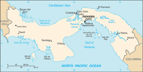
4.3 中美洲(1天)
章节大纲
-
Chapter Challenges
::章次 挑战-
Describe how the physical environment has affected human activity in Central America.
::说明自然环境如何影响中美洲人类活动。 -
List the various ways in which the United States has affected the region.
::列出美国对该区域造成影响的各种方式。 -
Explain the similarities and the differences among the Central American republics.
::解释中美洲各共和国之间的相似之处和不同之处。 -
Briefly summarize how the Panama Canal came to be constructed and what role the United States has played in Panama.
::简要说明巴拿马运河是如何建造的,美国在巴拿马发挥了什么作用。
Student Learning Objectives
::学生学习目标TEKS Regional Unit 04: Latin America; Chapter 4.3 Central America
::TERS 04区域股:拉丁美洲;第4.3章:中美洲WG.1B Trace the spatial diffusion of phenomena such as the Columbian Exchange or the diffusion of American popular culture and describe the effects on regions of contact
::WG.1B 追踪哥伦比亚交流会等现象的空间扩散或美国流行文化的传播,并描述对接触区域的影响WG.2A Describe the human and physical characteristics of the same regions at different periods of time to evaluate relationships between past events and current conditions
::WG.2A 描述同一区域在不同时期的人类和物理特征,以评估过去事件与当前状况之间的关系WG.4A Explain how elevation, latitude, wind systems, ocean currents, position on a continent, and mountain barriers influence temperature, precipitation, and distribution of climate regions
::WG.4A 解释高海拔、纬度、风系统、洋流、大陆位置、山地屏障如何影响气候区域的温度、降水和分布WG.6A Locate and describe human and physical features that influence the size and distribution of settlements
::WG.6A 确定并描述影响定居点规模和分布的人类和自然特征WG.6B Explain the processes that have caused changes in settlement patterns, including urbanization, transportation, access to and availability of resources, and economic activities
::WG.6B 解释导致住区模式变化的进程,包括城市化、运输、获得和获得资源以及经济活动WG.7D Examine benefits and challenges of globalization, including connectivity, standard of living, pandemics, and loss of local culture
::WG.7D 审查全球化的好处和挑战,包括连通性、生活水平、流行病和当地文化的丧失WG.8A Compare ways that humans depend on, adapt to, and modify the physical environment, including the influences of culture and technology
::WG.8A 比较人类依赖、适应和改变自然环境的方式,包括文化和技术的影响WG.8C Evaluate the economic and political relationships between settlements and the environment, including sustainable development and renewable/non-renewable resources. sustainable development and renewable/non-renewable resources
::WG.8C 评价住区与环境之间的经济和政治关系,包括可持续发展和可再生/不可再生资源。WG.10C Compare the ways people satisfy their basic needs through the production of goods and services such as subsistence agriculture versus commercial agriculture or cottage industries versus commercial industries
::WG.10C 比较人们通过生产商品和服务满足其基本需要的方式,如维持生计的农业、商业农业或家庭手工业、商业工业WG.10D Compare global trade patterns over time and examine the implications of globalization, including outsourcing and free trade zones
::WG.10D 比较随着时间推移的全球贸易格局并审查全球化的影响,包括外包和自由贸易区WG.11B Identify the factors affecting the location of different types of economic activities, including subsistence and commercial agriculture, manufacturing, and service industries
::WG.11B 查明影响各类经济活动地点的因素,包括维持生计和商业性农业、制造业和服务业WG.13A Interpret maps to explain the division of land, including man-made and natural borders, into separate political units such as cities, states, or countries
::WG.13A 解释地图,解释土地划分,包括人为和自然边界,分为不同的政治单位,如城市、州或国家Central America's Physical Environment
::中美洲的自然环境Central America is a land bridge connecting the North and South American continents, with the Pacific Ocean to its west and the Caribbean Sea to its east. Mountains dominate the interior from to . The coastal plains of Central America have tropical and humid type A climates. In the highland interior, the climate changes with elevation. As one travels up the mountainsides, the temperature cools. Only is located away from this interior mountain chain. Its rich soils and cooler climate have attracted more people to live in the mountainous regions than along the coast.
::中美洲是连接北美和南美洲大陆的陆地桥梁,西面是太平洋,东面是加勒比海,内陆以山区为主,中美洲沿海平原有热带和潮湿的A型气候。在高原内地,气候变化与高海拔相伴。随着高山高山高地,温度会降温,只有远离内山链,土壤丰富,气候更冷,吸引了更多的人生活在山区,而不是沿海地区。
Countries of Central America Name of territory, with flag Area (km²) Population (2016 est.) Population density (per km²) Capital Official language Human Development Index
Belize22,966 366,954 13 Belmopan English 0,715 High
Costa Rica51,100 4,857,274 82 San Jose Spanish 0,766 High
El Salvador21,040 6,344,722 292 San Salvador Spanish 0,666 Medium
Guatemala108,890 16,582,469 129 Guatemala City Spanish 0,627 Medium
Honduras112,090 9,112,867 67 Tegucigalpa Spanish 0,606 Medium
Nicaragua130,373 6,149,928 44 Managua Spanish 0,631 Medium
Panama78,200 4,034,119 44 Panama City Spanish 0,780 High Total 523,780 47,448,333 80 - - -
Hurricanes, tropical storms, earthquakes, and volcanic activity produce recurring environmental problems for Central America. In 1998, Hurricane Mitch swept through the region, devastating and , which had already been devastated by civil wars in previous years.
::飓风、热带风暴、地震和火山活动给中美洲带来了反复出现的环境问题。 1998年,米奇飓风横扫了该区域,造成了毁灭性的破坏,前几年已经遭受内战的破坏。The volcanic activity along the central mountain chain over time has provided rich volcanic soils in the mountain region. This has attracted people to work the land for agriculture. Central America has traditionally been a rural peripheral economic area in which most of the people have worked the land. Family size has been larger than average and the rural-to-urban shift dominates the migration patterns as the region urbanizes and industrializes. Natural disasters, poverty, large families, and a lack of economic opportunities have made life difficult in much of Central America.
::随着时间推移,沿中山链的火山活动为山区提供了丰富的火山土壤,吸引了人们耕种农业用地,中美洲传统上是一个农村外围经济区,大部分人耕种了土地,家庭规模大于平均水平,随着该区域城市化和工业化,农村人口向城市的转移主导了移徙模式,自然灾害、贫穷、大家庭和缺乏经济机会使中美洲大部分地区的生活困难。Altitudinal Zonation
::平纬区High mountains ranges run the length of Central and South America. The Andes Mountains of South America are the longest mountain chain in the world, and a large section of this mountain range is in the tropics. Tropical regions usually have humid type A climates. What is significant in Latin America is that while the climate at the base of the Andes may be type A, the different zones of climate and corresponding human activity vary as one moves up the mountain in elevation. Mountains have different climates at the base than at the summit. Type H highland climates describe mountainous areas that exhibit different climate types at varying degrees of elevation.
::高山脉分布在中美洲和南美洲,南美洲的安第斯山脉是世界上最长的山脉链,其中很大一部分山脉位于热带地区,热带地区通常有潮湿的A型气候,在拉丁美洲具有重要意义的是,虽然安第斯山脉底部的气候可能是A型,但不同的气候区和相应的人类活动因高山向上移动而不同,山底的气候与峰顶不同,高地气候类型描述的山区气候类型不同,海拔程度不同。Human activity varies with elevation, and the activities can be categorized into zones according to altitudinal zonation. Each zone has its own type of vegetation and agricultural activity suited to the climate found at that elevation. For every 1,000-foot increase in elevation, the temperature drops 3.5 ºF. In the tropical areas of Latin America, there are five established temperature-altitude zones. Elevation zones may vary depending on a particular location’s distance from the equator.
::人类活动因海拔而异,活动可按对等纬度划分为区,每个区都有适合该海拔气候的植被和农业活动,每增加1 000英尺,温度就会下降3.5oF。 在拉丁美洲热带地区,有5个固定的温度高度带,海拔区可能因特定地点与赤道的距离而不同。
This graphic illustrates the altitudinal zonation system in Latin America.
::这个图示显示了拉丁美洲的对等纬度区划系统。
Tierra Caliente ( Hot Land ): Sea Level to 2,500 Feet
::Tierra Caliente(热地):海平面至2 500英尺From sea level to 2,500 feet are the humid tropical lowlands found on the coastal plains. The coastal plains on the west coast of Middle America are quite narrow, but they are wider along the Caribbean coast. Vegetation includes tropical rain forests and tropical commercial plantations. Food crops include bananas, manioc, sweet potatoes, yams, corn, beans, and rice. Livestock is raised at this level, and sugarcane is an important cash crop. Tropical diseases are most common, and large human populations are not commonly attracted to this zone.
::从海平面到2 500英尺是沿海平原上发现的湿热带低地,中美西海岸的沿海平原很窄,但沿加勒比海岸范围更广,植被包括热带雨林和热带商业种植园,粮食作物包括香蕉、木薯、甜土豆、薯、玉米、豆类和稻米,牲畜按这一水平增加,甘蔗是重要的经济作物,热带疾病最为常见,大量人口不常被该地区吸引。Tierra Templada ( Temperate Land ): 2,501 to 6,000 Feet
::Tererra Templada(泰姆佩特拉地):2 501至6 000英尺From 2,501 to 6,000 feet is a zone with cooler temperatures than at sea level. This is the most populated zone of Latin America. Four of the seven capitals of the Central American republics are found in this zone. Just as temperate climates attract human activity, this zone provides a pleasant environment for habitation. The best coffee is grown at these elevations, and most other food crops can be grown here, including wheat and small grains.
::从2 501英尺到6 000英尺是一个温度比海平面温度更低的地区,这是拉丁美洲人口最多的地区,中美洲七个共和国的首都中,有四个都在这个地区。正如温和的气候吸引人类活动一样,这个地区为居住提供了舒适的环境。在这些高地种植最好的咖啡,其他大多数粮食作物可以在这里种植,包括小麦和小麦。Tierra Fria ( Cold Land ): 6,001 to 12,000 Feet
::地铁弗里亚州(冷战地):6 001至12 000英尺From 6,001 to 12,000 feet is the highest zone found in Middle America. This zone is usually the limit of the tree line, and few trees grow north of this zone. The shorter growing season and cooler temperatures found at these elevations are still adequate for growing agricultural crops of wheat, barley, potatoes, or corn. Livestock can graze and be raised on the grasslands. The Inca Empire of the Andes Mountains in South America flourished in this zone.
::从6 001英尺到12 000英尺是中美地区最高的地区,通常是树线的极限,在这个地区以北生长的树木很少,在这些高地的生长季节较短,温度更低,仍然足以种植小麦、大麦、土豆或玉米等农作物,牲畜可以在草原上放牧和饲养,南美洲安第斯山脉的印加帝国在这一地区蓬勃发展。Tierra Helada ( Frozen Land ): 12,001 to 15,000 Feet
::捷拉拉达(冻地):12 001至15 000英尺Some classify this as the “Puna” zone. At this elevation, there are no trees. The only human activity is the raising of livestock such as sheep or llama on any short grasses available in the highland meadows. Snow and cold dominate the zone. Central America does not have a tierra helada zone, but it is found in the higher Andes Mountain Ranges of South America.
::一些人将其划为“普纳”区,在这个高地上,没有树木,唯一的人类活动是在高地草原上任何短草上饲养绵羊或骆驼等牲畜,在高地草原上,寒雪占地势,中美洲没有丁甲肝带,但是在南美洲的安第斯山脉高处。Tierra Nevada ( Snowy Land ): Above 15,000 Feet
::地铁内华达州(雪地):15 000英尺以上There is little human activity above 15,000 feet. Permanent snow and ice are found here, and little vegetation is available. Many classification systems combine this zone with the tierra helada zone.
::人类活动面积在15 000英尺以上,这里有永久的雪和冰,几乎没有植被。许多分类系统将这个区域与高纬度带结合起来。European Colonialism
::欧洲殖民主义 欧洲殖民主义Amerindian groups dominated Central America before the European colonial powers arrived. The Maya are still prominent in the north and make up about half the population of Guatemala. Other Amerindian groups are encountered farther south, and many still speak their indigenous languages and hold to traditional cultural customs. People of European ancestry or upper-class mestizos now control political and economic power in Central America. Indigenous Amerindian groups are on the lower end of the socioeconomic status.
::在欧洲殖民国家到达之前,美洲印第安人群体以中美洲为主,玛雅人仍然在北部占显赫地位,占危地马拉人口的大约一半,其他美洲印第安人群体则在南部较远的地方遇到,许多美洲印第安人群体仍然说自己的土著语言,并坚持传统文化习俗,欧洲后裔或上等黑猩猩现在控制着中美洲的政治和经济权力,土著美洲印第安人群体处于社会经济地位的低端。
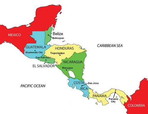
Map of the Central American Republics.
::中美洲共和国地图。
During colonial times, the Spanish conquistadors dominated Central America with the exception of the area of Belize, which was a British colony called British Honduras until 1981. Guatemala, El Salvador, Honduras, Nicaragua, and Costa Rica were Spanish colonies and became independent of Spain in the 1820s. Panama was a part of Colombia and was not independent until the United States started an independence movement in 1903 to develop the Panama Canal.
::在殖民时期,西班牙的征服者控制中美洲,伯利兹地区除外,伯利兹是1981年以前称为英属洪都拉斯的英国殖民地,危地马拉、萨尔瓦多、洪都拉斯、尼加拉瓜和哥斯达黎加是西班牙的殖民地,在1820年代独立于西班牙,巴拿马是哥伦比亚的一部分,直到美国于1903年发起发展巴拿马运河的独立运动才独立。As is usually the case with colonialism, the main religion and the lingua franca of the Central American states are those of the European colonizers, in this case, Roman Catholicism and Spanish. In some locations, the language and religion take on variant forms that mix the traditional with the European to create a unique local cultural environment.
::与通常的殖民主义情况一样,中美洲国家的主要宗教和通俗语言是欧洲殖民者的语言,这里指的是罗马天主教和西班牙语。 在某些地方,语言和宗教采取不同的形式,将传统与欧洲混为一谈,以创造独特的当地文化环境。People and Population
::人口和人口及人民及人口About 50 percent of the people of Central America live in rural areas. Because the economy is agriculturally based, family size has traditionally been large. Until the 1990s, family size averaged six children. As the pressures of the postindustrial age have influenced Central America, the average family size has been decreasing and is now about half of the pre-1990s and is declining. For example, the . The rural-to-urban shift is common, and as the region experiences more urbanization and industrialization, family size will decrease even more.
::中美洲大约50%的人口生活在农村地区,由于经济以农业为基础,家庭规模历来很大,直到1990年代以前,家庭平均规模平均为6个孩子,随着工业后时代的压力影响中美洲,平均家庭规模一直在下降,目前约为1990年代前的一半,并且正在下降。例如,农村向城市的转变十分普遍,随着该地区城市化和工业化程度的提高,家庭规模将进一步缩小。During the 20th century, much of Central America experienced development similar to stage 2 of the index of economic development. An influx of light industry and manufacturing firms seeking cheap labor has pushed many areas into stage 3 development. The primate cities and main urban centers are feeling the impact of this shift.
::20世纪,中美洲大部分地区经历了类似于经济发展指数第2阶段的发展。 轻工业和制造业企业大量涌入寻求廉价劳动力将许多地区推向了第3阶段的发展。 灵长类城市和主要城市中心正在感受到这一转变的影响。Over the years, larger family sizes have created populations with a higher percentage of young people and a lower percentage of older people. Cities are often overwhelmed with young migrants from the countryside with few or no places to live. Rapid urbanization places a strain on urban areas because services, infrastructure, and housing cannot keep pace with population growth. Slums with self-constructed housing districts emerge around the existing urban infrastructure. The United States has also become a destination for people looking for opportunities or advantages not found in these cities.
::多年来,家庭规模的扩大创造了年轻人比例较高的人口和老年人比例较低的人口,城市往往被来自农村的年轻移民所淹没,他们居住的地方很少或根本没有。快速城市化给城市地区带来了压力,因为服务、基础设施和住房无法跟上人口增长。现有城市基础设施周围出现了自建住房区的贫民窟。美国也已成为人们寻找这些城市所没有的机会或优势的目的地。
Largest Metropolitan Areas in Central America City Country Population Census Year % of National population (1) Guatemala City Guatemala
5,700,000 2010 26% (2) San Salvador El Salvador
2,415,217 2009 39% (3) Managua Nicaragua
1,918,000 2012 34% (4) Tegucigalpa Honduras
1,819,000 2010 24% (5) San Pedro Sula Honduras
1,600,000 2010 25% (6) Panama City Panama
1,400,000 2010 37% (7) San José Costa Rica
1,275,000 2013 30% CAFTA and Neocolonialism
::CAFTA和新殖民主义Just as Canada, the United States, and Mexico signed the into law in 1994, the United States and five Central American states signed the in 2006. The agreement was signed by trade representatives from El Salvador, Honduras, Nicaragua, Guatemala, and the United States. The CAFTA-DR agreement, which includes the Dominican Republic, was ratified in 2007. In 2010, Costa Rica’s legislature approved a measure to join the agreement.
::正如加拿大、美国和墨西哥于1994年签署成为法律一样,美国和五个中美洲国家于2006年签署了该协议。 该协议由萨尔瓦多、洪都拉斯、尼加拉瓜、危地马拉和美国的贸易代表签署。 2007年批准了包括多米尼加共和国在内的中美洲自由贸易协定。 2010年,哥斯达黎加立法机构批准了加入该协议的措施。CAFTA’s purpose is to reduce trade barriers between the United States and Central America. Reducing trade barriers affects labor, human rights, and the flow of wealth. During negotiations for CAFTA, US political forces cited CAFTA as a top priority and argued that it would help move forward the possibility of the larger , which would create a single market for the Americas.
::中美洲自由贸易协定(CAFTA)的目的是减少美国和中美洲之间的贸易壁垒。 减少贸易壁垒影响劳动、人权和财富流动。 在关于CAFTA的谈判中,美国政治力量将CAFTA列为最优先事项,并主张这将有助于推动扩大范围的可能性,这将为美洲创造单一市场。Countries gain national wealth in the three main ways: by growing it, extracting it, or manufacturing it. These methods contribute to a nation’s wealth only if the wealth stays within the country. With free-trade agreements such as NAFTA and CAFTA, the wealth gained from manufacturing, which has the highest value-added profits, does not stay in the country of production. Instead, the profits are transferred to the foreign corporation that controls the industrial factory. Multinational corporations profit from cheap labor sources and at the same time provide jobs for local people in Central America. These advantages usually result in lower product costs for consumers.
::各国以三种主要方式获得国民财富:通过种植、提取或制造。 只有在财富留在国内的情况下,这些方法才有助于一国的财富。 有了北美自由贸易协定和中美洲自由贸易协定等自由贸易协定,从制造业获得的财富 — — 其增值利润最高 — — 并不留在生产国。 相反,利润被转移到控制工业工厂的外国公司手中。 跨国公司从廉价的劳动力来源中获利,同时为中美洲的当地人民提供就业机会。 这些优势通常会降低消费者的产品成本。There have been protest marches and anti-CAFTA activities in many Central American countries. Costa Rica, one of the most stable countries in the region, had problems passing the agreement because of voter opposition. One of the primary arguments opponents to CAFTA make is that the wealth generated by the exploitation of cheap labor will not stay in Central America. instead, it will be removed by the wealthy core nations, just as European colonialism removed the wealth generated by the conquistadors and shipped it back to Europe. Those who oppose CAFTA and corporate colonialism also cite the following arguments:
::许多中美洲国家都发生了抗议游行和反中美洲自由贸易协定的活动。哥斯达黎加是该地区最稳定的国家之一,由于选民反对,协议难以通过。反对中美洲自由贸易协定的主要论点之一是,剥削廉价劳动力所创造的财富不会留在中美洲。 相反,它将被富裕的核心国家清除,正如欧洲殖民主义将征服者所创造的财富移走并运回欧洲一样。 反对中美洲自由贸易协定和企业殖民主义的人也引用了以下论点:-
A popular argument against CAFTA is that “free trade” is the same as corporate trade. Expanding corporate-controlled free trade makes the global south more dependent on the global north, and the corporations reap the profits.
::反对CAFTA的流行观点是“自由贸易”与公司贸易相同。 扩大公司控制的自由贸易让全球南方更加依赖全球北方,公司也获得利润。 -
CAFTA promotes corporate colonialism or neocolonialism. The “have” countries dominate and take advantage of the “have-not” countries to an ever-greater extent. The small countries of Central America cannot compete with large US corporations, which pressure and influence political systems to provide advantages and opportunities to exploit the smaller, weaker nations of Central America.
::CAFTA提倡公司殖民主义或新殖民主义。 “有”国家支配和利用“没有”国家的程度越来越大。 中美洲小国无法与美国大公司竞争,美国大公司施加压力和影响政治制度,以提供优势和机会剥削中美洲弱小国家。 -
CAFTA diminishes the power of Central American countries to regulate their own economies and protect their own citizens. The concentration of power in the hands of corporations with strong ties to those in political power allows the elite to maintain control over a country’s economy.
::中美洲自由贸易协定削弱了中美洲国家监管自身经济和保护本国公民的权力。 权力集中在与政治强权有强大联系的公司手中,使得精英能够控制一个国家的经济。 -
CAFTA forces small developing countries with no chance of competing successfully against the United States to open their markets to powerful US corporations.
::CAFTA迫使没有机会与美国成功竞争的发展中小国向强大的美国公司开放市场。 -
CAFTA leads to further privatization of social services, decreases public access to basic services, and gives corporations more money and control.
::CAFTA导致社会服务进一步私有化,减少公众获得基本服务的机会,并给予公司更多的资金和控制。 -
CAFTA forces competition for the lowest wages and lowest production costs, which drives wages down in the United States and keeps them down throughout Central America while at the same time providing huge profits to multinational corporations.
::中美洲自由贸易协定强力争夺最低工资和最低生产成本,这促使美国的工资下降,使整个中美洲的工资下降,同时为多国公司提供巨额利润。
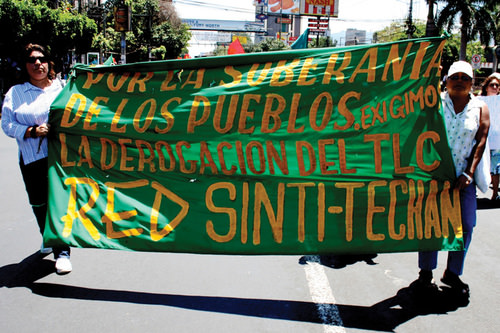
The banner reads, “For the sovereignty of the people…we demand the repeal of CAFTA (Central American Free Trade Agreement).”
::横幅上写着:“为了人民的主权......我们要求废除中美洲自由贸易协定。”
Supporters of CAFTA claim that it provides jobs, infrastructure, and opportunities to the developing countries of Central America. In return, cheap consumer goods are available to the people. The globalized economy is a mixed game. On the one hand, consumer goods are inexpensive to purchase; on the other hand, the world’s wealth flows into the hands of a few people at the top and is not always shared with most of the people who contribute to it.
::中美洲自由贸易协定的支持者声称,它为中美洲发展中国家提供了就业、基础设施和机会。 作为回报,廉价消费品可以提供给人民。 全球化经济是一个混合游戏。 一方面,消费品价格低廉,购买价格低廉;另一方面,世界财富流入上层少数人的手中,而且并非总能与大部分为之做出贡献的人分享。The Republics: Diverse Political Geography
::共和国:政治地理多样性Central American countries share similar climate patterns, but they do not share similar political or economic dynamics. The political geography of the region is diverse and ranges from a history of total civil war to peace and stability. The growing pains of each country as it competes and engages in the global economy often results in turmoil and conflict. Each state has found a different path, but each has dealt with similar issues with varying degrees of success. Barriers to progress range from political corruption to gang violence. Stability has come to the communities that have found new ways of gaining wealth and creating a higher standard of living.
::中美洲各国有着相似的气候模式,但并不具有类似的政治或经济动态,该区域的政治地理多种多样,从全面内战的历史到和平与稳定不等,每个国家在竞争和参与全球经济时不断增长的痛苦往往导致动荡和冲突。 每个国家都找到了不同的道路,但都处理过类似的问题,取得了不同程度的成功。 从政治腐败到帮派暴力,进步障碍不一而足。 已经找到获取财富和创造更高生活水平的新途径的社区也出现了稳定。Guatemala
::危地马拉 危地马拉 危地马拉 危地马拉
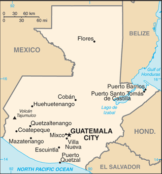
Map of Guatemala
::危地马拉地图地图
is bordered by Mexico to the north and west, the Pacific Ocean to the southwest, Belize to the northeast, the Caribbean to the east, Honduras to the east, and El Salvador to the southeast. Guatemala is the most populated country in Central America with more than 16 million people. Guatemala is a representative democracy. Its capital and largest city is Guatemala City. Spanish is the official language.
::危地马拉是中美洲人口最多的国家,人口超过1 600万,是具有代表性的民主国家,首都和大城市是危地马拉城,官方语言是西班牙语。In the late 1900s, Guatemala, El Salvador, and Nicaragua experienced devastating civil wars that divided their people and destroyed their economies. In the Mayan state of Guatemala, the 1960–96 civil war was fought between the right-wing Ladinos (urbanized mestizos and Maya) and the left-wing rural Amerindian Mayan majority. The reason for this war was the social reforms of President Jacobo Arbenz, which conflicted with the interests of the US-based United Fruit Company.
::19世纪末,危地马拉、萨尔瓦多和尼加拉瓜经历了破坏性内战,分裂了他们的人民,摧毁了他们的经济。 在危地马拉的玛雅州,1960-96年的内战在右翼拉迪诺斯(城市化梅斯蒂佐斯和玛雅)和左翼农村美洲印第安人玛雅人多数之间爆发。 这场战争的原因是总统雅各波·阿本茨的社会改革,这与美国联合水果公司的利益相冲突。In 1954, US-backed forces, funded by the , overthrew Arbenz and laid the groundwork for civil unrest for the next four decades. Right-wing and left-wing death squads terrorized the country until the latter 1990s when the Catholic Church brokered a peace accord. Guatemala is now moving forward on its path to recovery.
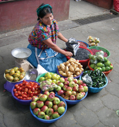
::1954年,美国支持的部队在阿尔本茨(Arbenz)的资助下推翻了阿尔本茨,为今后四十年的内乱打下了基础。 右翼和左翼行刑队在1990年代天主教会促成和平协议后期之前一直恐吓着国家。 危地马拉现在正在走向复苏之路。A woman dressed in traditional clothing selling fruit in a Guatemalan market.
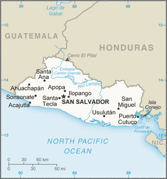
::一名穿着传统服装在危地马拉市场销售水果的妇女。El Salvador
::萨尔瓦多 萨尔瓦多
Map of El Salvador
::萨尔瓦多地图
, known as the land of volcanoes, is the smallest and the most densely populated country in Central America. It is bordered by the northern Pacific Ocean, Guatemala on the northwest side, and Honduras on the southeast. Its capital and largest city is San Salvador. As of 2017, the country had an estimated population of over six million. Mestizos make up most of the population at 86.3 percent. Spanish is the official language.
::位于北太平洋、西北边的危地马拉和东南部的洪都拉斯相邻,首都和最大的城市是圣萨尔瓦多,截至2017年,全国人口估计超过600万,梅斯蒂索人占人口总数的86.3%,西班牙语是官方语言。The civil war of 1979–92 was fought between the government-backed wealthy land-owning elite and the peasants who worked the land and lived in poverty. A few powerful families owned almost the entire country. Coffee is a major export crop for El Salvador, a country with a mild climate at its higher elevations. To protect their economic interests, US coffee companies backed the wealthy elite in El Salvador and lobbied the support of the US government. US military advisors and CIA support aided El Salvador’s government forces. At the same time, the peasants of El Salvador were soliciting support from Nicaragua and Cuba, which were backed by the Soviet Union.
::1979-92年的内战是政府支持的富有的拥有土地的精英阶层和农民与生活在贫困之中的农民之间的战争。 几个有权势的家庭几乎拥有整个国家。 咖啡是萨尔瓦多的主要出口作物,萨尔瓦多是一个高海拔地区气候温和的国家。 为了保护他们的经济利益,美国咖啡公司支持萨尔瓦多的富裕精英并游说美国政府的支持。 美国军事顾问和中央情报局支持萨尔瓦多政府军。 与此同时,萨尔瓦多农民正在寻求得到苏联支持的尼加拉瓜和古巴的支持。After the civil war devastated the country and killed an estimated 75,000 people, a peace agreement that included land reform was finally reached in 1992. El Salvador is a small country about the size of the US state of New Jersey with a population of more than six million people. The war devastated this rural mountainous country and forced more than 300,000 people to become refugees in other countries. Many migrated north to the United States. Recovery from the war has been difficult and has been hampered by natural disasters such as hurricanes and earthquakes.
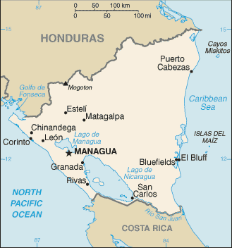
::萨尔瓦多是一个面积比美国新泽西州小的国家,人口超过600万。 这场战争摧毁了这个农村山区国家,迫使30多万人成为其他国家的难民。 许多人向北移民到美国。 战争的恢复一直困难重重,并受到飓风和地震等自然灾害的阻碍。Nicaragua
::尼加拉瓜 尼加拉瓜 尼加拉瓜
Map of Nicaragua
::尼加拉瓜地图
is the largest country in Central America. It is bordered by Honduras to the north, the Caribbean to the east, Costa Rica to the south, and the Pacific Ocean to the west. Managua is the capital and largest city and is also the third largest city in Central America. Spanish is the official language.
::中美洲是中美洲最大的国家,北与洪都拉斯接壤,东与加勒比接壤,南与哥斯达黎加接壤,西与太平洋接壤,马那瓜是首府和最大城市,也是中美洲第三大城市,西班牙语是官方语言。At the same time that civil wars were going on in Guatemala and El Salvador, there was conflict in Nicaragua. After US marines occupied the country from 1926 to 1933, the US-backed took power and remained there for decades. By 1978, violent opposition to governmental manipulation and corruption engulfed the country. An estimated 50,000 people died in a bitter civil war that ousted the Somoza regime and brought the Marxist Sandinista government to power in 1979.
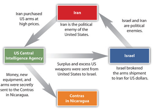
::与此同时,危地马拉和萨尔瓦多正在发生内战,尼加拉瓜也爆发了冲突。 1926-1933年美国海军陆战队占领了尼加拉瓜之后,美国后台掌权并在那里呆了几十年。 到1978年,暴力反对政府操纵和腐败的势力席卷了这个国家。 据估计有5万人死于一场残酷的内战,这场内战推翻了索莫扎政权,使马克思主义桑地尼斯塔政府于1979年掌权。Nicaraguan aid to leftist rebels in El Salvador caused the United States to sponsor anti-Sandinista contra (short for counterrevolutionary) guerrillas through much of the 1980s and to bring about a second Nicaraguan civil war. In 1982, the US Congress blocked direct US aid to the contra forces through the Boland Amendment. Covert activity by CIA operatives continued to fund the contra forces by selling surplus US arms to Iran, brokered through Israel.
::尼加拉瓜对萨尔瓦多左派叛军的援助导致美国在1980年代的大部分时间支持反反革命运动游击队,并引发了第二次尼加拉瓜内战。 1982年,美国国会通过《博兰修正案》阻止了美国对反对派部队的直接援助。 中央情报局特工的秘密活动继续通过通过以色列向伊朗出售美国多余的武器来资助反政府力量。In spite of a US embargo against Iran and animosity between Israel and Iran, the deals went through with hopes of negotiating the release of US hostages in . The profits from these illegal covert arms sales were funneled into support for the contra forces in Nicaragua. The scandal, known as the , has become a standard reference for US intervention in Central America.
::尽管美国对伊朗实施了禁运,以色列和伊朗之间也存在敌意,但交易还是满怀谈判释放美国人质的希望。 这些非法秘密武器销售的利润被转用于支持尼加拉瓜的反政府势力。 这一丑闻,即所谓的“丑闻 ” , 已经成为美国干预中美洲的标准参考。
This graphic illustrates the dynamics of the Iran-Contra Affair in Nicaragua.
::这个图示说明了尼加拉瓜伊朗-Contra Affair的动态。
In 1990, at the end of the Sandinista-Contra War, democratic elections were carried out. Regardless of the Iran-Contra Affair, the US-backed candidate defeated the Sandinista incumbent. An estimated 30,000 lives were lost between the Sandinistas and the contras. The country’s infrastructure and economy were both devastated after this era. Despite this history, the people of Nicaragua have worked hard to move forward. An effort to stabilize the country in the past decade has improved the potential for economic opportunities. Nicaragua has worked hard to promote tourism and to increase employment opportunities for its people.
::1990年,在桑地诺-康特拉战争结束时,尼加拉瓜进行了民主选举。 不管伊朗-康特拉公平,美国支持的候选人击败了桑地诺执政者。 在桑地诺人和反政府分子之间,估计有30,000人丧生。 尼加拉瓜的基础设施和经济在这个时代之后都遭受了破坏。 尽管历史如此,尼加拉瓜人民仍努力向前推进。 过去十年中稳定国家的努力提高了经济机会的潜力。 尼加拉瓜努力推动旅游业,增加人民的就业机会。Honduras
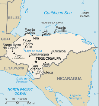
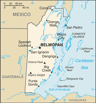
::洪都拉斯 洪都拉斯 洪都拉斯
Map of Honduras
::洪都拉斯地图
is a republic in Central America. It is bordered to the west by Guatemala, to the southwest by El Salvador, to the southeast by Nicaragua, to the south by the Pacific Ocean at the Gulf of Fonseca, and to the north by the Gulf of Honduras, a large inlet of the Caribbean Sea. Mestizos make up 90 percent of the population. Spanish is the official language.
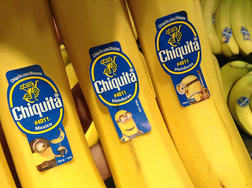
::它是中美洲的一个共和国,西与危地马拉接壤,西南与萨尔瓦多接壤,东南与尼加拉瓜接壤,南与太平洋接壤,丰塞卡湾,北与洪都拉斯湾接壤,洪都拉斯湾是加勒比海的一个大岛,梅斯蒂索斯占人口的90%,西班牙语是官方语言。Honduras has not experienced civil war, even though it is located in the midst of three politically unstable neighbors. It is considered a banana republic. American fruit companies have dominated the economy of this poor country and have supported the buildup of arms to ensure its stability. The term banana republic is used to explain that the region was dominated by foreign companies that grew bananas for export. Often the fruit companies would buy up large tracts of land and employ those displaced from the land to help grow the bananas.
::洪都拉斯没有经历过内战,尽管它位于三个政治不稳定的邻国之中,它被认为是一个香蕉共和国。 美国水果公司控制了这个贫穷国家的经济,支持军备集结以确保其稳定。 香蕉共和国一词用来解释该地区由种植香蕉出口的外国公司控制。 水果公司往往会购买大片土地,雇用那些从土地上流离的人帮助种植香蕉。
Guatemala, Nicaragua, and Honduras have been dominated by US corporate interests.
::危地马拉、尼加拉瓜和洪都拉斯一直以美国公司利益为主。
There have been incidences in history when US fruit companies involved themselves in the political affairs of Central American countries to gain an economic advantage. Foreign fruit companies have monopolized the market in Central America to extract higher profits and control economic regulations. At the present time, international corporations have started to invest in places such as Honduras to capitalize on the country’s cheap labor pool and relatively stable economic and political conditions.
::历史上曾经发生过美国水果公司参与中美洲国家政治事务以获得经济优势的事件。 外国水果公司垄断了中美洲市场以获取更高的利润和控制经济监管。 目前,国际公司开始在洪都拉斯等地投资,以利用该国廉价劳动力库以及相对稳定的经济和政治条件。Costa Rica
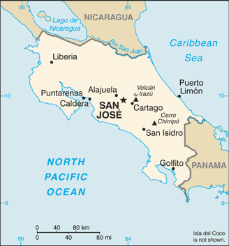
::哥斯达黎加 哥斯达黎加
Map of Costa Rica
::哥斯达黎加地图
is a democratic and peaceful country, which does not have an army. It is bordered by Nicaragua to the north, Panama to the southeast, the Pacific Ocean to the west, the Caribbean Sea to the east, and Ecuador to the south of Cocos Island. San Jose is the capital and largest city. As of 2017, the population is estimated to be almost five million people. Spanish is the official language. This stable country with a growing economy has earned the country the nickname the Switzerland of Central America .
::尼加拉瓜是一个民主与和平的国家,没有军队,北部与尼加拉瓜接壤,东南部与巴拿马接壤,西部与太平洋接壤,东部与加勒比海接壤,南部与厄瓜多尔接壤,科科斯岛以南,圣何塞是首都和最大城市,截至2017年,人口估计近500万人,西班牙语为官方语言,经济不断增长的稳定国家获得了中美洲瑞士的绰号。Multinational companies have been moving here to take advantage of the good economic conditions, low labor costs, and supportive environment for its employees. The California-based has a large microchip-manufacturing site in Costa Rica, which contributes heavily to the country’s economy. The tropical climate and stable economy of Costa Rica also attract US tourists as well as retirees looking for a new home. Costa Rica relies on tourism, outside forces, and economic development to finance their country.
::跨国公司一直在利用良好的经济条件、低劳动成本和对员工的支持性环境。 加利福尼亚州在哥斯达黎加拥有一个大型微芯片制造站点,为国家经济做出了巨大贡献。 哥斯达黎加的热带气候和稳定经济也吸引了美国游客和退休人员寻找新家。 哥斯达黎加依靠旅游业、外部力量和经济发展为国家融资。Belize
::伯利兹伯利兹伯利兹
Map of Belize
::伯利兹地图
is on the eastern coast of Central America. It is bordered on the north by Mexico, on the south and west by Guatemala, and on the east by the Caribbean Sea. The population is approximately four million and has the lowest population density in Central America. English is the official language. Spanish is gaining momentum because of immigration. It has the longest coral reef in the Western Hemisphere and has been promoting ecotourism as a means of economic development. Belize is in ecosystems and various species, which makes it an important location in the .
::伯利兹北部与墨西哥接壤,南部和西部与危地马拉接壤,东部与加勒比海接壤,人口约400万,是中美洲人口密度最低的国家,英语是中美洲官方语言,西班牙语因移民而增加,西半球珊瑚礁最长,并一直提倡生态旅游作为经济发展的手段,伯利兹拥有生态系统和各种物种,因此是中美洲的重要地点。After hurricanes almost destroyed the coastal Belize City, the country shifted its capital 45 miles inland to Belmopan as a protective measure. Belmopan is a small, centrally located city with only about 10,000 people. It is called a forward capital, a term used to describe a capital city of a country that has been moved to better serve or protect the country’s interests.
::在飓风几乎摧毁了伯利兹沿海城市之后,作为保护措施,伯利兹将首都45英里移到内陆的贝尔莫潘(Belmopan ) 。 贝尔莫潘(Belmopan)是一个面积小的中央城市,只有大约10,000人。 它被称为前方首都,用来描述一个国家为更好地服务或保护国家利益而搬迁的首都。Panama and the Panama Canal
::巴拿马和巴拿马运河
Map of Panama
::巴拿马地图
is bordered by Costa Rica to the west, Colombia to the southeast, the Caribbean Sea to the north, and the Pacific Ocean to the south. The capital and largest city is Panama City. In 2017, the estimated population was close to four million people. Spanish is the official language, but a variety of other languages are spoken, such as indigenous languages, Arabic, English, Chinese, Creole, Japanese, Korean, and more.
::哥斯达黎加西部与哥斯达黎加接壤,东南部与哥伦比亚接壤,北部与加勒比海接壤,南部与太平洋接壤,首都与最大城市为巴拿马城,2017年,人口估计数接近400万人,西班牙语为官方语言,但讲多种其他语言,如土著语言、阿拉伯语、英语、中文、克里奥尔语、日语、韩语等。During the 1880s, the region of Panama was part of South America and was controlled by colonial Colombia, which was formerly colonized by Spain. To travel from the Atlantic Ocean to the Pacific Ocean, ships had to sail around the southern tip of South America, which was time-consuming and difficult to navigate in some places because of ocean currents.
::1880年代,巴拿马地区是南美洲的一部分,由殖民哥伦比亚控制,哥伦比亚以前曾被西班牙殖民,从大西洋到太平洋,船只不得不绕着南美洲南端航行,南美南端很费时,由于洋流,有些地方很难航行。France made an agreement with Colombia to purchase a strip of land in Panama 10 miles wide and about 50 miles long to build a canal. The French had experience in building the between the Red Sea and the Mediterranean and applied their skills in Panama. The tropical climate and swampy terrain defeated the French workers with , , and other tropical diseases.
::法国与哥伦比亚达成协议,在巴拿马购买一块10英里宽、大约50英里长的土地修建运河。 法国人有在红海和地中海之间建桥的经验,并在巴拿马运用他们的技能。 热带气候和沼泽地形使法国工人因(......)和其他热带疾病而战败。In the United States, there was an increasing need to shorten the shipping distance between California and New York. Before the United States took over the Panama Canal project after the French abandoned it, Panama was separated from Colombia in a brief civil war and declared independent in 1903.
::在美国,越来越需要缩短加利福尼亚与纽约之间的航运距离,在美国接管法国人放弃巴拿马运河项目之前,巴拿马在短暂的内战中脱离哥伦比亚,并于1903年宣布独立。Understanding the problems that the French had encountered, the United States first sent civil engineers and medical professionals to Panama to drain the swamps and apply tons of chemicals such as the insecticide to eradicate the mosquito population. These chemicals were later found to be toxic to humans but worked well in eliminating the mosquito problem. The Panama Canal was finally completed by the United States and opened for business in 1914 after tremendous difficulties had been overcome.
::了解法国人所遇到的问题,美国首先派遣土木工程师和医疗专业人员前往巴拿马,排干沼泽,使用杀虫剂等数吨化学品来消灭蚊虫,这些化学品后来被发现对人类有毒,但在消除蚊虫问题方面效果良好,巴拿马运河最后由美国完成,在克服了巨大的困难之后于1914年开业。Many workers were imported from the Caribbean to help build the canal, which changed the ethnic makeup of Panama’s population. About 14 percent of the population of Panama has West Indian ancestry, and many of the laborers were of African descent. The difference in ethnicity caused an early layering of society, with those from the Caribbean finding themselves at the lower end of the socioeconomic scale.
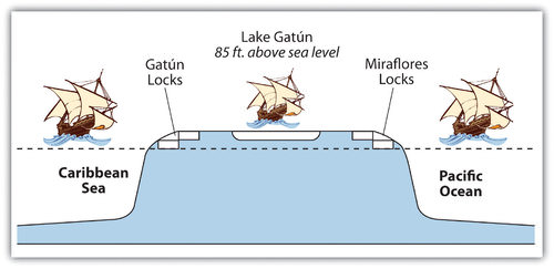
::许多工人都是从加勒比进口来帮助建设运河的,运河改变了巴拿马人口的种族构成。 大约14%的巴拿马人口拥有西印度血统,许多工人是非洲裔。 种族差异导致社会早期分层化,而来自加勒比的人则处于社会经济规模的低端。The Panama Canal is a marvel of engineering. An interior waterway was dammed up to create the artificial Lake Gatún at 85 feet above sea level. This large inland lake provides a freshwater channel extending most of the way across the Isthmus of Panama. Canal channels on each end of Lake Gatún connect it with the sea. Locks raise and lower ships from sea level to the 85-foot water level of the canal and the lake. Gravity provides fresh water from Lake Gatún to fill the locks that raise and lower ships. As ships travel through the locks, the fresh water is eventually emptied into the sea.
::巴拿马运河是一个工程奇迹,一个内河道铺设了一座海平面85英尺的人工加通湖,这个大型内陆湖提供了一条淡水通道,穿过巴拿马的地峡,通向加通湖的每一端的运河通道将运河与海洋连接起来,从海平面到运河和湖泊的85英尺水层的锁和下游船只上升和升降,从加通湖到加通湖,提供淡水,以填满升降船只的锁。随着船只的通航,淡水最终被清空入海洋。Rainfall is critical to resupply the water in Lake Gatún to keep the water channel constant and to keep the canal locks in operation. The canal channel has to be dredged periodically to keep it from silting in. In recent years, deforestation has reduced the number of trees around the lake, resulting in more silt entering the lake bed. A program to replant trees has been implemented to secure the lake and restore the natural conditions.
::降水对于补充加通湖的水以保持水渠的固定性并保持运河锁的运作至关重要,必须定期疏浚运河渠道,以免其淤塞。近年来,砍伐森林减少了湖周围树木的数量,导致更多的淤泥进入湖床。已实施了一项重新植树方案,以保障湖泊的安全并恢复自然条件。
The water for the locks is from Lake Gatún, which is 85 feet above sea level.
::锁的水来自加通湖,海拔85英尺。
Recently, the politics of the Panama Canal have become more of an issue than the operation of the canal itself. In 1977, US president, Jimmy Carter, entered into an agreement with Panamanian president, Omar Torrijos, to return the canal to the government of Panama. Under this agreement, both the Panama Canal Zone and the actual canal were to be returned to Panama by the end of 1999. Many Americans opposed the return of the canal to Panama. President Ronald Reagan campaigned on this position.
::最近,巴拿马运河的政治问题比运河本身的运作更严重。 1977年,美国总统卡特(Jimmy Carter)与巴拿马总统托里霍斯(Omar Torrijos)达成协议,将运河归还巴拿马政府。 根据这项协议,巴拿马运河区和实际运河将于1999年底归还巴拿马。 许多美国人反对将运河归还巴拿马。 里根总统支持这一立场。The United States had military installations in the Canal Zone and had used this area as a training ground for the Vietnam War and other military missions. The United States operated the School of the Americas (SOA) in the Canal Zone, which was a place to train counterinsurgents and military personnel from other countries. The SOA was moved to Fort Benning, Georgia, in 1984. It was renamed the Western Hemisphere Institute for Security Cooperation (WHINSEC) in 2001.
::美国在运河区拥有军事设施,并将这一地区用作越南战争和其他军事任务的训练场,美国在运河区经营美洲学校(SOA),该校是训练来自其他国家的反叛乱人员和军事人员的地方,1984年,SOA迁至格鲁吉亚本宁堡,2001年改名为西半球安全合作研究所(WHINSEC)。One of the early graduates of the SOA was a young Panamanian officer by the name of Manuel Noriega, who was placed on the CIA payroll in 1967. He was an important figure, helping with the US war against Nicaragua and serving US interests in the region in spite of the fact he was a known drug dealer. In May 1989, Noriega was elected president of Panama and became less supportive of US interests. In December of 1989, the United States invaded Panama and captured Noriega. He was sentenced to 40 years in a US prison for drug trafficking and held as a political prisoner.
::SOA早期毕业生之一名叫Manuel Noriega, 1967年被置于中央情报局工资单上的巴拿马青年军官。 他是一位重要人物,帮助美国对尼加拉瓜的战争,为美国在该地区的利益服务,尽管他是一个已知的毒贩。 1989年5月,Noriega当选为巴拿马总统,不再支持美国的利益。1989年12月,美国入侵巴拿马并逮捕了Noriega。 他因贩毒被判处40年徒刑,并被作为政治犯关押。Even after Noriega’s arrest, the United States was not allowed to retain use of the Canal Zone for military purposes, which was a major reason for the US presence in Panama. The Panama Canal Zone was an excellent geographical location for US military operations because it provided a base to monitor military activity in South America. US military planes could fly from US bases to Panama without refueling, and the planes could then fly out of Panama to monitor activity in South America.
::即使在诺列加被捕后,美国也不允许保留运河区用于军事目的,这是美国在巴拿马存在的主要原因。 巴拿马运河区是美国军事行动的极好地理位置,因为它为监测南美洲的军事活动提供了基地。 美国军用飞机可以在不加油的情况下从美国基地飞到巴拿马,然后从巴拿马飞出,以监测南美洲的活动。One of President Carter’s arguments for the return of the canal to Panama was that after the US military had supported the war with Colombia to make Panama independent in 1903, there had been no proper authorization from the Panamanian people to cede the Canal Zone to the United States. International law ruled that the Canal Zone was still sovereign Panamanian territory. The US military claimed the reason for remaining in the Canal Zone was to provide security for the canal.
::卡特总统主张将运河归还巴拿马的论据之一是,美国军方在1903年支持与哥伦比亚的战争,以使巴拿马独立之后,巴拿马人民没有正式授权将运河区割让给美国。 国际法裁定运河区仍是巴拿马主权领土。 美国军方声称留在运河区是为了保障运河区的安全。The Canal Zone and the actual Panama Canal were returned to Panama in 2000. Does the country of Panama, with about three million people, have the resources to manage and maintain the canal operations? To assist in economic development, Panama has established a free-trade zone next to the canal to entice international commerce. Originally established in 1948, the free-trade zone has become one of the largest of its kind in the world. Panama City has also become a hub of international banking with the claim of being a main money-laundering center for Colombian drug money. Panama is striving to be a main economic center for the region, which would advance economic globalization and trade for Panama.
::2000年运河区和实际巴拿马运河归还巴拿马。巴拿马约有300万人,巴拿马国家是否拥有管理和维持运河业务的资源?为了协助经济发展,巴拿马在运河旁边建立了一个自由贸易区,以吸引国际商业。自由贸易区最初于1948年建立,已成为世界上最大的此类地区之一。巴拿马城也已成为国际银行中心,声称是哥伦比亚毒品资金的主要洗钱中心。巴拿马正在努力成为该区域的主要经济中心,这将推动巴拿马的经济全球化和贸易。
Key Takeaways
::密钥外出-
Central America shares a similar climate type and physical features.
::中美洲的气候类型和物理特征相似。 -
Central America has enormous potential for tourism development.
::中美洲具有发展旅游业的巨大潜力。 -
The political history of the region is diverse, with each republic experiencing different political and economic conditions.
::该区域的政治历史多种多样,每个共和国的政治和经济状况各不相同。 -
High population growth and the rapid rural-to-urban shift has created higher unemployment rates and fewer economic opportunities.
::人口高速增长和农村向城市的快速转变导致失业率上升,经济机会减少。 -
CAFTA was implemented to help multinational corporations tap into the cheap labor pool.
::实施CAFTA是为了帮助跨国公司利用廉价劳动力。 -
The United States has had a major impact on this region both politically and economically.
::美国在政治和经济上对该区域产生了重大影响。 -
The United States has intervened in civil wars and invaded Panama.
::美国干预内战,入侵巴拿马。 -
US companies have dominated much of the region’s fruit and coffee production.
::美国公司控制了该地区大部分水果和咖啡生产。 -
The United States has supported industrial activities and the implementation of CAFTA.
::美国支持工业活动和执行中美洲自由贸易协定。 -
The Panama Canal has been a vital transportation link between the Atlantic and Pacific Oceans for the United States and the world.
::巴拿马运河一直是美国和世界在大西洋和太平洋之间的重要运输通道。 -
The Panama Canal Zone was a valuable strategic location for the operation of US military exercises.
::巴拿马运河区是美国开展军事演习的宝贵战略地点。 -
The United States was a major controller of the Panama Canal until the year 2000 when the canal and the Canal Zone was returned to Panama.
::美国是巴拿马运河的主要控制者,直到2000年运河和运河区归还巴拿马为止。
Vocabulary Terms
::词汇术语术语Chapter 4.3 Central America
::第4.3章 中美洲arable
::易可燃Land that is able to support the growing of crops
::能够支持作物种植的土地CAFTA-Central America Free Trade Agreement
::CAFT-中美洲自由贸易协定An expansion of NAFTA to five Central American nations (Guatemala, El Salvador, Honduras, Costa Rica and Nicaragua), and the Dominican Republic
::北美自由贸易协定扩展到五个中美洲国家(危地马拉、萨尔瓦多、洪都拉斯、哥斯达黎加和尼加拉瓜)和多米尼加共和国cash c rop
::经济作物A crop such as sugar, cotton, and coffee that is grown for sale and is usually a country's or region's primary commodity
::一种作物,如糖、棉花和咖啡,种植出售,通常是一国或区域的初级商品Mesoamerican
::中美洲A region of Central America, Mexico, and South America where several pre-Columbian civilizations lived including the Maya, Inca, and Aztecs
::中美洲、墨西哥和南美洲的一个区域,有一些哥伦比亚前文明,包括玛雅人、因卡人和阿兹泰克人。Panama Canal
::巴拿马运河A canal that crosses the isthmus of Panama connecting the Atlantic and Pacific Oceans. Built by the United States between 1904 and 1914
::一条横跨巴拿马与大西洋和太平洋相连的巴拿马地峡的运河,1904年至1914年由美国建造terrace farming
::梯田耕种The cutting out of flat areas (terraces) into near vertical slopes to allow farming. Terrace farms appear as steps cut into a mountainside. This adaptation allowed both the early Chinese and the Inca of Mesoamerica to grow enough food for their large populations
::将平板地区(平板地区)切入近垂直斜坡以进行耕作。 双层农场似乎像切入山边的阶梯。 这种适应使早期中国人和中美洲印加人得以种植足够的粮食,供大量人口使用。Triangle Trade
::三角三角贸易贸易A catch-all phrase for the trade occurring between Europe, Africa, and the Americas. Trade goods include raw materials from the Americas, manufactured goods from Europe, and slaves from Africa
::欧洲、非洲和美洲之间贸易的总括性短语,贸易商品包括美洲的原材料、欧洲的制成品和非洲奴隶。slave trade
::贩卖奴隶贩卖奴隶奴隶贸易The buying and selling of people for the purposes of slavery
::为奴役目的买卖人口slavery
::奴役奴役奴役奴役奴役奴役奴役奴役奴役A system of forced labor
::强迫劳动制度Applying Knowledge
::应用知识Interactive Notebook Activities
::互动笔记活动-
Describe how the physical environment has affected human activity in Central America.
::说明自然环境如何影响中美洲人类活动。 -
List the various ways in which the United States has affected the region.
::列出美国对该区域造成影响的各种方式。 -
Explain the similarities and the differences among the Central American republics.
::解释中美洲各共和国之间的相似之处和不同之处。 -
Briefly summarize how the Panama Canal came to be constructed and what role the United States has played in Panama
::简要说明巴拿马运河是如何建造的,美国在巴拿马发挥了什么作用
Discussion and Study Questions
::讨论和研究问题-
How does the altitudinal zonation influence human activity? What are the main altitudinal zones?
::对等纬度如何影响人类活动?主要对等区是什么? -
What geographic aspects do the Central American republics share?
::中美洲各共和国在地理方面有哪些共同点? -
How are the Central American republics different in their political histories?
::中美洲各共和国的政治历史有何不同? -
How does one define a banana republic? Where is it found in Central America?
::如何定义香蕉共和国?在中美洲在哪里找到的? -
What countries are included in CAFTA-DR? Why would anyone oppose this agreement?
::中亚自由贸易协定包括哪些国家? 为什么会有人反对这一协定? -
What was the Iran-Contra Affair? How does this portray the politics of the region?
::伊朗-反伊朗的公平是什么? 这如何描绘该地区的政治? -
How does Costa Rica attract US business ventures?
::哥斯达黎加如何吸引美国企业? -
Who started building the Panama Canal? Who completed it? Who controls it today?
::谁开始建造巴拿马运河?谁完成了?谁今天控制了运河? -
How did the building of the Panama Canal change Panama’s ethnic makeup?
::巴拿马运河的建筑如何改变了巴拿马的族裔构成? -
Why was the Panama Canal so important to the United States?
::为什么巴拿马运河对美国如此重要?
Real-World Geography Exercise
::现实世界地理演习-
Using
, complete the following activities:
-
Locate each place on the bulleted list below.
::在下面的子弹名单上 找到每个地方 -
Find an international airport in proximity to each location on the bulleted list below.
::在下面子弹清单上的每个地点附近找到一个国际机场。 -
Calculate the distance and travel time by plane to each city from the
in Albuquerque, New Mexico.
::计算从新墨西哥的阿尔布开克 到每个城市的距离和旅行时间
::使用,完成以下活动: 在下面的子弹清单上找到每个地点; 在下面子弹清单上找到一个靠近每个地点的国际机场; 计算从新墨西哥的阿尔布开克飞往每个城市的飞机距离和飞行时间。 -
Locate each place on the bulleted list below.
-
Using
, determine the latitude and longitude for each location on the bulleted list below.
::使用,确定以下子弹列表中每个位置的纬度和经度。 -
Be prepared to share and discuss your answers.
::准备分享和讨论你的答案
-
Panama Canal
::巴拿马运河 -
Panama City, Panama
::巴拿马巴拿马城巴拿马城 -
San Jose, Costa Rica
::哥斯达黎加圣何塞 -
Belmopan, Belize
::伯利兹贝尔莫潘 -
Managua, Nicaragua
::尼加拉瓜马那瓜 -
Tegucigalpa, Honduras
::洪都拉斯特古西加尔巴 -
San Salvador, El Salvador
::萨尔瓦多,圣萨尔瓦多 -
Guatemala City, Guatemala
::危地马拉,危地马拉,危地马拉,危地马拉城
Mapping Exercise
::绘图绘制作业Mapping Our World ESRI-ARGIS Online Module 7 Lesson 2
::绘制我们世界的ESRI-ARGIS在线模块7第二课: Students will study Hurricane Mitch, the deadliest storm of the twentieth century, and the havoc it wreaked on several Central American countries. They will analyze information about the storm itself and about the region before the storm, and they will consider the storm’s consequences.
::学生们将研究20世纪最致命的风暴米奇(Mitch ) , 以及它给几个中美洲国家带来的灾难。 他们将分析风暴本身和风暴前地区的信息,并将考虑风暴的后果。-download
::- 下载-download
::- 下载-download
::- 下载Videos for Geography Enrichment
::地理丰富视频Helpful Websites for the Study of Geography
::地理研究有用网站is an encyclopedia funded by the Canadian government covering all branches of knowledge. Their scholarly collection includes interactive materials.
::该百科全书由加拿大政府资助,涵盖所有知识分支,其学术收藏包括交互式材料。provides information on the people, history, government, economy, energy, geography, communications, transportation, military, and transnational issues for the world's entities.
::向世界各实体提供关于人民、历史、政府、经济、能源、地理、通信、运输、军事和跨国问题的资料。is a US government website where you can find federal legislation, past and present, as well as information about the US legal system.
::是一个美国政府的网站,您可以在此找到过去和现在的联邦立法以及关于美国法律制度的信息。is a government agency website that provides current news, resources, topics of interest, information about drugs, careers in the DEA, and a tip hotline.
::是一个政府机构网站,提供最新消息、资源、感兴趣的话题、毒品信息、在缉毒局的职业以及一条小费热线。is the largest library in the world and provides manuscripts, files, information, pictures, and videos.
::图书馆是世界上最大的图书馆,提供手稿、文件、信息、图片和录像。is a US government agency website that allows users to search for and retrieve satellite images of Earth.
::这是一个美国政府机构的网站,用户可以搜索和检索地球的卫星图像。is a US government website that provides historical documents, photos, records, publications, and educator resources.
::这是一个美国政府网站,提供历史文件、照片、记录、出版物和教育资源。is a US government agency website that provides weather-related information and ocean research.
::是一个提供气象信息和海洋研究的美国政府机构网站。is a website by the United States Geological Survey and other federal, state, and local agencies that deliver topographic information for the United States.
::这是美国地质调查局和其他联邦、州和地方机构为美国提供地形信息的网站。is a massive central data source and a handy way to graphically compare nations.
::是一个庞大的中央数据源,是用图形比较国家的一种方便方式。is a website that measures most locations in the world for air pollution in real time.
::是一个实时测量世界上大多数空气污染地点的网站。is a unique statistical database, which allows you to research and compare a multitude of different data on US states.
::这是一个独特的统计数据库, 使你能够研究和比较关于美国各州的多种不同数据。is an international organization founded in 1945 and made up of 193 member states. The UN maintains international peace and security, protects human rights, delivers humanitarian aid, promotes sustainable development, and upholds international law.
::联合国是一个国际组织,成立于1945年,由193个成员国组成。 联合国维护国际和平与安全,保护人权,提供人道主义援助,促进可持续发展,维护国际法。is a US government agency that provides a population clock, data, surveys, statistics, a library with information and infographics, news about the economy, and much more.
::这是一个美国政府机构,它提供人口钟、数据、调查、统计、一个拥有信息和信息资料的图书馆、关于经济的新闻,以及更多。is a US government agency website that provides scientific information about the natural hazards that threaten lives, the natural resources we rely on, the health of our ecosystems and environment, and the impacts of climate and land-use change.
::这是一个美国政府机构的网站,提供科学信息,说明威胁生命的自然危害、我们赖以生存的自然资源、生态系统和环境的健康以及气候和土地使用变化的影响。is a US government website that provides the latest presidential news, information about the budget, policy, defense, and many more topics.
::提供最新总统新闻、预算、政策、国防等资讯, 以及更多议题。is under the United Nations and provides leadership on matters critical to health, shapes the research agenda on health, and monitors the health situation and assessing health trends around the world. Their website provides information on the state of health around the world, outbreaks, current health news, and more.
::网站提供世界各地卫生状况、疫情爆发、最新卫生新闻等信息。is an intergovernmental organization that regulates international trade. The website provides information on the history of the multilateral trading system, featured videos, news and events, trade topics, and more.
::该网站提供关于多边贸易体系历史的信息、视频、新闻和事件、贸易专题等等。Mapping Our World ESRI-ARGIS Online -
Describe how the physical environment has affected human activity in Central America.