4.7 巴西(2天)
章节大纲
-
Chapter Challenges
::章次 挑战-
Summarize briefly the ethnic composition of Brazil and describe why the population is so diverse.
::简要概述巴西的族裔组成,并描述巴西人口如此多样化的原因。 -
Explain how the core-periphery spatial relationship applies to the country.
::解释核心-周边空间关系如何适用于国家。 -
Explain how the dynamics of the country shape the core and the periphery.
::解释国家动态如何决定核心和外围。 -
Describe the main activities that are involved in the development and exploitation of the Amazon Basin.
::说明参与亚马孙流域开发和开发的主要活动。 -
Describe how deforestation affects the tropical rain forest and environmental conditions.
::说明毁林如何影响热带雨林和环境条件。 -
List the main characteristics and economic activities of the main regions of Brazil.
::列出巴西主要区域的主要特点和经济活动。
Student Learning Objectives
::学生学习目标TEKS Regional World Geography Unit 04: Chapter 4.7 Brazil
::TERS 区域世界地理股04:第4.7章WG.16B Describe elements of culture, including language, religion, beliefs and customs, institutions, and technologies.
::WG.16B 描述文化要素,包括语言、宗教、信仰和习俗、机构和技术。WG.16D Compare life in a variety of urban and rural areas in the world to evaluate political, economic, social, and environmental changes
::WG.16D 比较世界不同城市和农村地区的生活,以评价政治、经济、社会和环境变化WG.18A Analyze cultural changes in specific regions caused by migration, war, trade, innovations, and diffusion.
::WG.18A 分析移徙、战争、贸易、创新和传播在特定区域造成的文化变化。WG.18C Identify examples of cultures that maintain traditional ways, including traditional economies.
::WG.18C 查明保持传统方式的文化实例,包括传统经济。WG.19B Evaluate the significance of major technological innovations in the areas of transportation and energy that have been used to modify the physical environment.
::WG.19B 评价用于改变自然环境的运输和能源领域重大技术革新的重要性。WG.21A Analyze and evaluate the validity and utility of multiple sources of geographic information such as primary and secondary sources, aerial photographs, and maps.
::WG.21A 分析和评价多种地理资料来源,例如主要和次要资料来源、航空照片和地图的有效性和效用。WG.21B Locate places of contemporary geopolitical significance on a map.
::WG.21B 在地图上标出具有当代地缘政治意义的地点。WG.22A Design and draw appropriate graphics such as maps, diagrams, tables, and graphs to communicate geographic features, distributions, and relationships. features, distributions, and relationships.
::WG.22A 设计和绘制适当的图形,如地图、图表、表格和图表,以交流地理特征、分布和关系、特征、分布和关系。WG.22C Use geographic terminology correctly.
::WG.22C 正确使用地理术语。WG.22D Use standard grammar, spelling, sentence structure, and punctuation.
::WG.22D 使用标准语法、拼写、句子结构和标点。WG.22E Create original work using proper citations and understanding and avoiding plagiarism.
::WG.22E 利用适当的引证和理解并避免损害,创建原创工作。Brazil
::巴西 巴西
Map of Brazil
::巴西地图图A Portuguese Colony
::葡萄牙殖民地, the largest country in South America, is similar in physical area to the continental United States without Alaska or Hawaii. is the dominant religion and Portuguese is the primary language. Once a Portuguese colony, the country’s culture was built on European immigration and African slave labor, making for a mixture of ethnic backgrounds.
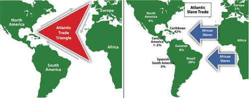
::作为南美最大的国家,南美洲的自然区域与没有阿拉斯加或夏威夷的美国大陆相似。 主要的宗教是葡萄牙语,主要语言是葡萄牙语。 一旦葡萄牙成为殖民地,该国的文化就建立在欧洲移民和非洲奴隶劳动之上,造成种族背景混杂。In colonial times, Brazil was a part of the Atlantic Trade Triangle, which functioned as a transportation conveyor, moving goods and people around the regions bordering the Atlantic Ocean. Colonial merchant ships financed by Europe’s wealthy elite brought goods to the African coast to trade for slaves, who were shipped to the Americas and the Caribbean to resolve the labor shortage in the colonies. The Atlantic Trade Triangle also moved food crops, sugar, tobacco, and rum from the colonies back to the European ports. The merchant ships never sailed with an empty hold, and their voyages provided enormous profits to European financiers.
::在殖民时代,巴西是大西洋贸易三角的一部分,它充当运输工具,在大西洋沿岸地区运送货物和人员。 由欧洲富人精英资助的殖民商船将货物运到非洲海岸交易奴隶,这些奴隶被运到美洲和加勒比解决殖民地的劳动力短缺问题。 大西洋贸易三角也把粮食作物、糖、烟草和朗姆酒从殖民地运回欧洲港口。 商船从未空船航行,它们的航行给欧洲金融家带来了巨大的利润。
This map depicts the Atlantic Trade Triangle.
::这幅地图描述了大西洋贸易三角。
The total number of individuals taken as slaves from Africa is unclear and often debated. It is estimated that more than ten million African slaves survived the from Africa to the Western Hemisphere. Slavery supplied cheap labor for the plantations and agricultural operations in the New World. Brazil took in more African slaves than any other single country—at least three million. Colonial Brazil thrived on early plantation agriculture. When slavery was abolished in Brazil in 1888, the freed slaves found themselves on the lower end of the socioeconomic hierarchy.
::据估计,从非洲到西半球,有1 000多万非洲奴隶幸存下来;奴隶制为新世界的种植园和农业活动提供了廉价劳动力;巴西比任何其他国家都多收了更多的非洲奴隶——至少300万;殖民地巴西依靠早期种植园农业为生;当1888年巴西废除奴隶制时,解放的奴隶处于社会经济等级体系的低端。People of mixed African descent now make up more than one-third of Brazil’s population. The Afro-Brazilian heritage remains strong and dominates the country’s east coast. The African influence is evident in everything from the samba schools of the Brazilian carnival to the music and traditions of the people. In spite of Brazil being a culturally diverse country, Africans still have not found themselves on an equal status in terms of economic or political opportunities in positions of power in the country.
::非洲裔混血非洲人后裔现在占巴西人口的三分之一以上,非裔巴西人的传统依然强大,并主宰着巴西的东海岸。 从巴西狂欢节的桑巴学校到人民的音乐和传统,非洲的影响都很明显。 尽管巴西是一个文化多样化的国家,但非洲人在经济或政治机会方面仍没有在国家权力地位上处于平等地位。
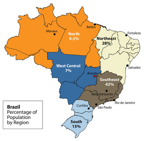
The peripheral region includes the large Amazon Basin of the north. Notice the many small states in the Northeast from Fortaleza to Salvador; these states are densely populated.
::周边区域包括北部的大型亚马逊流域。 请注意东北部从福塔莱萨到萨尔瓦多的许多小州;这些州人口稠密。Southeast Core: Urbanization and Industrialization
::东南部核心:城市化和工业化Brazil’s human development patterns are an example of the core-periphery spatial relationship. The main economic core area is located in the southeast region of Brazil, an area that is home to the largest cities of the realm and acts as the hub for industrial and economic activities. Political and economic power is held by elites residing in the urban core areas. The rural northern Amazon Basin is the heart of the periphery, providing raw materials and resources needed in the core. The periphery has a small population density, and most are Amerindian groups that make a living from subsistence agriculture, mining, and forestry. The rural-to-urban shift has prompted many of the rural poor to migrate to the large cities.
::巴西的人类发展模式是核心周边空间关系的一个例子。 主要经济核心地区位于巴西东南部地区,该地区是该地区最大城市的所在地,是工业和经济活动的中心。 政治和经济权力由居住在城市核心地区的精英掌握。 亚马逊河流域北部农村是外围地带的核心,提供了核心所需的原材料和资源。 外围人口密度小,大部分是靠自给农业、采矿和林业为生的美洲印第安人群体。 农村向城市的转变促使许多农村穷人迁移到大城市。Founded in 1554 as a Catholic mission, the city of São Paulo rests at the heart of the core region. Its pattern of development is similar to that of Mexico City. Coffee production was the early basis of the local economy. São Paulo is located about 30 miles inland from the coast. It has grown to be the center of trade and industry for Brazil. However, Rio de Janeiro receives greater attention from tourism. With more than 20 million people, São Paulo is the largest industrial metropolis south of the equator, the largest city in South America, and among one of the largest cities on Earth.
::圣保罗市成立于1554年,是天主教传教团,位于核心地区的核心,其发展模式与墨西哥城相似,咖啡生产是当地经济的早期基础,圣保罗位于离海岸30英里的内陆,已成为巴西贸易和工业的中心,但里约热内卢受到旅游业的更多关注,拥有2 000多万人,圣保罗是赤道以南最大的工业大都市,南美最大城市,也是地球上最大的城市之一。Rio de Janeiro is a travel and international business center with a population of more than 10 million. The city is renowned for its carnival festivities and famous coastline. Tourists are attracted to its cultural attractions and coastal setting, with beaches and Sugarloaf Mountain located in an open bay. Rio de Janeiro became the capital in 1763, but to further develop Brazil’s interior, in 1960 the capital was moved from Rio to the forward capital of Brasilia. Forward capitals are created to shift development or to safeguard a geographical region. Brazil has an enormous interior region that it wishes to continue to develop for economic gain and the creation of the forward capital of Brasilia is in line with this objective.
::里约热内卢是一个旅游和国际商业中心,人口超过1 000万,城市以狂欢节和著名的海岸线闻名。 旅游者被吸引到其文化景点和沿海环境,海滩和甘蔗湖位于一个开放的海湾。 里约热内卢于1763年成为首都,但为了进一步发展巴西的内地,1960年首都从里约迁到巴西利亚的前沿首都。 建立前方首都是为了转移发展或保护一个地理区域。 巴西拥有一个巨大的内地,希望为了经济利益继续发展,巴西利亚的远方资本的创造也符合这一目标。
This giant statue overlooks the immense urban landscape of Rio de Janeiro, with Sugarloaf Mountain in the background.
::这个巨型雕像忽略了里约热内卢巨大的城市景观,其背景是糖浆山。
The three cities of São Paulo, Rio de Janeiro, and Brasilia, along with their urban neighbors, anchor the core region in the south. Brazil’s internal migration to these cities follows a rural-to-urban or periphery-to-core pattern. These three cities are growing at an unprecedented rate. São Paulo is more than 60 miles across. As migrant workers from the countryside and from the rural northeast migrate to the cities looking for work, they expand the city through self-help housing. Slums, called favelas, extend out from the central city for miles.
::圣保罗、里约热内卢和巴西利亚等三个城市及其城市邻居将核心地区集中在南部。 巴西向这些城市的内部移民以农村到城市或外围到核心模式为主。 这三个城市以前所未有的速度增长。 圣保罗的距离超过60英里。 随着来自农村和东北部农村的移民工人迁移到寻找工作的城市,他们通过自助住房扩大了城市。 贫民窟被称为贫民窟,从中央城市延伸了数英里。The cultural fabric of Brazil has been built by immigrants from many countries. Brazil’s diverse population has linked the country to the homelands of its immigrants. It has also established trade and cultural connections that benefit the country in the global marketplace. The more than 200 million people that make up Brazil’s population are diverse and integrated. However, many still hold to the traditions or cultural heritage of their country of origin. After World War II, a large number of Japanese migrated to São Paulo.
::巴西的文化结构是由来自许多国家的移民建立起来的,巴西人口的多样性将巴西与其移民的家园联系在一起,它还建立了贸易和文化联系,使巴西在全球市场上受益。 构成巴西人口的2亿多人口是多样化和一体化的。 然而,许多人仍然坚持其原籍国的传统或文化遗产。 二战后,大批日本人移民到圣保罗。Today, Brazil boasts the largest Japanese population outside of Japan. Many people from both Western and Eastern Europe have made Brazil their home, and large numbers of people from Lebanon, Syria, and the Middle East have immigrated there.
::今天,巴西拥有日本以外人口最多的日本人口。 许多来自西欧和东欧的人把巴西当作自己的家园,来自黎巴嫩、叙利亚和中东的大批人口移民到那里。The Catholic religion is a cultural foundation in Brazil. Although about 70 percent of the population in Brazil is Roman Catholic; additional religious affiliations range from the African influence of Umbanda to the Muslim minority. Protestant denominations are the second largest religious affiliations in Brazil. Secularism is on the rise, and many do not actively practice their specified religion.
::天主教是巴西的文化基础,尽管巴西约70%的人口是罗马天主教;其他宗教派别从Umbanda的非洲影响到穆斯林少数,新教是巴西第二大宗教派别。 世俗正在上升,许多人并不积极信奉其特定宗教。In both population and physical area, Brazil ranks fifth in the world. Brazil is as urban as the United States or countries in the European Union. The index of economic development can be applied to Brazil. As a region urbanizes and industrializes, the family size usually decreases and incomes usually increase. Family size has dropped significantly, from 4.4 children in 1980 to 2.4 children in 2000. Religious traditions give way to the urban culture and secular attitudes of modernity when it comes to family size.
::在人口和物质方面,巴西在世界上名列第五,巴西与美国或欧盟国家一样城市化。经济发展指数可以适用于巴西。作为一个城市化和工业化地区,家庭规模通常减少,收入通常增加。家庭规模从1980年的4.4个儿童下降到2000年的2.4个儿童。宗教传统让位于城市文化和现代的世俗态度。在家庭规模方面,家庭规模从1980年的4.4个儿童下降到2000年的2.4个儿童。Brazil is an urban country. Approximately 87 percent of Brazil’s population lives in urban areas. Urbanization seldom eliminates poverty, however. Though the index of economic development indicates that urbanization will increase incomes for the population as a whole, poverty is a standard component of any large urban area in most places of the world, and the favelas of Brazil are similar to slums found in other places around the world.
::巴西是一个城市国家。 大约87%的巴西人口生活在城市地区。 但是,城市化很少能消除贫困。 尽管经济发展指数表明城市化将增加整个人口的收入,但贫困是世界大部分地区任何大城市地区的标准组成部分,巴西的贫民窟与世界其他地区的贫民窟相似。
Favelas are usually self-constructed and start out as slums. Many lack ownership rights, police protection, or public services. With time, some become established neighborhoods.
::贫民窟通常自建自建,从贫民窟开始,许多人缺乏所有权、警察保护或公共服务。 随着时间的流逝,一些人成为了固定的邻里。
The favelas of Brazil’s urban centers are dynamic places where land ownership, law and order, and public services are questionable. Millions of people live in the favelas of Brazil’s large cities. Poverty and the search for opportunities and advantages are common elements of urban life. The core cities of Brazil suffer from the same problems as other developing megacities: overcrowding, pollution, congestion, traffic jams, crime, and increased social tensions. The energy generated by the magnitude of people, industry, and commerce continues to fuel Brazil’s vibrant growth and its many large, dynamic cities.
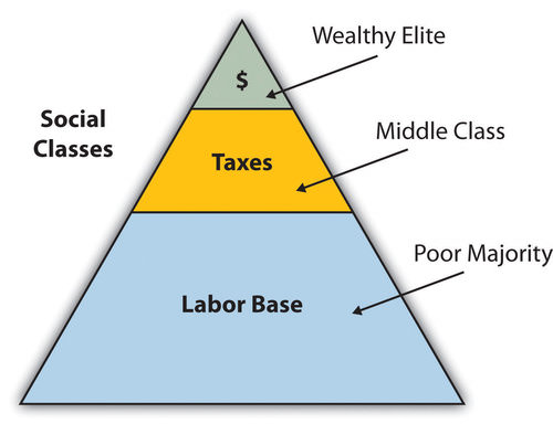
::巴西城市中心的贫民区是土地所有制、法律和秩序以及公共服务充满活力的地方。 数百万人生活在巴西大城市的棚户区。 贫困和寻找机会和优势是城市生活的共同要素。 巴西的核心城市与其他发展中的特大城市一样,同样面临着问题:过度拥挤、污染、拥堵、交通堵塞、犯罪以及社会紧张加剧。 人口、工业和商业规模产生的能源继续刺激巴西的蓬勃增长及其众多的大型、充满活力的城市。The pattern of wealth developing in Brazil is a common pattern. Wealth and the ability to obtain it are held in the hands of those at the higher end of the socioeconomic ladder. The minority wealthy elite owns most of the land and businesses, and control more than half of the wealth. Corporate colonialism is active in Brazil. Multinational corporations take advantage of the country’s development activities and benefit from the profits, which seldom reach the hands of the majority at the lower end of society.
::巴西的财富发展模式是一种共同模式。 财富和获得财富的能力掌握在社会经济阶梯较高端的人手中。 少数富裕精英拥有大部分土地和企业,控制着一半以上的财富。 公司殖民主义在巴西很活跃。 跨国公司利用国家的发展活动并从利润中获益,而利润很少落入社会下端的多数人手中。
This graphic illustrates the socioeconomic classes in Brazil.
::该图说明了巴西的社会经济阶层。
Brazil is an emerging power in the world marketplace. Brazil has the largest economy in South America and is a parallel force with the United States in the Northern Hemisphere. The country has urbanized and industrialized to compete with the global economic core areas in many ways. Brazil is among the ten largest economies in the world.
::巴西是世界市场中新兴强国,巴西是南美最大的经济体,也是北半球与美国的平行力量,巴西已经城市化和工业化,以多种方式与全球经济核心领域竞争,巴西是世界上十大经济体之一。Brazil has favorable resources and labor to compete in the global marketplace. Its agricultural output has grown substantially over the past few decades. Brazil is a major exporter of soybeans, coffee, orange juice, beef, and other agricultural products. It is the largest coffee producer in South America, but coffee only constitutes about five percent of its current annual exports. Coffee production is extensive in the Brazilian Highlands located inland from the coast. Brazil exports more orange juice than any other country and is second in the world in soybean production.
::巴西拥有有利的资源和劳动力在全球市场上竞争。 巴西的农业产量在过去几十年中大幅增长。 巴西是大豆、咖啡、橙汁、牛肉和其他农产品的主要出口国。 巴西是南美最大的咖啡生产国,但咖啡只占其目前年度出口的5%左右。 咖啡产量在巴西沿海内陆高原广泛。 巴西出口的橙汁比任何其他国家都多,在大豆生产中位居世界第二。The vast central interior regions, such as the Cerrado, continue to be developed for industrial farming of massive food crops. However, exports of industrially manufactured products have surpassed agricultural exports in 2010. The availability of abundant minerals and iron ore has supported an expanding steel industry and automotive manufacturing, and its industrial activity continues to develop. Competitive high-tech companies continue to emerge, and production has increased in semiconductors, computers, petrochemicals, aircraft, and a host of other products that provide economic growth.
::诸如塞拉多等广大中部内陆地区继续发展大规模粮食作物的工业耕作,然而,2010年工业制成品的出口超过了农业出口,丰富的矿物和铁矿石支持了钢铁工业和汽车制造业的发展,其工业活动也在继续发展。 竞争性高科技公司继续出现,半导体、计算机、石化、飞机和其他一系列能带来经济增长的产品的生产也有所增加。Brazil economically dominates and anchors South America. The economic integration being developed throughout the South American continent has great potential because it combines the energy region of the north, the commercial centers in the south, and the agricultural sectors as complementary forces within Brazil’s industrial base. Brazil is at both the physical center and the economic center of the continent.
::巴西在经济上占据主导地位,并支撑着南美。 整个南美大陆正在发展的经济一体化具有巨大的潜力,因为它将北方的能源区、南方的商业中心和农业部门作为巴西工业基地的互补力量结合在一起。 巴西位于该大陆的物理中心和经济中心。Brazil also has a strong social and cultural presence in the world. The large metropolitan areas of the country are a mecca for fashion and the arts. Carnival is the most well known of Brazil’s cultural festivals, but the country is host to a number of other international events. Brazil is active in world sports competitions and hosted the 2007 Pan American Games, the , and the . The Fédération Internationale de Football Association (International Federation of Association Football) is commonly known by the acronym FIFA and is the international governing body of soccer.
::巴西也拥有强大的社会和文化力量,巴西的大都市地区是时尚艺术的场所。 嘉年华是巴西文化节中最著名的节日,但巴西还是一些其他国际活动的主办者。 巴西积极参加世界体育竞赛,主办2007年泛美运动会、国际足球协会联合会(国际足球联合会),国际足球联合会(国际足球联合会)为国际足联(FIFA)的首字母,是国际足球管理机构。Northern Periphery: The Amazon Basin
::北周边:亚马逊流域Just as the megacities of southern Brazil anchor the core of the country, it is the rural expanse of the Amazon North that makes up the periphery. A region the size of the US Midwest, the Amazon River basin is a frontier development area that has been exploited for its natural resources. Rubber barons of early years traveled up the Amazon River and established the port city of Manaus to organize rubber plantations for automobile tires.
::正如巴西南部的特大城市成为该国核心一样,周边是北亚马逊河流域的农村地区。 亚马逊河流域是美国中西部的面积,亚马逊河流域是开发自然资源的一个边疆开发区。 早期的橡胶男爵登上亚马逊河,建立了港口城市马瑙斯(Manaus ) , 为汽车轮胎组织橡胶种植园。The Amazon River is large enough for oceangoing vessels to travel to Manaus. Today, Manaus has a free-trade zone with an entire industrial complex for the production of electronic goods and an ultramodern airport facility. Smaller ships can continue up the Amazon River all the way to Iquitos in Peru, which makes Manaus an ideal core city for economic trade.
::亚马逊河足够大,远洋船只可以前往马瑙斯。 如今,马瑙斯拥有一个自由贸易区,拥有一个生产电子货物的工业综合体和一个超现代机场设施。 小船可以一直沿着亚马逊河一直到秘鲁的伊基托斯(Iquitos ) , 这使得马瑙斯成为经济贸易的理想核心城市。
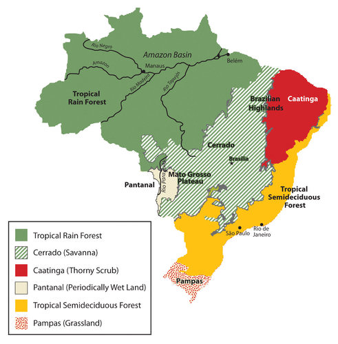
The immense area of the tropical rain forest can be seen on this map. The extensive cerrado region is noted on this map between the tropical rain forests of the Amazon Basin and the deciduous forests of the southeast. The soils of the thorny scrub region along the northeast are not as conducive to large-scale agriculture as is the cerrado.
::地图上可以看到热带雨林的巨大面积,地图上注意到亚马逊河流域热带雨林与东南部衰落的森林之间的广阔的塞拉多地区,东北部的刺青地区的土壤与塞拉多相比不利于大规模农业。
The other regions of the Amazon Basin have not been as fortunate as Manaus. Deforestation from cattle ranching, logging, and mining have devastated parts of the tropical rain forests of the Amazon Basin. The Amerindian populations have also suffered from encroachment into their lands. Only about 200,000 Amerindians are estimated to remain in Brazil, and most reside in the Amazon interior.
::亚马逊流域其他地区没有马瑙斯幸运,牧牛、伐木和采矿砍伐森林破坏了亚马逊流域部分热带雨林,美洲印第安人也遭受土地侵占,估计巴西只有大约20万美洲印第安人,大部分居住在亚马逊内地。This region boasts one of the world’s leading reserves of iron ore. As much as one-third of Europe’s iron ore demands are met through extensive mining southwest of Belém. In this area, a development scheme known as the Grande Carajás Project was implemented to create the infrastructure to support the mining complex and aid in the exploitation of the iron ore and other minerals. A large dam was built to provide hydroelectric power, and a railroad line was laid down to transport the ore to the Atlantic coast. The availability of transportation and energy attract other economic activities.
::该地区拥有世界上最大的铁矿石储量之一。 欧洲三分之一的铁矿石需求通过贝伦西南的大规模开采得以满足。 在该地区,实施了一个称为Grande Carajás项目的开发计划,以建立基础设施支持采矿综合体,并协助开采铁矿石和其他矿物。 建造了一座大坝以提供水电,并铺设了一条铁路线将铁矿石运到大西洋沿岸。 交通和能源的可用性吸引了其他经济活动。Deforestation for cattle ranching and farming has increased. Many poor settlers have arrived seeking employment opportunities or a chance to obtain land. The rapidly expanding development activities in the Amazon basin have boosted the region’s economic situation, but at the same time, there is growing concern about the preservation of the natural environment.
::许多贫穷的定居者已经到来寻找就业机会或获得土地的机会。 亚马逊流域迅速扩大的发展活动刺激了该地区的经济形势,但与此同时,人们越来越关注自然环境的保护。Gold mining, an activity that has been widespread in the Amazon region for many decades, also presents environmental problems. Toxic substances such as cyanide and mercury used in the collection of gold from rivers and streams have entered the waters and tributaries of the Amazon River. The pollutants then enter the food chain and harm the ecosystem. The mining of ores and minerals has enticed people to immigrate to the area, creating frontier boomtowns with few public utilities or social services and poorly organized law and order.
::几十年来在亚马逊地区广泛存在的黄金开采活动也带来了环境问题,诸如氰化物和用于从河流和溪流收集黄金的汞等有毒物质已进入亚马逊河水域和支流,污染物进入食物链,损害生态系统,矿石和矿物的开采诱使人们移居该地区,创建了几乎没有公共事业或社会服务、法律和秩序组织不善的边远城市。The exploitation of natural resources harms the environment and the Amerindian people. Amerindian groups have used the land as hunting grounds for centuries, but the rapid influx of gold miners and land speculators has caused conflicts with the indigenous people. Violence in the Amazon and battles for control over land and resources have been well documented.
::开采自然资源危害环境和美洲印第安人,美洲印第安人群体数世纪以来一直把土地作为狩猎地,但金矿开采者和土地投机者迅速涌入,造成了与土著人民的冲突,亚马逊地区的暴力和争夺土地和资源控制权的战斗都有详细记录。
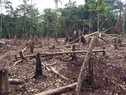
Deforestation in the Amazon is caused mainly by logging, agriculture, and mining. Agricultural practices can include slash-and-burn farming and cattle ranching.
::亚马逊地区的森林砍伐主要是伐木、农业和采矿造成的,农业做法可包括刀耕火种的耕作和牧牛。
Deforestation has reduced the habitat critical to the survival of native species. An estimated 50 percent of the earth’s species live in tropical rain forests, which only cover about five percent of the earth’s surface. Tropical rain forests in the Amazon Basin are being cut down at an unsustainable rate. Loggers cut down the large trees, and the rest are usually burned to allow the ash to provide nutrients for other plants. The cleared areas are most often used by cattle ranchers until the soil is no longer viable. Then more forest is cut down and the cycle continues. Speculation that land prices will increase as the region becomes more developed encourages this process.
::砍伐森林减少了对本地物种生存至关重要的栖息地。 据估计,50%的地球物种生活在热带雨林中,仅覆盖地球表面的5%左右。 亚马逊盆地热带雨林正在以不可持续的速度被砍伐。 伐木者砍伐了大片树木,其他树木则通常被烧为灰,为其他植物提供养分。 被清除的地区通常由牧牛人使用,直到土壤不再能够生存。 接着,更多的森林被砍伐,周期继续。 怀疑随着地区变得更加发达,土地价格将会上涨,这鼓励了这一进程。The forest has many layers of habitat. Soils in the tropics are extremely low in nutrients, which have been leached out by the abundant rainfall. The nutrients are on the surface layer of the ground built up from falling leaves, branches, and debris decomposing on the forest floor. The removal of the forests removes these nutrients and results in serious soil erosion. Tropical forests usually expand along the edges where falling debris from the trees collects and provides nutrients for young plants.
::热带地区的土壤营养物质极低,因降雨量充沛而渗出; 营养物质在地表层层,由落叶、树枝和森林地上的碎片分解而形成; 森林的清除消除了这些营养物质,导致严重的土壤侵蚀; 热带森林通常沿着树木碎片落下的边缘扩展,这些边缘收集树木碎片,为年轻植物提供营养。There is much discussion among environmentalists, scientists, and other concerned people about deforestation in the Amazon region, usually with a focus on the devastation that results from the loss of forested areas. Forest studies have indicated that tropical rain forests are resilient and can recover with proper forest management. However, clear-cutting large, wide areas for timber leaves an area devastated for an extended period. Clear-cutting could be replaced by strip cutting, which would harvest trees in narrower strips, leaving rows of trees standing. Strip cutting allows for more edges to be available for young plants to get their start to replenish the forest.
::环境学家、科学家和其他有关人士对亚马逊地区的森林砍伐问题进行了大量讨论,通常以森林丧失造成的破坏为重点。森林研究显示,热带雨林具有抗御力,可以通过适当的森林管理恢复。然而,清除大片大面积的木材林区使一个被破坏的地区长期处于荒废状态。除去干净的树木可以被脱光,在较窄的条条纹下收获树木,留下一排树木站立。切除树木可以让更多的边缘让年轻植物开始补充森林。
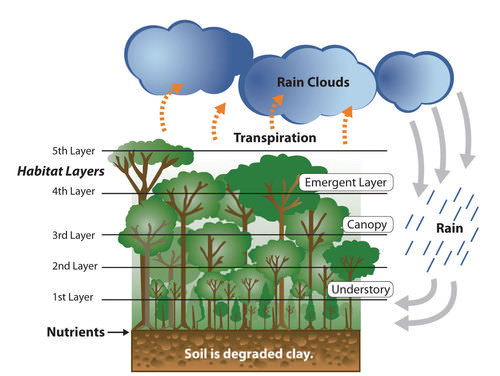
This image illustrates that the nutrients of the tropical rain forest ecosystem rest on the forest floor because tropical soils are degraded. The forest canopy has many habitat layers providing homes to a diversity of organisms. Dense tropical rain forests also contribute to the process of transpiration, which cycles precipitation from the ground back into the atmospheres where it can collect and return in the form of rain.
::这一图象表明,热带雨林生态系统的养分因热带土壤退化而留在森林底部,森林树冠有许多生境层,为各种生物提供了家园,高热带雨林也促进了蒸发过程,将降水从地面循环回大气层,以雨水的形式收集和返回大气层。
Additional forest habitat is lost when rivers are dammed up for hydroelectric power and thousands of acres of tropical rain forests are flooded. Decomposing plant material in the reservoirs behind the dams increases the water’s acidity, causing erosion to the hydroelectric turbines. The turbines have a short life span, so the dams are a short-term energy solution that creates long-term problems. The immense flooded areas reduce the habitat for tropical organisms and restrict the use of the land for other purposes. Flooding can extend into traditional hunting grounds for indigenous groups, who have little political power to restrict this type of development.
::当河流因水力发电而淹没,数千英亩热带雨林被淹没时,就会失去更多的森林生境。 水坝后面的水库中的腐蚀性植物材料增加了水的酸度,对水力发电涡轮机造成侵蚀。 涡轮机的寿命较短,因此水坝是一种短期能源解决方案,造成了长期问题。 巨大的洪涝地区减少了热带生物的栖息地,并限制了土地用于其他目的。 洪水可以扩展到土著群体的传统狩猎地,这些群体几乎没有限制这种类型的发展的政治力量。The Amazon Basin is in the midst of a development pattern in which peripheral regions are exploited for natural resources or agricultural production. Much of the wealth generated ends up in the hands of investors who live in the core cities or in other countries rather than local people, a common and recurring pattern of economic exploitation of the periphery.
::亚马逊流域处于一种发展模式之中,即边缘地区被自然资源或农业生产所剥削,大部分财富最终落入居住在核心城市或其他国家的投资者手中,而不是生活在当地人民手中,这是对边缘地区进行经济剥削的一种常见和反复出现的模式。The great frontier of the Amazon Basin continues to attract thousands of new immigrants seeking out opportunities or employment. As roads and highways are built to open up new paths through the region, even more of the forest gets cut down to accommodate the development pattern. This region will continue to be developed and altered, and the government of Brazil must continue to control its evolving dynamics in order to preserve the natural environment.
::亚马逊河流域的巨大边境继续吸引成千上万寻找机会或就业的新移民。 随着道路和公路的建设,开辟了穿过该地区的新道路,更多的森林被砍伐以适应发展模式。 该地区将继续得到发展和改变,巴西政府必须继续控制其不断演变的动态,以维护自然环境。Regional Brazil
::巴西区域区域The core-peripheral spatial relationship can help us understand the power of Brazil’s southeast core and the natural resource base of the country’s peripheral north. This can explain the basic layout of Brazil’s economic geography. However, the northeast, the west central, and the south are three additional regions that contribute to the geographic understanding of the country. Each has specific qualities that make it unique in Brazil’s diversity of landscapes.
::核心 — — 周边空间关系可以帮助我们理解巴西东南部核心的力量以及巴西周边北部的自然资源基础。 这可以解释巴西经济地理的基本布局。 然而,东北部、中西部和南部是另外三个有助于国家地理理解的地区。 每一个地区都有具体的特点,使得巴西的地貌多样性具有独特性。The northeast region is anchored along the coast, where plantation agriculture thrived during the colonial era. African slaves became the main labor base, and once freed, they made up most of the population. This agricultural region still grows sugarcane along the coast and other crops inland where the rainfall is reduced. The inland region includes parts of the Brazilian Highland, which runs parallel to the coast.
::东北地区位于海岸沿岸,在殖民时代,种植园农业蓬勃发展。 非洲奴隶成为主要劳动力基地,一旦解放,他们就占了人口的大多数。 这个农业地区仍然沿海岸种植甘蔗和雨量减少的其他作物。 内陆地区包括巴西高原的部分地区,与海岸平行。Agriculture has traditionally required a large labor base, and family sizes in rural areas have been larger than their urban counterparts. This trend has given rise to a regional population of more than 50 million. However, the agriculture-based economy has not been able to supply the number of jobs and opportunities required for this large population. Poverty and unemployment in the northeast are high and have a devastating effect on the people.
::农业历来需要庞大的劳动基础,农村地区的家庭规模比城市大,造成地区人口超过5 000万,但以农业为基础的经济无法为这个庞大的人口提供所需的就业机会和机会,东北部的贫困和失业现象十分严重,对人民造成了毁灭性影响。Some farms are not large enough for families to make a living. Individuals in the northeast have developed a pattern of migration to the larger cities of the core area looking for opportunities and employment—a pattern that fuels the favelas of Rio de Janeiro and São Paulo.
::有些农场面积不够大,无法养家糊口,东北部的个人形成了向寻求机会和就业的核心地区较大城市移徙的模式,这种模式助长了里约热内卢和圣保罗的贫民区。The west-central region has been opening up for development since the last part of the 20th century. It has experienced enormous advancements in industrial agriculture. In this region, the Cerrado grasslands are being plowed and converted into colossal fields of soybeans, grains, and cotton. Located in the northwest portion of the Cerrado is the huge Motto Grosso Plateau, which almost covers the largest state of the region. The landscape of this plateau is mainly scrub forest and savanna.
::中西部地区自20世纪后半叶开始开放发展,在工业农业方面取得了巨大进步,在这个地区,Cerrado草原被耕种并转化为大豆、谷物和棉花的巨型田。 位于塞拉多西北地区的是巨大的Motto Grosso高原,几乎覆盖了该地区最大的州。 高原的景观主要是清洗森林和稀树草原。Traditionally, the savanna has been used for grazing livestock. In recent years, more of the land is being plowed for growing agricultural crops. The entire west central region of Brazil is a giant breadbasket for the country. Its full agricultural potential has not been reached. Industrial agriculture requires infrastructure and transportation networks to transport the harvests to market. This region has enormous potential for agricultural expansion in the future.
::传统上,稀树草原一直用于放牧,近年来,更多的土地被耕种用于种植农作物,巴西整个中西部地区是巴西的一个巨大的面包篮,其农业潜力尚未充分发挥,工业农业需要基础设施和运输网络将收获运到市场,这个地区有巨大的未来农业扩张潜力。
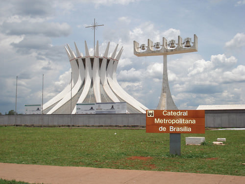
The forward capital of Brasilia, built in 1960, showcases many architectural styles.
::巴西利亚的前方首都建于1960年,展示了许多建筑风格。
Located on the eastern edge of the west central region is the capital of Brasilia. Its creation was prompted by the need to further develop the country’s interior. Built in 1960 and now a metropolitan center with more than 3.8 million people, the city was planned and designed to be a capital city. Because of its rapid growth and development, the city faces issues similar to those found in Rio de Janeiro or São Paulo.
::位于中西部地区东部边缘的巴西利亚首都是巴西利亚的首都,其创建是因为需要进一步发展国内内部。 1960年建起了一个拥有380多万人的城市中心,现在建成了一个拥有380万人的城市中心,该城市被规划成为一座首都。 由于其快速增长和发展,该城市面临着与里约热内卢或圣保罗类似的问题。Rural-to-urban shift has brought many rural people to Brasilia in search of opportunities and employment. Just as Rio de Janeiro and São Paulo have favelas, so does Brasilia. Moving the capital to Brasilia moved the focus from the coastal region of the south to the interior. However, a large percentage of the interior lies beyond the city of Brasilia. Highways that reach the Amazon can be accessed from the capital. Large areas of Brazil’s interior remain undeveloped. Developing these areas could bring great opportunities and benefits to the country. However, recent development activities have also brought devastation to the tropical rain forests in many parts of the frontier.
::农村向城市的转变使许多农村人口来到巴西利亚寻找机会和就业机会,正如里约热内卢和圣保罗有贫民窟一样,巴西利亚也有贫民窟。将首都迁到巴西利亚将重点从南部沿海地区移到内地。然而,大部分内地都位于巴西利亚市以外。通往亚马逊的公路可以从首都进入。巴西内陆大片地区仍然不发达。发展这些地区可以给国家带来巨大的机遇和好处。然而,最近的发展活动也给边境许多地区的热带雨林带来了破坏。The three states of the south region are located south of the Tropic of Capricorn and extend south to the border with Uruguay. This extrusion is often called South Brazil. Brazil was colonized by the Portuguese, but many of the immigrants to the south were from other parts of Europe, including Germany and Italy. The Italian immigrants developed a wine industry, and the German immigrants raised cattle and grew other crops.
::南部地区的三个州位于摩托热带以南,向南延伸至与乌拉圭接壤的边界,这种挤压通常称为南巴西。巴西被葡萄牙人殖民,但南部的许多移民来自欧洲其他地区,包括德国和意大利。 意大利移民发展了葡萄酒工业,德国移民养殖牛种其他作物。The region’s fertile soils and moderate climate support many types of agriculture, which have dominated the development of the region. Success in growing rice and tobacco and raising livestock has brought prosperity to the people who live here. Brazil has been one of the world’s main producers of high-quality tobacco for many years.
::该地区肥沃的土壤和温和的气候支撑着以该地区发展为主的多种农业类型。 成功地种植大米和烟草以及饲养牲畜给生活在这里的人们带来了繁荣。 巴西多年来一直是世界优质烟草的主要生产国之一。
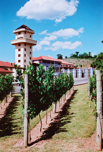
The Miolo Vineyard is located in the interior of Brazil’s affluent south region. Many Italian immigrants settled here and developed a wine industry that continues today.
::Miolo Vineyard位于巴西富裕的南部地区的内地。 许多意大利移民定居在这里,并发展了今天仍在继续的葡萄酒业。
The south is one of Brazil’s most affluent regions, and it has gained much wealth from agricultural activities. Farming is only one of the region’s highly developed economic activities. The area is also abundant with natural resources such as coal that is shipped north to the main cities where steel is produced. The wealth of the region has provided support for high-tech industries, which are attracted to the region because of the supply of skilled labor, access to quality transportation, and communication links.
::巴西南部是巴西最富裕的地区之一,它从农业活动中获得了大量财富。 农业只是该地区高度发达的经济活动之一。 该地区还拥有大量自然资源,如煤炭,向北运到生产钢铁的主要城市。 该地区的财富为高科技产业提供了支持,高科技产业由于提供熟练劳动力、获得高质量交通和通信联系而吸引了该地区。Computer companies have established software firms that have in turn attracted other new companies. A technology center similar to California’s Silicon Valley has combined with the manufacturing complex that has sprouted up along the coast of the south. The government and the business community have both provided economic incentives for these and other emerging enterprises.
::计算机公司已经建立了软件公司,这反过来吸引了其他新公司。 类似加利福尼亚硅谷的技术中心已经与南方沿岸的制造业联合起来。 政府和商界都为这些企业和其他新兴企业提供了经济激励。The attractiveness of the region in physical geography and economic stability has led some citizens to suggest that the region should separate from Brazil and become an independent country. Moreover, immigrants from poorer regions of other Brazilian states are discouraged from moving here. Poor migrants seeking opportunities are often rejected and provided transportation back to from where they came. Nevertheless, many people have migrated to the south. The region is host to immigrants from Japan and the Middle East. The progressive cities and striking environmental conditions will continue to attract people to live here.
::该地区在地理地理和经济稳定方面的吸引力使得一些公民认为该地区应该与巴西分离并成为一个独立国家。 此外,来自巴西其他州较贫困地区的移民不愿搬到这里。 寻求机会的贫困移民往往遭到拒绝,并被提供从那里返回的交通工具。 尽管如此,许多人已经迁移到南部。该地区接纳来自日本和中东的移民。进步的城市和惊人的环境条件将继续吸引人们住在这里。
The Brazilian City of Curitiba in the South
::巴西南部库里蒂巴市Brazil’s “green city” of Curitiba in the south region has been a model of urban planning that has been used in the development of cities around the world. Curitiba is a well-designed city with environmentally-friendly attitudes and green spaces. This city served as Brazil’s capital for a few days in 1969 during a transition period before the forward capital of Brasilia was built.
::巴西在南部地区的库里提巴的“绿色城市”一直是城市规划的典范,一直用于世界各地的城市发展。 库里蒂巴是一个设计完善、环境友好和绿色空间的城市。 1969年巴西利亚前方首都巴西利亚建成前的过渡期内,库里蒂巴是巴西的首都,在1969年担任了几天的巴西首都。The city is an industrial hub for southern Brazil and has diverse commercial activities—from manufacturing to financial services and tourism. Automobile manufacturing is a major part of the industrial sector and is the 2nd largest car maker in the country. The modern airport, bus system, and planned green spaces create a favorable environment for commercial ventures, which are promoted via business incubators to attract new enterprises.
::该市是巴西南部的工业枢纽,开展从制造业到金融服务和旅游业等多种商业活动,汽车制造业是工业部门的主要部分,是该国第二大汽车制造商,现代机场、公共汽车系统和规划的绿色空间为商业企业创造了有利环境,通过商业孵化器吸引新企业,促进这些企业的发展。In 2010, Curitiba had an overall metropolitan population of about 2.3 million but has used mass transit and environmental planning with great efficiency. Urban planning has helped develop a combination of streets and districts that encourage walking, bicycling, and mass transit as the main means of access. Pedestrian malls with shopping, restaurants, and services are common. More than 60 miles of bike routes allow commuters to bicycle to work.
::2010年,库里蒂巴城区人口总数约为230万,但高效地利用了大众交通和环境规划;城市规划帮助发展了鼓励步行、骑自行车和大众交通作为主要交通手段的街道和地区组合;购物、餐饮和服务的步行购物中心十分普遍;60多英里的自行车路线允许通勤者骑自行车工作。The rapid transit system, regularly used by approximately 85 percent of the people in the city, is rated as one of the best in the world. As much as 70 percent of the city’s trash is recycled, providing additional employment opportunities. At the same time that the population doubled, the use of automobiles declined by 30 percent. However, the city still has the highest rate of automobile ownership per person in Brazil.
::快速中转系统被城市中约85%的人口经常使用,被评为世界上最好的。 70%的城市垃圾被回收,提供了更多的就业机会。 与此同时,人口翻了一番,汽车的使用下降了30%。 然而,巴西的汽车拥有率仍然是巴西最高的。The decline in automobile use has had a positive effect on air quality by reducing the amount of harmful exhaust emissions. Extensive urban planning has gone into creating Curitiba as an efficient and yet progressive city. In 2010 Curitiba was awarded the Globe Sustainable City Award, which was set up to recognize cities and municipalities that excel in sustainable urban development around the world.
::汽车使用量的下降对空气质量产生了积极影响,减少了有害排气排放的数量,广泛的城市规划已经将库里蒂巴建成一个高效且进步的城市,2010年,库里蒂巴获得了全球可持续城市奖,该奖的设立是为了表彰那些在可持续城市发展中居于世界领先地位的城市和城市。The mayor of Curitiba developed a master plan for the city in 1972. One weekend, the mayor changed one of the main downtown avenues into a pedestrian-only street without announcing it to the public. At first the local businesses objected to it, but once the concept caught on, the street became one of the most actively visited parts of the downtown area.
::库里蒂巴市长于1972年为该市制定了一个总体计划,一个周末,市长将主要市区通道之一改建为一条只有行人街道,而没有向公众宣布。 起初,当地企业反对,但一旦概念被抓住,街道就成为市中心地区最受访区之一。
Key Takeaways
::密钥外出-
Brazil was a Portuguese colony during the colonial era. This is why the Portuguese language and the Catholic religion are dominant components of the Brazilian culture.
::巴西在殖民时代曾是葡萄牙殖民地,因此葡萄牙语和天主教是巴西文化的主要组成部分。 -
The strong African heritage comes from the many African slaves brought in during the colonial era to work the plantations.
::强大的非洲遗产来自殖民时代为种植园劳作而带来的许多非洲奴隶。 -
Immigrants from many other countries have settled in Brazil as well.
::来自许多其他国家的移民也在巴西定居。 -
The urban southeast, with its large cities of São Paulo and Rio de Janeiro, represents the core economic area of the country.
::东南部城市,加上圣保罗和里约热内卢这两个大城市,是该国的核心经济地区。 -
The large cities of Brazil continue to expand to accommodate the influx of new immigrants.
::巴西大城市继续扩大,以容纳新移民的涌入。 -
The outer edges of the cities expand through slums called favelas.
::城市的外缘通过贫民窟扩大,称为贫民区。 -
The northern regions of the Amazon Basin represent the periphery of the country. The north is being exploited for its natural resources.
::亚马逊河流域北部地区是国家的外围地区,北方正在被开采自然资源。 -
Development patterns have caused extensive deforestation of the tropical rain forest of the region. The main causes are agriculture, logging, and mining.
::发展模式导致该区域热带雨林大量砍伐森林,主要原因是农业、伐木和采矿。 -
Other regions of Brazil include the west central, with extensive agricultural activities; the northeast, heavily populated with serious poverty; and the south in the protruded area bordering Uruguay, which is an affluent region with high standards of living.
::巴西其他地区包括中西部地区,开展广泛的农业活动;东北地区,人口严重贫穷;南部,与乌拉圭接壤的蓬勃地区,乌拉圭是一个富裕地区,生活水平高。
Vocabulary Terms
::词汇术语术语Chapter 4.7 Brazil
::第4.7章 巴西d eforestation
::毁林The cutting down or destroying of large areas of forest
::砍伐或摧毁大片森林f avela
::贫民窟Slum area
::贫民区slash and burn agriculture
::砍刀和燃烧的农业a farming technique in which trees are cut down and burned to clear and fertilize the land
::一种耕作技术,砍树砍树烧火,以清除土地并施肥Applying Knowledge
::应用知识Interactive Notebook Activity
::交互式笔记活动-
Summarize
the ethnic composition of Brazil.
Describe
why the population is so diverse.
::概述巴西的种族组成,说明为什么人口如此多样化。 -
Explain
how the core-periphery spatial relationship applies to the country.
::解释核心-周边空间关系如何适用于国家。 -
Explain
how the dynamics of the country shape the core and the periphery.
::解释国家动态如何决定核心和外围。 -
Describe
the main activities that are involved in the development and exploitation of the Amazon Basin.
::说明参与亚马孙流域开发和开发的主要活动。 -
Describe
how deforestation affects the tropical rain forest and environmental conditions.
::说明毁林如何影响热带雨林和环境条件。 -
List
the main characteristics and economic activities of the main regions of Brazil.
::列出巴西主要区域的主要特点和经济活动。
Discussion and Study Questions
::讨论和研究问题-
Explain the Atlantic Trade Triangle. How did it operate? How was Brazil involved?
::解释一下大西洋贸易三角,它是如何运作的?巴西是如何参与的? -
Where is Brazil’s core region? Where is its peripheral region? What are its core cities?
::巴西的核心区域在哪里?其外围区域在哪里?核心城市是什么? -
What three cities make up Brazil’s political capital, cultural capital, and largest city?
::巴西的政治首都、文化首都和最大城市由哪些三个城市组成? -
What is a forward capital and why does Brazil have one? Are favelas located in the forward capital?
::什么是前方资本,为什么巴西有前方资本? 贫民窟是否位于前方首都? -
Why is Manaus such a core city for its region? What makes it so attractive to economic development?
::为什么马瑙斯是本区域的核心城市?它为什么对经济发展如此有吸引力? -
What are the main causes of deforestation in the Amazon Basin? How can deforestation be reduced?
::亚马逊流域砍伐森林的主要原因是什么?如何减少砍伐森林? -
What is the economic situation in the northeast? How are people attempting to remedy the economic situation?
::东北部的经济形势如何?人们如何试图纠正经济形势? -
What is promising about the west-central region of Brazil? What is needed to develop the area?
::巴西中西部地区的前景如何? -
Why is the south region so affluent? What is this region doing to attract economic development?
::为什么南部地区如此富裕? 该地区为吸引经济发展做了哪些工作? -
How has the rural-to-urban shift been evident in the population of Brazil? Where has it been occurring?
::巴西人口从农村向城市的转变如何明显?这种转变在哪里发生的?
Real-World Geography Exercise
::现实世界地理演习Using , locate the places below. Approximately how many miles is it from your house to each location? Go to and find the air pollution index for each of the cities. How do you think the pollution from the cities impacts the environment in the different regions of Brazil? Be prepared to share your answers.
::使用 , 定位下面的位置 。 大约从你家到每个位置的英里是多少? 去寻找每个城市的空气污染指数 。 您认为城市污染如何影响巴西不同地区的环境? 准备分享您的答案 。Cities
::城市城市城市-
Belém
::贝伦 -
Brasilia
::巴西利亚 -
Curitiba
::库里蒂巴 -
Manaus
::马瑙斯 -
Rio de Janeiro
::里约热内卢 -
Salvador
::萨尔瓦多 萨尔瓦多 -
São Paulo
::圣保罗
Regions of Brazil
::巴西地区-
North
::北部 -
Northeast
::东北 -
South
::南南 -
Southeast
::东南 -
West central
::西中西部
Physical Regions
::物理区域-
Amazon Basin
::亚马逊流域 -
Brazilian Highlands
::巴西高地 -
Cerrado
::塞拉多 -
Mato Grosso Plateau
::马托格罗索高原
Mapping Exercise
::绘图绘制作业ESRI-GEO Inquiry
::ESRI-全球环境展望调查: Students will explore the spatial patterns of the Human Development Index (HDI) to identify regional patterns and causal factors in the data. The activity uses a web-based map.Videos for Geography Enrichment
::地理丰富视频Helpful Websites for the Study of Geography
::地理研究有用网站is an encyclopedia funded by the Canadian government covering all branches of knowledge. Their scholarly collection includes interactive materials.
::该百科全书由加拿大政府资助,涵盖所有知识分支,其学术收藏包括交互式材料。provides information on the people, history, government, economy, energy, geography, communications, transportation, military, and transnational issues for the world's entities.
::向世界各实体提供关于人民、历史、政府、经济、能源、地理、通信、运输、军事和跨国问题的资料。is a US government website where you can find federal legislation, past and present, as well as information about the US legal system.
::是一个美国政府的网站,您可以在此找到过去和现在的联邦立法以及关于美国法律制度的信息。is a government agency website that provides current news, resources, topics of interest, information about drugs, careers in the DEA, and a tip hotline.
::是一个政府机构网站,提供最新消息、资源、感兴趣的话题、毒品信息、在缉毒局的职业以及一条小费热线。is the largest library in the world and provides manuscripts, files, information, pictures, and videos.
::图书馆是世界上最大的图书馆,提供手稿、文件、信息、图片和录像。is a US government agency website that allows users to search for and retrieve satellite images of Earth.
::这是一个美国政府机构的网站,用户可以搜索和检索地球的卫星图像。is a US government website that provides historical documents, photos, records, publications, and educator resources.
::这是一个美国政府网站,提供历史文件、照片、记录、出版物和教育资源。is a US government agency website that provides weather-related information and ocean research.
::是一个提供气象信息和海洋研究的美国政府机构网站。is a website by the United States Geological Survey and other federal, state, and local agencies that delivers topographic information for the United States.
::这是美国地质调查局和其他联邦、州和地方机构为美国提供地形信息的网站。is a massive central data source and a handy way to graphically compare nations.
::是一个庞大的中央数据源,是用图形比较国家的一种方便方式。is a website that measures most locations in the world for air pollution in real time.
::是一个实时测量世界上大多数空气污染地点的网站。is a unique statistical database, which allows you to research and compare a multitude of different data on US states.
::这是一个独特的统计数据库, 使你能够研究和比较关于美国各州的多种不同数据。is an international organization founded in 1945 and made up of 193 member states. The UN maintains international peace and security, protects human rights, delivers humanitarian aid, promotes sustainable development, and upholds international law.
::联合国是一个国际组织,成立于1945年,由193个成员国组成。 联合国维护国际和平与安全,保护人权,提供人道主义援助,促进可持续发展,维护国际法。is a US government agency that provides a population clock, data, surveys, statistics, a library with information and infographics, news about the economy, and much more.
::这是一个美国政府机构,它提供人口钟、数据、调查、统计、一个拥有信息和信息资料的图书馆、关于经济的新闻,以及更多。is a US government agency website that provides scientific information about the natural hazards that threaten lives, the natural resources we rely on, the health of our ecosystems and environment, and the impacts of climate and land-use change.
::这是一个美国政府机构的网站,提供科学信息,说明威胁生命的自然危害、我们赖以生存的自然资源、生态系统和环境的健康以及气候和土地使用变化的影响。is a US government website that provides the latest presidential news, information about the budget, policy, defense, and many more topics.
::提供最新总统新闻、预算、政策、国防等资讯, 以及更多议题。is under the United Nations and provides leadership on matters critical to health; shapes the research agenda on health; and monitors the health situation and assessing health trends around the world. Their website provides information on the state of health around the world, outbreaks, current health news, and more.
::他们的网站提供世界各地卫生状况、疫情爆发、最新卫生新闻等信息。is an intergovernmental organization that regulates international trade. The website provides information on the history of the multilateral trading system, featured videos, news and events, trade topics, and more.
::该网站提供关于多边贸易体系历史的信息、视频、新闻和事件、贸易专题等等。 -
Summarize briefly the ethnic composition of Brazil and describe why the population is so diverse.