4.8 南美洲:南锥体(1天)
章节大纲
-
Chapter Challenges
::章次 挑战-
List the main physical features and regions of the Southern Cone.
::列出南锥体的主要物理特征和地区。 -
Describe the location of the urban centers and explain the pattern of population distribution in the three countries of the region.
::说明城市中心的位置,并解释该区域三个国家的人口分布模式。 -
Describe the ethnic consistency of each country.
::说明每个国家的种族一致性。 -
Explain the pattern of immigration that created the region’s heritage.
::解释造成该地区遗产的移民模式。 -
Explain why Argentina has great potential for economic growth.
::解释为什么阿根廷有巨大的经济增长潜力。 -
Summarize briefly how Chile has emerged as a strong and stable country and discuss its human and natural resources.
::简要总结一下智利如何成为一个强大和稳定的国家,并讨论其人力资源和自然资源。
Student Learning Objectives
::学生学习目标TEKS Regional World Geography Unit 05 Latin America Chapter 4.8 South America: The Southern Cone
::TEKS 区域世界地理股05 拉丁美洲 南美洲:南锥体WG.3B Describe the physical processes that affect the environments of regions, including weather, tectonic forces, erosion, and soil-building processes.
::WG.3B 描述影响区域环境的物理过程,包括天气、构造力、侵蚀和土壤建设过程。WG.4B Explain how elevation, latitude, wind systems, ocean currents, position on a continent, and mountain barriers influence temperature, precipitation, and distribution of climate regions.
::WG.4B 解释高海拔、纬度、风力系统、洋流、大陆位置、山地屏障如何影响气候区域的温度、降水量和分布。WG.6A Locate and describe human and physical features that influence the size and distribution of settlements.
::WG.6A 确定并描述影响定居点规模和分布的人文和物理特征。WG.9A Identify physical and/or human factors such as climate, vegetation, language, trade networks, political units, river systems, and religion that constitute a region.
::WG.9A 查明构成区域的自然和/或人类因素,如气候、植被、语言、贸易网络、政治单位、河流系统和宗教。WG.11A Understand the connections between levels of development and economic activities (primary, secondary, tertiary, and quaternary).
::WG.11A 了解发展水平与经济活动(初等、中等、高等教育和四年级)之间的联系。WG.11B Identify the factors affecting the location of different types of economic activities, including subsistence and commercial agriculture, manufacturing, and service industries.
::WG.11B 查明影响不同类型经济活动地点的因素,包括生计和商业农业、制造业和服务业。WG.12A Analyze how the creation, distribution, and management of key natural resources affects the location and patterns of movement of products, money, and people.
::WG.12A 分析关键自然资源的创造、分配和管理如何影响产品、货币和人员流动的地点和模式。WG.12B Evaluate the geographic and economic impact of policies related to the development, use, and scarcity of natural resources such as regulations of water.
::WG.12B 评价与自然资源开发、使用和稀缺有关的政策的地理和经济影响,如水管理条例。WG.13A Interpret maps to explain the division of land, including man-made and natural borders, into separate political units such as cities, states, or countries.
::WG.13A 解释地图,解释土地划分,包括人造边界和自然边界,分为不同的政治单位,如城市、州或国家。WG.16B Describe elements of culture, including language, religion, beliefs and customs, institutions, and technologies.
::WG.16B 描述文化要素,包括语言、宗教、信仰和习俗、机构和技术。WG.17A Describe and compare patterns of culture such as language, religion, land use, education, and customs that make specific regions of the world distinctive.
::WG.17A 描述和比较使世界特定区域具有独特性的语言、宗教、土地使用、教育和习俗等文化模式。WG.21A Analyze and evaluate the validity and utility of multiple sources of geographic information such as primary and secondary sources, aerial photographs, and maps.
::WG.21A 分析和评价多种地理资料来源,例如主要和次要资料来源、航空照片和地图的有效性和效用。WG.22A Design and draw appropriate graphics such as maps, diagrams, tables, and graphs to communicate geographic features, distributions, and relationships. features, distributions, and relationships.
::WG.22A 设计和绘制适当的图形,如地图、图表、表格和图表,以交流地理特征、分布和关系、特征、分布和关系。WG.22C Use geographic terminology correctly.
::WG.22C 正确使用地理术语。WG.22D Use standard grammar, spelling, sentence structure, and punctuation.
::WG.22D 使用标准语法、拼写、句子结构和标点。South America: The Southern Cone
::南美洲:南锥体Overview of the Region
::区域概况The Southern Cone region of South America includes the countries of , , and . The name is an indication of the physical shape of the southern portion of the continent. The region is located south of the tropics. The Tropic of Capricorn runs just north of Uruguay and cuts across the northern regions of Argentina and Chile. The Southern Cone has more moderate temperatures than the tropics.
::南美洲南锥体区域包括...、...和...的国家。这个名称表示着大陆南部的物理形状。这个区域位于热带以南,摩角的热带横跨阿根廷和智利的北部地区,横跨乌拉圭北部。南锥体的温度比热带要温和。Type C climates dominate in Uruguay, the Pampas region of Argentina, and central Chile. The region has extremes in weather and climate. The Atacama Desert and Patagonia both have type B climates because of a lack of precipitation, which stems from the rain shadow effect of the Andes Mountains. Highland type H climates follow the Andes chain through the region and exhibit their typical pattern of warmer temperatures at lower elevations and colder temperatures at higher elevations.
::C型气候在乌拉圭、阿根廷的潘帕斯地区和智利中部占主导地位,在天气和气候方面最为极端,阿塔卡马沙漠和帕塔哥尼亚地区都缺乏B型气候,原因是安第斯山脉的雨影效应导致降水量减少,高地H型气候沿着安第斯山脉链穿过该地区,展示了低海拔温和高海拔低温温的典型模式。
The Three Main Regions of Chile (left); Argentina and Uruguay with the Regions of Argentina Outlined and Labeled (right).
::智利三个主要地区(左);阿根廷和乌拉圭,阿根廷大区和阿根廷大区(右区)。
The countries of the Southern Cone share similar economic and ethnic patterns. Agriculture has been a major focus of the region’s early development pattern, but today a large percentage of the population is urbanized. The European heritage of most of the population ties this region to Europe as an early trading partner. The global economy has given cause for these countries to form trade relationships with many countries. The physical geography has provided many opportunities for human activities.
::南锥体国家有着类似的经济和种族模式。 农业一直是该地区早期发展模式的一个主要焦点,但如今,很大一部分人口已经城市化。 大部分人口的欧洲遗产将该地区作为早期贸易伙伴与欧洲联系在一起。 全球经济为这些国家与许多国家建立贸易关系提供了原因。 自然地理为人类活动提供了许多机会。The mountains, plains, and coastal areas provide a diversity of natural resources that have been exploited for national wealth. All three countries have primate cities that hold a high percentage of the country’s population. Primate cities are usually twice as large as the next largest city and usually are expressive of the national feeling and culture. In this case, all three primate cities are also the capital cities of each country. The Southern Cone is an urban region with higher incomes and higher standards of living than many other parts of South America.
::山区、平原和沿海地区提供了多种多样的自然资源,这些自然资源已被开发用于国家财富。 这三个国家都有占全国人口高比例的灵长类城市。 原始城市通常比下一个最大的城市大一倍,并且通常能表达国家的感觉和文化。 在这种情况下,所有三个灵长类城市都是每个国家的首府城市。 南锥体是一个收入和生活水平都高于南美洲其他许多地区的城市地区。Uruguay
::乌拉圭
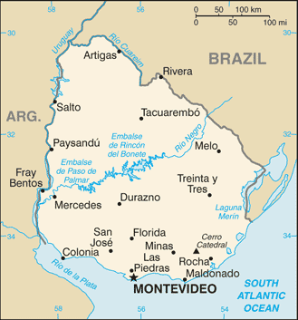
Map of Uruguay
::乌拉圭地图
is located along the South Atlantic coast bordering Argentina and Brazil. The only South American country smaller in physical area is Suriname. French Guiana is also smaller than Uruguay but remains a department of France. Uruguay has the location, natural resources, and global trade connections to provide ample opportunities and advantages for its people. The agricultural lands of the Pampas extend into Uruguay and provide for an extensive agricultural industry with livestock, small grains, vegetables, and dairy. This agricultural base has been the foundation of Uruguay’s growing economy.
::南大西洋沿岸与阿根廷和巴西接壤,唯一面积较小的南美国家是苏里南。法属圭亚那也比乌拉圭小,但仍然是法国的一个部门。乌拉圭拥有为人民提供充足机会和优势的地理位置、自然资源和全球贸易联系。 潘帕斯的农业用地延伸到乌拉圭,提供大量农牧业、小谷物、蔬菜和奶制品。 这一农业基地是乌拉圭经济增长的基础。Uruguay has been able to integrate itself into the global trade arena and has entered into a postindustrial development status. Postindustrial activities have included computer software development and advancements in information technologies. Uruguay is a modern and well-developed country. About 88 percent of the population is of European descent, and more than 92 percent of the population is urban. The capital city of Montevideo, a cosmopolitan city with a population of about 3.5 million, is home to about 40 percent of the population. The coastal region is an attractive place for tourists and locals who enjoy the beautiful beaches along the shores of the Atlantic.
::乌拉圭已经能够融入全球贸易领域,并进入了工业后发展阶段,工业后活动包括计算机软件开发和信息技术的进步,乌拉圭是一个现代和发达的国家,大约88%的人口是欧洲后裔,92%的人口是城市人口,蒙得维的亚是一个拥有大约350万人口的大城市,大约40%的人口居住在首都蒙得维的亚,沿海地区对游客和享受大西洋沿岸美丽海滩的当地人来说是一个有吸引力的地方。
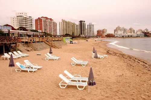
Notice the high-rise apartments and commercial buildings. Uruguay is highly urbanized and has been an attractive place for tourism.
::乌拉圭高度城市化,对旅游业具有吸引力。
Montevideo is also the location of the headquarters for Mercosur (the Southern Cone Common Market). Mercosur was created in 1991 to open trade of goods and services among South American countries and promote development within the realm. Current members of Mercosur include Uruguay, Paraguay, Brazil, and Argentina. Venezuela’s application for full membership is pending. Additional associate members of Mercosur include Peru, Ecuador, Colombia, Chile, and Bolivia. Mercosur is on a parallel path to compete with , , the , and other global trade associations.
::蒙得维的亚也是南方共同市场(南锥体共同市场)总部所在地。 南锥体共同市场成立于1991年,目的是开放南美洲国家间的货物和服务贸易,促进本领域内的发展。 南锥体共同市场目前的成员国包括乌拉圭、巴拉圭、巴西和阿根廷。 委内瑞拉的正式成员资格申请正在等待批准。 南锥体共同市场的其他准成员国包括秘鲁、厄瓜多尔、哥伦比亚、智利和玻利维亚。 南锥体共同市场正与南美国家和其他全球贸易协会平行竞争。Argentina
::阿根廷 阿根廷 阿根廷
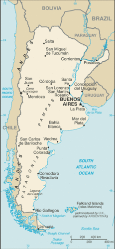
Map of Argentina
::阿根廷地图地图
South America’s second-largest country is Argentina. In physical area, Argentina is ranked eighth in the world. The Andes Mountains span its entire western border with Chile. At the southern end of the continent is Tierra del Fuego. Argentina is a land of extremes. Mount Aconcagua is the highest mountain in the Western Hemisphere at 22,841 feet in elevation. Laguna del Carbon is the lowest point in the Western Hemisphere at −344 feet below sea level. Parts of the northern region have a tropical climate.
::南美洲第二大国家是阿根廷,在地理面积方面,阿根廷位居世界第八。安第斯山脉横跨与智利接壤的整个西部边界。在大陆的南端是火地岛。阿根廷是一片极端之地。阿康卡瓜山是西半球最高的山,海拔为22 841英尺。拉古纳德尔碳是西半球最低点,海拔低于344英尺。北部地区部分地区有热带气候。The southern region extends into tundra-like conditions with treeless plains. Argentina also claims the Falkland Islands, which are now controlled by Great Britain. In 1982, Argentina’s ruling military junta attempted to retake control of the Falklands, but the British navy halted the action in what became known as the .
::南部地区与无树平原相类似。 阿根廷也拥有福克兰群岛,而福克兰群岛现在由英国控制。 1982年,阿根廷执政的军政府试图夺回福克兰群岛的控制权,但英国海军却停止了所谓的福克兰群岛的行动。Physical Regions
::物理区域Argentina can be categorized into a number of regions that correlate roughly with the varied physical and cultural landscapes of the country. The main regions include Chaco, Northern, Mesopotamia, Cuyo, Pampas, and Patagonia. The Northern region of Argentina has one of the highest average elevations because of the Andes Mountain range. The Andes range widen as they proceed northward to the west of Chaco and are home to fertile river valleys. The northern ends of the ranges extend into Bolivia and enter the Altiplano of the Central Andes.
::阿根廷可划分为与该国各种自然和文化景观大致相关的若干地区,主要地区包括查科、北方、美索不达米亚、库约、潘帕斯和巴塔哥尼亚,阿根廷北部地区因安第斯山脉的分布范围而成为最高平均海拔之一,安第斯山脉向北延伸至查科以西,并拥有肥沃的河谷,山脉的北端延伸至玻利维亚,进入安第斯中部阿尔蒂普拉诺。The Chaco region extends from northern Argentina into western Paraguay. Scrublands and subtropical forests dominate the landscape. There is a wet season as well as a dry season suitable for raising livestock and some farming. Western Chaco, which is closer to the Andes, is drier with less vegetation and is known for its high temperatures during the summer months. To the east, the Chaco region receives more rainfall and has better soils for agriculture.
::查科地区从阿根廷北部延伸到巴拉圭西部,灌木林和亚热带森林占地势,有一个适合饲养牲畜和一些农耕的湿季和旱季,西查科地区靠近安第斯山脉,植被干燥,夏季几个月以高温闻名,东部的查科地区降雨量更多,农用土壤更好。The agrarian lifestyle dominates the cultural heritage of this region. In the 1920s and 1930s, the Chaco region attracted a large number of Mennonite immigrants from Canada and Russia who established successful farming operations mainly on the Paraguay side of the border and also extending into Argentina.
::1920年代和1930年代,查科地区吸引了大量来自加拿大和俄罗斯的门诺派移民,他们主要在边界的巴拉圭一侧成功地开展耕作活动,并扩大到阿根廷。To the east of the northern region—on the other side of the Paraná River and reaching to the banks of the Uruguay River—is the region called Mesopotamia, whose name means “between rivers.” This unique region has a variety of features, from flatlands for grazing livestock to subtropical rain forests. The most noteworthy feature is the expansive Iguazú Falls on the Iguazú River, located on the border of Brazil and Argentina. It is a series of 275 parallel waterfalls that are almost two miles across. It has the greatest average annual flow of any waterfall in the world. Most of the falls are more than 210 feet high, and the tallest is 269 feet. The spectacular Iguazú Falls is a major tourist attraction, drawing people from all over the world.
::北部以东——巴拉那河的另一边,通向乌拉圭河岸——是称为美索不达米亚的地区,其名称指 " 河流之间 " 。 这个独特的区域有各种各样的特点,从放牧的平地到亚热带雨林,最值得注意的特点是位于巴西和阿根廷边界的伊瓜苏河上的广阔的伊瓜苏瀑布,这是一系列275个平行瀑布,几乎相隔两英里,是世界上任何瀑布的年平均流量最大,大多数瀑布都超过210英尺,最高的是269英尺,壮观的伊瓜苏瀑布是吸引世界各地人民的大型旅游景点。
The headwaters of the Iguazú River are near Curitiba in Brazil. The river converges with the Paraná River about 14 miles downstream from the Iguazú Falls at the point where Brazil, Paraguay, and Argentina meet—called the Triple Frontier. The falls is approximately 1.7 miles along its edge, which is divided by rocky islands on both the Argentinean and Brazilian sides. The Iguazú Falls is a major tourist attraction for the region.
::Iguazú河头水在巴西库里蒂巴附近,该河与巴拉那河汇合,离伊瓜苏瀑布下游约14英里,巴西、巴拉圭和阿根廷相遇时称为 " 三边疆界 " ,其边缘大约为1.7英里,阿根廷和巴西两边都是岩石岛屿,伊瓜苏瀑布是该区域的主要旅游景点。
The Cuyo region is located along the Andes Mountains in the west-central part of the country. Mount Aconcagua is located here, along with other high mountain peaks. This arid region gets most of its moisture from melting snow off the mountains. This melting snow irrigates the rich agricultural lands that produce fruits and vegetables.
::Cuyo地区位于该国中西部的安第斯山脉沿线,Aconcagua山和其他高山峰都位于这里,这个干旱地区大部分水分来自山上的融雪,这种融雪使生产水果和蔬菜的肥沃农地受到灌溉。The Cuyo is a major wine-producing region. It accounts for up to three-quarters of the country’s wine production. Picturesque vineyards and farms make the Cuyo a favorite tourist destination in Argentina. Mendoza is the country’s fourth largest city. Low mountain ranges form the eastern border between the Cuyo and the Pampas.
::库约是一个主要的葡萄酒生产区,占全国葡萄酒生产量的四分之三。 图片葡萄园和农场使库约成为阿根廷最喜爱的旅游目的地。 门多萨是阿根廷第四大城市。 低山山脉构成了库约和潘帕斯之间的东部边界。The Pampas is a large agricultural region that extends beyond Argentina and includes a large portion of Uruguay and the southern tip of Brazil. With adequate precipitation and a mild type C climate, the Pampas is well-suited for both agriculture and human habitation. The rich agricultural lands of the Pampas include the largest city and the country’s capital, Buenos Aires. Buenos Aires is home to approximately one-third of the nation’s population. The Pampas provides some of the most abundant agricultural production on the planet. The western grasslands host large haciendas with cattle ranching and livestock production.
::Pampas是一个大农业区,面积超过阿根廷,包括乌拉圭和巴西南端的很大一部分。由于降雨量充足,气候温和,Pampas地区既适合农业,又适合人类居住。Pampas地区的肥沃农田包括全国最大的城市和首都布宜诺斯艾利斯。布宜诺斯艾利斯是全国人口大约三分之一的家园。Pampas地区提供了地球上最丰富的农业生产。西部草原拥有大片庄园,畜牧和畜牧生产。This area has elevated Argentina to its status as a major exporter of beef around the world. Agricultural production has been a major part of the nation’s economy. One hundred years ago, the export of food products made Argentina one of the wealthiest countries in the world. In today’s global economy, the profit margins in agricultural products are not as lucrative, and industrialized countries have turned to manufacturing for national wealth. Argentina continues to have a strong agricultural sector but has been increasing its industrial production in order to secure a strong economy.
::农业是阿根廷经济的主要部分。 一百年前,食品出口使阿根廷成为世界上最富有的国家之一。 在今天的全球经济中,农产品的利润率不那么高,而工业化国家则转而转向制造国家财富。 阿根廷继续拥有强大的农业部门,但为了获得强大的经济,它一直在增加工业生产。
The rain shadow effect in southern South America creates the Atacama Desert and an arid Patagonia.
::南美南部的雨影效应 创造了阿塔卡马沙漠 和干旱的巴塔哥尼亚
Patagonia is a large expanse of the south that is semiarid because of the rain shadow effect. This area possesses enormous natural resources, including large amounts of oil and natural gas. Deposits of gold, silver, copper, and coal can be found here. Raising livestock has been the main livelihood in Patagonia, which is otherwise sparsely populated. Patagonia includes the southern region of Tierra del Fuego and the rugged Southern Andes.
::帕塔哥尼亚是南部的大片土地,由于雨影效应而半干旱,该地区拥有巨大的自然资源,包括大量的石油和天然气,这里可以找到金、银、铜和煤的矿藏。 饲养牲畜一直是巴塔哥尼亚的主要生计,而巴塔哥尼亚本来人口稀少,帕塔哥尼亚包括南火地岛和南安第斯山脉。This region has some of the largest ice sheets outside Antarctica and many large glaciers that provide fresh water that feeds the region’s streams and rivers. Patagonia also has a number of scenic lakes. Abundant wildlife can be found along the Atlantic coast, including elephant seals, penguins, albatrosses, and a host of other species. This region demonstrates that Argentina is abundant with a variety of physical landscapes and natural resources that can help support its economy.
::该地区有南极洲以外的一些最大的冰层和许多提供淡水供养该地区河流和河流的大型冰川。 巴塔哥尼亚也有许多风景湖泊。 大西洋沿岸可以发现大量野生动物,包括大象海豹、企鹅、信天翁和其他物种。 该地区表明阿根廷拥有丰富的自然景观和自然资源,可以支持其经济。Population and Culture
::人口与文化Argentina, with a population of about 40 million, is a country of immigrants and a product of the colonial transfer of European culture to the Western Hemisphere. During the colonial era, millions of people immigrated to Argentina from Western European countries such as France, Germany, Switzerland, Portugal, Greece, the British Isles, and Scandinavia. Additional immigrants came from Eastern Europe and Russia.
::阿根廷人口约4 000万,是一个移民国家,是欧洲文化向西半球殖民转移的产物。 在殖民时代,数百万人从法国、德国、瑞士、葡萄牙、希腊、不列颠群岛和斯堪的纳维亚等西欧国家移民到阿根廷。 更多的移民来自东欧和俄罗斯。Eighty-five percent of the population is of European descent. The largest ethnic groups are Spanish and Italian. The Mestizo population is about eight percent. A small number of people from the Middle East or East Asia have immigrated and make up about four percent of the population. Less than two percent of Argentines declare themselves to be Amerindians.
::85%的人口是欧洲后裔,最大的族裔群体是西班牙人和意大利人,梅斯蒂索人约占8%,来自中东或东亚的少数人口移民,约占人口的4%,不到2%的阿根廷人宣称自己是美洲印第安人。Old World European customs mix with New World Latin American traditions to form a cultural heritage unique to Argentina. This cultural heritage can be experienced in the metropolitan city of Buenos Aires, where all facets of society and culture can be found. With a population of about 13 million—one-third of Argentina’s total population—Buenos Aires is a world-class city. Argentina is an urban country with more than 90 percent of the population living in cities.
::旧世界欧洲习俗与新世界拉丁美洲传统混合,形成了阿根廷独有的文化遗产。 这种文化遗产可以存在于布宜诺斯艾利斯市,那里可以找到社会和文化的各个方面。 人口约为1300万 — — 阿根廷总人口的三分之一 — — 布宜诺斯艾利斯是一个世界级城市。 阿根廷是一个城市国家,90%以上的人口生活在城市。The rural side of the culture has often been characterized as the traditional gaucho image of the self-reliant rancher who herds cattle and lives off the land. Beef is a mainstay of the cuisine in much of the country. The urban culture includes the traditional Argentine tango with music and camaraderie in upscale night clubs. These traditional images may be stereotypes, but the cultural scene in Argentina is heavily invested in the international trends of the modern world. The cultural landscape has become integrated with fashions and trends from across the globe.
::农村文化往往被描述为自食其力的牧牛人的传统乡下形象。牛肉是该国大部分地方烹饪的支柱。城市文化包括传统的阿根廷探戈和音乐以及高级夜总会的友爱。这些传统形象可能是陈规定型的,但阿根廷的文化场景对现代世界的国际趋势投入了大量资金。文化景观已经与世界各地的时尚和趋势融为一体。
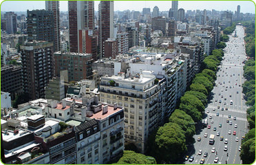
This photo illustrates the enormous expanse of the most populous area of Buenos Aires, Argentina.
::这张照片说明了阿根廷布宜诺斯艾利斯人口最多地区的广阔面积。People and Politics
::人民与政治The people of Argentina have a high standard of living, and the country is up-and-coming on a world scale. The main problem has been the instability of the government during the 20th century. The Argentine constitution provides for a balance of powers between the judicial, legislative, and executive divisions, similar to that of the United States. For many decades in the 20th century, the state vacillated between a democratically elected government and military rule. The swings back and forth have been consistent and regular, which has wreaked havoc on the economy, resulting in everything from hyperinflation to brutal authoritarian rule.
::阿根廷人民生活水平很高,国家正在世界范围内崛起,主要问题是20世纪政府不稳定。阿根廷宪法规定司法、立法和行政部门之间的权力平衡,与美国相似。 20世纪数十年来,阿根廷在民主选举产生的政府和军事统治之间徘徊不前。 国家前后摇摆,对经济造成严重破坏,导致从恶性通膨胀到残暴的专制统治等一切结果。An example of the national swings in Argentina occurred between 1946 and 1955 when General Juan Perón was elected president. His wife, Eva, became a public sensation. “Peronism” started out with populous support and a shift toward improving working conditions and increasing government spending. At the same time, censorship, isolationism, and repression of civil rights were elevated to a point of social unrest. Opposition members were imprisoned or killed.
::1946年至1955年,阿根廷发生国家摇摆的例子之一,当时胡安·佩隆将军当选为总统。 其妻子伊娃(Eva)成为公众的感官。 “时代主义 ” 始于人口众多的支持,转向改善工作条件和增加政府支出。 与此同时,审查、孤立主义和镇压公民权利被提升到社会动乱的地步。 反对党成员被囚禁或杀害。Eva Perón died of cancer in 1952, and Juan Perón was eventually ousted from office and fled to Spain. He later returned from exile to gain prominence in politics once again but died in office in 1974. Other presidents came to power only to be deposed or ousted by military coups. The instability in the political arena created problems for the economic sector, which had to deal with inflated currency and an unattractive environment for foreign investments.
::埃娃·佩隆死于1952年的癌症,胡安·佩隆最终被撤职并逃往西班牙。 后来他从流亡中再次回到西班牙,在政治中占据重要地位,但于1974年去世。 其他总统上台只是为了被军事政变推翻或推翻。 政治舞台上的不稳定给经济部门造成了问题,因为经济部门不得不应对货币膨胀和外国投资环境不吸引人的问题。More recently, there has been some progress in stabilizing both the government and the economy, but political instability remains a factor. Argentina has abundant natural resources, adequate infrastructure, and an educated workforce. The country has all the necessary means to launch into the future with a strong economy—as long as it is able to establish a stable government and a sound economic agenda.
::最近,阿根廷在稳定政府和经济方面取得了一些进展,但政治不稳定仍然是一个因素。 阿根廷拥有丰富的自然资源、充足的基础设施和受过教育的劳动力。 只要能够建立稳定的政府和健全的经济议程,阿根廷就拥有所有必要的手段进入未来,拥有强大的经济。Chile
::地址地址地址地址地址地址地址地址地址地址地址地址地址地址地址地址
Map of Chile
::智利地图
Chile is a long, narrow country on the western edge of southern South America. Chile is 2,500 miles long and only 90 miles wide on average. This country borders the Pacific Ocean on one side and the Andes Mountains on the other. Chile has a variety of environmental zones, administrative districts, and climate patterns. Temperatures are cooler as one moves south toward Tierra del Fuego, which is split between Chile and Argentina. Rain has never fallen in select areas of northern Chile, which includes the Atacama Desert, one of the driest places on Earth and home to one of the world’s greatest copper and nitrate reserves. The sodium nitrates found in the Atacama Desert are used in plant fertilizers, pottery enamels, and solid rocket fuel.
::智利是南美南部西缘的漫长而狭窄的国家。智利平均长2,500英里,宽度只有90英里。智利与太平洋接壤,另一面与安第斯山脉相邻。智利有各种各样的环境区、行政区和气候模式。当一个国家向南向火地岛(智利和阿根廷分治)移动时,温度更凉快。 智利北部的一些地区从未降雨,其中包括地球上最干燥的地方之一阿塔卡马沙漠(Atacama Des)以及世界上最大的铜和硝酸盐储量之一。 阿塔卡马沙漠发现的硝酸钠被用于植物肥料、陶瓷炉和固体火箭燃料。The Rain Shadow Effect
::雨影效应The climate is due to the rain shadow effect. In northern Chile and the Atacama region, prevailing winds reach northern Chile from the east and hit the Andes Mountain chain, which are some of the highest mountains on the continent. The height of the Andes causes any moisture from rain clouds to precipitate on the eastern slopes. The western side of the Andes Mountains at that latitude receives little or absolutely no precipitation, causing extreme desert conditions in the Atacama region of Chile.
::在智利北部和阿塔卡马地区,大风从东部吹到智利北部,吹到了安第斯山脉链,这些山脉是该大陆上一些最高的山脉。安第斯山脉的高度造成任何湿度,从雨云到东坡都有水分。在该纬度的安第斯山脉西侧几乎没有降水或绝对没有降水,造成智利阿塔卡马地区极端的沙漠条件。Southern Chile receives a large amount of rainfall because the prevailing winds at that latitude come from the west. Here the winds, which have picked up moisture over the South Pacific Ocean, hit the western side of the Andes. The air then precipitates out its moisture as it rises up the mountainsides of the western slopes of the Andes. Less moisture reaches the eastern side of the mountains, creating a rain shadow with arid and dry conditions for the region called Patagonia in southern Argentina. The Andes are not as high in elevation in the south, which allows some precipitation to fall on the rain shadow side.
::智利南部降雨量很大,因为该纬度的风势从西部吹来。这里,风在南太平洋上收集到水分,风吹到安第斯山脉西侧。空气随后在安第斯山脉西坡山坡上上升时释放出水分。水分较少,到达山区东侧,为阿根廷南部称为帕塔哥尼亚的地区造成了干旱和干燥的雨影。安第斯山脉在南部的海拔上并没有那么高,使得一些降水量降在雨影上。
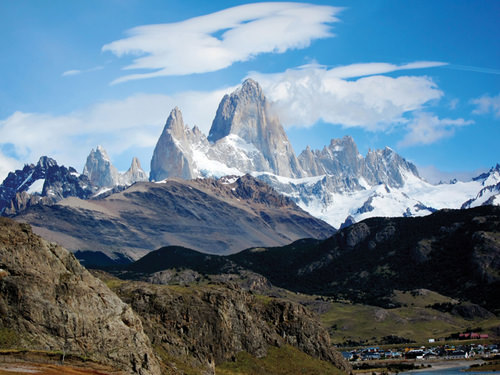
Mt. Fitz Roy is in the Andes on the border between Chile and Argentina.
::菲茨·罗伊山位于智利和阿根廷边界的安第斯山脉。
Chile is divided into three regions:
::智利分为三个区域:-
Northern Chile
, with the dry Atacama Desert
::智利北部,与干燥的阿塔卡马沙漠 -
Central Chile
, with a mild type C climate, adequate rainfall, and good farmland
::智利中部,气候温和C型气候,降雨量充足,农田肥沃 -
Southern Chile
, with lots of rainfall, rural, isolated islands, and mountains
::智利南部,降雨量大,农村、偏僻岛屿和山区
Central Chile is the core region because it has a valuable port in Valparaiso and the country’s capital city, Santiago, which is also Chile’s most populous city. Central Chile is also home to more than 90 percent of the country’s population.
::智利中部是核心地区,因为它在瓦尔帕莱索(Valparaiso)和智利首都圣地亚哥(Santiago)拥有一个宝贵的港口,圣地亚哥也是智利人口最多的城市。 智利中部也是智利90%以上人口的家园。Socioeconomic Conditions
::社会经济条件The people of Chile are 95 percent European and Mestizo. They have worked to establish a good education system and an increasing standard of living. The country had a relatively stable government until the 1970s when a short revolution brought a military dictatorship to power until 1989. The 1990s brought about a surge in economic development that has continued into the 21st century. The political situation has stabilized, and the first female president, Michelle Bachelet, was elected in 2006.
::智利人95%是欧洲人和梅斯蒂索人,他们努力建立良好的教育制度和提高生活水平。直到70年代,智利政府相对稳定,直到70年代,当时短暂的革命使军事独裁掌权,直到1989年。 1990年代导致经济发展剧增,一直持续到21世纪。 政治局势已经稳定下来,第一位女总统米歇尔·巴切莱特于2006年当选。The political system is faced with the unequal distribution of wealth that is common in Latin America. Half of the country’s wealth is concentrated in the hands of about 10 percent of the population. About 50 percent of the population is on the lower end of the socioeconomic scale. Dire poverty exists in Chile, but it is not as prevalent here as it is in the Central Andes, Paraguay, or Northeast Brazil. Chile has a thriving middle class that has made good use of the opportunities and education that Chile has offered them.
::政治制度面临着拉丁美洲普遍存在的财富分配不均的问题。 国家财富的一半集中在10%的人口手中。 大约50%的人口处于社会经济水平的低端。 智利存在赤贫,但这里的贫困不如安第斯中部、巴拉圭或巴西东北部普遍。 智利有一个繁荣的中产阶级,很好地利用了智利提供的机会和教育。Chile is abundant with natural resources that include the minerals of the Atacama Desert, extensive fishing along the coast, timber products from the south, and agricultural products from central Chile. All these factors have brought about an emerging development boom and have attracted international trading partners. The stable government and the growing economy have successfully kept inflation low, kept employment high, reduced poverty, and brought in foreign investment. In the globalized economy, Chile has managed to work with various trading partners to increase its advantages and opportunities in the international marketplace.
::智利拥有丰富的自然资源,包括阿塔卡马沙漠的矿物、沿海的大量捕捞、南部的木材产品和智利中部的农产品,所有这些因素都带来了新兴的发展繁荣并吸引了国际贸易伙伴。 稳定的政府和不断增长的经济成功地保持了低通胀,保持了高就业率,减少了贫困并吸引了外国投资。 在全球化经济中,智利设法与各种贸易伙伴合作,以增加在国际市场上的优势和机会。Chile and NAFTA
::智利和北美自由贸易协定Chile has been increasing its trading activities with its counterparts in the Pacific Rim in Europe and North America. Chile has an abundance of fish in its coastal waters and copper and minerals in the Atacama Desert and has been exporting timber products from its southern region. The United States is one of Chile’s main trading partners. Chile’s main commodity exports to the United States include paper, minerals, metals, and copper. Major agricultural products that are shipped to the United States include processed fruits, tomatoes, grapes, vegetables, and wines.
::智利一直在增加与欧洲和北美太平洋沿岸地区同行的贸易活动,智利沿海水域有丰富的鱼类,阿塔卡马沙漠有铜矿,并且一直在出口其南部地区的木材产品。 美国是智利的主要贸易伙伴之一。 智利对美国的主要商品出口包括纸张、矿物、金属和铜。 运往美国的主要农产品包括加工水果、西红柿、葡萄、蔬菜和葡萄酒。There are several good reasons why the United States trades with Chile even though it is the farthest country from the United States in South America. International trade and the seasonal patterns of agriculture have much to do with the benefits. The seasonal variations between the northern and southern hemisphere create a balance between the two. When it is winter in the north, it is summer in the south. Each has an opposing growing season for fruits and vegetables that can complement the other. Chile is an excellent counter to the opposite growing season in the Northern Hemisphere.
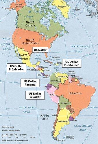
::美国与智利进行贸易有好几种原因,尽管智利是南美距离美国最远的国家。国际贸易和季节性农业模式与好处有很大关系。北半球和南半球之间的季节性变化造成了两者之间的平衡。北半球冬天是夏季,南半球是夏季。两者的水果和蔬菜的生长季节相互对立,可以互为补充。智利与北半球相反的生长季节相比是极好的。In 1994 during a summit meeting, the president of Mexico, Canada’s prime minister, and the US president agreed to allow Chile to join NAFTA. Chile’s president declared his support for his country to join NAFTA. The agreement could not be completed because of negotiation approval by the US Congress. At this time Chile entered into independent free trade agreements with both Canada and Mexico.
::1994年在一次峰会上,墨西哥总统、加拿大总理和美国总统同意允许智利加入北美自由贸易协定。 智利总统宣布支持智利加入北美自由贸易协定。 由于美国国会的谈判批准,该协议无法完成。 此时智利与加拿大和墨西哥缔结了独立的自由贸易协定。A free trade agreement was later signed between the US and Chile in 2003. Thus, Chile has free trade agreements with all three North American countries and can benefit from the mutual agreements that parallel NAFTA. In this situation, Chile is an associate trading partner and enjoys the privileges of NAFTA membership without technically being listed as a member. The United States wanted to counter Chile’s trade with Japan and Europe. Increased trade with North America diminished Chile’s trade with the European Union or the East Asian community.
::后来,美国和智利于2003年签署了自由贸易协定。 因此,智利与所有三个北美国家签订了自由贸易协定,并可以受益于与北美自由贸易协定平行的相互协议。 在这种情况下,智利是一个准贸易伙伴,享有北美自由贸易协定成员资格的特权,而没有技术上的成员资格。 美国想要对抗智利与日本和欧洲的贸易。 北美贸易的增加削弱了智利与欧盟或东亚共同体的贸易。As copper and natural resource prices fluctuate, creating unstable economic conditions, Chile has been expanding into the manufacturing sector. To retain the highest value-added profits and expand its economy, Chile will have to enlarge its manufacturing sector. Today Chile produces modest quantities of basic chemicals and electronic goods. Chile’s expansion of business and commerce has been endorsed as a model of successful economic development to be emulated by other Latin American countries.
::随着铜和自然资源价格波动,造成不稳定的经济状况,智利一直在制造业部门扩张。 为了保持最高增值利润并扩大其经济,智利将不得不扩大制造业部门。 如今,智利生产少量基本化学品和电子产品。 智利的商业和商业扩张被认可为拉丁美洲其他国家效仿的成功经济发展典范。Chile is not a full member of NAFTA but has separate free-trade agreements with all three NAFTA countries and is considered an unofficial member.
::智利不是北美自由贸易协定的正式成员,但与所有三个北美自由贸易协定国家订有单独的自由贸易协定,并被视为非正式成员。
Chile has strong ties to the economies of North America. In spite of close ties with the north, Chile has retained its unique status in the Southern Cone. Chile still has its own currency even though countries with smaller economies, such as Ecuador and El Salvador, have adopted the US dollar as their medium of exchange. As of 2010, the NAFTA members of Canada, the United States, and Mexico, along with their trading partner of Chile, all used different currencies.
::智利与北美经济体有着牢固的联系,尽管与北方关系密切,智利仍保持其在南锥体的独特地位,智利仍然拥有自己的货币,尽管厄瓜多尔和萨尔瓦多等经济规模较小的国家以美元作为交换货币,截至2010年,加拿大、美国和墨西哥的北美自由贸易协定成员国以及智利的贸易伙伴都使用不同的货币。The US dollar is the most widely used currency in the world and is also used in other Latin American countries. There has been talk of creating a similar currency within NAFTA called the Amero that would replicate the European Union’s solution, which was to create a single currency, the euro. World currencies fluctuate in value, and a stable currency would increase the capacity for creating larger trading blocs that could do business on a more even economic playing field. Chile has individual free-trade agreements with all three members of NAFTA, so any change in currency with the NAFTA countries would also affect Chile.
::美元是全世界使用最广泛的货币,其他拉丁美洲国家也使用美元。 人们一直在谈论在北美自由贸易协定中创建类似货币 — — 称为阿梅罗 — — 以复制欧盟的解决方案 — — 即创建单一货币 — — 即欧元。 世界货币价值波动,稳定的货币将提高创建大型贸易集团的能力,这些贸易集团可以在更公平的经济竞争环境中做生意。 智利与北美自由贸易协定的所有三个成员国都订有单独的自由贸易协定,因此与北美自由贸易协定国家的任何货币变化也将影响到智利。
Key Takeaways
::密钥外出-
The Southern Cone possesses large, diverse physical landscapes.
::南锥体拥有庞大而多样的自然景观。 -
Variations in terrain include tall Andean mountain peaks, desert conditions, prairie grasslands, and semitropical regions to the north.
::地形的变化包括安第斯高山峰、沙漠条件、草原和北部的半热带地区。 -
The Southern Cone is an urban realm with high percentages of the population living in large cities.
::南锥体是一个城市地区,居住在大城市的人口比例很高。 -
Primate cities dominate each country.
::以原始城市为主的每个国家。 -
Large sections of each country’s interior make up the extensive rural periphery with activities based on natural resources.
::每个国家内地大部分地区都是以自然资源为基础的活动构成的广大农村外围地区。 -
The Southern Cone is a European commercial area, and more than 85 percent of the population is of European ancestry.
::南锥体是一个欧洲商业区,85%以上的人口为欧洲血统。 -
There are few Amerindian minorities or immigrants from Africa or Asia in the Southern Cone.
::在南锥体,美洲印第安人少数民族或来自非洲或亚洲的移民寥寥无几。 -
Argentina is a large country in physical area and has a number of important regions that provide opportunities for economic prosperity. The country, however, has lacked a stable government and a consistent business climate to take advantage of Argentina’s favorable geographic situation.
::阿根廷是一个幅员辽阔的自然地区国家,拥有许多重要的地区,为经济繁荣提供了机会。 但是,阿根廷缺乏稳定的政府和稳定的商业环境来利用阿根廷有利的地理环境。 -
Chile has emerged on the global stage as a model for economic growth and stability.
::智利在全球舞台上成为经济增长和稳定的典范。 -
Chile's people have a higher standard of living, and the country has abundant natural resources.
::智利人民生活水平较高,国家拥有丰富的自然资源。 -
Chile has been a trading partner with NAFTA countries.
::智利一直是北美自由贸易协定国家的贸易伙伴。
Vocabulary Terms
::词汇术语术语Chapter 4.8 South America: The Southern Cone
::第4.8章 南美洲:南锥体d eforestation
::毁林The cutting down or destroying of large areas of forest
::砍伐或摧毁大片森林f avela
::贫民窟Slum area
::贫民区slash and burn agriculture
::砍刀和燃烧的农业a farming technique in which trees are cut down and burned to clear and fertilize the land
::一种耕作技术,砍树砍树烧火,以清除土地并施肥Applying Knowledge
::应用知识Interactive Notebook Activity
::交互式笔记活动-
List the main physical features and regions of the Southern Cone.
::列出南锥体的主要物理特征和地区。 -
Describe the location of the urban centers and explain the pattern of population distribution in the three countries of the region.
::说明城市中心的位置,并解释该区域三个国家的人口分布模式。 -
Describe the ethnic consistency of each country.
::说明每个国家的种族一致性。 -
Explain the pattern of immigration that created the region’s heritage.
::解释造成该地区遗产的移民模式。 -
Explain why Argentina has great potential for economic growth.
::解释为什么阿根廷有巨大的经济增长潜力。 -
Summarize how Chile has emerged as a strong and stable country and discuss its human and natural resources
::总结智利如何成为一个强大和稳定的国家,并讨论其人力资源和自然资源
Discussion and Study Questions
::讨论和研究问题-
What are the main physical regions of Argentina and Chile?
::阿根廷和智利的主要物理区域是什么? -
What role does agriculture play in the human activities of Uruguay?
::农业在乌拉圭人类活动中起什么作用? -
How did Uruguay manage to build up its high standard of living?
::乌拉圭如何设法提高其高生活水平? -
How does the core-periphery spatial relationship apply to Uruguay, Argentina, and Chile?
::核心-周边空间关系如何适用于乌拉圭、阿根廷和智利? -
Why is there a desert in Chile that is partially located in the tropics? Why is this desert so important?
::为什么智利有一片沙漠 部分位于热带?为什么这片沙漠如此重要? -
How does the rain shadow effect apply to both Argentina and Chile?
::雨影效应如何适用于阿根廷和智利? -
What are the main attributes and contributions of the Pampas and Patagonia?
::帕帕帕斯人和巴塔哥尼亚人的主要属性和贡献是什么? -
What are the three regions of Chile and how do they complement each other?
::智利的三个区域是什么,它们如何相互补充? -
How is Chile associated with NAFTA? Why does Chile have free-trade agreements with every NAFTA member?
::智利如何与《北美自由贸易协定》挂钩? 为什么智利与《北美自由贸易协定》的每个成员国都订有自由贸易协定? -
How does Chile complement the agricultural production of the United States and Canada?
::智利如何补充美国和加拿大的农业生产?
Real-World Geography Exercise
::现实世界地理演习Using , locate the places below. Choose 10 of the areas and find a picture and an important fact for each one. Cite your sources. Be prepared to share your answers.
::使用 , 定位下面的位置 。 选择 10 个区域, 并为每个区域寻找图片和重要事实 。 请填写您的来源 。 准备分享您的答案 。-
Atacama Desert
::阿塔卡马沙漠 -
Cape Horn
::角角角角角角 -
Chaco
::查科 -
Cuyo
::清夜 -
Falkland Islands
::福克兰群岛 -
Iguazú Falls
::伊瓜祖瀑布 -
Iguazú River
::伊瓜祖河 -
Mendoza
::门多萨 -
Mesopotamia
::美索不达米亚 -
Pampas
::帕帕帕斯 -
Paraná River
::巴拉那河 -
Patagonia
::巴塔哥尼亚 -
Tierra del Fuego
::火地岛 -
Uruguay River
::乌拉圭河 -
Valparaiso
::瓦尔帕莱索
Mapping Exercise
::绘图绘制作业ESRI GEO Inquiries
::ESSIGE 调查: Students will explore global climatic datasets to analyze the factors that constrain and enableagricultural options. The activity uses a web-based map.
::该活动使用基于网络的地图。Mapping Our World ESRI-ARGIS
::绘制我们世界的ESRI-ARGIS地图: Students will explore and compare different maps of Antarctica and investigate specific Antarctic sites to learn more about the continent. Students will also use world maps to investigate changes in ocean levels associated with the melting of the Antarctic ice sheets.
::学生们将探索和比较南极洲的不同地图,并调查南极洲的具体地点,以更多地了解该大陆,学生们还将利用世界地图调查与南极冰盖融化有关的海洋水平变化。Videos for Geography Enrichment
::地理丰富视频Helpful Websites for the Study of Geography
::地理研究有用网站is an encyclopedia funded by the Canadian government covering all branches of knowledge. Their scholarly collection includes interactive materials.
::该百科全书由加拿大政府资助,涵盖所有知识分支,其学术收藏包括交互式材料。provides information on the people, history, government, economy, energy, geography, communications, transportation, military, and transnational issues for the world's entities.
::向世界各实体提供关于人民、历史、政府、经济、能源、地理、通信、运输、军事和跨国问题的资料。is a US government website where you can find federal legislation, past and present, as well as information about the US legal system.
::是一个美国政府的网站,您可以在此找到过去和现在的联邦立法以及关于美国法律制度的信息。is a government agency website that provides current news, resources, topics of interest, information about drugs, careers in the DEA, and a tip hotline.
::是一个政府机构网站,提供最新消息、资源、感兴趣的话题、毒品信息、在缉毒局的职业以及一条小费热线。is the largest library in the world and provides manuscripts, files, information, pictures, and videos.
::图书馆是世界上最大的图书馆,提供手稿、文件、信息、图片和录像。is a US government agency website that allows users to search for and retrieve satellite images of Earth.
::这是一个美国政府机构的网站,用户可以搜索和检索地球的卫星图像。is a US government website that provides historical documents, photos, records, publications, and educator resources.
::这是一个美国政府网站,提供历史文件、照片、记录、出版物和教育资源。is a US government agency website that provides weather-related information and ocean research.
::是一个提供气象信息和海洋研究的美国政府机构网站。is a website by the United States Geological Survey and other federal, state, and local agencies that delivers topographic information for the United States.
::这是美国地质调查局和其他联邦、州和地方机构为美国提供地形信息的网站。is a massive central data source and a handy way to graphically compare nations.
::是一个庞大的中央数据源,是用图形比较国家的一种方便方式。is a website that measures most locations in the world for air pollution in real time.
::是一个实时测量世界上大多数空气污染地点的网站。is a unique statistical database which allows you to research and compare a multitude of different data on US states.
::这是一个独特的统计数据库, 使你能够研究和比较关于美国各州的多种不同数据。is an international organization founded in 1945 and made up of 193 member states. The UN maintains international peace and security, protects human rights, delivers humanitarian aid, promotes sustainable development, and upholds international law.
::联合国是一个国际组织,成立于1945年,由193个成员国组成。 联合国维护国际和平与安全,保护人权,提供人道主义援助,促进可持续发展,维护国际法。is a US government agency that provides a population clock, data, surveys, statistics, a library with information and infographics, news about the economy, and much more.
::这是一个美国政府机构,它提供人口钟、数据、调查、统计、一个拥有信息和信息资料的图书馆、关于经济的新闻,以及更多。is a US government agency website that provides scientific information about the natural hazards that threaten lives, the natural resources we rely on, the health of our ecosystems and environment, and the impacts of climate and land-use change.
::这是一个美国政府机构的网站,提供科学信息,说明威胁生命的自然危害、我们赖以生存的自然资源、生态系统和环境的健康以及气候和土地使用变化的影响。is a US government website that provides the latest presidential news, information about the budget, policy, defense, and many more topics.
::提供最新总统新闻、预算、政策、国防等资讯, 以及更多议题。is under the United Nations and provides leadership on matters critical to health, shapes the research agenda on health, and monitors the health situation and assessing health trends around the world. Their website provides information on the state of health around the world, outbreaks, current health news, and more.
::网站提供世界各地卫生状况、疫情爆发、最新卫生新闻等信息。is an intergovernmental organization that regulates international trade. The website provides information on the history of the multilateral trading system, featured videos, news and events, trade topics, and more.
::该网站提供关于多边贸易体系历史的信息、视频、新闻和事件、贸易专题等等。 -
List the main physical features and regions of the Southern Cone.