5.1:欧洲:物理地点和气候(2天)
章节大纲
-
Chapter Challenges
::章次 挑战-
Describe the various climate types and physical landforms of the European continent.
::描述欧洲大陆的各种气候类型和物理地形形态。 -
Explain how Europe’s physical geography has supported its development.
::解释欧洲的地理地理状况如何支持其发展。 -
List Europe’s various natural resources.
::列出欧洲的各种自然资源。 -
Summarize briefly the environmental concerns Europe faces.
::简要概述欧洲面临的环境问题。
Student Learning Objectives
::学生学习目标TEKS Regional World Geography Unit 05 Europe Chapter 5.1 Physical Location and Climate
::TERS 区域世界地理股 05 Europe 第5.1章 地理位置和气候WG.3B Describe the physical processes that affect the environments of regions, including weather, tectonic forces, erosion, and soil-building processes.
::WG.3B 描述影响区域环境的物理过程,包括天气、构造力、侵蚀和土壤建设过程。WG.4B Describe different landforms and the physical processes that cause their development.
::WG.4B 描述不同的土地形态和导致其发展的物理过程。WG.4C Explain the influence of climate on the distribution of biomes in different regions.
::WG.4C 解释气候对不同区域生物群落分布的影响。WG.13A Interpret maps to explain the division of land, including man-made and natural borders, into separate political units such as cities, states or countries.
::WG.13A 解释地图,解释土地划分,包括人造边界和自然边界,分为不同的政治单位,如城市、州或国家。WG.16A Describe distinctive cultural patterns and landscapes associated with different places in Texas, the United States, and other regions of the world and how these patterns influenced the processes of innovation and diffusion.
::WG.16A 描述与得克萨斯州、美国和世界其他地区不同地方有关的独特文化模式和景观,以及这些模式如何影响创新和传播进程。WG.21C Create and interpret different types of maps to answer geographic questions, infer relationships, and analyze change.
::WG.21C 创建和解释不同类型的地图,以回答地理问题、推断关系和分析变化。WG.22A Design and draw appropriate graphics such as maps, diagrams, tables, and graphs to communicate geographic features, distributions, and relationships, features, distributions, and relationships.
::WG.22A 设计和绘制适当的图形,如地图、图表、表格和图表,以交流地理特征、分布和关系、特征、分布和关系。WG.22C Use geographic terminology correctly.
::WG.22C 正确使用地理术语。WG.22D Use standard grammar, spelling, sentence structure, and punctuation.
::WG.22D 使用标准语法、拼写、句子结构和标点。Europe: Physical Location and Climate
::欧洲:实际地点和气候
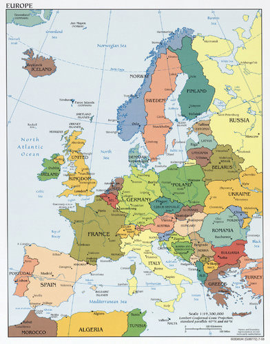
Map of Europe
::欧洲地图Location and Climate
::地点和气候Europe is a northern continent. All of the British Isles, for example, fall above the 50th parallel. If we compare Europe’s position on a globe with that of the contiguous United States, we see that much of Europe lies north of the United States. Paris, France is at about the same latitude as Fargo, North Dakota. Athens, Greece is at about the same latitude as St. Louis, Missouri. Europe’s northern position affects its growing seasons. Europe is also surrounded by bodies of water: the Atlantic Ocean borders Europe on the west, the Arctic Ocean borders Europe to the north, and many seas surround the various peninsulas and coastal regions.
::欧洲是一个北方大陆。 比如,所有不列颠群岛都位于第50个平行线之上。 如果我们将欧洲在地球上的位置与毗连的美国相比,我们就会发现欧洲大部分位于美国北部。 巴黎,法国与北达科他州法尔戈(Fargo,北达科他州 ) 的纬度大致相同。雅典,希腊与密苏里州圣路易斯(Sta Louis)的纬度大致相同。 欧洲的北位影响着它的生长季节。 欧洲的北位也受到水体的包围:大西洋与欧洲接壤,北与欧洲接壤的北冰洋,以及环绕着各个半岛和沿海地区的许多海洋。The oceans have a significant influence on the world’s climates. They collect and store vast amounts of solar energy, particularly around the equator, and transport that heat with their currents. Ocean currents can move water for thousands of miles from one temperature zone to another. Because oceans can absorb so much heat, maritime climates are often milder than continental ones. With smaller temperature variations from day to night as well as from winter to summer.
::海洋对世界气候有着重大影响。 海洋收集并储存了大量太阳能,特别是赤道周围的太阳能,并用洋流输送热量。 洋流可以将水从一个温度区移到另一个温度区数千英里。 由于海洋能吸收如此多的热量,海洋气候往往比大陆气候温和。 日间和夜间以及冬季和夏季的温度变化都比较小。This influences not only temperature but also precipitation patterns over wide regions of Europe and the rest of the world. Water moderates coastal environments in a number of ways. Water heats and cools more slowly than land. This heat inertia allows coastal communities to have climates that tend to be more moderate for places so far north. Interior Europe does not benefit from coastal bodies of water and can have winters as cold as those found within the upper Midwestern United States.
::这不仅影响欧洲和世界其他地区的温度,而且影响降水模式; 水以多种方式调节沿海环境; 水热和冷却比土地慢; 这种热惯性使沿海社区能够有气候,对迄今为止的北方地区来说,气候往往比较温和; 内地欧洲没有沿海水域,而且冬季可以象美国上中西部地区一样寒冷。
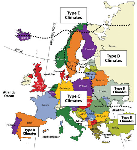
This map illustrates the dominant climate types in Europe.
::该地图说明了欧洲主要的气候类型。
The Gulf Stream is perhaps the most important current for Western Europe’s climate. It is responsible for producing a temperate climate for a northern latitude location. Most of Western Europe has a moderate type C climate. The Gulf Stream originates in the Gulf of Mexico, where the waters are warmed. This powerful current follows the Eastern Seaboard of the United States before crossing the Atlantic Ocean for Europe. The Gulf Stream’s most dramatic effect can be found in the western coastal islands of Scotland. It has a mild enough climate to support some forms of tropical flora, even though it is at a degree of latitude as far north as Hudson Bay, Canada.
::海湾流或许是西欧气候的最重要潮流。 海湾流对西欧气候来说也许是最重要的潮流。 它负责为北纬地区创造温和气候。 西欧大部分地区有中度的C型气候。 海湾流起源于墨西哥湾,那里有温暖的水域。 这一强大的潮流沿美国东海岸而过大西洋到欧洲。 海湾流最戏剧性的影响可见于苏格兰西海岸岛屿。 它拥有足够温和的气候支持某些形式的热带植物,尽管离加拿大哈德逊湾以北有一定的纬度。The coast of Norway provides another example. While most of Norway’s coastal area lies within the Arctic region, it remains free of ice and snow throughout the winter. People living farther inland and closer to Eastern Europe and Russia encounter the colder type D climates. Colder air sweeps down from the Arctic north or from eastern Siberia and provides colder winters in this eastern region. The Mediterranean Sea moderates the temperature to the south, providing a type C climate around its shores. Type C climates merge with type E climates at or near the Arctic Circle in Norway and in Iceland.
::挪威的海岸提供了另一个例子。 虽然挪威的大部分沿海地区位于北极地区,但整个冬天仍然没有冰雪和冰雪。 居住在内陆更远的地方以及靠近东欧和俄罗斯的人遇到更寒冷的D型气候。 寒冷的空气从北极北部或从西伯利亚东部向下吹,为这个东部地区提供了更寒冷的冬天。 地中海将温度向南调温,提供了其海岸周围的C型气候。 C型气候与挪威和冰岛北极圈内或附近的E型气候相融合。Four Main European Landforms
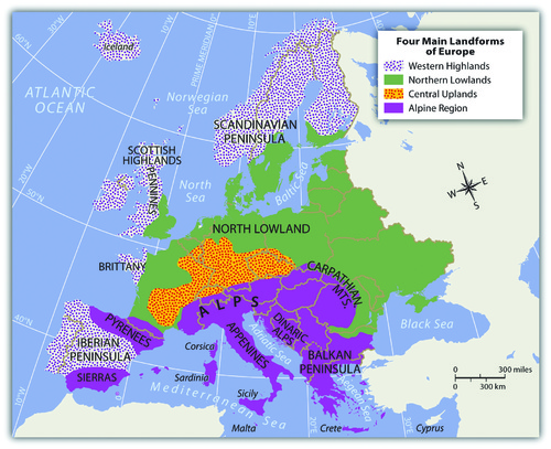
::四个主要欧洲地貌Europe has four main landforms, many islands and peninsulas, and various climate types. The four main landforms include the Alpine region, Central Uplands, Northern Lowlands, and Western Highlands. Each represents a different physical part of Europe. The wide-ranging physical environment has provided Europe with an abundance of biodiversity. Biodiversity refers to the diversity of the number of species in an ecosystem and the number of members in each species.
::欧洲有四大陆地形态、许多岛屿和半岛以及各种气候类型,四大陆地形态包括阿尔卑斯山脉区域、中央高地、北部低地和西部高地,它们各自代表着欧洲不同的自然部分,广泛的自然环境为欧洲提供了丰富的生物多样性,生物多样性是指生态系统物种数量的多样性和每个物种成员的数量。The physical environment also provides natural resources and raw materials for human activities. Europe’s moderate climates and favorable relative location are supported by its access to many rivers and seas. These advantageous developmental factors supported the development of the Industrial Revolution in Europe, which gave rise to highly technical and urban societies.
::自然环境也为人类活动提供了自然资源和原材料。 欧洲温和的气候和有利的相对位置得到了许多河流和海洋的通道的支持。 这些有利的发展因素支持了欧洲工业革命的发展,这一革命导致了高度技术性和城市社会。Europe has emerged as one of the core economic centers of the global economy. Associated with the urbanization of Europe are high human population densities that have placed a strain on the natural environment. As a result, there has been significant deforestation and the loss of natural habitat, which has decreased the realm’s level of biodiversity.
::欧洲已成为全球经济的核心经济中心之一。 与欧洲城市化相关的是高人口密度给自然环境带来压力。 结果,大量森林砍伐和自然栖息地丧失,降低了生物多样性水平。Rivers are abundant in Europe and have provided adequate transportation for travel and trade throughout its history. Most of Europe is accessible by water transport either via the many rivers or along the extensive coastlines of the peninsulas and islands. The Danube and the Rhine are two main rivers that divide Europe. Both have their origins in the region of southern Germany on or near the border with Switzerland. The Rhine River flows north and empties into the North Sea in Rotterdam, Holland, one of the world’s busiest ports. The Danube flows east through various major European cities, such as Vienna, Budapest, and Belgrade before emptying into the Black Sea.
::欧洲的河流丰富,在历史上为旅行和贸易提供了充足的交通。 大部分欧洲都通过许多河流或半岛和岛屿的漫长海岸线进行水运。多瑙河和莱茵河是分裂欧洲的两个主要河流。这两个河流都起源于与瑞士接壤的德国南部地区或靠近瑞士的边界。莱茵河向北流动,并进入世界最繁忙港口之一鹿特丹的北海,荷兰。多瑙河通过欧洲各大城市向东流动,如维也纳、布达佩斯和贝尔格莱德,然后进入黑海。
This map illustrates the four main landforms of Europe: Western Highlands, Northern Lowlands, Central Uplands, and the Alpine Region.
::该地图说明了欧洲的四大土地形态:西部高地、北部低地、中部高地和阿尔卑斯地区。Alpine Region
::阿尔卑斯高山地区The High Alps, which range from eastern France to Slovenia, are central to the Alpine region. Included in the Alpine Range are the Pyrenees, located on the border between France and Spain; the Apennines, running the length of Italy; the Carpathians, looping around Romania from Slovakia; and finally, the shorter Dinaric Alps in former Yugoslavia. Mountains usually provide minerals and ores that were placed there when the earth’s internal processes created the mountains. Mountains also isolate people by acting as a dividing range that can separate people into cultural groups.
::高阿尔卑斯山脉从法国东部到斯洛文尼亚,是阿尔卑斯山脉的中心地区。 高山山脉包括位于法国和西班牙边界上的比利牛斯山脉、横跨意大利的阿彭尼山脉、从斯洛伐克环绕罗马尼亚的喀尔巴阡山脉、以及前南斯拉夫较短的迪纳里克阿尔卑斯山脉。 山区通常提供矿物质和矿石,这些矿物质和矿石是地球内部过程形成山地时存放在那里的。 山区也通过将人分为文化群体来孤立人们。
The Alpine Region: Eiger, Mönch, and Jungfrau from Männlichen—Swiss Alps.
::阿尔卑斯山地区:梅恩利琴-苏威斯阿尔卑斯山的艾格尔、明希和丛林。
The Alpine region encircles the Mediterranean coastlines, which have more temperate type C climates with hot, dry summers and cool, wet winters. This climate type allows for the cultivation of food products such as olives, citrus fruit, figs, apricots, and grapes. Evergreen scrub oaks and other drought-resistant shrubs are common in the Mediterranean region.
::阿尔卑斯山地区环绕着地中海海岸线,这些海岸线的C型温带气候比较温和,夏季炎热、干燥、冬季寒冷、潮湿,可种植橄榄、柑橘水果、无花果、杏仁和葡萄等粮食产品,地中海区域常有长绿清洗橡树和其他抗旱灌木。The Central Uplands
::中央高地The region bordering the main Alps to the north, which includes a large portion of southern Germany extending eastward, is known as the Central Uplands. These foothills to the Alps are excellent sources of raw materials such as forest products and coal, which are valuable resources for industrial activities. The Central Uplands are also good locations for dairy farming and cattle raising. This middle portion of the continent has a mixed deciduous-coniferous forest, and the vegetation includes oak, elm, and maple trees intermingled with pine and fir trees. There are four distinct seasons in this region with moderate amounts of precipitation year round.
::北部与主要阿尔卑斯山接壤的地区,包括德国南部向东延伸的很大一部分地区,称为中高地,阿尔卑斯山的山丘是林产品和煤等原材料的极佳来源,这些原料是工业活动的宝贵资源;中部高地也是奶制品种植和养牛的好地点;非洲大陆的这一中部地区森林变低多,森林杂杂杂,植被包括橡树、和与松树和松树混合的绿树;该地区有四个不同的季节,每年降水量不多。
Central Uplands in North Rhine-Westphalia, Germany.
::德国北莱茵-威斯特伐利亚中央高地Northern Lowlands
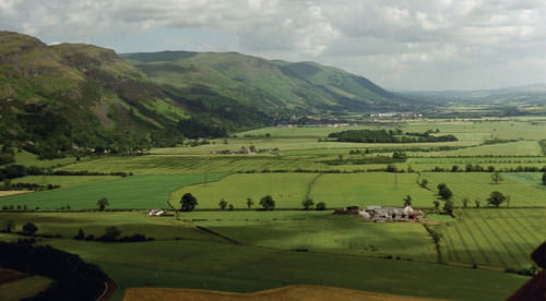
::北部低地The Western Highlands meet the lowlands in central Scotland.
::西高地与苏格兰中部的低地交汇。
Similar to the breadbasket of the Midwestern United States, Europe’s Northern Lowlands possess excellent farmland. Major agricultural operations here provide for a large European population. The land is flat to rolling with relatively good soils. The Northern Lowlands is a great plain that extends across northern Europe from southern France, north through Germany, and then all the way to the Ural Mountains of Russia.
::欧洲北部低地拥有极好的农田。 主要农业经营为欧洲人口提供了大量资源。 土地平坦,土壤平坦。 北低地是一个广阔的平原,横跨北欧,从法国南部向北延伸到德国,然后一直延伸到俄罗斯乌拉尔山脉。This area is typified by prairies and areas of tall grasses and is mostly used as farmland. The lowlands area also contains bogs, heaths, and lakes. The eastern part of this great plain around Ukraine is characterized by a steppe climate. It is a flat and relatively dry region with short grasses and is generally an agricultural region. This eastern area has great swings in temperature, both from day to night and from summer to winter. Winter temperatures in the eastern steppe can drop to below −40 °F, with summer temperatures reaching as high as 105 °F. This is similar to the steppes of eastern Montana or western North Dakota in the United States.
::该地区以草原和高草面积为特征,主要用作农田,低地地区也含有沼泽、热量和湖泊,乌克兰周围这个大平原的东部以草原气候为特征,是一个平坦、相对干燥的地区,有短草,一般是一个农业地区,东部地区从白天到夜间,从夏季到冬季,温度波动很大,东部大草原的冬季温度可降至40°F以下,夏季气温可高达105°F,这与美国蒙大拿东部或北达科他西部的草原类似。Western Highlands
::西高地On the western edges of the European continent are short rugged mountains called highlands that extend throughout Norway, parts of Britain, and portions of the Iberian Peninsula of Portugal and Spain. These Western Highlands have sparse populations and are less attractive to large farming operations. Agriculture is usually limited to grazing livestock or farming in the valleys and meadows.
::欧洲大陆西部边缘是矮小的崎岖山区,称为高原,遍及挪威、英国部分地区以及葡萄牙和西班牙的伊比里亚半岛部分地区。 这些西部高地人口稀少,对大型农耕活动吸引力较小。 农业通常仅限于放牧牲畜或在山谷和草原耕作。The Scottish Highlands are noted for their wool products and Highland cattle. In England, the central chain of highlands proved valuable during the Industrial Revolution because they enabled hydropower and later, coal mining. Coal mining was prominent in the highland regions of Wales. In the far northern regions of Scandinavia, tundra environments prevail. In this coldest and driest highland climate, permafrost dominates the landscape, and the land becomes soggy for brief periods during the few weeks of summer. The flora consists primarily of lichens, mosses, low shrubs, and wildflowers.
::苏格兰高原因其羊毛产品和高原牛而备受注意,英格兰高原中部地带在工业革命期间被证明是有价值的,因为它们能提供水电,后来又进行煤矿开采。煤矿开采在威尔士高原地区十分突出。在斯堪的纳维亚最北部地区,苔原环境十分普遍。在这种最寒冷和最干燥的高地气候中,永久冻土占据了地貌,土地在短短几个星期的夏季里就变得泥沼泽。植物主要包括、苔丝、低灌木和野花。
Isle of Skye in the Scottish Highlands.
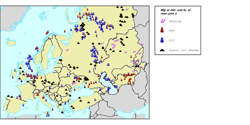
::苏格兰高地的斯凯岛Natural Resources in Europe
::欧洲自然资源This graphic illustrates the natural resources than can be found in Europe.
::这一图示显示了欧洲所无法找到的自然资源。
The ready access to vast areas of the Atlantic Ocean and a number of major seas, lakes, and rivers has made fish an important natural resource in Europe. The seas around Europe provide about ten percent of the world’s fish catches. Mirroring the situation around the world, European fishing activity increased as the population increased. Europeans are becoming increasingly aware of the effects of overfishing. Stocks of Atlantic cod and Atlantic mackerel are considered to be at risk because of the threats of overfishing and changes in the environment that are affecting natural mortality and slowing spawning.
::大西洋大片海域以及许多大海、湖泊和河流的畅通无阻,使鱼类成为欧洲的重要自然资源。 欧洲周围的海洋提供了全世界鱼类捕获量的大约10%。 与世界各地的情况类似,欧洲的捕鱼活动随着人口的增长而增加。 欧洲人越来越意识到过度捕捞的影响。 大西洋鳕鱼和大西洋鱼种群被认为面临风险,因为过度捕捞的威胁和环境变化正在影响自然死亡和产卵减速。Stocks of eastern North Atlantic Bluefin tuna are also attracting attention for the same reason. Other species of fish in the North Atlantic and the Baltic Sea are considered over fished. Changes to the fishery are a major concern for ecological reasons and also because fish comprise such a significant portion of the European economy. Different regions of Europe have abundant fresh water supplies, good soils, and various minerals.
::东北大西洋蓝鳍金枪鱼种群也出于同样原因引起注意,北大西洋和波罗的海的其他鱼种被视为过度捕捞,渔业变化是主要关切的一个生态原因,也因为鱼类在欧洲经济中占如此大的比例,欧洲不同地区有丰富的淡水供应、良好的土壤和各种矿物。The mineral deposits in Europe is iron ore, which can be found in Sweden, France, and Ukraine. Other minerals exist in smaller quantities, including copper, lead, bauxite, manganese, nickel, gold, silver, potash, clay, gypsum, dolomite, and salt. Extraction activities have supported the continent’s industrialization.
::欧洲的矿藏是铁矿石,可以在瑞典、法国和乌克兰找到。 其他矿藏数量较少,包括铜、铅、铝土、锰、镍、金、银、花粉、粘土、石膏、白石膏和盐。 开采活动支持了非洲大陆的工业化。The countries of Europe, with the formation of the European Union (EU), began to work toward shared research and policies with respect to the fishery. The Common Fisheries Policy was drafted and includes strict and extensive rules and guidelines for fishing, particularly of cod. Because the rules are so strict and controversial, Norway and Iceland have opted out of the EU rather than agree to abide by these rules. The effect of these rules is incompletely known, but the cod stocks in the North Sea do not seem to be rebounding as expected.
::随着欧洲联盟(欧盟)的成立,欧洲国家开始致力于渔业方面的共同研究和政策。 《共同渔业政策》的起草包括了严格的、广泛的渔业规则和准则,特别是鳕鱼。 由于规则如此严格和有争议,挪威和冰岛选择退出欧盟,而不是同意遵守这些规则。 这些规则的效果尚不完全为人所知,但北海的鳕鱼种群似乎并没有像预期的那样反弹。Forest covers more than 40 percent of the continent’s land area, with the majority on the Russian side. Forests exist primarily in the less populous Nordic and Baltic countries and in Central Europe. About one-half of the forest land in Europe is privately owned. Interestingly, there are several different forms of private ownership, including large family holdings, holdings by forest industries, and small to very small holdings by thousands of individuals.
::森林占非洲大陆土地面积的40%以上,大部分在俄罗斯一方。 森林主要存在于人口较少的北欧和波罗的海国家以及中欧。 欧洲大约一半的林地是私有的。 有趣的是,有几种不同的私人所有权形式,包括家庭财产、森林工业财产以及数千人小到很小的股份。Most of the forested land is managed, and about 85 percent of the forests produce exploitable resources. The percentage of forested land in Europe is rebounding because of an extensive tree-planting initiative since 2000. However, pollution has caused great harm to the forests of Poland, the Czech Republic, and eastern Germany, and acid rain and air pollution have harmed forests in southern Germany.
::大部分林地都得到了管理,大约85%的林地生产了可开发的资源。 欧洲林地的百分比由于2000年以来的植树活动而正在反弹。 但是,污染对波兰、捷克共和国和德国东部的森林造成了极大伤害,酸雨和空气污染对德国南部的森林造成了伤害。Soil resources are of critical importance. Soil is necessary for growing food, supporting livestock, supporting other natural resources such as the forests, and supplying groundwater. Soil resources are only just beginning to receive attention in Europe. Problems to be addressed include loss of topsoil from development and building activities, outdated agricultural practices, mining, contamination from industries and other sources, and acidification as a result of acid rain.
::土壤是增加粮食、支持牲畜、支持森林等其他自然资源和提供地下水所必需的; 土壤资源在欧洲才刚刚开始引起注意; 需要解决的问题包括发展和建筑活动造成的表土流失、过时的农业做法、采矿、工业和其他来源的污染以及酸雨造成的酸化。Coal, now substantially depleted, is abundant in several areas of Great Britain, including some offshore areas, as well as in the industrial centers of Germany and in Ukraine. Other coal deposits are found in Belgium, France, Spain, the Czech Republic, Poland, Slovakia, and Russia. The burning of coal has produced high levels of air pollution. Acid rain has been a major concern in the northern countries, where wind currents carry pollutants north into Scandinavia from the industrial regions of Central Europe.
::在英国的一些地区,包括一些近海地区,以及在德国和乌克兰的工业中心,煤炭现已大量枯竭,其他煤矿在比利时、法国、西班牙、捷克共和国、波兰、斯洛伐克和俄罗斯都有,煤炭的燃烧造成了大量的空气污染。 酸雨一直是北方国家的一个主要问题,风流将污染物从中欧工业地区向北运入斯堪的纳维亚。In Scandinavia, acid rain has diminished fish populations in many of the lakes. Forest health is also being challenged, which is diminishing the economic conditions of regions that depend on forests for their economic survival.
::在斯堪的纳维亚,酸雨减少了许多湖泊的鱼类数量,森林健康也受到挑战,因为森林健康正在降低依赖森林生存的地区的经济条件。Petroleum and natural gas deposits exist underneath the North Sea and were first tapped in the 1970s. Five European countries have rights to these resources, including Norway, the United Kingdom, Denmark, the Netherlands, and Germany, with Norway holding the bulk of the rights. The governments of these five nations agree that, although tapped only decades ago, half the North Sea oil reserves have been consumed.
::石油和天然气储量存在于北海之下,在1970年代首次开采。 五个欧洲国家,包括挪威、英国、丹麦、荷兰和德国,对这些资源拥有权利,挪威拥有大部分权利。 这五个国家的政府同意,尽管在几十年前开采了一半北海石油储备,但已经消耗了。Before the extraction of petroleum products from the North Sea, Russia and the former Soviet Union’s other republics supplied petroleum to Europe. These areas still have a number of active extraction operations. Hydroelectric power has been important in Europe as well. With both coal and oil resources largely depleted and the desire to avoid the environmental damage caused by dams, the European Energy Commission is devoting substantial energy and resources to encouraging the use of renewable resources such as wind and solar energy.
::在从北海、俄罗斯和前苏联其他共和国提取石油产品之前,俄罗斯和前苏联其他共和国向欧洲提供石油。 这些地区仍然有一些积极的开采作业。 欧洲的水电发电也非常重要。 煤炭和石油资源基本枯竭,人们也希望避免水坝造成的环境破坏,欧洲能源委员会正投入大量能源和资源鼓励利用风能和太阳能等可再生资源。In March 2007, European leaders agreed that a binding target of 20 percent of all energy must be from alternative sources by 2020. Also, 10 percent of the transportation fuels used by EU members must be sustainable biofuels.
::2007年3月,欧洲领导人同意,到2020年,所有能源的20%必须来自替代能源的有约束力的目标。 此外,欧盟成员国所使用的10%的运输燃料必须是可持续的生物燃料。
Key Takeaways
::密钥外出-
The Gulf Stream provides a moderate type C climate for much of Western Europe.
::海湾流为西欧大部分地区提供了中度C型气候。 -
Eastern Europe can experience colder type D climates.
::东欧可以经历更寒冷的D型气候。 -
Europe has four main physical landforms that provide a diversity of natural resources.
::欧洲有四种主要的地貌形态,提供多种多样的自然资源。 -
The North European Lowland holds the majority of its agricultural potential.
::北欧低地拥有大部分农业潜力。 -
An increase in population has also increased the demand on the environment. Various environmental concerns are becoming more evident.
::人口增长也增加了对环境的需求,各种环境问题越来越明显。 -
Acid rain from industrialization has caused extensive damage to forests and fish populations in northern Europe. Atlantic fisheries are also experiencing a decline in production.
::工业化产生的酸雨对北欧的森林和鱼类种群造成了广泛损害,大西洋渔业的产量也在下降。
Vocabulary Terms
::词汇术语术语Chapter 5.1 Europe: Physical Location and Climate
::第5.1章 欧洲:物理地点和气候Arctic c limates
::北极气候Short, cool summer, very cold snowy winter--East Norway, North Sweden and all of Finland
::挪威、瑞典北部和芬兰全国Highland c limates
::高地气候The Climate bas ed on elevation--The Alpine Regions
::以高高高山地区为基础的气候h umid c ontinental
::湿润大陆Hot, wet summer, Cold snowy winter cool , wet summer, cold very snowy winter -Poland eastward and north into south Sweden and Finland
::炎热、潮湿、潮湿、潮湿、寒冷、雪寒冬冷、潮湿、潮湿、寒冷、非常雪冷的冬季 -- -- 波兰东部和北部进入南瑞典和芬兰m arine w est c oast c limate
::海洋西海岸气候Warm summer, cool and wet winter--Germany, UK, and some of Iceland and Norway
::温暖的夏季、寒冷和湿湿的冬季 -- -- 德国、联合王国以及冰岛和挪威的一些国家M editerranean Climate
::地中海气候Hot and dry summer, mild and rainy winter--Parts of Italy, Spain, and Greece
::意大利、西班牙和希腊的温和和雨季 -- -- 意大利、西班牙和希腊s teppe c limate
::草草气候Semi- desert with occasional rain--Parts of Spain
::半沙漠,偶尔有降雨 西班牙的半沙漠部分s ubtropical c limate
::亚热带气候Hot and Wet Summer, mild and damp winter--Northern Italy and parts of Bosnia Herzegovina, Croatia and Slovenia
::冬季 -- -- 意大利北部以及波斯尼亚和黑塞哥维那、克罗地亚和斯洛文尼亚部分地区Applying Knowledge
::应用知识Interactive Notebook Activities
::互动笔记活动-
Describe
the various climate types and physical landforms of the European continent.
::描述欧洲大陆的各种气候类型和物理地形形态。 -
Explain
how Europe’s physical geography has supported its development.
::解释欧洲的地理地理状况如何支持其发展。 -
List
Europe’s various natural resources.
::列出欧洲的各种自然资源。 -
Summarize
briefly the environmental concerns Europe faces.
::简要概述欧洲面临的环境问题。
Discussion and Study Questions
::讨论和研究问题-
Identify and locate the four main physical landforms of Europe. What are the main features of each?
::查明和确定欧洲的四种主要自然地形。 -
How do these landforms and natural resources provide wealth, opportunities, and advantages to the European community?
::这些土地形态和自然资源如何为欧洲共同体提供财富、机会和优势? -
Why is there a higher concentration of acid rain in northern Europe? How is acid rain affecting the environment?
::为什么北欧酸雨的浓度更高?酸雨对环境的影响如何? -
What two rivers act to naturally divide Europe? Which rivers flow through Paris and London?
::是什么两条河流自然分裂了欧洲?哪条河流通过巴黎和伦敦? -
Track the flow of each of the two main rivers and identify the major cities that each flows through.
::跟踪两条主要河流的每条流量,并确定每一条河流经过的主要城市。 -
Where are the major mountain ranges of the Alpine region?
::阿尔卑斯山地区的主要山脉在哪里? -
How does the Alpine region contribute to the economies of the countries of Europe?
::阿尔卑斯山地区如何为欧洲国家的经济作出贡献? -
Why do the countries of Western Europe have more moderate type C climates even though they are in the northern latitudes?
::为什么西欧国家即使位于北纬地区, C型气候却较为温和? -
How does agricultural production vary with physical landforms or climate changes?
::农业生产与实际土地形态或气候变化有何不同? -
How are Europeans addressing the decline in the North Atlantic fishing industry?
::欧洲人如何应对北大西洋捕鱼业的衰退?
Real-World Geography Exercises
::现实世界地理演习-
Using
, complete the following activities:
-
Locate each place on the bulleted list below.
::在下面的子弹名单上 找到每个地方 -
Find the nearest city with an international airport in proximity to each location on the bulleted list below.
::找到最近的城市,在下面子弹清单上每个地点附近有一个国际机场。 -
Calculate the distance and travel time by plane to each city from the
in San Diego, California.
::计算从加利福尼亚圣地亚哥飞往每个城市的飞机距离和旅行时间。
::使用,完成以下活动: 确定以下子弹清单上的每个地点; 找到最近的城市, 在下面子弹清单上的每个地点附近有一个国际机场。 计算从加利福尼亚圣地亚哥飞往每个城市的飞机距离和飞行时间。 -
Locate each place on the bulleted list below.
-
Using
, determine the latitude and longitude for each location on the bulleted list below.
::使用,确定以下子弹列表中每个位置的纬度和经度。 -
Be prepared to share and discuss your answers.
::准备分享和讨论你的答案
-
Alpine region
::阿尔卑斯地区 -
Alps
::阿尔卑斯山 -
Apennines
::亚麻 -
Black Forest
::黑森林 -
Black Sea
::黑海黑海黑海 -
Carpathians
::喀尔巴阡山脉 -
Central Uplands
::中央中央高地 -
Danube River
::多瑙河河 -
Dinaric Alps
::Dinaric 阿尔卑斯山 -
Iberian Peninsula
::伊比利亚半岛 -
Mediterranean Sea
::地中海 地中海 -
North Sea
::北海 -
Northern Lowlands
::北部低地 -
Pyrenees
::比利人 -
Rhine River
::莱茵河 -
Scottish Highlands
::苏格兰高地 -
Strait of Gibraltar
::直布罗陀海峡 -
Ural Mountains
::乌拉尔山 -
Western Highlands
::西高地
Mapping Exercise
::绘图绘制作业Mapping Our World Module 5 Lesson 1
::绘制我们的世界单元5第一课程: In this activity, students will use GIS to investigate different types of international boundaries, explore the implications of various boundary configurations, and observe boundary changes that occurred in recent years.
:::在这一活动中,学生将利用地理信息系统调查不同类型的国际边界,探讨各种边界配置的影响,并观察近年来发生的边界变化。Videos for Geography Enrichment
::地理丰富视频Helpful Websites for the Study of Geography
::地理研究有用网站is an encyclopedia funded by the Canadian government covering all branches of knowledge. Their scholarly collection includes interactive materials.
::该百科全书由加拿大政府资助,涵盖所有知识分支,其学术收藏包括交互式材料。provides information on the people, history, government, economy, energy, geography, communications, transportation, military, and transnational issues for the world's entities.
::向世界各实体提供关于人民、历史、政府、经济、能源、地理、通信、运输、军事和跨国问题的资料。is a US government website where you can find federal legislation, past and present, as well as information about the US legal system.
::是一个美国政府的网站,您可以在此找到过去和现在的联邦立法以及关于美国法律制度的信息。is a government agency website that provides current news, resources, topics of interest, information about drugs, careers in the DEA, and a tip hotline.
::是一个政府机构网站,提供最新消息、资源、感兴趣的话题、毒品信息、在缉毒局的职业以及一条小费热线。is the largest library in the world and provides manuscripts, files, information, pictures, and videos.
::图书馆是世界上最大的图书馆,提供手稿、文件、信息、图片和录像。is a US government agency website that allows users to search for and retrieve satellite images of Earth.
::这是一个美国政府机构的网站,用户可以搜索和检索地球的卫星图像。is a US government website that provides historical documents, photos, records, publications, and educator resources.
::这是一个美国政府网站,提供历史文件、照片、记录、出版物和教育资源。is a US government agency website that provides weather-related information and ocean research.
::是一个提供气象信息和海洋研究的美国政府机构网站。is a website by the United States Geological Survey and other federal, state, and local agencies that delivers topographic information for the United States.
::这是美国地质调查局和其他联邦、州和地方机构为美国提供地形信息的网站。is a massive central data source and a handy way to graphically compare nations.
::是一个庞大的中央数据源,是用图形比较国家的一种方便方式。is a website that measures most locations in the world for air pollution in real time.
::是一个实时测量世界上大多数空气污染地点的网站。is a unique statistical database, which allows you to research and compare a multitude of different data on US states.
::这是一个独特的统计数据库, 使你能够研究和比较关于美国各州的多种不同数据。is an international organization founded in 1945 and made up of 193 member states. The UN maintains international peace and security, protects human rights, delivers humanitarian aid, promotes sustainable development, and upholds international law.
::联合国是一个国际组织,成立于1945年,由193个成员国组成。 联合国维护国际和平与安全,保护人权,提供人道主义援助,促进可持续发展,维护国际法。is a US government agency that provides a population clock, data, surveys, statistics, a library with information and infographics, news about the economy, and much more.
::这是一个美国政府机构,它提供人口钟、数据、调查、统计、一个拥有信息和信息资料的图书馆、关于经济的新闻,以及更多。is a US government agency website that provides scientific information about the natural hazards that threaten lives, the natural resources we rely on, the health of our ecosystems and environment, and the impacts of climate and land-use change.
::这是一个美国政府机构的网站,提供科学信息,说明威胁生命的自然危害、我们赖以生存的自然资源、生态系统和环境的健康以及气候和土地使用变化的影响。is a US government website that provides the latest presidential news, information about the budget, policy, defense, and many more topics.
::提供最新总统新闻、预算、政策、国防等资讯, 以及更多议题。is under the United Nations and provides leadership on matters critical to health, shapes the research agenda on health, and monitors the health situation and assessing health trends around the world. Their website provides information on the state of health around the world, outbreaks, current health news, and more.
::网站提供世界各地卫生状况、疫情爆发、最新卫生新闻等信息。is an intergovernmental organization that regulates international trade. The website provides information on the history of the multilateral trading system, featured videos, news and events, trade topics, and more.
::该网站提供关于多边贸易体系历史的信息、视频、新闻和事件、贸易专题等等。 -
Describe the various climate types and physical landforms of the European continent.