2.2地球科学野外工作
章节大纲
-
Do Earth scientists work in the field?
::地球科学家是否从事实地工作?Yes! Many geologists do field work to better understand Earth. Many others go on field trips to learn about certain types of geology . In National Park, a geologist could learn about mountain building. They could learn about how glaciers modify landscapes. They could take photos to assist them in teaching a class. They could just have a great time in a geologically fascinating area!
::是的! 许多地质学家都为更好地了解地球做实地工作。 还有许多人去实地考察, 学习某些类型的地质学。 在国家公园, 地质学家可以学习山岳建筑。 他们可以学习冰川如何改变地貌。 他们可以拍照协助他们教授一个课程。 他们可以在地质学上非常迷人的地区度过一段美好的时光 !Field Work
::外地工作Many Earth scientists collect data in the field, called field work . The data may be from observations or measurements. The scientists may create a geological of the area. They might write detailed descriptions of the and their relationships. They may collect samples to analyze in the lab. They may do a combination of all of these! Earth science laboratories contain high-tech equipment. That equipment can reveal the chemistry or age of a rock sample. Geologists do field work to look for resources. They may study a region for environmental cleanup. There are many other reasons for going in the field. One common reason is just to understand the region better.
::许多地球科学家收集实地数据,称为实地工作。 数据可能来自观测或测量。 科学家们可以对该地区进行地质学研究, 他们可以详细描述这些地质学及其关系。 他们可以在实验室中收集样本进行分析。 他们可以将所有这些样本结合起来进行分析。 地球科学实验室包含高科技设备。 这些设备可以揭示岩石样本的化学或年代。 地质学家可以进行实地工作以寻找资源。 他们可以研究环境清理的区域。 进行实地研究有许多其他原因。 一个共同的原因就是更好地了解该地区。Field Trips
::实地考察To really understand geology and some of the other , it's best to go out in the field! Geology students in many colleges and universities go on a lot of field trips . Some of the concepts presented in this text can be illustrated by features seen in the field. Where possible, photos are provided to illustrate concepts. So we can get some of the benefit of going on a field trip! Some of the places that are featured in this text are described below.
::要真正理解地质学和其他一些地质学, 最好到实地去! 许多学院和大学的地质学学生都会进行大量的实地考察。 本文本中的一些概念可以用实地的特征来说明。 在可能的情况下, 照片可以用来说明概念。 这样我们就可以从实地考察中得到一些好处 。 下面介绍本文中的一些地方 。California
::加利福尼亚州California has a lot of different environments and a complex geologic history. California is a great place to study geology! In the satellite image above ( Figure ), it is possible to identify the major geographic (physical) features of California.
::在以上卫星图像(图)中,可以确定加利福尼亚的主要地理(物理)特征。- The Coast Range runs the length of the state along the Pacific coast. A tremendous amount of rain falls in the northern part of the range, so the region is heavily forested. There is less rainfall and vegetation further south.
::海岸线长于太平洋沿岸,北部降雨量很大,因此该地区森林茂密,降雨量较少,植被更南。
- The Central Valley is made up of the Sacramento and San Joaquin river valleys. The Central Valley runs through about half of the central part of the state. The valley is located between the mountains of the Coast Range and the Sierra Nevada. The Central Valley is one of the most important agricultural regions in the world.
::中部谷地由萨克拉门托河和圣华金河流域组成,中部谷地占国家中部的大约一半,位于沿海地区山区和内华达山脉之间,中部谷地是世界上最重要的农业地区之一。
- The Sierra Nevada Mountain range lies east of the Central Valley. In the winter, the mountains are covered by snow . In this image, there is little to no snow, and the bare rocks of the high peaks are showing. Yosemite National Park lies within the Sierra Nevada.
::内华达山脉位于中谷谷以东。冬天,山丘被雪覆盖。在这个图象中,几乎没有雪或无雪,高山的裸露岩石正在显现。约塞米特国家公园位于内华达山脉内。
- East of the Sierra Nevada and into the state of Nevada, the climate is very arid. Death Valley, the driest spot in the United States, is found there.
::内华达州东部和内华达州,气候非常干旱。 死亡谷是美国最干燥的地方。
- Mt. Shasta, at the north end of the Sierra Nevada, is the southernmost remaining volcanic cone in the Cascades Range.
::内华达山脉北端的沙斯塔山 是卡斯卡德斯山脉最南端的火山锥体
Nevada
::内华达州East of the image of California is Nevada. Very different from California, Nevada is extremely arid. The Basin and Range province consists of a set of mountains and valleys. You can see the ranges as dark brown rocky regions and the valleys as lighter brown.
::加利福尼亚州的东面是内华达州。内华达州与加利福尼亚州非常不同, 内华达州极为干旱。 盆地和山脉省由一系列山脉和山谷组成。 你可以把山脉看成深棕色岩石地区, 山谷则看成浅棕色。Pacific Northwest
::西北太平洋North of California along the Pacific Coast is Oregon, Washington, and then British Columbia in Canada. This region is similar to California in having a coastal range, a central valley (at least in part of Oregon), and very arid lands east of the high Cascades mountains. The Cascades are a chain of that run through Oregon and Washington, and into British Columbia ( Figure ). Some of them are easily spotted on this image as white spots in the midst of the green forests of the Cascades Range.
::连锁山脉是穿过俄勒冈州和华盛顿以及不列颠哥伦比亚省(图 ) 的连锁山脉。 其中一些连锁山脉很容易在这张图像上被人们看到,在连锁山脉的绿色森林中,有些是白色的斑点。Idaho, Montana, Wyoming
::爱达荷、蒙大拿、怀俄明This image shows the states of Idaho, Montana, and Wyoming. The northern part of Idaho and northwestern Montana is mountainous and forested. Arid lands lie to the east. The states of Idaho, Montana, and Wyoming are located east of the Pacific Northwest. The landscape ranges from mountainous forests to deserts ( Figure ).
::爱达荷州、蒙大拿州和怀俄明州位于西北太平洋以东,地貌从山林到沙漠(图)。Glacier National Park
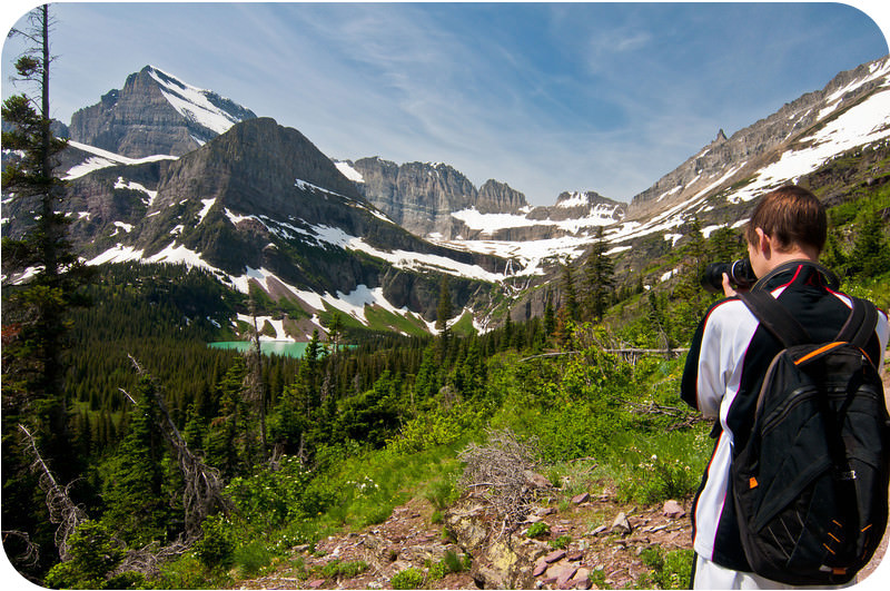
::冰川国家公园This satellite image of Glacier National Park in the summer shows snow-capped peaks and glacial valleys, many of which are now lakes. Glacier National Park in the northwestern part of Montana ( Figure ) reaches to the Canadian border. Glacier National Park ( Figure ) was established in 1910 to preserve the wild lands and wildlife. But less and higher summer temperatures has decimated most of the glaciers. Glacier National Park is a fantastic place to see glacial features, beautiful scenery, and wildlife ( Figure ).
::蒙大拿西北面的冰川国家公园(Figure ) , 到达加拿大边境。 1910年建立了冰川国家公园(Figure ) , 以保护野生土地和野生生物。 但夏季气温越低和越高,大多数冰川被摧毁。 冰川国家公园是看到冰川特征、美丽的风景和野生生物(Figure ) 的绝佳地方。Naturalists enjoy the hike to Iceberg Lake in Glacier National Park. Yellowstone National Park
::黄石公园国家公园Grand Prismatic Spring is one of the spectacular features of Yellowstone National Park. Yellowstone National Park ( Figure ) is in the northwestern corner of Wyoming and consists of about 2.2 million acres of land. Yellowstone is best known for its incredible geysers , which occur because the park is located directly above a large magma chamber that is very close to the surface. The park also has gorgeous mountain scenery and fantastic wildlife, including herds of bison ( Figure ). The best known feature is Old Faithful. This geyser is not the highest, largest, or most beautiful, but it is the most reliable.
::黄石公园位于怀俄明西北角,有大约220万英亩的土地,黄石公园以其令人难以置信的喷泉闻名,因为黄石公园直接位于靠近地表的大型岩浆室上,该公园还拥有华丽的山景和美妙的野生生物,包括野牛群(Figure)。最有名的特征是古老的信仰。这个喷泉不是最高、最大或最美的,但它是最可靠的。Bison are just some of the amazing creatures that roam around Yellowstone. Southwest
::西南西南The Southwest is home to mountains, canyons, valleys, and flat lands. Many features discussed in the concepts presented in this text can be seen in the Southwest. The Southwestern United States ( Figure ) is a great place to study geology. The region is so arid that in most locations rocks and structures are easily seen. In several concepts we will visit parts of the Southwest to view geology in the field.
::美国西南地区是研究地质学的好地方,该地区非常干旱,在大多数地方很容易看到岩石和结构。 在几个概念中,我们将访问西南地区,观察实地地质学。Grand Canyon
::大峡谷From the rim, the Grand Canyon gives a sense of the vastness of geologic time and the immensity of the planet. Geologists say that the Grand Canyon ( Figure ) has "layer cake geology." This is because the rock strata are in layers. They are extremely easy to see. are like a book that tells the story of the environment in which they formed. Rock units can be traced across large expanses. Looking down into the Grand Canyon, you get a sense of the vastness of space and of time.
::地质学家说大峡谷有“ 层蛋糕地质学 ” 。 这是因为岩层是层层的。 它们非常容易看到。 它们就像一本讲述它们形成的环境故事的书。 岩石单位可以从大峡谷中追踪到大峡谷。 向大峡谷看, 你可以看到空间和时间的广度。Hawaiian Islands
::夏威夷群岛The Hawaiian Islands from space. The Hawaiian Islands ( Figure ) are in the central Pacific Ocean. The islands are volcanoes that increase in age from southeast to northwest. The youngest island is the Big Island of Hawaii at the southeast end of the chain. The volcanoes get older through Maui, Kahoolawe, Lanai, Molokai, Oahu, Kauai, and Niihau Islands through the northwest. The Kilauea volcano on Hawaii has been erupting almost continuously since 1983. There are also eruptions at an underwater volcano called Loihi seamount . Loihi is the youngest volcano. Hawaii is a fantastic place to see volcanic eruptions and features.
::夏威夷群岛(Figure)位于太平洋中部,这些岛屿是从东南到西北不断老化的火山,最年轻的岛屿是链的东南端的夏威夷大岛,火山在毛伊岛、卡胡拉威岛、拉奈岛、莫洛凯岛、奥胡岛、考艾岛和尼豪岛的西北部老化,夏威夷的基拉乌亚火山自1983年以来几乎连续不断爆发,在称为Loihi海山的水下火山也爆发,洛伊希火山是最小的火山,夏威夷是火山爆发和特征的绝佳地方。Summary
::摘要- Earth scientists learn about many aspects of their disciplines by going out into the field.
::地球科学家们通过外出到田野学习其学科的许多方面。
- Field trips are an important part of the education of a geology student.
::实地考察是地质学学生教育的重要组成部分。
- The western United States is a great place to see examples of many types of geological phenomena.
::美国西部是许多类型地质现象的例子的极好地方。
Review
::回顾- Describe the geography of California. What features can you see in this state?
::描述一下加州的地理 州里你能看到什么特征?
- Where are the arid lands in the western United States? Why are arid lands important for understanding geology?
::美国西部的干旱土地在哪里?为什么干旱土地对了解地质学很重要?
Explore More
::探索更多Use the resources below to answer the questions that follow.
::利用以下资源回答以下问题。- How large is Yellowstone?
::黄石公园有多大?
- What is Yellowstone?
::什么是黄石公园?
- How often has Yellowstone erupted in the past? What does this mean?
::黄石公园过去多久爆发一次?这是什么意思?
- What heats the geysers and supervolcano of Yellowstone?
::黄石公园的喷泉和超火山热是什么?
- How many islands make up Hawaii?
::夏威夷有多少岛屿组成?
- How long has Kīlauea been continuously erupting?
::肯lauea持续爆发多久了?
- Explain how Hawaii formed.
::解释一下夏威夷是如何形成的
- What is the Big Island of Hawaii?
::什么是夏威夷大岛?
- The Coast Range runs the length of the state along the Pacific coast. A tremendous amount of rain falls in the northern part of the range, so the region is heavily forested. There is less rainfall and vegetation further south.