2.4位置
章节大纲
-
How could you locate this feature?
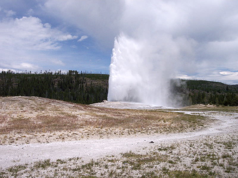
::你怎么能找到这个特征?Geologists, hikers, and many other people need to be able to say where they are or where they want to go. They need to be able to mark a location on a . The opening photo is of Old Faithful Geyser in Yellowstone National Park. It is located at 44°30'N and 110°150'W. Let’s explore what that means.
::地质学家、远足学家和许多其他人需要能够说出他们在哪里或者他们想去的地方。他们需要能够标出一个地点。首张照片是黄石公园国家公园的老忠实盖瑟。该照片位于北纬44°30'和西经110°150'。让我们探讨这意味着什么。Location
::地点地点地点地点地点To describe your location, you could use a coordinate system . To do this you could use two reference points. For example, you could use streets. Maybe you are at the corner of Maple Avenue and Main Street. Or, you could use one point of reference, a distance, and an angle for direction. If you want to meet up with a friend, you could tell them “I am two blocks due north of your apartment.” Can you identify the point of reference, the distance, and the angle?
::要描述您的位置, 您可以使用一个坐标系统。 要做到这一点, 您可以使用两个参考点 。 比如, 您可以使用街道 。 或者您可以在Maple大道和Main Street 的拐角处。 或者您可以使用一个参考点、 一个距离和一个方向角度。 如果您想要和朋友见面, 您可以告诉他们“ 我离你公寓北边两个街区 ” 。 您能确定参考点、 距离和角度吗 ?Map Coordinates
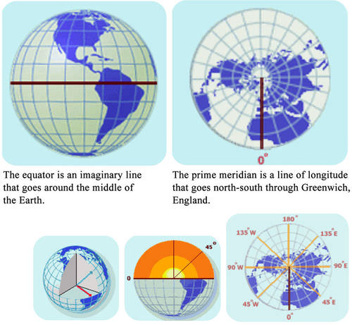
::地图坐标Most maps use a grid of lines to help you to find your location. This grid system is called a geographic coordinate system . Using this system you can define your location by two numbers, and longitude . Both numbers are angles between your location, the center of Earth, and a reference line ( Figure ).
::大多数地图都使用行网格来帮助您查找位置。 这个网格系统被称为地理坐标系统。 您可以使用这个系统来定义您的位置, 有两个数字和经度。 两个数字都是您的位置、 地球中心 和 参考线( 图 ) 之间的角度 。Lines of latitude start with the equator. Lines of longitude begin at the prime meridian. Latitude
::纬纬度Lines of latitude circle around Earth. The equator is a line of latitude right in the middle of the planet . Latitude is divided into degrees: 90° north of the equator and 90° south of the equator. One degree is subdivided into 60 minutes. One minute is subdivided into 60 seconds. The equator is at 0°. The equator is an equal distance from both the North and South Poles. If you know your latitude, you know how far you are north or south of the equator.
::环绕地球的纬度线。赤道是地球中部的右纬线。纬度分为度:赤道以北90度,赤道以南90度。一个度又细分为60分钟。1分钟再细分为60秒。赤道为0度。赤道与北极和南极的距离相等。如果知道纬度,你就会知道赤道以北或以南有多远。Longitude
::经经经度Lines of longitude are circles that go around Earth from pole to pole, like the sections of an orange. Longitude is also measured in degrees, which are subdivided into minutes and seconds. Lines of longitude start at the Prime Meridian , which is 0°. The Prime Meridian is a circle that runs north to south and passes through Greenwich, England. Longitude tells you how far you are east or west from the Prime Meridian ( Figure ). On the opposite side of the planet from the Prime Meridian is the International Date Line. It is at 180°. This is the place where a new day first arrives.
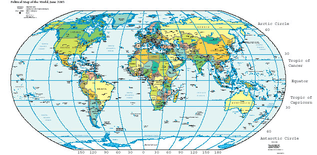
::经度线是环绕地球的圆圈,从极到极到极,就像橙色区段。经度也以度度测量,再分为分秒。经度线从零度的梅里迪安总理开始。梅里迪安总理是一个北向南、穿过英格兰格林威治的圆圈。经度告诉你你距离梅里迪安总理(Figure)的东向或西向有多远。从梅里迪安总理(Prime Meridian)到地球的对面是国际日期线。它是在180度的。这是新一天首次到达的地方。Lines of latitude and longitude form convenient reference points on a map, including the Equator, the Tropic of Cancer at 23.5°N, Tropic of Capricorn at 23.5°S, Arctic Circle at 66.5°N, and Antarctic Circle at 66.5°S. You can remember latitude and longitude by doing jumping jacks. When your hands are above your head and your feet are together, say longitude (your body is long!). When you put your arms out to the side horizontally, say latitude (your head and arms make a cross, like the “t” in latitude). While you are jumping, your arms are going the same way as each of these grid lines: horizontal for latitude and vertical for longitude.
::你可以通过跳插孔记住纬度和经度。当你的双手在头顶上,双脚在一起的时候,请说经度(身体是长的 ) 。当你把手臂向侧水平伸出来时,请说纬度(你的头和手臂在纬度上树立一个十字架 ) 。当你跳跃的时候,你的手臂和这些网格线一样行:纬度是横向的,经度是垂直的。Using Latitude and Longitude on a Map
::在地图上使用纬度和经度If you know the latitude and longitude of a place, you can find it on a map. Simply place one finger on the latitude on the vertical axis of the map. Place your other finger on the longitude along the horizontal axis of the map. Move your fingers along the latitude and longitude lines until they meet. For example, say the location you want to find is at 30°N and 90°W. Place your right finger along 30°N at the right of the map. Place your left finger along the bottom at 90°W. Move your fingers along the lines until they meet. Your location should be near New Orleans, Louisiana, along the Gulf coast of the United States. Now can you locate Old Faithful, 44°30'N and 110°150'W, on a map?
::如果您知道一个地方的纬度和经度, 您可以在地图上找到它。 只需在地图垂直轴的纬度上指一个手指, 在地图水平轴上指一个手指, 在地图水平轴上指另一个手指。 沿着纬度和经度线移动, 直到他们相遇。 比如, 说您想要找到的位置是北纬30°和西经90°。 请将您的右手指放在地图右纬30°。 将您的左手指放在下方90°W 处; 将您的手指沿着路线移动直到他们相遇。 您的位置应该在美国湾沿岸的纽奥良附近。 现在您可以在地图上找到旧的信仰, 北纬44°30'N 和 110°150'W ?What if you want to know the latitude and longitude of your location? If you know where you are on a map, point to the place with your fingers. Take one finger and move it along the latitude line to find your latitude. Then move another finger along the longitude line to find your longitude.
::如果你想知道你所在位置的纬度和经度呢?如果你知道地图上的位置,请用手指指向那个地方。拿一根手指,然后沿着纬度线移动,以寻找你的纬度。然后沿着经度线移动另一根手指,以寻找你的经度。Global Positioning System
::全球定位系统In order to get latitude, longitude, and you need several instruments. What if you could do the same thing with only one instrument? A Global Positioning System (GPS) receiver is all that is needed to locate your position on the Earth’s surface in many places.
::为了获得纬度、经度和您需要多种仪器。 如果您能只用一种仪器做同样的事情呢? 全球定位系统接收器是确定您在地球表面许多地方的位置所需要的。By 1993, the United States military had launched 24 satellites to help soldiers locate their positions on battlefields. This system of satellites was called the Global Positioning System (GPS). Later, the United States government allowed the public to use this system. Here’s how it works.
::到1993年,美国军方已经发射了24颗卫星帮助士兵在战场上定位。 这一卫星系统被称为全球定位系统(GPS ) 。 后来,美国政府允许公众使用该系统。 其运作方式如下:(a) You need a GPS receiver to use the GPS system. (b) It takes signals from four GPS satellites to find your location precisely on the surface. You must have a GPS receiver to use the system. You can buy many types of these in stores. The GPS receiver detects radio signals from nearby GPS satellites. There are precise clocks on each satellite and in the receiver. The receiver measures the time for radio signals from satellites to reach it. The receiver uses the time and the speed of radio signals to calculate the distance between the receiver and the satellite. The receiver does this with at least four different satellites to locate its position on the Earth’s surface ( Figure ). GPS receivers are now being built into many items, such as cell phones and cars.
::您必须有一个 GPS 接收器才能使用这个系统。 您可以在仓库里购买许多类型的 GPS 。 GPS 接收器检测附近GPS 卫星的无线电信号。 每个卫星和接收器都有精确的时钟。 接收器测量卫星的无线电信号到达它的时间。 接收器使用无线电信号的时间和速度来计算接收器和卫星之间的距离。 接收器使用至少四个不同的卫星来定位其在地球表面的位置( 图 ) 。 GPS 接收器现在正在安装在很多物品中, 如手机和汽车 。You can use a GPS receiver to tell you how to get to Old Faithful.
::你可以用GPS接收器 告诉你如何到达旧的信仰Summary
::摘要- Latitude is the distance north or south of the equator. It is expressed as a number between 0° and 90° north or south.
::纬度是赤道以北或以南的距离,以北或以南0°至90°的数值表示。
- Longitude is the distance east or west of the Prime Meridian. It is expressed as a number between 0° and 180° east or west.
::经度是梅里迪安总理东面或西面的距离,表示为东面或西面0°至180°之间的数字。
- The global positioning system uses satellites to display very accurate location information on a special receiver.
::全球定位系统利用卫星在特别接收器上显示非常准确的定位信息。
Review
::回顾- What would a latitude number in the Southern Hemisphere look like?
::南半球的纬度数字会是什么样子?
- Define latitude and longitude.
::定义纬度和经度。
- Why are GPS devices so accurate?
::为什么全球定位系统设备如此精确?
Explore More
::探索更多Use the resource below to answer the questions that follow.
::利用以下资源回答以下问题。- What is latitude and what does a measurement of latitude give?
::纬度的测量结果是什么?
- What is longitude and what does a measurement of longitude give?
::经度和经度的测量结果是什么?
- By looking at the latitude image, tell where the vertex of the latitude lines is?
::通过查看纬度图像, 说明纬度线的顶部在哪里?
- Where is the 90-degree North latitude line?
::北纬90度线在哪里?
- How many longitude lines go through the South Pole?
::南极有几条经度线?
- Is the United States in the Eastern or Western Hemisphere? What about India?
::美国在东半球还是西半球?
- Latitude is the distance north or south of the equator. It is expressed as a number between 0° and 90° north or south.