2.5方向
章节大纲
-
How do you indicate which way the wind blows?
::你如何指出风吹哪条路?When an object is moving, it is not enough to describe its . We also need to know direction. For example, a wind blows a storm over your school. Where is that storm coming from? Where is it going? Direction is also needed to indicate where two points are relative to each other on a .
::当一个物体移动时,描述它是不够的。 我们还需要知道方向。 例如, 风吹到你的学校上。 暴风从哪来? 暴风从哪来? 要往哪里去? 还需要方向来说明两个点之间在一点上相对的位置 。Direction
::方向To connect two points accurately you need a direction. This occurs when you need to go from point A to point B. It also happens if you want to describe where something is going. If you are walking across a field, for example, you might say you're going north 20° east.
::要准确连接两个点, 您需要一个方向。 当您需要从 A 点到 B 点时, 就会发生这种情况。 如果您想要描述某件事情的去向, 也会发生这种情况。 例如, 如果您正在跨过一个字段, 比如说, 您可能会说您正在向东北走 20 度 。Compass
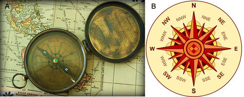
::指南集The most common way to find direction is by using a compass . A compass is a device with a floating needle ( Figure ). The needle is a small magnet that aligns itself with the Earth’s magnetic field . The compass needle always points to magnetic north. If you have a compass and you find north, you can then know any other direction. See the directions, such as east, south, west, etc., on a compass rose .
::找到方向的最常用方法是使用指南针。 指南针是带有浮动针的装置( 图表 ) 。 针是小磁铁,它与地球磁场相连接。 指南针总是指向磁北。 如果您有一个指南针, 并且找到北边, 你就可以知道任何其他方向 。 在指南针玫瑰上看到方向, 如东、 南、 西等。(a) A compass is a device that is used to determine direction. The needle points to Earth’s magnetic north pole. (b) A compass rose shows the four major directions, plus intermediates between them.
:a) 指南针是一种用来确定方向的装置,针指向地球磁性北极。 (b) 指南针玫瑰显示四个主要方向,加上它们之间的中间点。
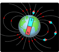
A compass needle lines up with Earth’s magnetic north pole. This is different from Earth’s geographic north pole, also called true north. The geographic north pole is the top of an imaginary line. This line is the axis around which Earth rotates. The geographic north pole is much like the spindle of a spinning top. The location of the geographic north pole does not change. However, the magnetic north pole shifts in location over time. Depending on where you live, you can correct for the difference between the two poles when you use a map and a compass ( Figure ).
::与地球磁性北极线相连的罗盘针。 这与地球地理上的北极线不同, 也称为真实的北极线。 地理上的北极线是虚构的线的顶部。 这是地球旋转的轴线。 地理上的北极线与旋转的顶部的脊柱很相似。 地理上的北极线的位置没有改变。 然而, 磁性北极线随时间变化而变化。 取决于您住在哪里, 当您使用地图和指南针( Figure ) 时, 您可以纠正两极之间的差别 。Earth’s magnetic north pole is about 11 degrees offset from its geographic north pole.
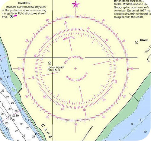
::地球磁极北纬约11度与其地理上的北极相抵消。Some maps have a double compass rose. This allows users to make the corrections between magnetic north and true north. An example is a nautical chart that boaters use to chart their positions at sea ( Figure ).
::有些地图有双罗盘玫瑰。 这样用户就可以在磁性北向和真实北向之间进行校正。 例如, 航海者用海图绘制海上位置图( 图 ) 。Nautical maps include a double compass rose that shows both magnetic directions (inner circle) and geographic compass directions (outer circle).
::航空地图包括一个双罗盘,显示磁向(内圈)和地理罗盘方向(外圈)。Polar Coordinate System
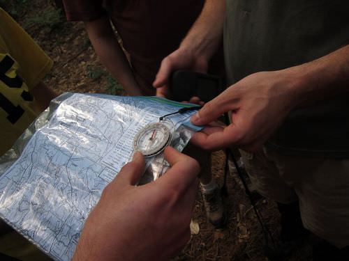
::极地坐标系统You can also use a polar coordinate system . Your location is marked by an angle and distance from some reference point. The angle is usually the angle between your location, the reference point, and a line pointing north. The distance is given in meters or kilometers. To find your location or to move from place to place, you need a map, a compass, and some way to measure your distance, such as a range finder.
::您也可以使用极地坐标系统。您的位置由某个引用点的一个角度和距离标记。 角度通常是您的位置、 参考点和向北的一条线之间的角。 距离以米或公里表示。 要找到您的位置或从一个地方移动到另一个地方, 您需要一个地图、 指南针, 以及测量您距离的某种方法, 如范围查找器 。Suppose you need to go from your location to a marker that is 20°E and 500 m from your current position. You must do the following:
::假设您需要从您的位置到一个从您当前位置20°E和500米的标记。 您必须做到如下:- Use the compass and compass rose on the map to orient your map with north.
::使用地图上的指南针和指南针 将您的地图与北对齐。
- Use the compass to find which direction is 20°E.
::使用指南针查找哪个方向是 20°E。
- Walk 500 meters in that direction to reach your destination.
::往那方向走500米 到达目的地
Polar coordinates are used in a sport called orienteering. People who do orienteering use a compass and a map with polar coordinates. Participants find their way along a course across wilderness terrain ( Figure ). They move to various checkpoints along the course. The winner is the person who completes the course in the fastest time.
::极地坐标用于名为 " 定向运动 " 的运动中。 参加定向运动的人使用指南针和带极地坐标的地图。 参加者在穿越荒野地带的路线中找到方向(图)。 他们沿着路线移动到各个检查站。 获胜者是最快时间完成课程的人。A topographic map like one that you might use for the sport of orienteering.
::一张地形图 就像一张你可能用来 参加东方运动的地形图Summary
::摘要- Direction is expressed as north, south, east, or west, or some gradation between them.
::方向以北、南、东或西表示,或以它们之间的某种分级表示。
- A compass can be used to indicate direction. A compass rose shows direction on a map or chart.
::指南针可用于指示方向。指南针向上显示地图或图表上的方向。
- To find your location or to move from place to place, you need a map, a compass, and some way to measure your distance.
::要找到您的位置或从一个地方到另一个地方, 您需要一个地图、指南针, 以及测量距离的方法 。
Review
::回顾- How does a compass work?
::指南针怎么用?
- What is a polar coordinate system?
::什么是极地协调系统?
- How does someone do orienteering?
::一个人如何指导方向?
- Use the compass and compass rose on the map to orient your map with north.