2.6高程
Section outline
-
Where are you in the third dimension?
::第三个维度你在哪里?Mt. Sheridan in Yellowstone National Park is higher above sea level than most locations. It is at 10,250 ft (3,124 m). When you're up at that elevation, you definitely think about the third dimension. It is, of course, elevation, or height above sea level. You can see Mt. Sheridan in the opening image and on the .
::黄石公园的Sheridan山高于海平面,海平面比大部分地方高。是10,250英尺(3,124米)。当你到达高地时,你肯定会想到第三个维度。当然,这是海平面的高度或高度。你可以在开阔图象和海平面上看到Sheridan山。Elevation
::电梯As you know, the surface of Earth is not flat. Some places are high, and some places are low. For example, mountain ranges like the Sierra Nevada in California or the Andes in South America are high above the surrounding areas. An accurate must take into account the third dimension. Elevation is the height above or below sea level. Sea level refers to the height of the ocean’s surface. This is the midpoint between high and low tide . Sea level can vary from place to place, but scientists base their elevation measurements on the average, or mean, sea level to make sure they have a standard reference point.
::如你所知,地球表面不是平坦的。有些地方是高的,有些地方是低的。例如,加利福尼亚的山内华达山脉或南美洲的安第斯山脉等山脉高在周边地区之上。准确的考虑第三个维度是高在海平面上或海平面下。海平面是指海平面的高度。这是高潮和低潮之间的中点。海平面可以随地点而变化,但科学家们的海平面测量以海平面的平均值或平均值为基础,以确保它们有一个标准参照点。Topography
::地形We can describe the topography of a region by measuring the height or depth of that feature relative to sea level ( Figure ). You might measure your height relative to your classmates. When your class lines up, some kids make high “mountains,” while others are more like small hills!
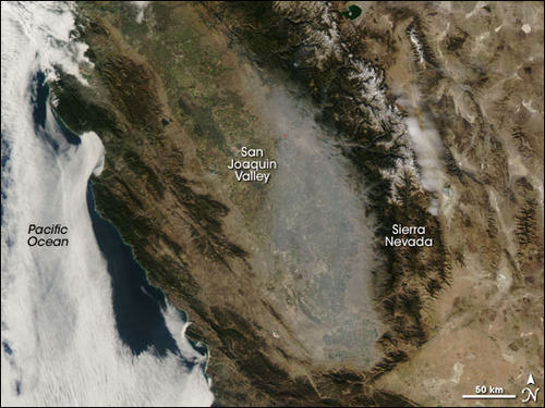
::我们可以根据海平面测量一个区域的高度或深度来描述一个区域的地形(图 ) 。 您可以测量与同学相比的身高 。 当班级排队时, 一些孩子会做高“ 山地 ” , 另一些孩子则更像小山地 !This is a satellite image of California. The highs, like the Sierra Nevada mountains, are rocky looking. During the winter, the peaks are capped with snow. The lows, like the San Joaquin Valley, are lighter and smoother. Green indicates forest.
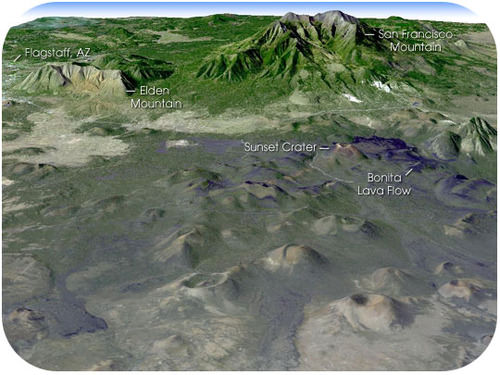
::这是加利福尼亚的卫星图象。高山和内华达山脉一样,都是岩石。冬天,山峰被雪封住。低谷,如圣华金谷,更轻、更平滑。绿色显示森林。Relief , or terrain, includes all the landforms of a region. For example, the image below shows the San Francisco Peaks in northern Arizona ( Figure ). Features on the map include mountains, hills , and lava flows. You can recognize these features from the differences in elevation.
::例如,下图显示亚利桑那北部的旧金山峰(图示 ) 。 地图上的地貌包括山、 山和熔岩流。 您可以从海拔的差异中认出这些特征 。This image was made from data of the Landsat satellite. It shows the topography of the San Francisco Peaks and surrounding areas.
::这一图像来自Landsat卫星的数据,显示旧金山峰及其周围地区的地形。Summary
::摘要- Elevation refers to height above average sea level.
::高度高于平均海平面。
- The topography of a region describes its highs and lows.
::一个区域的地形描述其高低。
- Sea level is the midpoint between high and low tide. It can vary around Earth.
::海平面是高潮和低潮之间的中点,在地球周围可能会有变化。
Review
::回顾- What is elevation, and what is its reference point?
::什么是海拔,它的参照点是什么?
- How is topography different from relief?
::地形与救济有何不同?
- Why is the average, or mean, sea level used as a reference point?
::为什么平均或平均海平面被用作参照点?
Explore More
::探索更多Use the resource below to answer the questions that follow.
::利用以下资源回答以下问题。- Why is elevation important?
::为什么海拔很重要?
- What is digital elevation data used for?
::数字海拔数据用于什么?
- What is the NED?
::什么是NED? (NED: NED: NED: NED: NED: NED)是什么?
- What is the primary source of the NED's new elevation data?
::NED新海拔数据的主要来源是什么?
- What else is LIDAR used for?
::LIDAR还用来做什么?
- Why is the continued funding of this project important?
::为什么继续资助这一项目很重要?
- Elevation refers to height above average sea level.