2.7地图
章节大纲
-
What information does a map show?
::地图显示什么信息 ?Maps can convey a lot of different types of information. They can tell you where you are, or they can tell you something about a . Maps can display the relief of an area. They can indicate something about the society that lives in the area. Different types of maps show many different types of things.
::地图可以传达许多不同类型的信息。 他们可以告诉你你在哪里, 或者可以告诉你一些关于某个区域的信息。 地图可以显示一个区域的宽度。 他们可以显示一些关于生活在该地区的社会的信息。 不同类型的地图可以显示许多不同的类型。Maps as Models
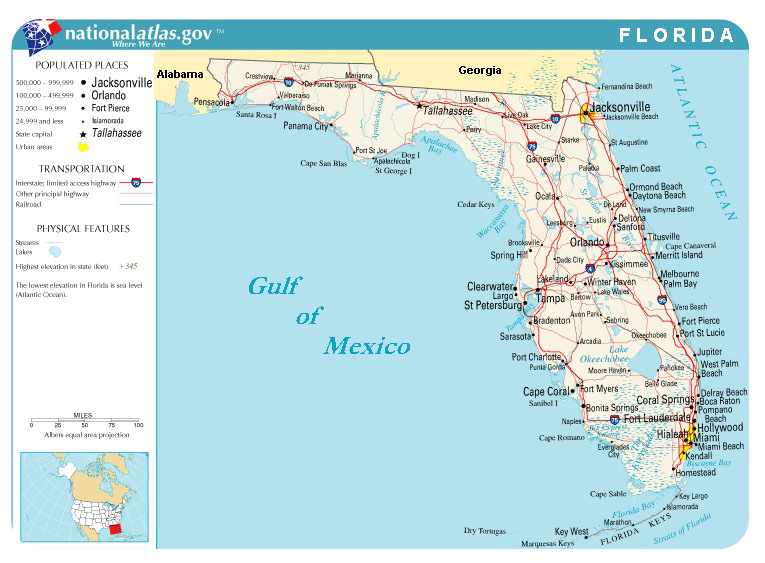
::地图作为模型Imagine you are going on a road trip. Perhaps you are going on vacation. How do you know where to go? Most likely, you will use a map. A map is a picture of specific parts of Earth’s surface. There are many types of maps. Each map gives us different information. Let’s look at a road map, which is the probably the most common map that you use ( Figure ).
::想象一下你会去旅行。也许你会去度假。你怎么知道要去哪里?你最有可能使用地图。地图是地球表面特定部分的图。地图有多种类型。每张地图给我们提供不同的信息。让我们看看路线图,这可能是你最常用的地图(图 ) 。A road map of the state of Florida. What information can you get from this map?
::佛罗里达州的路线图 你能从这张地图上得到什么信息?Map Legends
::地图图图图图图You can see the following on this road map of Florida ( Figure ):
::在佛罗里达的行进图(图)上,您可以看到以下内容:- The boundaries of the state show its shape.
::国家的边界显示它的形状。
- Black dots represent the cities. Each city is named. The size of the dot represents the population of the city.
::黑点代表城市,每个城市都有名称,点的大小代表城市人口。
- Red and brown lines show major roads that connect the cities.
::红棕线和红棕线显示连接城市的主要道路。
- Blue lines show rivers . Their names are written in blue.
::蓝线显示河流,它们的名字用蓝色写成。
- Blue areas show lakes and other waterways: the Gulf of Mexico, Biscayne Bay, and Lake Okeechobee. Names for bodies of water are also written in blue.
::蓝色区域显示湖泊和其他水道:墨西哥湾、比斯凯恩湾和奥凯乔比湖,水体的名称也以蓝色写成。
- A line or scale of miles shows the distance represented on the map; an inch or centimeter on the map represents a certain amount of distance (miles or kilometers).
::以英里计的线条或比例表示地图上代表的距离;以英寸或厘米表示一定的距离(英里或公里)。
- Look for the legend on the top left side of the map. The legend explains other features and symbols on the map.
::查找地图左上方的图例。 图例解释了地图上的其他特征和符号 。
- It is the convention for north to be at the top of a map. For this reason, a compass rose is not needed on most maps.
::北纬是地图顶部的公约,因此,大多数地图不需要指南针。
You can use this map to find your way around Florida and get from one place to another along roadways.
::你可以用这张地图 在佛罗里达到处找路 沿路从一个地方到另一个地方Types of Maps
::地图类型类型There are many other types of maps other than road maps. Some examples include:
::除路线图外,还有其他许多类型的地图。- Political or geographic maps show the outlines and borders of states and/or countries.
::政治或地理地图显示国家和(或)国家的轮廓和边界。
- Satellite view maps show terrains and vegetation: forests, deserts , and mountains .
::卫星视图地图显示地形和植被:森林、沙漠和山区。
- Relief maps, also called contour maps, show elevations of areas. They are usually on a larger scale, such as the whole Earth, rather than a local area.
::救济地图,也称为轮廓地图,显示地区高地,通常规模更大,如整个地球,而不是一个局部地区。
- Topographic maps show detailed elevations of features on the map.
::地形图显示地图上地貌的详细高度。
- Climate maps show average temperatures and rainfall.
::气候图显示平均气温和降雨量。
- maps show the amount of rainfall in different areas.
::地图显示不同地区的降雨量。
- show storms , , and .
::展示风暴,和。
- Radar maps show storms and rainfall.
::雷达地图显示风暴和降雨量。
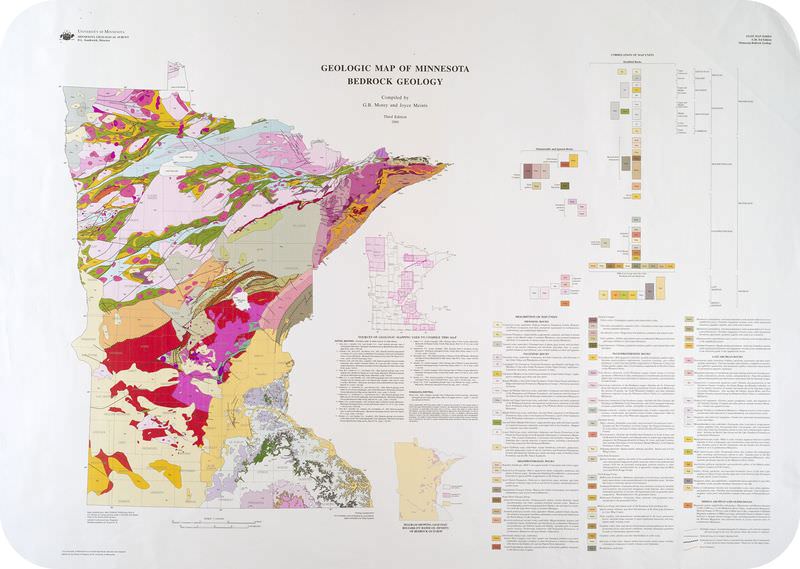
- Geologic maps detail the types and locations of found in an area.
::地质图详细列出了在某一区域内发现的种类和位置。
These are but a few types of maps that various Earth scientists might use. You can easily carry a map around in your pocket or bag. Maps are easy to use, because they are flat or two-dimensional. However, the world is three-dimensional. So, how do mapmakers represent a three-dimensional world on flat paper?
::这些地图只是地球科学家们可能使用的几种地图。你可以很容易地在口袋或包里携带地图。地图很容易使用,因为它们是平的或两维的。然而,世界是三维的。因此,地图制作者如何在平纸上代表三维的世界呢?Summary
::摘要- Maps are two-dimensional representations of a surface, usually Earth's.
::地图是表层的二维表示,通常是地球的。
- Maps use symbols and have legends. This is so they can display the most amount of information in the least amount of space.
::地图使用符号和传说。 这样他们就能显示最小空间中的最大数量的信息 。
- There are many types of maps. They can show social and political information; they can show scientific information.
::地图有多种类型,它们可以显示社会和政治信息;它们可以显示科学信息。
Review
::回顾- Using the road map of Florida ( Figure ), in what direction would you go to get from Fort Lauderdale to Tampa?
::使用Florida的路线图(图), 你会从劳德代尔堡到坦帕哪里去?
- Why do most maps begin with a portion of Earth's surface? When might they use something different as their base?
::为什么大多数地图都从地球表面的一部分开始? 它们什么时候可以用不同的东西作为基地?
- What types of maps are most useful to Earth scientists?
::哪些类型的地图对地球科学家最有用?
Explore More
::探索更多Use this resource to answer the questions that follow.
::使用此资源回答下面的问题 。- What does a geologic map show?
::地质地图显示什么?
- How does a geologist (who, BTW, can also be female) begin to create a geologic map?
::地质学家(BTW也可以是女性)如何开始绘制地质图?
- What is a topographic map?
::什么是地形图?
- How does a geologist make a geologic map from a topographic map?
::地质学家如何用地形图绘制地质图?
- What are aerial photographs? Why does a geologist use two of the same photographs side by side?
::航空照片是什么?为什么地质学家会同时使用两张相同的照片呢?
- What do each of the colors on a geologic map represent?
::地质图上的每个颜色代表什么?
- The boundaries of the state show its shape.