2.9地形图和地质图
章节大纲
-
Can a map help you understand a place even if you've never been there?
::地图能帮助你理解一个地方 即使你从未去过那里?Hills , streams , valleys , and snowfields all show up on some types of . With practice, people can look at a topographic map and see what the landscape is really like. Of course, it's not the same as being there! But a topographic map can give you a good feel for an area before you go. It can also help you to identify features once you are there. What does this map tell you about the region? Can you identify features that appear in the photo on the map?
::山、 溪、 河、 山谷、 雪地都出现在某类地貌上。 通过实践, 人们可以看到地形图, 并看一看地貌。 当然, 它和那里不同。 但是地形图可以让你在离开之前对一个区域有良好的感觉。 它也可以帮助您在到达那里后辨别特征。 这个地图告诉您关于这个区域的什么? 您能否辨别地图上的照片中显示的特征 ?Topographic Maps
::地形图The topography of a region can be shown on a map. Topographic maps represent geographical features, such as hills and valleys. Topographic maps use contour lines to show geographical features. A contour line is a line of equal . If you walk along a contour line, you will not go uphill or downhill. Topographic maps are also called contour maps. The rules of topographic maps are:
::一个区域的地形可以在地图上显示。地形图代表着地理特征,如山丘和山谷。地形图使用轮廓线显示地理特征。轮廓线是相等的线。如果沿着轮廓线行走,则不会上山或下坡。地形图也称为轮廓图。地形图的规则是:- Each line connects all points of a specific elevation.
::每条线连接特定海拔的所有点。
- Contour lines never cross. After all, a single point can only have one elevation.
::轮廓线从不交叉。毕竟,一个点只能有一个高度。
- Every fifth contour line is bolded and labeled.
::每五分之一的轮廓线都标有粗体和标签。
- Adjacent contour lines are separated by a constant difference in elevation (such as 20 feet or 100 feet). The difference in elevation is the contour interval . The contour interval is indicated in the map legend.
::相邻的等高线以恒定的海拔差异(如20英尺或100英尺)分隔。海拔的差异是等高间距。地图图例中标明了等高间距。
- Scales indicate horizontal distance and are also found on the map legend.
::缩放显示水平距离, 并在地图图例中找到 。
Interpreting Contour Maps
::翻译轮廓地图How does a topographic map tell you about the terrain? Let’s consider the following principles:
::地形图如何描述地形?让我们考虑以下原则:1. The spacing of contour lines shows the slope of the land . Contour lines that are close together indicate a steep slope. This is because the elevation changes quickly in a small area. Contour lines that seem to touch indicate a very steep slope, like a cliff. When contour lines are spaced far apart, the slope is gentle. So contour lines help us see the three-dimensional shape of the land.
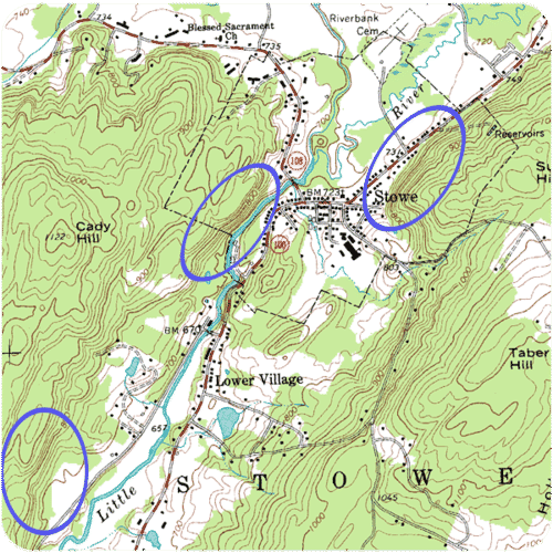
::1. 轮廓线的间距显示陆地的斜坡,相近的轮廓线显示的是陡坡,这是因为小区域的高度变化很快,似乎触动的轮廓线显示的是非常陡坡,如悬崖。当轮廓线相距遥远时,斜坡是温和的。轮廓线帮助我们看到陆地的三维形状。Look at the topographic map of Stowe, Vermont ( Figure ). There is a steep hill rising just to the right of the city of Stowe. You can tell this because the contour lines there are closely spaced. The contour lines also show that the hill has a sharp rise of about 200 feet. Then the slope becomes less steep toward the right.
::看看佛蒙特州斯托维的地形图(图 ) 。 有一个陡峭的山坡正向斯托维市的右方升起。 您可以看清楚这一点, 因为那里的轮廓线间距很近 。 轮廓线还显示, 山坡的高度上升大约200英尺。 然后, 坡坡向右的斜坡就变得不太陡峭了 。Portion of a USGS topographic map of Stowe, VT.
::美国地质测量局Stowe地形图,VT。2. Concentric circles indicate a hill . Pictured below is another side of the topographic map of Stowe, Vermont ( Figure ). When contour lines form closed loops, there is a hill. The smallest loops are the higher elevations on the hill. The larger loops encircling the smaller loops are downhill. If you look at the map, you can see Cady Hill in the lower left and another, smaller hill in the upper right.
::2. 中心圆圈表示一个山丘。下面的图象是佛蒙特州(图)斯托威地形图的另一侧。当轮廓线形成封闭环状时,有一个山丘,最小的环状是山顶的较高高高高高高高高高高高高的山丘。较小的环形环形环形环状是下坡。你看地图,可以看到左下角的卡迪山,右上角的又小的山丘。Portion of a USGS topographic map of Stowe, VT. Cady Hill (elevation 1122 feet) is shown by concentric circles in the lower left portion of the map. Another hill (elevation ~ 960 feet) is on the upper right portion of the map.
::VT. Cady Hill Stowwe(1122英尺高)的USGS地形图的一角(1122英尺高)在地图左下角以同心圆显示,另一座山(960英尺高)在地图右上部分。3. Hatched concentric circles indicate a depression . The hatch marks are short, perpendicular lines inside the circle. The innermost hatched circle represents the deepest part of the depression ( Figure ). The outer hatched circles represent higher elevations.
::3. 支离破碎的同心圆环表示抑郁。圆内舱口的标记短,直直线短。内部孵化的圆圈代表大萧条的最深部分(图 )。外部孵化的圆圈代表较高的海拔。On a contour map, a circle with inward hatches indicates a depression.
::在轮廓图上,带内舱盖的圆环表示抑郁症。4. V-shaped portions of contour lines indicate stream valleys . The “V“ shape of the contour lines point uphill. There is a V shape because the stream channel passes through the point of the V. The open end of the V represents the downstream portion. A blue line indicates that there is water running through the valley. If there is not a blue line, the V pattern indicates which way water flows. Below, you can see examples of V-shaped markings ( Figure ). Try to find the direction a stream flows.
::4. 等深线的V形部分表示河谷。等深线的 " V " 形状指向上坡点。由于河道穿过V点,所以有V形形状。V的开端表示下游部分。一条蓝线表示有流水穿过河谷,如果没有一条蓝线,V型表示水流的方向。下面,您可以看到V形标记的例子(图)。尝试找一条溪流的方向。Illustrations of three-dimensional ground configurations (top) and corresponding topographic map (bottom). Note that the V-shaped markings on the topographic maps correspond to drainage channels. Also, the closely-spaced contour lines denote the rapid rising cliff face on the left side.
::三维地面配置(顶部)和相应的地形图(底部)的说明。请注意,地形图上的V形标记与排水通道相对应。此外,近距离的轮廓线表示左侧悬崖面迅速上升。5. Like other maps, topographic maps have a scale so that you can find the horizontal distance . You can use the horizontal scale to calculate the slope of the land (vertical height/horizontal distance). Common scales used in United States Geological Service (USGS) maps include the following:
::5. 与其他地图一样,地形图有一个尺度,以便您找到水平距离,您可以使用水平尺度计算陆地的坡度(垂直高度/横向距离)。- 1:24,000 scale – 1 inch = 2000 feet
::1:24 000 比例尺-1英寸= 2000英尺
- 1:100,000 scale – 1 inch = 1.6 miles
::1:100 000 比例尺 - 1英寸= 1.6英里
- 1:250,000 scale – 1 inch = 4 miles
::1:250 000 比例尺 - 1英寸= 4英里
Including contour lines, contour intervals, circles, and V-shapes allows a topographic map to show three-dimensional information on a flat piece of paper. A topographic map gives us a good idea of the shape of the land.
::包括轮廓线、轮廓间距、圆圈和V形形状,使得地形图能够显示平面纸上的三维信息。地形图让我们很好地了解了陆地的形状。Geologic Maps
::地貌地图A geologic map shows the different that are exposed at the surface of a region. The geology is often put on a contour map. Rock units are shown in a color identified in a key. On the geologic map of the Grand Canyon, for example, different rock types are shown in different colors. Some people call the Grand Canyon “layer cake geology“ because most of the rock units are in layers. Rock units show up on both sides of a stream valley.
::地质图显示在区域表面暴露的不同区域。 地质学通常被放在轮廓图上。 岩石单位以在键中标明的颜色显示。 例如, 在大峡谷的地质图上, 不同的岩石类型以不同颜色显示。 一些人称大峡谷为“ 层蛋糕地质学 ” , 因为大部分岩石单位位于层层。 岩石单位出现在溪谷两侧 。A geologic map looks very complicated in a region where rock layers have been folded. are seen on this geologic map cutting across rock layers. When rock layers are tilted, you will see stripes of each layer on the map. There are symbols on a geologic map that tell you which direction the rock layers slant. Often there is a cut away diagram, called a cross section . A cross section shows what the rock layers look like below the surface. A large-scale geologic map will just show geologic provinces. They do not show the detail of individual rock layers.
::在一个岩石层被折叠的区域, 地质图看起来非常复杂。 这张地质图横跨岩石层。 当岩石层被倾斜时, 你可以看到地图上每个层的条纹。 地质图上有一些符号, 指示着岩石层倾斜的方向。 通常有一个切开的图表, 称为横截段。 一个横截段显示地表下岩层的外观。 一个大比例的地质图将显示地质区块。 它们不显示各个岩石层的详情 。A portion of the geologic map of the Grand Canyon, Arizona.
::亚利桑那大峡谷地质图的一部分Summary
::摘要- Topographic maps reveal the shape of a landscape. Elevations indicate height above sea level.
::地形图显示地貌的形状,海拔显示海拔高于海平面。
- Contour lines are lines of equal elevation. Contour intervals are the difference in elevation between two contour lines.
::轮廓线是等高线。轮廓间距是两条轮廓线之间的高度差异。
- Geologic maps show rock units and geologic features, like faults and folds.
::地质地图显示岩石单位和地质特征,如断层和折叠。
Review
::回顾- What is a contour line? What is a contour interval?
::什么是轮廓线?轮廓间距是什么?
- What will a hill look like on a topographic map? How will a basin look different from a hill?
::在地形图上,山像什么?盆地与山有何不同?
- How do contour lines indicate a steep slope? How do they indicate a stream?
::轮廓线如何表示陡坡?它们如何表示溪流?
- Why might a geologic map be useful to geologists?
::为什么地质图对地质学家有用?
Explore More
::探索更多Use the resource below to answer the questions that follow.
::利用以下资源回答以下问题。- What is sea level?
::海平面是什么?
- How far apart are topographic lines?
::地形线相距有多远?
- What do the contour lines represent?
::轮廓线代表什么?
- How do you know that there's a crater at the top of the volcano rather than a peak?
::你怎么知道火山顶上有一个火山坑 而不是山峰?
- What is the purpose of a topographic map?
::地形图的目的何在?
- Each line connects all points of a specific elevation.