2.10海底
章节大纲
-
Is it true that we know more about the dark side of the Moon than we do about the oceans?
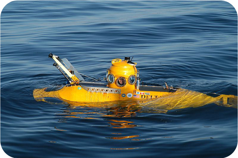
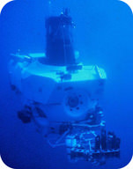
::我们是否真的对月球的黑暗面比对海洋更了解?It's true! Why do you think so? The oceans are deep, dark, and frigid. All but the very top surface is under extraordinarily high pressure. It's hard to imagine an environment that's less hospitable to human life! Yet, as you will see, we know quite a bit about the oceans. This is due mostly to technology. Rovers, like the one pictured above, allow scientists to remotely visit places that are too inhospitable for human life.
::这是真的!你为什么这么认为?海洋是深、暗和冷冷的。除了顶层表面之外,所有表面都受到极高的压力。很难想象一个对人类生活来说不太友好的环境。然而,正如你们将看到的那样,我们对海洋了解得相当多。这主要归功于技术。像上面所描绘的一样,流浪者允许科学家远程访问那些不适合人类生活的地方。Studying the Seafloor
::研究海底海底Scuba divers can only dive to about 40 meters. When they dive deep, they cannot stay down for very long. Therefore, scuba divers can only observe the organisms and ecosystems very near a coast. Most oceanic research requires accessing greater depths.
::潜水潜水员只能潜水到40米左右。潜水员深潜水时,不能停留很长时间。因此,潜水员只能观察离海岸很近的生物和生态系统。大多数海洋研究需要更深的深度。Seafloor Bathymetry
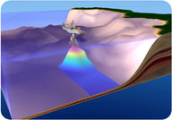
::海底水深测量How do scientists create bathymetric maps ? Early explorers mapped the seafloor by painstakingly dropping a line over the side of a ship. They measured the length of the line when it touched bottom. With this method, they could measure the depth, one tiny spot at a time. During World War II, battleships and submarines carried echo sounders . Echo sounders were developed to locate enemy submarines. Early echo sounders had a single beam. The beam bounced off the nearest object and then returned to the ship. Scientists know the speed of sound in seawater. They can then calculate the distance to the object based on the time it takes for the wave to make a round trip. This allowed them to create a line of depth measurements. Modern echo sounders produce sound waves that travel outward in all directions ( Figure ).
::科学家如何绘制测深图? 早期的探险家如何绘制测深图? 早期的探险家如何绘制海底图, 仔细地将一条线铺在船的侧面上。 当测深时, 他们测量了线的长度。 使用这种方法, 他们可以测量深度, 一次测量一个小点。 在二战期间, 战舰和潜艇携带回声探测器; 开发了回声探测器来定位敌潜艇。 早期回声探测器有一个光束。 早期回声探测器从最近的物体上跳出一个光束, 然后返回到船上。 科学家们知道海水中声音的速度。 然后, 他们可以根据波浪进行回转所需的时间计算到天体的距离。 这样他们就可以创建一条深度测量线。 现代回声仪产生向外向外的声波( 图表 ) 。This echo sounder has many beams and creates a three dimensional map of the seafloor.
::这个回声声仪有许多波束 绘制了海底三维地图Bathymetric Maps
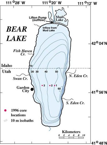
::测深图图Topographic maps that show water depths are called bathymetric maps . An example of one is pictured below ( Figure ). Bathymetric maps are made of any water body, including lakes and oceans. On these , the contour lines represent depth below the surface. Therefore, high numbers are deeper depths and low numbers are shallow depths.
::显示水深的地形图称为测深图,例如,图示如下(图示)。任何水体,包括湖泊和海洋,都有测深图。在这些图示上,等深线代表地表下的深度,因此,高深为高深,低深为浅深。Bathymetric maps are made from depth soundings or sonar data . They help oceanographers understand the shape of bottoms of lakes, bays, and the ocean. This information also helps boaters navigate safely.
::测深图是根据深度探测或声纳数据绘制的,有助于海洋学家了解湖泊、海湾和海洋底部的形状。这些信息也有助于渔船安全航行。Bathymetric map of Bear Lake, Utah.
::犹他州熊湖的测深图Water Sampling
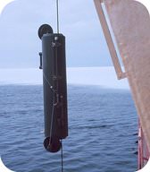
::水采样Scientists need to sample seawater (or lake water) from different depths. To sample seawater, bottles are placed along a cable at regular depths ( Figure ). When they are in position, a weight is dropped down the cable. This closes the bottles. The water trapped in the bottle can be analyzed in a laboratory. This allows scientists to understand ocean or lake chemistry.
::科学家需要从不同深度对海水( 或湖泊水) 进行取样。 要对海水进行取样,瓶子在正常深度( 图表 ) 沿电缆放置( 图表 ) 。 当它们处于位置时, 重量会降低到电缆下 。 这关闭了瓶子 。 瓶子里的水可以在实验室中分析。 这让科学家能够理解海洋或湖化学 。A Niskin bottle being deployed off the side of a research ship.
::一艘尼斯金瓶子被部署在研究船的一侧Scientists also collect and sediment samples from the seafloor. A dredge is a giant rectangular bucket that is dragged along behind a ship. The dredge picks up loose rocks lying on the seafloor. Gravity corers are metal tubes that fall to the seafloor. They slice into the sediments to collect a sample. The research vessel, the Joides Resolution , drills deep into the seafloor to collect samples of the sediment and ocean crust . Scientists analyze the samples for chemistry and their magnetic properties.
::深海钻探是一个巨型长方形桶,拖到船身后。挖掘挖取的岩石很松散,落在海底。重力岩芯是沉入海底的金属管,它们切入沉积物,采集样品。研究船Joides分辨率钻入海底深处,收集沉积物和海洋地壳的样品。科学家们分析了化学样品及其磁性。Submersibles
::潜水器Samples of seawater and rocks can be collected directly by scientists in a submersible . These subs can take scientists down to make observations. The subs have arms for collecting samples. The human operated vehicle, Alvin can dive up to 4,500 meters beneath the ocean surface and has made more than 5,000 dives since 1964 ( Figure ).
::科学家可以在潜水器中直接收集海水和岩石的样品。这些潜水器可以将科学家带下进行观察。潜水器有收集样品的武器。人类操作的潜水器Alvin可以潜水到海面下4 500米,并且自1964年以来已经潜水了5 000多次(图 )。Alvin allows two people and a pilot to make a nine hour dive.
::阿尔文允许两个人和一个飞行员 潜水九个小时Remotely Operated Vehicles
::遥控车辆Sending humans to the seafloor is expensive and dangerous. Having to return humans safely to the surface limits what a mission can do. Remotely operated vehicles , or ROVs, allow scientists to study the deep without going to the seafloor. These small vehicles carry cameras and scientific instruments. ROVs were used to study inside the Titanic . This would have been far too dangerous for a manned sub to enter. Scientists control ROVs electronically with sophisticated operating systems.
::将人类送入海底既昂贵又危险。 不得不安全地将人类送回到飞行任务所能达到的地表极限。 遥控飞行器或遥控飞行器允许科学家在不进行海底研究的情况下进行深层研究。 这些小型飞行器携带相机和科学仪器。 遥控飞行器被用于在泰坦尼克号内研究。 这对载人潜水器来说太危险了。 科学家们用先进的操作系统以电子方式控制遥控飞行器。Summary
::摘要- Scientists have developed amazing technologies so that they can understand the oceans.
::科学家们开发了惊人的技术 以便了解海洋
- Echo sounders use sound waves to make bathymetric maps of water bodies.
::声波声响器使用声波绘制水体测深图。
- Submersibles and ROVs allow scientists to view otherwise inhospitable regions.
::潜水器和遥控潜水器使科学家能够以其他方式查看不适宜居住的区域。
Review
::回顾- How does an echo sounder work?
::声音声音如何运作?
- Why is an ROV better for some tasks than a submersible?
::为什么遥控飞行器比潜水器更适合执行某些任务?
- How do marine geologists collect rock and sediment samples?
::海洋地质学家如何收集岩石和沉积物样本?
Explore More
::探索更多Use the resource below to answer the questions that follow.
::利用以下资源回答以下问题。- What is the only truly uncharted area of Earth?
::地球唯一真正未知的领域是什么?
- How were soundings taken in the past?
::过去的声音是怎么被拍下来的?
- List the advantages of using multi-beam sonar.
::列出使用多波束声纳的好处 。
- How is texture captured?
::纹理是如何被捕捉的?
- What is groundtruthing, and why is it necessary?
::什么是实情,为什么有必要呢?
- Why is this project important?
::为什么这个项目很重要?
- Scientists have developed amazing technologies so that they can understand the oceans.