9.3 巴基斯坦和孟加拉国(2天)
章节大纲
-
Chapter Challenges
::章次 挑战-
Outline how Pakistan and Bangladesh are similar in their populations and economic dynamics but different in their physical environments.
::概述巴基斯坦和孟加拉国的人口和经济动态如何相似,但物质环境不同。 -
Understand why the two countries were once under the same government and separated in 1972 when East Pakistan became Bangladesh.
::为何在1972年东巴基斯坦成为孟加拉时, 两国曾被同一政府统治, -
Describe the various regions of Pakistan and their physical and cultural landscapes.
::描述巴基斯坦各地区及其自然和文化景观。 -
Comprehend the impact that large populations have on the natural environment and outline the main environmental issues that confront these two countries.
::了解大量人口对自然环境的影响,概述这两个国家面临的主要环境问题。
Student Learning Objectives
::学生学习目标TEKS Regional Unit 09 South Asia: Chapter 9.3 Pakistan and Bangladesh
::TERS 区域股 09 南亚:第9.3章 巴基斯坦和孟加拉国WG.1A Analyze the effects of physical and human geographic patterns and processes on the past and describe their impact on the present, including significant physical features and environmental conditions that influenced migration patterns and shaped the distribution of culture groups today.
::WG.1A 分析物理和人类地理模式和过程对过去的影响,并描述其对目前的影响,包括影响移徙模式并影响当今文化群体分布的重要物理特征和环境条件。WG.2A Describe the human and physical characteristics of the same regions at different periods of time to evaluate relationships between past events and current conditions.
::WG.2A 描述不同时期同一区域的人的和自然的特征,以评估过去事件与当前状况之间的关系。WG.5A Analyze how the character of a place is related to its political, economic, social, and cultural elements.
::WG.5A 分析一个地方的特性如何与其政治、经济、社会和文化因素相关。WG.8B Describe the interaction between humans and the physical environment and analyze the consequences of extreme weather and other natural disasters such as El Niño, floods, tsunamis, and volcanoes.
::WG.8B 描述人类与自然环境之间的相互作用,分析极端天气和厄尔尼诺、洪水、海啸和火山等其他自然灾害的后果。WG9A Identify physical and/or human factors such as climate, vegetation, language, trade networks, political units, river systems, and religion that constitute a region.
::WG9A 查明构成区域的自然和/或人类因素,如气候、植被、语言、贸易网络、政治单位、河流系统和宗教。WG.10C Compare the ways people satisfy their basic needs through the production of goods and services such as subsistence agriculture versus commercial agriculture or cottage industries versus commercial industries.
::WG.10C 比较人们通过生产商品和服务满足其基本需要的方式,如自给农业,而不是商业农业或家庭手工业,而不是商业工业。WG.10D Compare global trade patterns over time and examine the implications of globalization.
::WG.10D 比较一段时间的全球贸易格局并审查全球化的影响。WG.13A Interpret maps to explain the division of land, including man-made and natural borders, into separate political units such as cities, states, or countries.
::WG.13A 解释地图,解释土地划分,包括人造边界和自然边界,分为不同的政治单位,如城市、州或国家。WG.14A Analyze current events to infer the physical and human processes that lead to the formation of boundaries and other political divisions.
::WG.14A 分析当前事件,以推断导致形成边界和其他政治分裂的物质和人类过程。WG.14C Analyze the human and physical factors that influence the power to control territory and resources, create conflict/war, and impact international political relations of sovereign nations.
::WG.14C 分析影响控制领土和资源的权力、造成冲突/战争以及影响主权国家国际政治关系的人力和物质因素。WG.15B Identify and give examples of different points of view that influence the development of public policies and decision-making processes on local, state, national, and international levels.
::WG.15B 查明并举例说明影响地方、国家、国家和国际各级公共政策和决策进程发展的不同观点。WG.16B Describe elements of culture, including language, religion, beliefs and customs, institutions, and technologies.
::WG.16B 描述文化要素,包括语言、宗教、信仰和习俗、机构和技术。WG.16C Explain ways various groups of people perceive the characteristics of their own and other cultures, places, and regions differently.
::WG.16C 解释不同群体对自身和其他文化、地方和区域特征的不同看法。WG.16D Compare life in a variety of urban and rural areas in the world to evaluate political, economic, social, and environmental changes.
::WG.16D 比较世界不同城市和农村地区的生活,以评价政治、经济、社会和环境变化。WG.18B Assess causes, effects, and perceptions of conflicts between groups of people, including modern genocides and terrorism.
::WG.18B 评估各群体之间冲突的原因、影响和看法,包括现代种族灭绝和恐怖主义。WG.22C Use geographic terminology correctly.
::WG.22C 正确使用地理术语。WG.22D Use standard grammar, spelling, sentence structure, and punctuation. [WG.22D]
::WG.22D 使用标准语法、拼写、句号结构和标点。 [WG.22D]Pakistan and Bangladesh
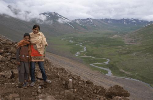
::巴基斯坦和孟加拉国Pakistan and Bangladesh are two separate and independent countries physically divided by India. Historically, this was not always the case: from 1947 to 1971 they were administered under the same government. The two countries share a number of attributes. They both have Muslim majorities and both have high population densities. The countries are two of the top 10 most populous countries in the world. Their populations are youthful and mainly rural.
::巴基斯坦和孟加拉国是两个由印度分裂的单独和独立国家。 从历史上看,情况并非总是如此:从1947年到1971年,它们都由同一个政府管理。 这两个国家有许多共同的属性,它们都拥有穆斯林多数,而且人口密度都很高。 这些国家是世界上人口最多的十大国家中的两个国家,它们的人口是年轻人,主要是农村人口。Agriculture is the main economic activity in each country. Rural-to-urban shift is a major trend affecting urban development. Infrastructure is lacking in many areas of each country. These similar factors indicate that both Pakistan and Bangladesh will face comparable challenges in providing for their large populations and protecting their natural environments.
::农业是每个国家的主要经济活动,农村向城市的转变是影响城市发展的一个主要趋势,每个国家的许多地区都缺乏基础设施,这些类似因素表明,巴基斯坦和孟加拉国在提供大量人口和保护自然环境方面都将面临类似的挑战。The Muslim League was responsible for the formation of a united Pakistan, a predominantly Muslim state for South Asian Muslims. Pakistan was created from the former Indian territories of Sindh, North West Frontier Provinces, West Punjab, Balochistan, and East Bengal. Pakistan was formed with two separate physical regions, defined by religious predominance. East Bengal, on the eastern side of India, was known as East Pakistan, while the remainder, separated by more than 1000 miles, was known as West Pakistan. The two physical units were united politically.
::穆斯林联盟负责组成一个统一的巴基斯坦,一个以穆斯林为主的南亚穆斯林国家,巴基斯坦是从前印度领土信德省、西北边境省、西旁遮普省、俾路支省和东孟加拉创建的,巴基斯坦由两个不同的自然区域组成,以宗教为主,印度东部的东孟加拉被称为东巴基斯坦,其余的被分隔1000多英里,称为西巴基斯坦,两个实体单位在政治上是统一的。East and West Pakistan, administered by one government, became independent in 1947 when Britain was forced out. Pakistan (East and West) adopted its constitution in 1956 and became an Islamic republic. In 1970, a massive cyclone hit the coast of East Pakistan and the central government in West Pakistan responded weakly to the devastation. The Bengali populations were angered over the government’s lack of consideration for them in response to the cyclone and in other matters.
::由一国政府管理的东巴基斯坦和西巴基斯坦于1947年在英国被赶走后获得独立。 巴基斯坦(东西方)于1956年通过了宪法并成为伊斯兰共和国。 1970年,一场大规模旋风袭击了东巴基斯坦海岸,西巴基斯坦中央政府对破坏反应不力。 孟加拉民众对政府缺乏对气旋和其他问题的考虑感到愤怒。The Indo-Pakistan War changed the situation. In this war, East Pakistan, with the aid of the Indian military, challenged West Pakistan and declared independence to become Bangladesh in 1972. West Pakistan became the current country of Pakistan.
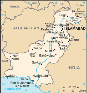
::印巴战争改变了局势。 在这场战争中,东巴基斯坦在印度军方的援助下挑战西巴基斯坦,1972年宣布独立成为孟加拉国。 西巴基斯坦成为目前的巴基斯坦国家。Pakistan
::巴基斯坦 巴基斯坦 巴基斯坦
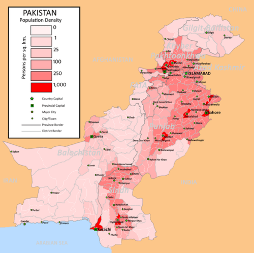
Map of Pakistan
::巴基斯坦地图图
The physical area of is equivalent to the US states of Texas and Louisiana combined. Much of Pakistan’s land area comprises either deserts or mountains. The high Himalayan ranges border Pakistan to the north. The lack of rainfall in the western part of the country restricts agricultural production in the mountain valleys and near the river basins. The Indus River flows roughly northeast/southwest along the eastern side of Pakistan, flowing into the Arabian Sea.
::巴基斯坦的大部分陆地面积包括沙漠或山岳。 喜马拉雅山脉高位与巴基斯坦北部接壤。 该国西部缺乏降雨限制了山区和河川流域附近的农业生产。 印杜斯河沿巴基斯坦东部的东北/西南流向阿拉伯海。The Cold Desert is a high-altitude desert located near Skardu, in Pakistan's northern Gilgit-Baltistan region.
::冷沙漠是位于巴基斯坦北部吉尔吉特-巴尔提斯坦地区的斯卡尔杜附近的高海拔沙漠。
River sediments are deposited in large areas found between river channels and oxbow lakes formed from the constantly changing river channels. These “lands between the rivers” are called “doabs” and represent some of the most fertile lands in the Indian subcontinent. The Indus River flows from the northern part of the Karakoram mountains and creates a large, fertile flood plain that comprises much of eastern Pakistan. Pakistan has traditionally been a land of farming. The Indus River Valley and Punjab are the dominant core areas where most of the people live and where population densities are remarkably high.
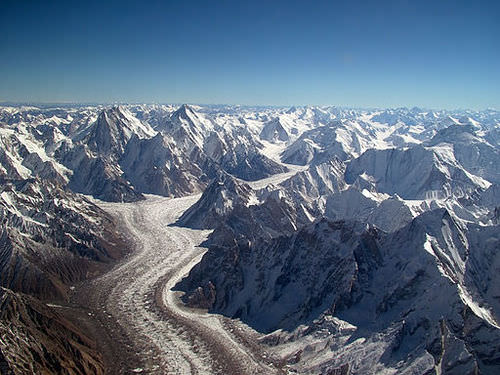
::河流沉积物沉积在河道与不断变化的河道形成的牛卵湖之间的大片地区,这些“河流之间的土地”被称为“doabs”,是印度次大陆上一些最肥沃的土地,印度河从卡拉科拉姆山脉北部流出,形成一个由巴基斯坦东部大部分地区组成的肥沃大洪泛平原,巴基斯坦历来是耕地,印度河谷和旁遮普是人口大多数居住和人口密度极高的主要核心地区。The Karakoram is a large mountain range spanning the borders of Pakistan, India, and China.
::卡拉科拉姆山脉是一座跨越巴基斯坦、印度和中国边界的大山脉。
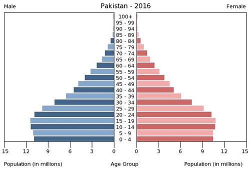
Approximately 64 percent of the population lives in rural areas and makes a living in agriculture. Most of the people are economically poor by world standards. In spite of the rural nature of the population, the average family size has decreased from seven to four in recent decades. Nevertheless, the population has exploded from about 34 million in 1951 to almost 205 million as of 2017. About half of the population is under the age of 20, and 35 percent is under the age of 15.
::大约64%的人口居住在农村地区,以农业为生,按照世界标准,大多数人在经济上生活贫穷,尽管人口属于农村性质,但近几十年来平均家庭规模从7个减少到4个,但人口从1951年的大约3 400万下降到2017年的近2.05亿,约一半的人口年龄在20岁以下,35%的人口年龄在15岁以下。United Nations Estimates of the Population of Pakistan
::联合国巴基斯坦人口估计数Total population (in thousands) Population aged 0–14 (%) Population aged 15–64 (%) Population aged 65+ (%) 1950 37,547 40.3 54.1 5.6 1955 41,109 40.3 54.8 4.9 1960 45,920 40.4 55.3 4.3 1965 51,993 41.6 54.5 3.9 1970 59,383 42.6 53.6 3.8 1975 68,483 43.2 53.1 3.7 1980 80,493 43.4 52.9 3.7 1985 95,470 43.4 52.9 3.8 1990 111,845 43.7 52.5 3.8 1995 127,347 43.3 52.9 3.8 2000 144,522 41.4 54.7 3.9 2005 158,645 38.1 57.8 4.1 2011 173,593 35.4 60.3 4.3
According to OECD/World Bank, the population in Pakistan increased by 23 million from 1990 to 2008, with a 54 percent growth in population.
::根据经合组织/世界银行的资料,巴基斯坦的人口从1990年至2008年增加了2 300万,人口增长了54%。
Age Structure of Pakistan: 0-14 years: 31.36 percent (male 33,005,623/female 31,265,463); 15-24 years: 21.14 percent (male 22,337,897/female 20,980,455); 25-54 years: 37.45 percent (male 39,846,417/female 36,907,683); 55-64 years: 5.57 percent (male 5,739,817/female 5,669,495); 65 years and over: 4.48 percent (male 4,261,917/female 4,910,094)
::巴基斯坦年龄结构:0-14岁:31.36%(男性33,005,623/女性31,265,463);15-24岁:21.14%(男性22,337,897/女性20,980,455);25-54岁:37.45%(男性39,846,417/女性36,907,683);55-64岁:5.57%(男性5,739,817/女性5,669,495);65岁及以上:4.48%(男性4,261,917/女性4,910,094)
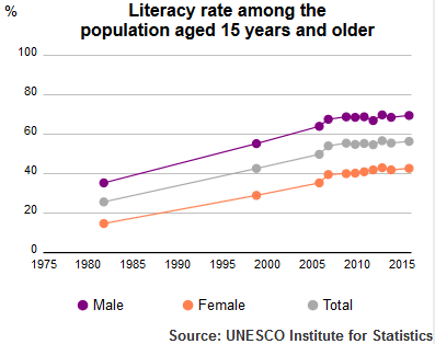
A lack of adequate medical care, an absence of family planning, and the low status of women have created an ever-increasing population, which will have dire consequences for the future of Pakistan. Service and infrastructure to address the needs of this youthful population are not available to the necessary degree. Schools and educational opportunities for children are rarely funded at the needed levels. As of 2015, (69.5 percent for men, and 45.8 percent for women).
::缺乏足够的医疗服务,缺乏计划生育,妇女地位低下,造成人口不断增加,这将给巴基斯坦的未来带来严重后果;满足这些年轻人口的需要的服务和基础设施不足;很少为儿童提供所需水平的学校和教育机会;截至2015年(男子为69.5%,妇女为45.8%)。Literacy rate of over-15 Pakistan population (1980–2015) by UNESCO Institute of Statistics.
::教科文组织统计研究所提供的巴基斯坦15岁以上人口的识字率(1980-2015年)。
Karachi was the capital of Pakistan when it was under British rule. Karachi is a port city located on the Arabian Sea. To establish a presence in the north, near Kashmir, the capital was moved to Islamabad in 1960. This example of a forward capital was an expression of geopolitical assertiveness by Pakistan against India. The lingua franca of the country for the business sector and the social elite continues to be English, even though Urdu is considered the national language of Pakistan and is used as a lingua franca in many areas. More than 60 languages are spoken in the country. There are as many ethnic groups in Pakistan as there are languages. The three most prominent ethnic groups are Punjabis, Pashtuns, and Sindhis.
::卡拉奇在英国统治时期是巴基斯坦的首都。卡拉奇是位于阿拉伯海的一个港口城市。为了在北部靠近克什米尔的地方建立存在,首都于1960年迁至伊斯兰堡。这个前方首都的例子表明巴基斯坦对印度的地缘政治固执。该国商业部门和社会精英的法语仍然是英语,尽管乌尔都语被认为是巴基斯坦的民族语言,在许多地区被用作法语。该国有60多种语言,巴基斯坦有同样多的族裔群体,而三个最突出的族裔群体是旁遮普族、普什图族和信德族。First languages of Pakistan Punjabi 48% Sindhi 12% Saraiki 10% Pashto 8% Urdu 8% Balochi 3% Others 11% Ethnic groups in Pakistan Punjabi 48% Sindhi 12% Saraiki 10% Pashto 8% Urdu 8% Balochi 3% Others 11% Regions of Pakistan
::巴基斯坦地区The three main physical geographic regions of Pakistan are the Indus River Basin, the Baluchistan Plateau, and the northern highlands. These physical regions are generally associated with the country’s main political provinces. The four main provinces include the Punjab, Balochistan, Sindh, and Khyber Pakhtunkhwa (North West Frontier).
::巴基斯坦的三个主要地理区域是印度河流域、俾路支海台和北部高原。 这些自然区域一般与巴基斯坦的主要政治省份有关。 四个主要省份包括旁遮普省、俾路支省、信德省和开伯尔帕赫图赫瓦省(西北边境 ) 。Moola Chotuk is a hidden paradise in Balochistan.
::Moola Chotuk是俾路支省一个隐蔽的天堂。
To the north is the disputed region of Kashmir known as the Northern Areas. Each of these regions represents a different aspect of the country. The North West Frontier has a series of Tribal Areas bordering Afghanistan that have been traditionally under their own local control. Agents under Tribal Agencies have attempted to administer some type of structure and responsibility for the areas, with little success.
::北部是克什米尔有争议地区,称为 " 北部地区 " ,每个地区代表着国家的不同方面,西北边境与阿富汗接壤的一系列部落地区传统上由它们自己控制,部落机构下属的代理人试图为这些地区管理某种结构和责任,但成效甚微。Punjab
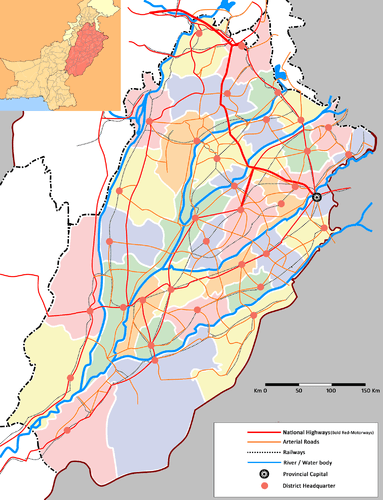
::旁遮普Map of the Province of Punjab in Pakistan, indicating districts, rivers, major and arterial roads and railways.
::巴基斯坦旁遮普省地图,标明各区、河流、主要公路和干道及铁路。List of major cities in Punjab
::旁遮普邦主要城市名单Rank City District Population 1 Lahore Lahore 14,500,000 2 Faisalabad Faisalabad 7,380,000 3 Rawalpindi Rawalpindi 5,891,656 4 Multan Multan 5,206,481 5 R.Y.Khan R.Y.Khan 4,814,006 6 Gujranwala Gujranwala 4,769,090 7 Sargodha Sargodha 4,557,514 8 Bahawalpur Bahawalpur 2,443,929 9 Sialkot Sialkot 1,910,863 10 Sheikhupura Sheikhupura 426,980 11 Jhang Jhang 372,645 12 Gujrat Gujrat 530,645 13 D.G.Khan D.G.Khan 630,645 Source: World Gazetteer 2010 This is a list of each city's urban populations and does not indicate total district populations
As explained previously, Punjab is a core area of Pakistan, and has about 60 percent of Pakistan’s population. The five rivers of Punjab border India and provide the fresh water necessary to grow food to support a large population. Irrigation canals create a water management network that provides water throughout the region. The southern portion of Punjab includes the arid conditions of the Thar Desert.
::如前所述,旁遮普省是巴基斯坦的核心地区,占巴基斯坦人口的60%左右。 旁遮普省与印度接壤的五条旁遮普省河流提供了种植粮食所需的淡水,以养活大量人口。 灌溉运河在全地区建立了供水管理网络。 旁遮普省南部包括塔尔沙漠的干旱条件。The northern sector includes the foothills of the mountains and has cooler temperatures in the higher elevations. Punjab is anchored by the cities of Lahore, Faisalabad, and Multan. Lahore is the cultural center of Pakistan and is home to the University of the Punjab and many magnificent mosques and palaces built during its early history.
::拉合尔是巴基斯坦的文化中心,是旁遮普大学的所在地,也是古代古代许多宏伟的清真寺和宫殿的所在地。The University of Lahore is a private university located in Lahore, Punjab, Pakistan.
::拉合尔大学是一所私立大学,位于巴基斯坦旁遮普省拉合尔。
In the 1980s, many Punjabis migrated to Europe, the Middle East, and North America seeking opportunities and employment. This diaspora of people from Punjab provided cultural and business ties with Pakistan. For example, trade connections between Punjab and the United States are increasing.
::1980年代,许多旁遮普人移民到欧洲、中东和北美寻找机会和就业。 旁遮普人散居在外,他们与巴基斯坦建立了文化和商业联系。 比如,旁遮普与美国之间的贸易联系正在增加。Punjab is the most industrialized of all the provinces. Manufacturing has increased with industries producing everything from vehicles to electrical appliances to textiles. The industrialization of Punjab is an indication of its skilled workforce and the highest literacy rate in Pakistan, at about 80 percent.
::旁遮普省是所有省份中工业化程度最高的省份。 制造业随着从汽车到电器到纺织品等一切生产行业的产业的出现而增长。 旁遮普省工业化表明其熟练劳动力和巴基斯坦最高识字率(约80% ) 。Balochistan
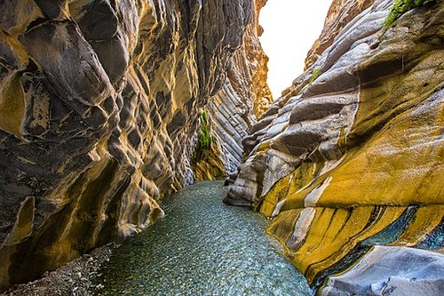
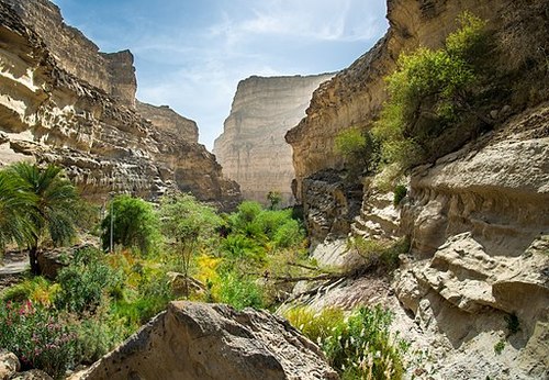
::俾路支Balochistan Canyons
::俾路支峡谷
Balochistan encompasses a large portion of southwest Pakistan to the west of the Indus River. The region connects the Middle East and Iran with the rest of Asia. The landscape consists of barren terrain, sandy deserts, and rocky surfaces. Balochistan covers about 44 percent of the entire country and is the largest political unit. The sparse population ekes a living out of the few mountain valleys where water can be found.
::俾路支省包括印度河以西的巴基斯坦西南大部分地区,该地区连接中东和伊朗与亚洲其他地区,地貌景观包括贫瘠的地形、沙沙沙漠和岩石表面。俾路支省占全国面积的大约44%,是最大的政治单位。 稀少的人口生活在能够找到水的少数山谷之外。Local politics provides the basic structure for society in this region. Within the Balochistan province of Pakistan are several coastal and interior rivers. The interior rivers flow from the Hindu Kush Mountains of Afghanistan, while most of the rivers along the coastal deserts from west of Karachi to the Iranian border are seasonal in nature and provide one of the few sources of fresh water in those coastal regions. Much of the coastal region is arid desert with sand dunes and large volcanic mountainous features.
::巴基斯坦俾路支省内有几条沿海河和内河,内河从阿富汗兴都库什山流出,而沿卡拉奇以西沿海沙漠到伊朗边界的大部分河流是季节性的,是这些沿海地区为数不多的淡水来源之一。The Sindh
::信德人The Sindh region of the southeast is anchored by Karachi, Pakistan’s largest city and major port. The Indus River is the border on the west and the Punjab region lies to the north. To the east of the Sindh is the border with India and the great Thar Desert. The Sindh is a region that misses out on the rains from the summer monsoon and the retreating monsoon season when the winds sweep in from the north over South Asia.
::东南部信德省以巴基斯坦最大的城市和主要港口卡拉奇为锚定地,印度河是西部的边界,旁遮普省地区位于北部,信德省以东是印度和大塔尔沙漠的边界。 信德省是一个因夏季季风雨和季风季节从北面吹过南亚后退而漏雨的地区。The city of Hyderabad , Pakistan, is located along the Indus River, which is a key food-growing area. Food crops consist of wheat and other small grains, with cotton as a major cash crop that helps support the textile industry of the region.
::巴基斯坦海得拉巴市位于印度河沿岸,这是一个重要的粮食种植区,粮食作物包括小麦和其他小谷物,棉花是主要的经济作物,有助于支持该区域的纺织业。Rural-to-urban shift has pushed large numbers of Sindh residents into the city of Karachi to look for opportunities and employment. In previous sections, slums and shantytowns have been described and explained for cities such as Mexico City and São Paulo. Karachi has similar development patterns. The central business district has a thriving business sector that anchors the southern part of the country. The city has a large port facility on the Arabian Sea.
::农村向城市的转变促使大批信德人进入卡拉奇市寻找机会和就业,在前几节中,对墨西哥城和圣保罗等城市的贫民窟和棚户区作了描述和解释,卡拉奇也有类似的发展模式,中央商业区有一个兴旺的商业部门,为该国南部提供支柱,该市在阿拉伯海拥有一个大型港口设施。As a city of 12 to 15 million people or more, there are always problems with a lack of public services, law enforcement, or adequate infrastructure. Urban centers usually have a strong informal economy that provides a means for many of the citizens to get by but is outside the control of the city or national government. The Sindh is the second most populous region of Pakistan, after Punjab.
::作为拥有1,200万至1,500万人口或以上人口的城市,总是有缺乏公共服务、执法或适当基础设施的问题。 城市中心通常拥有强大的非正规经济,它为许多公民提供了一条通路,但不受城市或国家政府控制。 信德省是巴基斯坦仅次于旁遮普省的人口第二多的地区。Khyber Pakhtunkhwa (The North West Frontier)
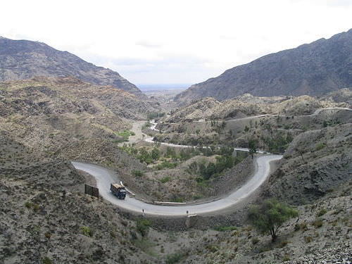
::Khyber Pakhtunkhwa(西北边境)The North West Frontier is a broad expanse of territory that extends from the northern edge of Baluchistan to the Northern Areas of the former Kingdom of Kashmir. Sandwiched between the tribal areas along the Afghanistan border and the well-watered lands of Punjab, the Khyber Pakhtunkhwa Province is dominated by remote mountain ranges with fertile valleys. The famous Khyber Pass, a major chokepoint into Afghanistan, is located here.
::西北边境是从俾路支北部边缘延伸到前克什米尔王国北部地区的广阔领土。 沿阿富汗边界的部落地区与旁遮普省水源良好的土地之间,开伯尔-普赫图赫瓦省以边远山区为主,有肥沃的山谷。 著名的开伯尔山口是阿富汗的一个主要阻塞点。The Khyber Pass (elevation: 3,510 ft) is a mountain pass in the north of Pakistan, close to the border with Afghanistan.
::开伯尔山口(海拔:3 510英尺)是巴基斯坦北部靠近阿富汗边界的一座山口。
The frontier is a breeding ground for anti-Western culture and anti-American sentiments, mainly fueled by the US military activity in Afghanistan. The Taliban movement that once controlled the government of Afghanistan has been active and generally more organized in this region than in Afghanistan. A push for more fundamentalist Islamic law has been a major initiative of the local leaders. Support for education and modernization is minimal. The government of Pakistan has also stepped up its military actions in the region to counter the activities of the militant Islamic extremists.
::边境是反西方文化和反美情绪的温床,主要由美国在阿富汗的军事行动火上浇油。 曾经控制阿富汗政府的塔利班运动在该地区比在阿富汗活跃,组织起来普遍更多。 推行更加原教旨主义的伊斯兰法是当地领导人的一项重大举措。 对教育和现代化的支持微乎其微。 巴基斯坦政府还在该地区加紧军事行动,打击好战的伊斯兰极端分子的活动。The Tribal Areas
::部落地区Federally Administered Tribal Areas (FATA)
::联邦直辖部落地区(FATA)
The North West Frontier borders the Tribal Areas, where clans and local leaders are standard parts of the sociopolitical structure. These remote areas have seldom been fully controlled by either the colonial governments (the British) or the current government of Pakistan. There are about seven main areas that fall under this description. Accountability for the areas has been difficult and even when the national government stepped in to exercise authority, there was serious resistance that halted any real established interaction.
::西北边境与部落地区接壤,部落和地方领导人是社会政治结构的标准组成部分,这些偏远地区很少完全由殖民政府(英国)或巴基斯坦现政府控制,大约有七个主要地区属于这一范畴,对这些地区的问责一直很困难,即使国家政府介入行使权力,也存在着严重抵抗,阻碍了任何真正的既定互动。These remote areas are where groups such as al-Qaeda and the Taliban often find a safe haven. South and North Waziristan are two of the main areas that have been controlled by Tribal Agencies and not directly by the Pakistani government.
::这些偏远地区是“基地”组织和塔利班等团体往往找到安全避难所的地方。 南部和北瓦济里斯坦是部落机构控制而非巴基斯坦政府直接控制的两个主要地区。
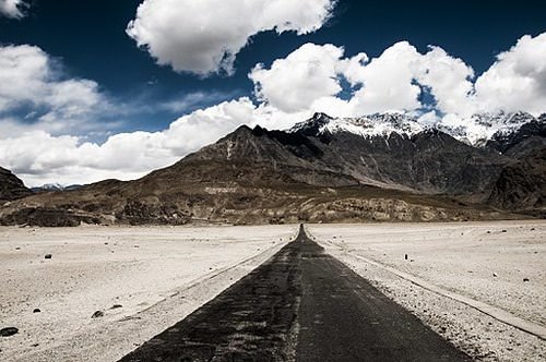
Northern Areas with Disputed Kashmir
::与克什米尔有争议的北部地区Pakistan’s Northern Areas include the territories that were once part of the Kingdom of Kashmir, the boundaries of which are disputed with India. The region is, in other words, interconnected with the issues related to Kashmir that involve Pakistan, India, and China. There are two main political entities: the large northern section bordering Afghanistan is called Gilgit-Baltistan, and the narrow section near Islamabad is called Azad Kashmir (Azad Jammu and Kashmir).
::巴基斯坦的北部地区包括曾经是克什米尔王国一部分的领土,其边界与印度有争议。 换句话说,该地区与涉及巴基斯坦、印度和中国的克什米尔问题相关联。 有两个主要政治实体:与阿富汗接壤的北部大片地区被称为吉尔吉特-巴尔提斯坦,伊斯兰堡附近的狭窄地区被称为阿扎德克什米尔(查谟和克什米尔 ) 。The Northern Areas are highlands, bordered to the north by the towering Karakoram and Pamir mountain ranges. K2, the world’s second highest mountain, which reaches 28,250 feet, is located here. The Northern Areas are sparsely populated except for the Indus River valley. The conflicts over these territories fuel nationalistic forces in both Pakistan and India.
::北部地区是高地,北邻卡拉科拉姆和帕米尔山脉。 K2是世界第二大山,面积达28 250英尺,位于这里。 北部地区人口稀少,印度河谷除外。 这些地区的冲突加剧了巴基斯坦和印度的民族主义力量。The conflicts are as much between Islam and Hinduism as they are between political factions. The early war between India and Pakistan over the border that the British placed between them in 1947 almost seems to be reenacted in the more recent conflicts over the region of Kashmir.
::伊斯兰和印度教之间的冲突同政治派别之间的冲突一样多。 印度和巴基斯坦之间就1947年英国在两国间划定的边界进行的早期战争似乎在克什米尔地区最近发生的冲突中再次爆发。The Highlands of the Northern Areas in Pakistan.
::巴基斯坦北部地区高地。R eligion and Politics in Pakistan
::巴基斯坦的宗教和政治Today most of the people living in Pakistan are Muslim. About 85 percent of the Muslim population in Pakistan is Sunni and about 15 percent of the Muslim population is Shia, which is consistent with the percentages of the two Islamic divisions worldwide. Islam is considered the state religion of Pakistan. The state is a federal republic with a parliamentarian style of government.
::今天,生活在巴基斯坦的大多数人是穆斯林,巴基斯坦的穆斯林人口约85%是逊尼派,穆斯林人口约15%是什叶派,这与全世界两个伊斯兰分裂的比例是一致的。伊斯兰教被认为是巴基斯坦的国教。国家是一个联邦制共和国,具有议会式的政府风格。As an Islamic state following the Sharia laws of the Koran, it has been a challenge for Pakistan to try to balance instituting democratic reforms while staying true to fundamental Islamic teachings. Pakistan has held elections for government leaders, and the status of women has improved. Women have held many governmental and political positions, including prime minister.
::作为遵循《古兰经》伊斯兰教教法的伊斯兰国家,巴基斯坦面临的挑战是努力平衡实行民主改革,同时坚持基本的伊斯兰教义。 巴基斯坦举行了政府领导人选举,妇女地位也有所改善。 妇女担任了许多政府和政治职务,包括总理。The military has been a foundation of power for those in charge. As a result of weak economic conditions throughout the country, it has been the military that has received primary attention and is the strongest institution within the government. Pakistan has demonstrated its nuclear weapons capability in recent years, which established it as a major player in regional affairs.
::军队是掌权者的权力基础,由于全国经济条件薄弱,军队受到首要关注,是政府内部最强大的机构,近年来巴基斯坦展示了核武器能力,使其成为地区事务的主要参与者。Pakistan has suffered from inadequate funding for public schools. As a rule, the wealthy urban elites have been the only families who could afford to send their children to college. With half the population consisting of young people, there are few opportunities to look forward to in Pakistan. Education has been supported in the form of Islamic religious schools called madrassas, which teach children the Koran and Islamic law.
::巴基斯坦公立学校经费不足,通常只有富裕的城市精英家庭有能力送子女上大学,有一半人口是年轻人,巴基斯坦几乎没有什么机会期待。 巴基斯坦以伊斯兰宗教学校的形式支持教育,即伊斯兰宗教学校(伊斯兰学校),向儿童教授可兰经和伊斯兰法。Much of the funding for religious schools comes from outside sources such as Saudi Arabia. The result is a religious education that does not provide the skills needed for the modern world. Pakistan has worked to build schools, colleges, and universities to educate its people. The situation is that population growth has been outpacing what little budget was allocated for educational purposes.
::宗教学校的大部分资金来自外部来源,如沙特阿拉伯,其结果是宗教教育没有提供现代世界所需的技能,巴基斯坦努力建设学校、学院和大学教育人民,人口增长的速度超过了为教育目的划拨的预算。The government of Pakistan has struggled to meet the challenge posed by the democratic structure of its constitution. The combination of a federal republic and an Islamic state creates a unique and at times difficult balance in administrative politics. The legislative body of Pakistan consists of a National Assembly and a Senate. The leader of the National Assembly is the prime minister.
::巴基斯坦政府努力应对其宪法的民主结构带来的挑战,联邦共和国和伊斯兰国家相结合,在行政政治方面形成了独特的、有时是困难的平衡。 巴基斯坦立法机构由国民议会和参议院组成。 国民议会的领导人是总理。The elected president not only is in charge of the military but is also head of state. The military establishment and the Inter-Services Intelligence (ISI) agency hold major political power in Pakistan. The political leadership has often vacillated between military and civilian rule. Transitions between the two types of leadership have been conducted through civil unrest or political demonstrations in the streets.
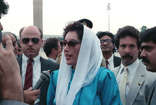
::当选总统不仅负责军队,而且也是国家元首。 军事机构和三军情报局(ISI)机构在巴基斯坦拥有主要的政治权力。 政治领导层常常在军事统治和文官统治之间摇摆不定。 这两类领导层之间的过渡是通过内乱或街头政治示威进行的。Benazir Bhutto: The First Female Prime Minister of Pakistan
::贝娜齐尔·布托:巴基斯坦第一女总理Women’s roles in Pakistani leadership have been complex. To understand the impact of electing the first woman prime minister in Pakistan, one has to go back to 1972. At that time, East Pakistan gained its independence and changed its name to Bangladesh. At roughly the same time, Pakistan elected President Zulfikar Ali Bhutto to power. After ruling for five years, Zulfikar Ali Bhutto was ousted from power and sentenced to death by General Zia, who became the next president.
::女性在巴基斯坦领导层的角色是复杂的。 要了解巴基斯坦选举第一位女总理的影响,就必须追溯到1972年。 当时,东巴基斯坦获得了独立并改名为孟加拉国。 大约与此同时,巴基斯坦选举了祖勒菲卡尔·阿里·布托总统掌权。 在执政五年后,祖勒菲卡尔·阿里·布托被下任总统齐亚将军推翻并判处死刑。General Zia was the first military general to also be president. He allowed the Islamic Sharia law to be introduced into the legal system, which bolstered the influence of Islam on the military and government services. In 1988, General Zia was killed in an unexplained plane crash. The daughter of the first president—Zulfikar Ali Bhutto—was then elected as prime minister. The 35-year-old Benazir Bhutto was the first female prime minister of Pakistan.
::齐亚将军也是第一位担任总统的将军,他允许将伊斯兰教法引入法律制度,这加强了伊斯兰教对军事和政府服务的影响。 1988年,齐亚将军在一次不明原因的空难中丧生。 第一任总统阿里·布托的女儿后来当选为总理。 35岁的贝娜齐尔·布托是巴基斯坦第一位女总理。Benazir Bhutto on a visit to Washington, D.C. in 1989.
::贝娜齐尔·布托于1989年访问华盛顿特区。
Benazir Bhutto’s tenure as prime minister was short-lived. After a year and a half, the president removed her from office on accusations of corruption. She ran again in 1993 and was reelected to the prime minister position. Charges of corruption continued and she was removed as prime minister a second time in 1996. Political corruption, or the accusations of such a charge, is not uncommon in Pakistan or other countries with volatile political situations.
::贝娜齐尔·布托的总理任期短短。 一年半后,总统以腐败罪名辞去总统职务。 1993年,她再次竞选总理,并再次当选总理。 腐败指控仍在继续,1996年,她第二次被解除总理职务。 巴基斯坦或其他政局动荡的国家,政治腐败或对此类指控的指控并不罕见。To keep from being prosecuted by her opposition, Benazir Bhutto left Pakistan in 1998 and lived in Dubai. She did not return to Pakistan until 2007, under an agreement reached with the military general who was president at the time, General Pervez Musharraf. Benazir Bhutto was given amnesty for any and all claims against her.
::为了避免受到反对派的起诉,贝娜齐尔·布托于1998年离开巴基斯坦,住在迪拜,她直到2007年才根据与当时担任总统的将军佩尔韦兹·穆沙拉夫将军达成的协议返回巴基斯坦,贝娜齐尔·布托因针对她的任何和所有指控而被赦免。The elimination of the corruption charges against her allowed Benazir Bhutto to become a candidate for the office of president. She organized an effective campaign. Her campaign for the presidency energized the political landscape of the country. In December of 2007, her campaign was cut short. Benazir Bhutto was assassinated after departing a political rally.
::她组织了一个有效的竞选活动,她竞选总统的竞选活动为国家的政治风气注入了活力。 2007年12月,她的竞选活动被中断。 贝娜齐尔·布托在退出政治集会后被暗杀。She was assassinated a few weeks before the polls were to open for the election. Benazir Bhutto was the leading opposition candidate. Her death rallied support against General Musharraf with continued calls for his removal from office. General Musharraf resigned from the presidency in 2008. The winner of the presidential elections that followed was none other than Benazir Bhutto’s husband, Asif Ali Zardari. President Zardari blamed the Taliban for the assassination of his wife.
::贝娜齐尔·布托是主要反对党候选人。 她的死与穆沙拉夫将军的死联系在一起,不断呼吁解除总统职务。 穆沙拉夫将军于2008年辞去总统职务。 随后的总统选举获胜者是贝娜齐尔·布托的丈夫阿西夫·阿里·扎尔达里。 扎尔达里总统指责塔利班暗杀他的妻子。Environmental Issues in Pakistan
::巴基斯坦环境问题Pakistan is confronted with severe environmental issues. One of the concerns is a fault zone that runs directly through the region. Pakistan’s regions are divided by the Eurasian tectonic plate and the Indian tectonic plate. Shifting tectonic plates cause earthquakes, and there have been several major ones in Pakistan’s recent history. For example, an earthquake of 7.6 magnitude in 2005 in the northern region of the North West Frontier claimed about 89,000 lives in Pakistan and a few thousand others in neighboring India and Afghanistan.
::巴基斯坦面临着严重的环境问题。 其中一项关注是直接横跨该地区的断层区。 巴基斯坦的地区被欧亚构造板块和印度构造板块分割开来。 改变构造板块引发地震,巴基斯坦近代历史上也曾发生过几起重大地震。 比如,2005年西北边境北部地区的7.6级地震在巴基斯坦夺走了约89,000人的生命,在邻国印度和阿富汗也夺走了数千人的生命。About 150 aftershocks were felt the next day, many of which were over the 6.0 level on the Richter scale. This particular event in 2005 was listed as the 14th most devastating earthquake on record at the time. It left over three million people without a home in Pakistan alone and more people were left homeless in neighboring areas. Hardest hit outside of Pakistan was the portion of Kashmir that is controlled by India.
::第二天,大约150次余震受到冲击,其中多数超过里氏6.0级,2005年这一特别事件被列为当时记录的第14次最具破坏性的地震,使300多万人独自在巴基斯坦没有家,更多的人无家可归,巴基斯坦境外最惨重的冲击是印度控制的克什米尔地区。Many countries, including the United States, stepped up and supported the aid effort to reach people in the devastated region. Major earthquakes that cause devastation for the large populations here are common along this tectonic plate boundary.
::许多国家,包括美国,都加紧并支持援助努力,以援助灾区人民。 给这里大量人口造成破坏的重大地震在这片构造板块边界上司空见惯。Another environmental issue in Pakistan is water pollution. Raw sewage discharges into the rivers and streams and contaminates the drinking water for many Pakistanis. Most of the population lives in rural areas and relies on natural untreated water for their consumption. The water sources are heavily polluted, triggering disease and health problems.
::巴基斯坦的另一个环境问题是水污染,污水排放到河流和溪流中,污染许多巴基斯坦人的饮用水,大部分人口生活在农村地区,依靠未经处理的自然水消费,水源污染严重,引发疾病和健康问题。The urban areas lack public water works to handle fresh water supplies or to dispose of sewage properly. Industrial wastes and agricultural runoff also pollute and damage water supplies. Floods and natural runoff can carry pollutants from the land or urban areas into the rivers and streams that are used by human communities. The net effect of all these factors is that the majority of Pakistan’s population lacks safe drinking water.
::城市地区缺乏处理淡水供应或适当处理污水的公共供水工程;工业废物和农业径流也污染和破坏供水;洪水和自然径流可能将污染物从土地或城市地区带入人类社区使用的河流和溪流;所有这些因素的净影响是巴基斯坦大部分人口缺乏安全饮用水。Deforestation is another environmental problem in Pakistan because the demand for wood for cooking fuel and building is on the rise. Only about 2.5 percent of Pakistan is forested. In the last two decades, Pakistan has lost about one-fourth of its forest cover. The removal of forests causes widespread soil erosion during heavy rains and decreases natural habitat for organisms and wild animals.
::砍伐森林是巴基斯坦的另一个环境问题,因为木柴对烹饪燃料和建筑的需求正在上升。只有约2.5%的巴基斯坦是森林。 在过去20年中,巴基斯坦丧失了大约四分之一的森林覆盖。 森林的清除在暴雨中造成大面积土壤侵蚀,生物和野生动物的自然栖息地减少。Efforts to protect the biodiversity of the country have been minimal and are complicated by the increase in population, which is expected to double in about 45 years if population growth remains on its current trajectory. The reality is that deforestation is likely to continue in Pakistan, with little hope of a solution anytime soon.
::保护国家生物多样性的努力是微乎其微的,而且由于人口增长而变得复杂。 如果人口增长保持目前的轨迹,预计人口将在45年内翻一番。 现实是,在巴基斯坦,毁林现象很可能继续下去,而很快找到解决办法的希望渺茫。Bangladesh
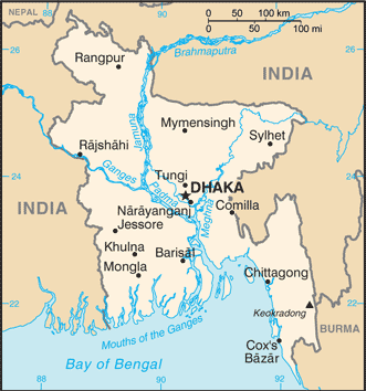
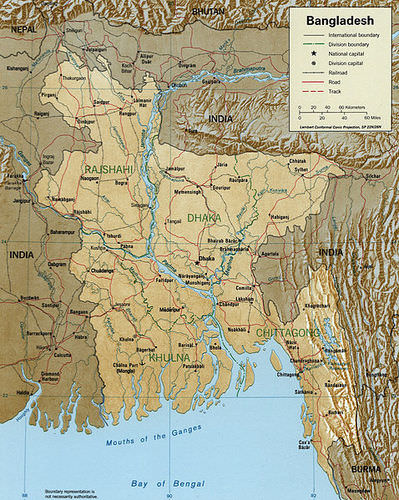
::孟加拉国 孟加拉国
Map of Bangladesh
::孟加拉国地图
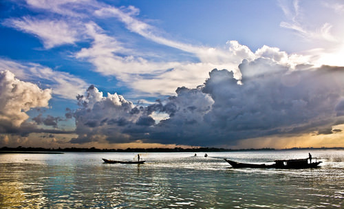
is a low-lying country that is associated with the types of marshy environments found in tropical areas and river deltas. The region is extremely prone to flooding, particularly during the monsoon season because of the high amount of rainfall. One of the most important rivers of Bangladesh flows southward from the Himalayas through India and into Bangladesh. While in India, this river is known as the Brahmaputra River, but when it enters Bangladesh, it is known as the Jamuna River. It provides a major waterway for this region and empties into the Bay of Bengal.
::孟加拉国是一个低洼国家,与热带地区和河三角洲的沼泽环境类型有关,该区域极易发生洪水,特别是在季风季节,因为降雨量大,孟加拉国最重要的河流之一从喜马拉雅山脉向南流经印度和孟加拉国,在印度,这条河流被称为布拉马普特拉河,但进入孟加拉国时,它被称为贾穆纳河,为该地区提供了一条主要水道,并流入孟加拉湾。Rivers of Bangladesh, including the Brahmaputra.
::孟加拉国的河流,包括布拉马普特拉河。
Contributing to the immense flow of water through the country are the Ganges and the Meghna rivers, which join up with the Brahmaputra River near the sea. The Ganges flows through northern India and is a major source of fresh water for a large population before it reaches Bangladesh.
::恒河和Meghna河是该国水流量巨大的原因之一,它们与靠近海洋的布拉马普特拉河汇合在一起,而恒河通过印度北部流经印度北部,是大批人口在到达孟加拉国之前的淡水的主要来源。The Meghna is a collection of tributaries within the boundaries of Bangladesh that flows out of the eastern part of the country. The Meghna is a deep river that can reach depths of almost 2,000 feet with an average depth of more than 1,000 feet. The hundreds of water channels throughout the relatively flat country provide for transportation routes for boats and ships that move goods and people from place to place. There are few bridges, so land travel is restricted when rainfall is heavy.
::Meghna河是孟加拉国边界内从该国东部流出的一系列支流。Meghna河是一条深河,可以达到近2 000英尺的深度,平均深度超过1 000英尺。在整个相对平坦的国家里,数百条水道为将货物和人员从其他地方运到其他地方的船只和船只提供交通路线。没有几座桥梁,因此降雨量大时陆路旅行受到限制。The Meghna River is one of the most important rivers in Bangladesh.
::Meghna河是孟加拉最重要的河流之一。Population and Globalization
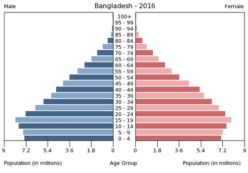
::人口与全球化Imagine a country the size of the US state of Wisconsin. Now imagine half of the entire population of the United States living within its borders. With an estimated population of about 161.1 million in 2012 and a land area of only 55,556 square miles, it is one of the most densely populated countries on the planet.
::想象一下美国威斯康辛州的规模。 现在,想象一下美国总人口的一半生活在其边界内。 2012年,美国人口估计约为1.611亿,国土面积仅为55,556平方英里,因此,它是世界上人口最稠密的国家之一。Population (millions) Year Population Per Annum Growth Rate 1971 67.8 — 1980 80.6 +1.94% 1990 105.3 +2.71% 2000 129.6 +2.10% 2010 148.7 +1.38% 2012 161.1 +4.09% Source: OECD/World Bank Age Structure of Bangladesh: 0-14 years: 27.76 percent (male 22,283,780 / female 21,521,977); 15-24 years: 19.36 percent (male 15,309,543 / female 15,241,971); 25-54 years: 39.73 percent (male 30,094,014 / female 32,614,286); 55-64 years: 6.93 percent (male 5,405,900 / female 5,527,330); 65 years and over: 6.23 percent (male 4,666,033 / female 5,161,744)
::孟加拉国年龄结构:0-14岁:27.76%(男性22 283 780/女性21 521 977);15-24岁:19.36%(男性15 309 543/女性15 241 971);25-54岁:39.73%(男性30 094 014/女性32 614 286);55-64岁:6.93%(男性5 405 900/女性5 527 330);65岁及以上:6.23%(男性4 666 033/女性5 161 744)
Most of the population in Bangladesh is rural, agriculturally grounded, and poor. The larger cities, such as the capital of Dhaka, have modern conveniences, complete with Internet cafes, shopping districts, and contemporary goods. The rural areas often suffer from a lack of adequate transportation, infrastructure, and public services.
::孟加拉国大部分人口是农村人口、农业人口和穷人,如达卡省会等大城市拥有现代便利设施,配有网吧、购物区和当代商品,农村地区往往缺乏足够的交通、基础设施和公共服务。Poverty is common; income levels average the equivalent of a few US dollars per day. Remarkably, the culture remains vibrant and active, pursuing livelihoods that seek out every opportunity or advantage available to them.
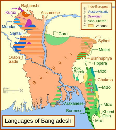
::贫困是司空见惯的;收入水平平均相当于每天几美元。 值得注意的是,文化仍然充满活力和活跃,追求各种机会或优势的生计。There are many ethnic groups in Bangladesh, and many languages are spoken. The official and most widely used language in Bangladesh is Bengali, which is an Indo-Aryan language of Sanskrit origin and has its own script. A Presidential Order in 1987 made Bengali the official language for the government of Bangladesh. Bengali is also the main language for the Indian state of West Bengal, which neighbors Bangladesh. English is used as the lingua franca among the middle and upper classes and in higher education. Many minor languages are spoken in Bangladesh and in the region as a whole.
::孟加拉国有许多族裔群体,并使用多种语言,孟加拉国官方和最广泛使用的语言是孟加拉语,孟加拉语是印度-亚利安语,原为梵语,有自己的文字;1987年的一项总统令将孟加拉语作为孟加拉国政府的官方语言;孟加拉语也是印度西孟加拉邦的主要语言,其邻国是孟加拉国;英语是中、上阶级和高等教育中使用的法语,孟加拉国和整个区域都使用许多次要语言。The official national language of Bangladesh is Modern Standard Bengali. It serves as the lingua franca of the nation, with 98 percent of Bangladeshis fluent in Bengali (including dialects) as their first language.
::孟加拉国的官方语言是现代标准孟加拉语,是国家的通用语言,98%的孟加拉国人以孟加拉语(包括方言)流利,作为第一语言。
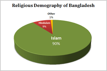
Most of the population, about 90 percent, is Muslim, with all but about three percent Sunni. There is a sizable minority, about 9 percent, which adheres to Hinduism, Buddhism, Christianity, or animism. The US State Department considers Bangladesh to be a moderate Islamic democratic country.
::大部分人口 — — 大约90% — — 都属于穆斯林,只有3%的逊尼派逊尼派逊尼派逊尼派逊尼派逊尼派逊尼派逊尼派逊尼派逊尼派逊尼派逊尼派逊尼派逊尼派逊尼派逊尼派逊尼派逊尼派逊尼派逊尼派逊尼派逊尼派逊尼派逊尼派逊尼派逊尼派。 大部分人口 — — 大约90% — — 都属于穆斯林,还有9%左右的少数派信奉印度教、佛教、基督教或反动主义。 美国国务院认为孟加拉国是一个温和的伊斯兰民主国家。Religions in Bangladesh
::孟加拉国的宗教
Bangladesh suffers from a demographic dilemma. Its tropical climate, availability of fresh water, and productive agricultural land have augmented a high population growth rate. The ever-increasing population is a growing concern. The government has stepped up its support for women’s health, birth control, and family planning services. This is an Islamic country, but practical approaches and common sense in regard to population control have won out over Islamic fundamentalism, which has not always supported family planning.
::孟加拉国面临着人口两难的困境。 其热带气候、淡水供应和生产性农业用地增加了高人口增长率。 人口不断增加越来越令人担忧。 政府加大了对妇女健康、节育和计划生育服务的支持力度。 这是一个伊斯兰国家,但是在人口控制方面的实用办法和常识已经赢得了伊斯兰原教旨主义的胜利,而伊斯兰原教旨主义并不总是支持计划生育。This poor and highly populated country has experienced political problems. Most of the people work in agriculture, while the remaining population is primarily concentrated in the service sector. Small business enterprises have been encouraged by the issuing of microcredit, or small loans, to assist people in using their skills to earn income.
::这个贫穷和人口稠密的国家经历了政治问题,大多数人务农,而其余人口主要集中在服务部门,小型商业企业因发放小额信贷或小额贷款来帮助人们利用技能赚取收入而受到鼓励。Globalization is evident in Bangladesh. As a result of the availability of cheap labor, sweatshops have been implemented to manufacture clothing for export to the world markets. The country also receives financial remittances from Bangladeshis working overseas in places such as the oil-rich region of the Middle East, which also is predominantly Muslim and is attracting cheap labor for its economic development projects funded by oil revenues.
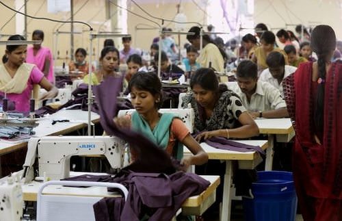
::全球化在孟加拉国是显而易见的。 由于廉价劳动力的可获性,血汗工厂已经用于制造向世界市场出口的服装。 孟加拉国还从在海外工作的孟加拉国人那里获得汇款,比如在中东石油丰富的地区,该地区也以穆斯林为主,为石油收入资助的经济发展项目吸引廉价劳动力。Sweatshop in Bangladesh
::孟加拉国的汗粉店
One example of how Bangladesh has been able to acquire materials such as steel is in the recycling of old ships. Shipping companies that have ships that are no longer viable for modern shipping have brought them to the shores of Bangladesh to be stripped down, taken apart, and the materials recycled.
::孟加拉国如何获得钢等材料的一个例子是老船的回收利用。 拥有不再适合现代航运的船舶的航运公司将这些船舶运到孟加拉国海岸被拆卸、拆卸和回收。Environmental Issues
::环境问题The summer monsoons are both a blessing and a curse in Bangladesh. The blessing of the monsoon rains is that they bring fresh water to grow food. The northeast part of Bangladesh receives the highest amount of rainfall, averaging about 18 feet per year, while the western part of the country averages only about four feet per year. Most of the rain falls during the monsoon season.
::夏季季风在孟加拉国既是福也是祸。 季风雨的祝福是它们带来新鲜水来种植粮食。 孟加拉国东北部降雨量最高,平均每年约18英尺,而该国西部每年平均只有约4英尺。 季风季节大部分降雨量都降于季风季节。Bangladesh can grow abundant food crops of rice and grain in the fertile deltas of the Ganges and Brahmaputra Rivers, rivers that ultimately empty into the Bay of Bengal. About 55 percent of the land area is arable and can be used for farming, but flooding causes serious damage to cropland by eroding soil and washing away seeds or crops.
::孟加拉可以在恒河和布拉马普特拉河的肥沃三角地带种植丰富的稻米和粮食作物,这些河流最终空入孟加拉湾。 大约55%的土地面积是可耕地,可用于耕种,但洪水侵蚀土壤,洗走种子或作物,对耕地造成严重损害。Every year, countless people die because of the flooding, which can cover as much as one-third of the country. One of the worst flooding events in Bangladesh’s history was experienced in 1998, when river flooding destroyed more than 300,000 homes and caused more than 1,000 deaths, rendering more than 30 million people homeless.
::每年有无数人死于洪水,洪水可以覆盖全国三分之一的人口。 孟加拉国历史上最严重的洪水事件之一是1998年发生的,当时河水洪水摧毁了300,000多座房屋,造成1,000多人死亡,3000多万人无家可归。Most parts of Bangladesh are fewer than 40 feet above sea level, and the country is vulnerable to major flooding according to various global warming scenarios. Half of the country could be flooded with a three-foot rise in sea level. Storm surges from cyclones killed as many as one 150,000 people in 1991. In comparison, about 2,000 people died when Hurricane Katrina hit New Orleans in 2006.
::孟加拉国大部分地区比海平面高出不到40英尺,而且根据各种全球变暖情况,该国易受重大洪灾的影响。该国一半地区可能因海平面上升三英尺而淹没。 1991年,飓风暴风雨造成多达150 000人死亡。 相比之下,2006年卡特里娜飓风袭击新奥尔良时,约有2 000人死亡。The high death toll from flooding does not receive its due attention from Western news media. Environmental concerns increase with the long-term projections of climate change. If sea level rises or if storms increase, then the low-lying agricultural lands of Bangladesh would suffer even more flooding and devastation. This would decrease the food supply of a growing population.
::洪水造成的高死亡人数没有得到西方新闻媒体应有的重视,环境关注随着气候变化的长期预测而增加。 如果海平面上升或风暴增加,孟加拉国低地农田将遭受更多的洪水和破坏,这将减少不断增长的人口的粮食供应。Another environmental problem for Bangladesh is deforestation. Wood is traditionally used for cooking and construction. The needs of a larger population have caused widespread deforestation. Brick and cement have become alternative building materials, and cow dung has become a widely used cooking fuel even though it reduces the fertilizer base for agriculture. Even so, these adaptations have not halted the deforestation problem. The main remaining forests are located along the southern borders with India and Burma and in the northeast sector.
::孟加拉国的另一个环境问题是砍伐森林,木材传统上用于烹饪和建筑,大量人口的需求导致大规模砍伐森林,砖块和水泥已成为替代建筑材料,牛粪虽然减少了农业肥料基础,但已成为广泛使用的烹饪燃料,即使如此,这些适应措施也未能制止毁林问题,剩下的主要森林位于与印度和缅甸接壤的南部边界和东北部。Bangladeshis suffer because of widespread water pollution from naturally occurring arsenic that contaminates water wells. The pyrite bedrock underneath much of western Bangladesh has large amounts of arsenic in it. Millions of people drink groundwater contaminated with this arsenic on a daily basis. Arsenic kills people slowly, by building up in their bodies, rotting their fingernails, giving them dark spots and bleeding sores. Arsenic is a slow killer and a carcinogen that increases the risk of skin cancer and tumors inside the body.
::孟加拉国人普遍遭受水污染,因为天然产生的砷污染污染了水井,孟加拉西部大部分地区的金石基岩中含有大量砷。 数百万人每天饮用受这种砷污染的地下水。 砷通过在身体中积聚,腐烂指甲,给他们带来黑暗的斑点和出血的疼痛,慢慢地杀人。 砷是一种缓慢的杀手,是一种致癌物,增加了体内皮肤癌和肿瘤的风险。Villagers in Bangladesh began being affected by these symptoms in the 1970s. In 1993, official tests indicated that up to 95 percent of the wells in one of the villages in the western region were contaminated. The widespread water contamination has also had a social cost. Reports indicate that husbands are sending their disfigured wives back to their families of origin, and some young people are remaining single. Stories are told of people who believe that health problems are contagious or genetic and can be passed on to children.
::1970年代,孟加拉国的村民开始受到这些症状的影响。1993年,官方测试表明,西部地区一个村庄95%的水井受到污染,水污染普遍也造成了社会代价。报告显示,丈夫们把他们的破损妻子送回原居家庭,有些年轻人仍然单身。人们相信,健康问题是传染性的或遗传性的,可以传给子女。
Key Takeaways
::密钥外出-
When Britain’s colonialism ended in South Asia in 1947, the Muslim League was instrumental in creating the united Muslim state with both East Pakistan and West Pakistan under one government. East Pakistan broke away and became the independent country of Bangladesh in 1972.
::当1947年英国的殖民主义在南亚结束时,穆斯林联盟在建立一个以东巴基斯坦和西巴基斯坦为首的联合穆斯林国家方面起了重要作用。 东巴基斯坦解体后,1972年成为孟加拉国的独立国家。
::当1947年英国的殖民主义在南亚结束时,穆斯林联盟在建立一个以东巴基斯坦和西巴基斯坦为首的联合穆斯林国家方面起了重要作用。 东巴基斯坦解体后,1972年成为孟加拉国的独立国家。 -
Both Pakistan and Bangladesh have large populations that are increasing rapidly. Both countries have agriculturally based economies. Rural-to-urban shift is occurring at an ever-increasing rate in both countries. Population growth places a heavy tax on natural resources and social services.
::巴基斯坦和孟加拉国人口众多,正在迅速增长,两国都拥有以农业为基础的经济,两国的农村向城市的转变正在以不断增长的速度发生,人口增长对自然资源和社会服务课以重税。
::巴基斯坦和孟加拉国人口众多,正在迅速增长,两国都拥有以农业为基础的经济,两国的农村向城市的转变正在以不断增长的速度发生,人口增长对自然资源和社会服务课以重税。 -
The political units within Pakistan include four main provinces. Tribal Areas border Afghanistan and are controlled by local leaders. The Northern Areas are disputed with India. Each of the provinces has its own unique physical and human landscapes.
::巴基斯坦的政治单位包括四个主要省份,部落地区与阿富汗接壤,由地方领导人控制,北部地区与印度有争议,每个省份都有独特的自然和人文景观。
::巴基斯坦的政治单位包括四个主要省份,部落地区与阿富汗接壤,由地方领导人控制,北部地区与印度有争议,每个省份都有独特的自然和人文景观。 -
Earthquakes are common in Pakistan because the country is located on a tectonic plate boundary. Deforestation and water pollution are two other major environmental concerns.
::地震在巴基斯坦很常见,因为巴基斯坦位于构造板块边界上,砍伐森林和水污染是另外两个主要环境问题。
::地震在巴基斯坦很常见,因为巴基斯坦位于构造板块边界上,砍伐森林和水污染是另外两个主要环境问题。 -
Bangladesh is a low-lying country with the Brahmaputra River, Ganges River, and the Meghna River flowing into the Bay of Bengal. Flooding is a major environmental concern that has devastated the country on a regular basis.
::孟加拉国是一个低洼国家,布拉马普特拉河、恒河和梅格纳河流入孟加拉湾。 洪水是一个重大的环境问题,经常给孟加拉国造成破坏。
::孟加拉国是一个低洼国家,布拉马普特拉河、恒河和梅格纳河流入孟加拉湾。 洪水是一个重大的环境问题,经常给孟加拉国造成破坏。
Vocabulary Terms
::词汇术语术语Chapter 9.3 Pakistan and Bangladesh
::第9.3章 巴基斯坦和孟加拉国cyclone
::气旋intense tropical storm system with high winds and heavy rains
::暴风和暴雨高的热带强热带风暴系统Indus River
::印地河major river system found in Pakistan
::巴基斯坦发现的主要河流系统Islam
::伊斯兰伊斯兰伊斯兰伊斯兰伊斯兰religion observed by most people in Pakistan and Bangladesh
::巴基斯坦和孟加拉国多数人信奉的宗教Khyber Pass
::Khyber 通行证for centuries, the pass used by people traveling through South Asia from the north
::几个世纪以来,人们从北边穿过南亚旅行的通行证partition
::分区分区T he se paration ; division into two or more territorial units having separate political status
::分离;分为两个或两个以上具有单独政治地位的领土单位Urdu
::乌尔都official language of Pakistan
::巴基斯坦官方语言 巴基斯坦官方语言Applying Knowledge
::应用知识Discussion and Study Questions
::讨论和研究问题-
What happened to East Pakistan? Why did its name change?
::东巴基斯坦怎么了 为什么改名? -
Why does Pakistan have a forward capital? Where is it? Where did the capital used to be?
::巴基斯坦为何有前期资本?资本在哪里?资本过去在哪里? -
Compare the population density of Pakistan, Bangladesh, and the United States.
::比较巴基斯坦、孟加拉国和美国的人口密度。 -
What are the four main provinces of Pakistan? How are they different from each other?
::巴基斯坦的四个主要省份是什么?它们之间有什么不同? -
How is Bangladesh affected by the summer monsoon? How much rain can it receive annually?
::孟加拉如何受夏季季风影响? -
What are the main environmental problems in Pakistan? In Bangladesh?
::巴基斯坦的主要环境问题是什么?孟加拉国的主要环境问题是什么? -
What type of government does Pakistan have? What is the law based on?
::巴基斯坦有什么样的政府?法律基于什么? -
How could both countries address their population growth situation?
::两国如何应对其人口增长状况? -
Who was the first woman prime minister of Pakistan? What happened to her?
::巴基斯坦第一位女总理是谁? -
How has microcredit aided in the economic development of Bangladesh?
::小额信贷如何帮助孟加拉国的经济发展?
Real-World Geography Exercise
::现实世界地理演习-
Using
, complete the following activities:
-
Locate each place on the bulleted list below.
::在下面的子弹名单上 找到每个地方 -
Find the nearest city with an international airport in proximity to each location on the bulleted list below.
::找到最近的城市,在下面子弹清单上每个地点附近有一个国际机场。 -
Calculate the distance and travel time by plane to each city from the
in Orlando, Florida.
::计算从佛罗里达州奥兰多到每个城市的飞机距离和旅行时间。
::使用,完成以下活动: 确定以下子弹清单上的每个地点; 找到最近的城市, 在下面子弹清单上的每个地点附近有一个国际机场。 计算从佛罗里达州奥兰多到每个城市的距离和飞行时间。 -
Locate each place on the bulleted list below.
-
Using
, determine the latitude and longitude for each location on the bulleted list below.
::使用,确定以下子弹列表中每个位置的纬度和经度。 -
Be prepared to share and discuss your answers.
::准备分享和讨论你的答案
-
Arabian Sea
::阿拉伯海 -
Azad Kashmir
::阿扎德克什米尔 -
Baluchistan
::俾路支 -
Bay of Bengal
::孟加拉湾 -
Brahmaputra River
::布拉马普特拉河 -
Ganges River
::恒河河 -
Gilgit-Baltistan
::吉尔吉特-巴尔蒂斯坦 -
Hyderabad
::海得拉巴 -
Indus River
::印地河 -
Karachi
::卡拉奇 -
Khyber Pakhtunkhwa
::开伯尔-普赫图赫瓦 -
Khyber Pass
::Khyber 通行证 -
Lahore
::拉合尔 -
Meghna River
::Meghna河 -
Northern Areas
::北部地区 -
Punjab
::旁遮普 -
Sindh
::信德省 -
Thar Desert
::塔尔沙漠
Current Events
::当前事件Videos for Geography Enrichment
::地理丰富视频Helpful Websites for the Study of Geography
::地理研究有用网站is an encyclopedia funded by the Canadian government covering all branches of knowledge. Their scholarly collection includes interactive materials.
::该百科全书由加拿大政府资助,涵盖所有知识分支,其学术收藏包括交互式材料。provides information on the people, history, government, economy, energy, geography, communications, transportation, military, and transnational issues for the world's entities.
::向世界各实体提供关于人民、历史、政府、经济、能源、地理、通信、运输、军事和跨国问题的资料。is a US government website where you can find federal legislation, past and present, as well as information about the US legal system.
::是一个美国政府的网站,您可以在此找到过去和现在的联邦立法以及关于美国法律制度的信息。is a government agency website that provides current news, resources, topics of interest, information about drugs, careers in the DEA, and a tip hotline.
::是一个政府机构网站,提供最新消息、资源、感兴趣的话题、毒品信息、在缉毒局的职业以及一条小费热线。is the largest library in the world and provides manuscripts, files, information, pictures, and videos.
::图书馆是世界上最大的图书馆,提供手稿、文件、信息、图片和录像。is a US government agency website that allows users to search for and retrieve satellite images of Earth.
::这是一个美国政府机构的网站,用户可以搜索和检索地球的卫星图像。is a US government website that provides historical documents, photos, records, publications, and educator resources.
::这是一个美国政府网站,提供历史文件、照片、记录、出版物和教育资源。is a US government agency website that provides weather-related information and ocean research.
::是一个提供气象信息和海洋研究的美国政府机构网站。is a website by the United States Geological Survey and other federal, state, and local agencies that delivers topographic information for the United States.
::这是美国地质调查局和其他联邦、州和地方机构为美国提供地形信息的网站。is a massive central data source and a handy way to graphically compare nations.
::是一个庞大的中央数据源,是用图形比较国家的一种方便方式。is a website that measures most locations in the world for air pollution in real time.
::是一个实时测量世界上大多数空气污染地点的网站。is a unique statistical database, which allows you to research and compare a multitude of different data on US states.
::这是一个独特的统计数据库, 使你能够研究和比较关于美国各州的多种不同数据。is an international organization founded in 1945 and made up of 193 member states. The UN maintains international peace and security, protects human rights, delivers humanitarian aid, promotes sustainable development, and upholds international law.
::联合国是一个国际组织,成立于1945年,由193个成员国组成。 联合国维护国际和平与安全,保护人权,提供人道主义援助,促进可持续发展,维护国际法。is a US government agency that provides a population clock, data, surveys, statistics, a library with information and infographics, news about the economy, and much more.
::这是一个美国政府机构,它提供人口钟、数据、调查、统计、一个拥有信息和信息资料的图书馆、关于经济的新闻,以及更多。is a US government agency website that provides scientific information about the natural hazards that threaten lives, the natural resources we rely on, the health of our ecosystems and environment, and the impacts of climate and land-use change.
::这是一个美国政府机构的网站,提供科学信息,说明威胁生命的自然危害、我们赖以生存的自然资源、生态系统和环境的健康以及气候和土地使用变化的影响。is a US government website that provides the latest presidential news, information about the budget, policy, defense, and many more topics.
::提供最新总统新闻、预算、政策、国防等资讯, 以及更多议题。is under the United Nations and provides leadership on matters critical to health, shapes the research agenda on health, and monitors the health situation and assessing health trends around the world. Their website provides information on the state of health around the world, outbreaks, current health news, and more.
::网站提供世界各地卫生状况、疫情爆发、最新卫生新闻等信息。is an intergovernmental organization that regulates international trade. The website provides information on the history of the multilateral trading system, featured videos, news and events, trade topics, and more.
::该网站提供关于多边贸易体系历史的信息、视频、新闻和事件、贸易专题等等。 -
Outline how Pakistan and Bangladesh are similar in their populations and economic dynamics but different in their physical environments.
")