11.5 南极(2天)
章节大纲
-
Chapter Challenges
::章次 挑战-
Describe the layout of the continent’s main physical features, including the ice shelves and volcanic activity.
::描述非洲大陆主要物理特征的布局,包括冰架和火山活动。 -
List the political nature of the various claims held on sections of Antarctica and explain how the continent is managed by the international community.
::列出对南极洲部分地区的各种主张的政治性质,并解释国际社会如何管理该大陆。 -
Summarize the dynamics of the principle of global warming and describe what changes would occur in Antarctica and the rest of the world if the ice sheet covering Antarctica were to melt.
::概述全球变暖原则的动态,并描述如果覆盖南极洲的冰盖融化,南极洲和世界其他地区将发生哪些变化。 -
Describe how good ozone is depleted and explain the role Antarctica plays in the seasonal cycle of changes in the amount of ozone in the atmosphere above the South Pole.
::说明臭氧消耗情况如何良好,并解释南极洲在南极上空大气臭氧量变化的季节性循环中所起的作用。
Student Learning Objectives
::学生学习目标TEKS Regional Unit 11 Oceania: Chapter 11.5 Antarctica
::TEKS 11区域股 大洋洲:11.5章南极洲WG,3A Explain weather conditions and climate in relation to annual changes in Earth-Sun relationships.
::工作组,3A 结合地球-太阳关系的年度变化解释天气条件和气候。WG.4A Explain how elevation, latitude, wind systems, ocean currents, position on a continent, and mountain barriers influence temperature, precipitation, and distribution of climate regions.
::WG.4A 解释高海拔、纬度、风力系统、洋流、大陆位置、山地屏障如何影响气候区域的温度、降水量和分布。WG.4B Describe different landforms and the physical processes that cause their development.
::WG.4B 描述不同的土地形态和导致其发展的物理过程。WG.4C Explain the influence of climate on the distribution of biomes in different regions.
::WG.4C 解释气候对不同区域生物群落分布的影响。WG.14C Analyze the human and physical factors that influence the power to control territory and resources.
::WG.14C 分析影响控制领土和资源的权力的人的因素和物质因素。WG.19A Evaluate the significance of major technological innovations in the areas of transportation and energy that have been used to modify the physical environment.
::WG.19A 评价用于改变自然环境的运输和能源领域重大技术革新的重要性。WG.19C Examine the environmental, economic, and social impacts of advances in technology on agriculture and natural resources.
::WG.19C 审查技术进步对环境、经济和社会对农业和自然资源的影响。WG.21A Analyze and evaluate the validity and utility of multiple sources of geographic information such as primary and secondary sources, aerial photographs, and maps.
::WG.21A 分析和评价多种地理资料来源,例如主要和次要资料来源、航空照片和地图的有效性和效用。WG.21B Locate places of contemporary geopolitical significance on a map.
::WG.21B 在地图上标出具有当代地缘政治意义的地点。WG.21C Create and interpret different types of maps to answer geographic questions, infer relationships, and analyze change.
::WG.21C 创建和解释不同类型的地图,以回答地理问题、推断关系和分析变化。WG.22A Design and draw appropriate graphics such as maps, diagrams, tables, and graphs to communicate geographic features, distributions, and relationships. features, distributions, and relationships.
::WG.22A 设计和绘制适当的图形,如地图、图表、表格和图表,以交流地理特征、分布和关系、特征、分布和关系。WG.22C Use geographic terminology correctly.
::WG.22C 正确使用地理术语。WG.22D Use standard grammar, spelling, sentence structure, and punctuation.
::WG.22D 使用标准语法、拼写、句子结构和标点。WG.22E Create original work using proper citations and understanding and avoiding plagiarism
::WG.22E 利用适当的引文和理解并避免损害,创建原始工作Antarctica
::南极洲Antarctica is Earth's southernmost continent. It contains the geographic South Pole and is situated in the Antarctic region of the Southern Hemisphere, almost entirely south of the Antarctic Circle, and is surrounded by the Southern Ocean.
::南极洲是地球最南端的大陆,包括地理上的南极,位于南半球的南极区域,几乎完全位于南极圈以南,周围环绕着南大洋。The Southern Ocean
::南大洋The Southern Ocean, which surrounds the continent of Antarctica, is often misunderstood or not included on many maps of the Southern Hemisphere. The cold waters off the coast of Antarctica move from west to east in a clockwise rotation around the continent in a movement called the West Wind Drift, or the Antarctic Circumpolar Current.
::环绕南极洲大陆的南大洋常常被误解或未列入南半球的许多地图。 南极洲海岸的寒冷水域在大陆周围顺时针旋转,在西风流或南极环流运动中从西向东移动。The Southern Ocean’s northern boundary does not border a land mass but meets up with the Atlantic, Pacific, and Indian Oceans. Most geographers accept the northern boundary of the Southern Ocean to be located south of 60° latitude even though the actual limit has not yet been firmly agreed upon.
::南大洋的北部边界并不与陆地相邻,而是与大西洋、太平洋和印度洋相交。 大多数地理学家接受南大洋北部边界位于南纬60度以南,尽管实际界限尚未达成明确协议。The Southern Ocean’s northern boundary has more to do with the marine conditions of the realm. There is a transition called the Subtropical Convergence in which the cold, dense waters of the Southern Ocean meet up with the warmer waters of the Pacific, Atlantic, and Indian Oceans. The cold, dense water from the south sinks below the warm waters from the north to create a zone of upwelling and mixing that is conducive to high levels of productivity for organisms such as phytoplankton and krill.
::南大洋的北部边界更多地与南大洋的海洋条件有关。 南大洋的北部边界与南大洋的海洋条件有关。 南大洋的冷密水域与太平洋、大西洋和印度洋较温暖的水域交汇而来,出现了被称为亚热带汇合的过渡。 南大洋的冷密水域与太平洋、大西洋和印度洋较温暖的水域相交。 北大洋温暖水域下方的冷密密的南方汇水层形成一个有利于浮游植物和磷虾等生物高生产力的上升和混合区。The zone of Subtropical Convergence can be visually observed by the grayish, cold southern waters meeting up with the bluish-green, warm northern waters. The krill, which thrive on phytoplankton, are an important link in the food chain for marine organism such as fish, penguins, seals, albatrosses, and whales in the Southern Ocean.
::亚热带汇合区可见于灰色、寒冷的南方水域,它们与白绿色、温暖的北方水域相交。 磷虾在浮游植物上繁衍,是南大洋鱼类、企鹅、海豹、信天翁和鲸鱼等海洋生物食物链的重要环节。Physical Geography
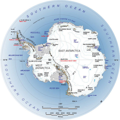
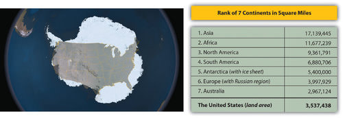
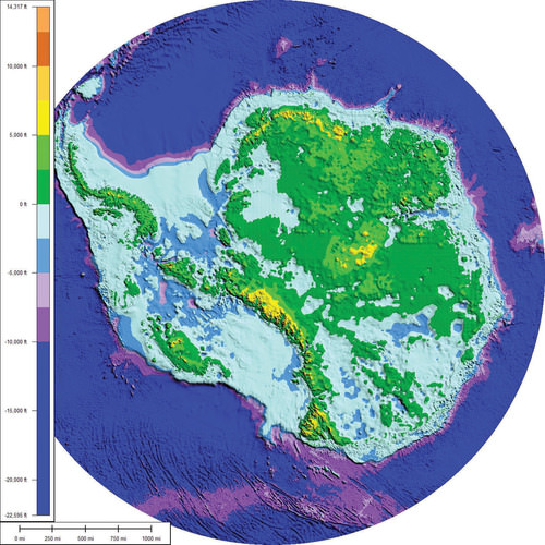
::物理地理The world has seven focal continents. Rated by physical area from the largest to the smallest, they are Asia, Africa, North America, South America, Antarctica, Australia, and Europe. Antarctica, which is larger than Australia and 1.3 times larger than Europe, is located entirely south of 60° latitude and is surrounded by the Southern Ocean. Antarctica has the highest average elevation of any continent; there are many mountain ranges. The 2,000-mile-long Trans-Antarctic Mountain range divides Antarctica into a small western region and a larger eastern region.
::南极洲面积比澳大利亚大,比欧洲大1.3倍,位于整个纬度60°以南,环绕南大洋,南极洲是任何大陆平均海拔最高的地区,有许多山脉,2000英里长的跨南极山脉将南极洲分为一个较小的西部地区和一个较大的东部地区。At both ends of the Trans-Antarctic Mountains are the two main ice shelves: the Ross Ice Shelf and the Ronne Ice Shelf. The Ellsworth Mountains are located in the western region and are home to Mount Vinson (or the Vinson Massif), which is the highest peak on the continent, reaching an elevation of 16,050 feet. This is higher than any mountain in the contiguous, continental United States, Europe, or Australia.
::横贯南极山脉两端是两个主要的冰架:罗斯冰架和罗恩冰架,埃尔斯沃斯山脉位于西部地区,是本大陆最高山峰文森山(或文森马西夫山)的所在地,达到16 050英尺的海拔,高于毗连、美国大陆、欧洲或澳大利亚的任何山峰。Antarctica without the ice sheet would be considerably smaller; some estimate it would be only about 100,000 square miles in land area, or the equivalent of the physical area of the US state of Colorado.
::没有冰盖的南极洲将大大缩小;一些人估计,在陆地面积中,南极洲大约只有100 000平方英里,或相当于美国科罗拉多州的实际面积。
The Antarctic Peninsula is actually an extension of the Andes Mountains of South America and is home to active volcanoes. The peninsula is the location of a volcano on Deception Island that erupted in the late 1960s and destroyed research stations in the area. There was an additional large eruption in 1970. The volcano continues to show activity, and sightings of lava flow continue to be reported.
::南极半岛实际上是南美洲安第斯山脉的延伸,是活火山的栖息地,该半岛是1960年代后期在霸权岛爆发的火山所在地,并摧毁了该地区的研究站,1970年又爆发了一次大型火山爆发,火山继续活动,继续有看到熔岩流的报道。There may be more volcanic activity than what has been recorded. An underwater volcano in the Antarctic Peninsula was discovered in 2004. Mount Erebus (12,448 feet), located on Ross Island on the other side of Antarctica from the Antarctic Peninsula, is the world’s southernmost active volcano. Mount Erebus has been active since 1972 and has a large lava lake in its inner crater.
::火山活动可能比记录中的火山活动要多。 2004年在南极半岛发现了一座水下火山。 埃雷布斯山(12,448英尺)位于南极半岛南极洲另一边罗斯岛,位于南极半岛,是世界上最南端活跃的火山。 埃雷布斯山自1972年以来一直活跃,在其内部火山口有一个巨大的熔岩湖。About 98 percent of Antarctica is covered by an ice sheet that is, on average, up to a mile deep. In some areas, it is nearly three miles deep. In the winter season, the ice sheet’s area might double as it extends out from the coastline. The Antarctic ice sheet holds about 70 percent of the earth’s fresh water. If the ice sheet were to melt, the sea level could rise considerably and cover many of the earth’s low-lying islands, peninsulas, and coastal regions with low elevations.
::南极洲大约98%的冰盖覆盖了南极洲。 冰盖平均高达1英里深。 在一些地区,冰盖深度近3英里。 在冬季,冰盖面积可能翻倍,因为它从海岸线延伸而来。 南极冰盖约占地球淡水的70%。 如果冰盖融化,海平面可能会大幅上升,覆盖地势低洼的许多岛屿、半岛和沿海地区。Antarctica is considered a desert because it usually averages fewer than 10 inches of precipitation per year. Coastal regions annually receive as much as four feet of snow, while the interior near the South Pole might only receive a few inches.
::南极洲被认为是沙漠,因为通常每年平均降水量不到10英寸,沿海地区每年降雪多达4英尺,而南极附近的内地可能只得到几英寸。Glaciers and rock outcrops in Marie Byrd Land seen from NASA's DC-8 aircraft.
::从美国航天局的DC-8飞机上看到Marie Byrd Land的冰川和岩石裂缝。
There are areas in Antarctica that are not covered with ice but have a landscape of bare ground. This nonice portion of the continent protrudes above the ice sheet and only covers a combined physical area equivalent to about half the US state of Kentucky. The only plant life that exists here are the many different mosses and lichens that grow during short periods of the year.
::南极洲有些地区没有冰层覆盖,但有一片裸露的地貌。 大陆的这一非非部分在冰原上方,只覆盖相当于美国肯塔基州一半左右的综合物理面积。 这里唯一的植物寿命是每年短时期内生长的多种不同的苔稼和地衣。Below the giant ice sheet are dozens of sub-glacial lakes. Lake Vostok, the largest lake discovered in the Antarctic so far, was found two miles below the ice sheet and is the size of Lake Ontario. It is unknown what aquatic life might exist in these lakes. If all the ice and snow were removed from the continent, the total land area would be considerably smaller and would consist mainly of mountain ranges and islands.
::在巨大的冰层下方有数十个冰川以下湖泊。至今在南极洲发现的最大湖泊沃斯托克湖(Vostok湖)位于冰层下方两英里处,是安大略湖的大小,不清楚这些湖泊中可能存在哪些水生生物。如果将所有冰雪从大陆移走,陆地总面积将大大缩小,主要包括山脉和岛屿。Some estimate that this land area altogether would only equate to about 100,000 square miles, roughly equivalent to the physical area of the US state of Colorado. This does not account for the fact that if all the ice were to melt, the sea level would rise and cover more land area. The land portion of the continent would also expand upward because of the loss of the weight of the ice, which has been compressing the continent.
::有些人估计这片陆地面积总共只相当于约100,000平方英里,大致相当于美国科罗拉多州的实际面积。 这并不能说明如果所有冰层融化,海平面就会上升并覆盖更多的陆地面积。 非洲大陆的陆地部分也会因为冰块重量的丧失而向上扩张,冰块的重量一直在压缩着整个大陆。Not only is Antarctica the driest continent with the least average annual precipitation and the highest continent in average elevation; it is also the coldest of the continents. The lowest temperature ever recorded on Earth was −128 °F in 1983 at a Russian research station in Antarctica. Temperatures reach a minimum of less than −110 °F in winter in the interior and greater than 55 °F near the coast in summer. No permanent human settlements exist in Antarctica other than research stations from a number of countries.
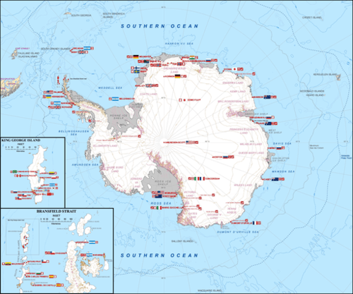
::南极洲不仅是年平均降水量最少和平均海拔最高的大陆,也是大陆中最寒冷的大陆,1983年,在俄罗斯南极洲的一个研究站,地球上记录的最低气温为-128摄氏度,内地冬季温度至少不到-110摄氏度,夏季离海岸不到55摄氏度,南极洲除了一些国家的研究站外,没有永久性人类住区。This map shows the location of permanent Antarctic research stations.
::该地图显示南极永久研究站的位置。The Antarctic Treaty
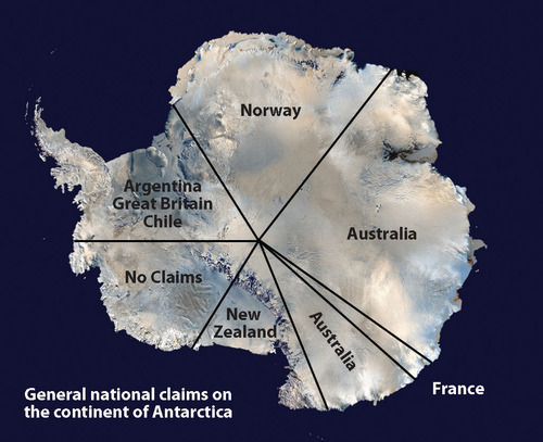
::《南极条约》The continent is not politically controlled by any one government. Early seafaring explorers sailed in these waters, and various countries laid claim to sections of the continent. The continent was first sighted by explorers in 1820, and the South Pole was first reached in 1911. Land claims to the continent were established by the home countries of early explorers.
::非洲大陆在政治上不受任何一国政府控制。 早期航海探险家在这些水域航行,各国向大陆部分地区提出权利主张。 1820年,探险家首次发现该大陆,1911年,南极首次达到。 早期探险家的母国确定了对大陆的土地主张。Forty-six countries are now included in the , which was originally signed by 12 countries in 1959. The treaty, designed to protect the environment and encourage scientific research, prohibits military activities, mineral mining, and the disposal of waste products. All land claims were suspended when the Antarctic Treaty was initiated, but the claims are not without political consequences.
::该条约旨在保护环境和鼓励科学研究,禁止军事活动、矿产开采和废物处理,在《南极条约》启动时,所有土地要求都中止,但要求并非没有政治后果。Antarctica is divided into pie-shaped sections, and each of the original claimant countries is allocated a portion, according to their claim. The countries with original claims are Norway, New Zealand, France, Chile, Australia, and Argentina. Other countries, including Brazil, Peru, Russia, South Africa, Spain, and the United States, have reserved their right to submit claims on the continent in the future if the issue of territorial claims becomes significant. A large sector of West Antarctica called Marie Byrd Land remains unclaimed.
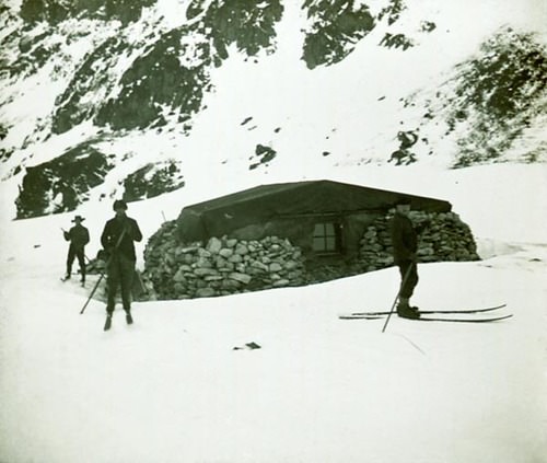
::南极洲分为派形部分,每个原始索赔国根据其索赔要求分出一部分,有原始索赔要求的国家是挪威、新西兰、法国、智利、澳大利亚和阿根廷,其他国家,包括巴西、秘鲁、俄罗斯、南非、西班牙和美国,如果领土要求问题变得重要,保留今后在该大陆提出索赔要求的权利,称为Marie Byrd Land的西南极洲大片地区仍然无人认领。Research stations account for the entire human population in Antarctica. Approximately 1,000 people live in Antarctica year-round, and up to 5,000 or more live there during the summer months. Many of the research stations rotate their personnel, and tours of duty last anywhere from a few months to a year or more. Various family groups have worked there as well as other service workers, including Russian Orthodox priests, who have rotated every year at one of the Russian research stations.
::南极洲有大约1,000人全年居住在南极洲,夏季有5,000人或更多人生活在南极洲,许多研究站轮换工作人员,工作期限从几个月到一年或一年以上不等,各种家庭团体在那里工作,其他服务人员,包括每年在俄罗斯一个研究站轮换的俄罗斯东正教牧师。The Omond House was the first permanent base built in 1903 by the Scottish National Antarctic Expedition.
::Omond House是1903年苏格兰国家南极探险队建造的第一个永久性基地。
Tourism brings the largest number of additional people to the continent. Tourists come for short-term visits to experience the conditions or see the many species of penguins or fauna that exist here. More than 45,000 tourists visit the Antarctic Treaty area yearly. Most arrive on commercial ships that specialize in tours of the region. Tours only last one or two weeks.
::旅游业使更多的人来到非洲大陆的人数最多,游客来此进行短期访问,以体验这里存在的许多企鹅或动物物种的状况或参观这些物种,每年有45 000多名游客访问南极条约区,大多数抵达的商业船只专门从事该区域的旅游,旅游仅持续一两个星期。The National Geographic Explorer in fast ice, Antarctica.
::南极洲快冰区国家地理探索者
Research has revealed that mineral resources are to be found under the ice in Antarctica, and oil and natural gas are found in offshore deposits. Antarctica is a frontier for economic development that is not under the jurisdiction of any one government. The Antarctic Treaty has been the determinant of the level of human activity. The current treaty restricts any extractive activity.
::研究显示,南极洲的冰层下有矿物资源,近海矿床有石油和天然气,南极洲是经济发展的前沿,不属于任何一个政府管辖,《南极条约》是人类活动水平的决定因素,目前的条约限制任何开采活动。Fishing is also regulated within the treaty, but without enforcement procedures, there have been questions about its effectiveness. Whaling was once a major industry in this realm. Whaling stations were established on the Antarctic Peninsula and nearby South Georgia Island. However, the increased use and extraction of petroleum reduced the need for whale oil and the industry collapsed.
::渔业也受条约管制,但没有执行程序,就对其有效性提出了问题,捕鲸曾经是这一领域的一个主要行业,南极半岛和附近的南乔治亚岛建立了捕鲸站,但石油的使用和开采的增加减少了对鲸油的需求,该行业崩溃了。Some whaling continues in the waters of the Southern Ocean, which has led to questions about how to manage these natural resources. In 1998, negotiations between interested countries met in Madrid, Spain, and created the Protocol on Environmental Protection to the Antarctic Treaty (known as the Madrid Protocol). The protocol designates Antarctica as a natural reserve that can only be used for peaceful purposes and for science. All mining or economic activity is banned.
::1998年,有关国家在西班牙马德里举行谈判,并制定了《南极条约环境保护议定书》(又称《马德里议定书》),该议定书指定南极洲为自然保护区,只能用于和平目的和科学,禁止一切采矿或经济活动。Climate Change
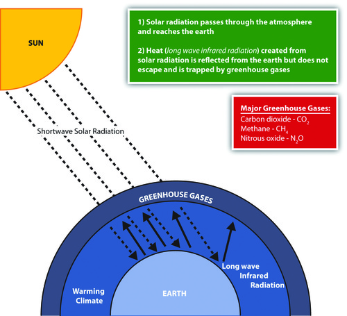
::气候变化气候变化This graphic illustrates the greenhouse effect and climate change.
::这个图示说明了温室效应和气候变化。
Climate changes on Earth have varied widely during the planet’s history. There have been long periods of heating or cooling. The last ice age, which ended about 10,000 years ago, created large ice sheets that covered much of the Northern Hemisphere. The earth then entered into the current inter-glacial period with warmer temperatures that melted the ice sheets.
::地球的气候变化在地球历史上差异很大。 长期的暖气或冷却已经存在。 上一个冰河时代(大约在一万年前结束 ) , 创造了覆盖北半球大部分地区的大冰盖。 然后,地球进入了当前的冰雪间时期,温度升高,冰盖融化了。The polar regions have the last remaining ice on the planet. The earth has experienced large fluctuations in its temperature at various times in its past. Natural changes in the conditions that affect climate can include but are not limited to the dynamics of the sun, changes in the earth’s orbit, and volcanic eruptions.
::极地地区有地球上最后剩下的冰块。 过去,地球的温度在不同的时间经历了巨大的波动。 影响气候的条件的自然变化可以包括但不限于太阳的动态、地球轨道的变化和火山爆发。Human activity has impacted conditions both locally and globally. Since the Industrial Revolution, humans have been pumping enormous amounts of carbon dioxide into the atmosphere, which affects the planet’s climate and temperature. The Industrial Revolution introduced the burning of coal as a fuel to boil water to operate steam engines. This allowed power to become more versatile and mobile. The introduction of the automobile increased the burning of petroleum, which released carbon dioxide into the atmosphere in the form of engine exhaust.
::自工业革命以来,人类一直在将大量的二氧化碳注入大气,这影响了地球的气候和温度。 工业革命将煤炭作为燃水燃料引入蒸汽机操作。 这使得电力能够更灵活、更机动。 汽车的引入增加了石油燃烧,以发动机排气的形式将二氧化碳释放到大气中。Large-scale deforestation and the burning of fossil fuels have increased the quantity of heat-trapping “greenhouse gases” in the atmosphere. Nitrous oxide, methane, carbon dioxide, and similar gases act like the glass panels of a greenhouse that allow short-wave radiation from the sun to enter but do not allow the long-wave radiation of heat to escape into space.
::大规模砍伐森林和燃烧化石燃料增加了大气中热源“温室气体”的数量。 氧化氮、甲烷、二氧化碳和类似气体就像温室的玻璃板,允许太阳短波辐射进入,但不允许长波热辐射进入太空。Deforestation reduces the number of trees that use carbon dioxide and store carbon in plant fibers. The burning of wood or carbon-based energy sources such as oil or coal releases the carbon back into the atmosphere. Fossil fuels are created when dead plant and animal life have been under pressure and decay for long periods and have retained their carbon component. This all leads to a rise in the activity of the carbon cycle. Carbon is a key component to the regulation of the earth’s temperature. Life on Earth is dependent on temperature conditions that are regulated by the atmosphere. This natural cycle has been changed by human activity.
::砍伐森林减少了使用二氧化碳并将碳储存在植物纤维中的树木数量。燃烧木材或石油或煤炭等碳源或碳基能源将碳释放回大气层。当植物和动物死亡生命长期遭受压力和腐烂并保留其碳成分时,化石燃料就会产生。所有这些都导致碳循环活动增加。碳是调节地球温度的一个关键组成部分。地球上的生命取决于大气调节的温度条件。人类活动改变了这一自然循环。Changing global temperatures is one aspect of climate change that has received attention in recent years. Global warming is an average increase in the temperature of the atmosphere near the earth’s surface. Few environmental effects could impact Antarctica as much as the phenomenon of changing temperatures. There would be serious consequences for the entire world if temperatures would increase to the extent that the Antarctic ice sheet would melt and dissolve away.
::全球气温变化是近年来引起人们关注的气候变化的一个方面。 全球变暖是地球表面附近大气温度平均上升的一个方面。 影响南极洲的环境影响与温度变化一样少。 如果气温升高到南极冰盖融化和溶解的程度,则会对整个世界造成严重后果。Sea levels would rise, and many areas of the planet with large urban populations would be flooded. For instance, many of the largest urban centers in the world are port cities that rely on the import and export of goods and materials. These cities would be in danger of being under water if the sea level were to rise even a few feet, let alone up to 200 feet (approximated to be equivalent to the volume of water in the polar ice caps).
::海平面会升高,而地球上许多城市人口众多的地区将会被淹没。 比如,世界上许多最大的城市中心都是依赖货物和材料进出口的港口城市。 如果海平面上升甚至几英尺,更不用说200英尺(大概相当于极地冰盖的水量 ) , 这些城市将面临水下的危险。Light-colored surfaces such as snow and ice reflect more radiation than do darker surfaces. If the Antarctic ice sheet were to melt, this would certainly worsen global climate change, as more radiation would be absorbed at the surface (land and water).
::雪和冰等浅色表面反映的辐射比更暗的表面要多。 如果南极冰盖融化,这肯定会加剧全球气候变化,因为更多的辐射将在表面(陆地和水)吸收。Climate change might also affect agricultural production. Global changes in temperature would alter ecosystems and the habitats of organisms, changing the balance of nature in many biomes. The scientific community continues to study the dynamics of climate change. In the last decade, some of the warmest annual temperatures in the past century have been documented.
::气候变化还可能影响农业生产,全球温度变化将改变生态系统和生物栖息地,改变许多生物群落的自然平衡,科学界继续研究气候变化的动态,过去十年来,记录了上个世纪一些最温暖的年度温度。Data gathered from both the National Oceanic and Atmospheric Administration (NOAA) and the National Aeronautics and Space Administration (NASA) indicate that the earth’s surface temperatures have increased by more than one degree in the past 100 years.
::从国家海洋和大气管理局(诺阿)和国家航空和航天局(美国航天局)收集的数据表明,地球表面温度在过去100年中上升了1倍以上。Ozone Depletion
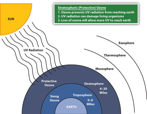
::臭氧消耗Climate change can have a major impact on atmospheric conditions. Good ozone depletion in the stratosphere (the second layer of the earth’s atmosphere) has different causes and conditions than temperature change in the troposphere (the layer just above the earth’s surface). The two concepts have separate and distinct dynamics that are not directly related. Ozone (O 3 ) is a simple molecule consisting of three oxygen atoms. Common oxygen gas molecules have two oxygen atoms (O 2 ).
::气候变化可以对大气条件产生重大影响。平流层(地球大气的第二层)臭氧的消耗程度较高,其原因和条件与对流层(地球表面上方的层)的温度变化不同。 这两个概念具有不直接相关的不同动态。臭氧(O3)是由三个氧原子组成的简单分子。普通氧气分子有两个氧原子(O2)。Depending on where ozone is located in the atmosphere, it can be either a protective safeguard from ultraviolet (UV) radiation from the sun or an element in smog that causes health problems. Good ozone in the stratosphere provides a protective shield preventing harmful UV radiation from reaching the earth. UV rays from the sun are known to cause skin cancers, eye damage, and harm to organisms such as plankton.
::视大气中的臭氧位置而定,它既可以是防止太阳辐射紫外线的保护性保障,也可以是引起健康问题的烟雾元素;平流层中良好的臭氧可提供防护罩,防止有害紫外线射入地球;众所周知,太阳的紫外线会造成皮肤癌、眼部损伤和对浮游生物等生物的伤害。Bad ozone molecules in the troposphere mix with various chemicals to create smog, which reduces visibility and can cause respiratory health problems. Tropospheric smog might contribute to climate change but does not serve the same function as ozone molecules in the stratosphere. The depletion of good ozone in the stratosphere is a different chemical process than the creation of bad ozone in the troposphere.
::对流层中的坏臭氧分子与各种化学品混合,产生烟雾,降低可见度,并可能造成呼吸系统健康问题。对流层烟雾可能助长气候变化,但不能起到与平流层中臭氧分子相同的作用。平流层中好的臭氧消耗是一个不同的化学过程,不同于对流层中坏臭氧的产生。Ozone in the stratosphere is vital to the protection of living organisms from damaging UV radiation from the sun. In the stratosphere, UV radiation is absorbed in a continuous cycle in which oxygen molecules are turned into ozone molecules and then back into oxygen molecules. Oxygen molecules (O 2 ) absorb UV radiation in the stratosphere and separate into two oxygen atoms (O 2 → 2 O).
::平流层中的臭氧对于保护活生物体免受太阳破坏的紫外线辐射至关重要,平流层中的紫外线辐射在连续循环中被吸收,其中氧分子转化为臭氧分子,然后又返回氧分子,氧分子(O2)在平流层中吸收紫外线辐射,并分离成两个氧原子(O2 2 O)。Each of these oxygen atoms (O) will attach to another oxygen molecule to create an ozone molecule (O + O 2 → O 3 ). Each ozone molecule (O 3 ) will absorb UV radiation, which separates it back into an oxygen molecule and an atomic oxygen atom (O 3 → O 2 + O). The separate oxygen (O) atom will attach to another separate oxygen atom (O) to become an oxygen molecule (O 2 ) again (O + O → O 2 ). This cycle will continue to absorb UV radiation and keep UV radiation from reaching the earth’s surface. It is a chemical reaction that gives off heat and increases the stratosphere’s temperature.
::每个氧原子(O)将附于另一个氧分子,以产生一个臭氧分子(O + O2 O3)。每个臭氧分子(O3)将吸收紫外线辐射,将之分离成氧分子和原子氧原子(O3 + O2 + O)。单独的氧原子(O)将附于另一个单独的氧原子(O),以再次成为氧分子(O2 + O O2)。这一循环将继续吸收紫外线辐射,防止紫外线辐射到达地球表面。这是一种化学反应,它释放热量,增加平流层温度。Chemicals such as chlorine and bromine interact with protective ozone molecules in the stratosphere and break them down in a chain reaction that depletes the stratosphere of ozone molecules and stops the cycle that absorbs the UV radiation. One chlorine molecule can destroy 100,000 ozone molecules, and bromine atoms can destroy ozone molecules at a rate of many times that of chlorine.
::氯和溴等化学品与平流层中保护性臭氧分子发生相互作用,并在消耗臭氧分子平流层和阻止吸收紫外线辐射的循环的链状反应中将其分解为链状反应,一个氯分子可以摧毁100 000个臭氧分子,而溴原子可以以氯的倍数破坏臭氧分子。Chlorine and bromine enter the stratosphere through the discharge of chlorofluorocarbons (CFCs), hydrofluorocarbons (HCFCs), and other chemicals that deplete ozone molecules. These chemicals have been mainly used in industrial processes such as refrigeration and air conditioning and in solvents and insulation foam. In the stratosphere, radiation from the sun breaks HCFCs and CFCs apart, releasing chlorine atoms that destroy ozone molecules.
::氯和溴通过排放氯氟化碳(CFCs)、氢氟碳化物(HCFCs)和其他消耗臭氧分子的化学品进入平流层,这些化学品主要用于工业加工,如制冷和空调以及溶剂和绝缘泡沫,在平流层中,太阳辐射将氯氟烃和氯氟化碳分开,释放破坏臭氧分子的氯原子。
Ozone in the stratosphere protects the earth from harmful ultraviolet radiation from the sun.
::平流层中的臭氧保护地球免受太阳的有害紫外线辐射。
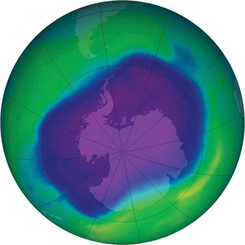
One of the largest ozone holes was observed in 2006 over Antarctica.
::2006年在南极上空观测到了最大的臭氧空洞之一。
This process also occurs naturally when volcanoes erupt and emit sulfur aerosols into the atmosphere. The sulfur aerosols break down CFCs and halon. This results in the release of chlorine and bromine, which deplete ozone molecules. In recent years, nitrous oxide has become a major chemical that can reach the stratosphere to act as an agent in the ozone depletion process.
::当火山爆发并将硫气雾剂排放到大气中时,这一过程自然也会发生,硫气雾剂会分解氟氯化碳和哈龙,从而释放出消耗臭氧分子的氯和溴,近年来,一氧化二氮已成为一种主要化学品,可以到达平流层,作为臭氧消耗过程中的一种制剂。Nitrous oxide can be released into the atmosphere from human activities such as the use of nitrogen fertilizers in agriculture or from vehicle exhaust from burning fossil fuels. Nitrous oxide is also released naturally from the soil or from ocean water.
::氧化亚氮可因人类活动而释放到大气中,如农业使用氮肥,或燃烧化石燃料的车辆废气中释放出氧化亚氮,氧化亚氮还自然地从土壤或海水中释放出来。Ozone depletion has been especially noticeable over Antarctica. A large area of ozone depletion in the upper atmosphere is often called an ozone hole. The ozone hole over Antarctica is not exactly a total depletion of ozone but a major reduction in the amount of ozone found in the stratosphere over the South Pole. Recent ozone levels in the stratosphere over Antarctica have decreased and are lower than they were in 1975.
::在南极上空,臭氧消耗特别明显,在高层大气中,臭氧消耗面积很大,通常称为臭氧空洞,南极上空的臭氧空洞并不是臭氧的完全消耗,而是南极上空平流层臭氧量的大幅减少,南极上空平流层臭氧水平最近下降,低于1975年的水平。Polar stratospheric clouds, which sometimes develop over Antarctica during the extremely cold winter months, severely reduce ozone levels. The clouds trap chlorine and nitric acid in their ice crystals. As the circulation of westerly winds starts in the spring, an atmospheric vortex is created over the polar area. The ozone hole increases during the spring when sunlight increases—from September to early December. The sunlight speeds up the chemical reactions that deplete the ozone molecules. During this time, as much as half of the lower stratospheric ozone can be destroyed, creating an ozone hole.
::极平流层云有时在极其寒冷的冬季月里在南极上空发展,这些云在极冷的冬季中严重减少臭氧水平。云层将氯和硝酸困在冰晶中。随着西风在春季的循环,在极地上空形成了大气旋涡。在阳光增加的春季,从9月到12月初,臭氧洞在增加。阳光加速了消耗臭氧分子的化学反应。在此期间,多达一半的低平流层臭氧可以被摧毁,造成臭氧洞。Global Impacts and Organizations
::全球影响和组织Many governments around the world have established agencies to address environmental issues and have invested resources in continued research and scientific discovery. Many nongovernmental agencies and organizations such as have also been established to address the development or management of Antarctica and to address environmental concerns.
::世界上许多国家政府已设立机构处理环境问题,并投入资源继续进行研究和科学发现,还设立了许多非政府机构和组织,例如处理南极洲的发展或管理以及处理环境问题的非政府组织。International organizations such as the have been formed to enhance cooperation between countries and concerned entities. In 1998, was established by the UNEP and the to address the work of the .
::1998年,环境规划署设立了国际组织,如为加强各国和有关实体之间的合作而成立的国际组织。Through an international treaty, the agency focuses on the harmful effects of climate change. One outcome of the UNFCCC’s work was the developed in 1997 in Kyoto, Japan, which created a legal commitment by participants to reduce greenhouse gases and address climate change issues. Enforcing the Kyoto Protocol is a matter of debate. The 2009 United Nations Climate Change Conference (also referred to as the Copenhagen Summit) was held in Denmark to address some of the same issues that were discussed in the Kyoto Protocol.
::通过一项国际条约,该机构侧重于气候变化的有害影响,《气候公约》工作的成果之一是1997年在日本京都开发的,使与会者在法律上承诺减少温室气体和解决气候变化问题,执行《京都议定书》是一个辩论事项,2009年联合国气候变化会议(又称哥本哈根首脑会议)在丹麦举行,讨论《京都议定书》中讨论的一些问题。Depletion of the stratospheric ozone over the polar regions or the thinning of the ozone layer over the mid-latitudes would have worldwide implications for human activity and environmental conditions. Climate change is not restricted to one country or one government; these and other environmental issues affect the whole planet and impact everyone, whether they are contributing to the problem or not.
::极地地区平流层臭氧的损耗或中纬度臭氧层的薄化将对人类活动和环境条件产生全球性影响,气候变化不限于一国或一国政府,这些问题和其他环境问题影响整个地球,影响到每一个人,无论它们是否助长这一问题。This is what Antarctica might look like if all the ice were removed. The physical area remaining is estimated by some to be about one hundred thousand square miles, which is about the same physical area as the US state of Colorado. It is unclear what the actual physical area would be if the ice melted.
::如果所有的冰都被清除,南极洲可能看起来就是如此。 据一些人估计,剩余的物理面积约为10万平方英里,这与美国科罗拉多州的物理面积大致相同。 如果冰融化,实际物理面积将是什么还不清楚。
If the sea level were to rise to the level predicted because of global warming, it would impact every country with a coastline in the world. It would not be restricted to any one category of country, developed or undeveloped. Issues of increased UV radiation or climate change are not restricted by political boundaries or economic conditions. They require global thinking and awareness and cannot be solved by one country alone.
::如果海平面由于全球变暖而上升到预计的水平,它就会影响到世界上每一个拥有海岸线的国家,它不会局限于任何一类国家,无论是发达国家还是欠发达国家,紫外线辐射增加或气候变化问题不受政治边界或经济条件的限制,它们需要全球思维和认识,不能单靠一个国家解决。Key Takeaways
::密钥外出-
Antarctica has the highest average elevation of any continent and has many mountains. The continent includes active volcanoes, high mountains, and the Trans-Antarctic Mountain range. The continent is surrounded by the Southern Ocean.
::南极洲是任何大陆平均海拔最高的地区,有许多山脉,包括活火山、高山和横贯南极山脉。 -
The ice sheet that covers Antarctica is more than a mile thick and holds about 70 percent of the earth’s fresh water. Antarctica is still considered a desert because it receives so little precipitation on an average basis. Large bodies of water are also located below the ice sheet.
::覆盖南极洲的冰盖超过一英里厚,占地球淡水的70%左右。 南极洲仍被视为沙漠,因为平均降水量很少。 大片水体也位于冰盖下方。 -
The concept of global warming is one aspect of climate change that indicates an increase in greenhouse gasses such as carbon dioxide, which help regulate the temperature of the earth’s atmosphere. The end result is warmer temperatures on the earth’s surface. The burning of fossil fuels is a main source of carbon dioxide that enters the atmosphere. Climate change may result in the melting of the polar ice sheet over Antarctica, which could raise sea levels considerably.
::全球变暖的概念是气候变化的一个方面,它表明二氧化碳等温室气体的增加有助于调节地球大气温度。 最终结果是地球表面温度升高。 化石燃料的燃烧是进入大气的二氧化碳的主要来源。 气候变化可能导致南极洲极地冰盖的融化,这可能会大大提升海平面。 -
Ozone in the stratosphere protects the earth from harmful UV radiation from the sun. Various chemicals reduce the amount of protective ozone in the stratosphere, which allows more UV radiation to reach the earth. A seasonal cycle varies the amount of ozone in the stratosphere over the South Pole, causing an ozone hole when ozone is not abundant.
::平流层中的臭氧保护地球免受太阳的有害紫外线辐射,各种化学品减少了平流层中保护臭氧的数量,使更多的紫外线辐射能够到达地球,季节性周期与南极平流层中的臭氧数量不同,在臭氧不充足时造成臭氧空洞。
Vocabulary Terms
::词汇术语术语Chapter 11.5 Antarctica
::第11.5章 南极洲Antarctic Treaty
::《南极南极条约》Treaty signed in 1959 the makes Antarctica a scientific preserve and prevents conflict from any nation from happening on the continent
::1959年签署的条约使南极洲成为科学保护区,防止任何国家在非洲大陆发生冲突ice shelfs
::冰架A floating sheet of ice permanently attached to a landmass
::永久固定在陆地上的漂浮冰层Wallace line
::华莱士线a faunal boundary line drawn in 1859 by the British naturalist Alfred Russel Wallace that separates the ecozones of Asia and Wallace, a transitional zone between Asia and Australia
::a 1859年英国自然学家Alfred Russel Wallace划定的动物边界线,该边界线将亚洲的生态区与亚洲与澳大利亚之间的过渡区Wallace划开。climate change
::气候变化气候变化a long-term change in the earth's climate, especially a change due to an increase in the average atmospheric temperature
::地球气候的长期变化,特别是平均大气温度升高导致的变化El Ni ñ o Southern Oscillation
::厄尔尼诺/南方涛动A systematic shift in atmospheric pressure, sea-surface temperature, and ocean circulation in the tropical Pacific Ocean. ENSO cycles give rise to El Nino and La Nino conditions. It is a global coupled ocean-atmosphere phenomenon and the effect on climate in the southern hemisphere is profound
::热带太平洋的大气压力、海表温度和海洋环流的系统变化,热带太平洋的大气压力、海表温度和海洋环流的系统变化,厄尔尼诺和拉尼诺的循环造成了厄尔尼诺和拉尼诺的气候条件。Applying Knowledge
::应用知识Interactive Notebook Activities
::互动笔记活动-
Describe
the layout of the continent’s main physical features, including the ice shelves and volcanic activity.
::描述非洲大陆主要物理特征的布局,包括冰架和火山活动。 -
List
the political nature of the various claims held on sections of Antarctica and
explain
how the continent is managed by the international community.
::列出对南极洲部分地区的各种主张的政治性质,并解释国际社会如何管理该大陆。 -
Summarize
briefly the dynamics of the principle of global warming and
describe
what changes would occur in Antarctica and the rest of the world if the ice sheet covering Antarctica were to melt.
::简要概述全球变暖原则的动态,并描述如果覆盖南极洲的冰盖融化,南极洲和世界其他地区将发生哪些变化。 -
Describe
how good ozone is depleted and
explain
the role Antarctica plays in the seasonal cycle of changes in the amount of ozone in the atmosphere above the South Pole.
::说明臭氧消耗情况如何良好,并解释南极洲在南极上空大气臭氧量变化的季节性循环中所起的作用。
Discussion and Study Questions
::讨论和研究问题-
Where are the main mountain ranges in Antarctica? What is significant about Mt. Erebus?
::南极洲的主要山脉在哪里?埃里布斯山有什么重要之处? -
How can Antarctica be considered a desert region with all that ice? How thick is the ice sheet?
::南极洲如何能被视为有那么多冰的沙漠地区?冰盖有多厚? -
What percentage of the world’s fresh water is located in Antarctica?
::世界上有多少百分比的淡水位于南极洲? -
What was the Antarctic Treaty designed to accomplish? Who agreed to the treaty?
::《南极条约》的目的是实现什么?谁同意该条约? -
What seven countries have laid claims to the territory of Antarctica?
::哪些七个国家对南极洲领土提出主张? -
How does the burning of fossil fuels contribute to climate change?
::燃烧化石燃料如何促成气候变化? -
How would continued global warming affect Antarctica and the rest of the planet?
::持续的全球变暖将如何影响南极洲和地球其他部分? -
How does ozone protect the planet? What damage would ozone depletion cause?
::臭氧如何保护地球?臭氧消耗会造成什么损害? -
Why is there an ozone hole over the South Pole during certain months?
::为什么在某些月里 南极上空会有臭氧空洞? -
What does the Kyoto Protocol attempt to accomplish?
::《京都议定书》试图实现什么目标?
Real-World Geography Exercise
::现实世界地理演习Using , determine the latitude and longitude for each location on the list below.
::使用,确定以下列表中每个位置的纬度和经度。-
Antarctic Peninsula
::南极半岛 -
East Antarctica
::东南极洲 -
Ellsworth Mountains
::埃尔斯沃斯山 -
Lake Vostok
::沃斯托克湖 -
Mount Erebus
::Erebus 山 -
Mount Vinson
::文森山 -
Ronne Ice Shelf
::Ronon Ice 大陆架 -
Ross Ice Shelf
::罗斯冰架 -
Southern Ocean
::南南大洋 -
South Pole
::南极 -
Transantarctic Mountains
::跨极山 -
West Antarctica
::西南极洲
Videos for Geography Enrichment
::地理丰富视频Helpful Websites for the Study of Geography
::地理研究有用网站is an encyclopedia funded by the Canadian government covering all branches of knowledge. Their scholarly collection includes interactive materials.
::该百科全书由加拿大政府资助,涵盖所有知识分支,其学术收藏包括交互式材料。provides information on the people, history, government, economy, energy, geography, communications, transportation, military, and transnational issues for the world's entities.
::向世界各实体提供关于人民、历史、政府、经济、能源、地理、通信、运输、军事和跨国问题的资料。is a US government website where you can find federal legislation, past and present, as well as information about the US legal system.
::是一个美国政府的网站,您可以在此找到过去和现在的联邦立法以及关于美国法律制度的信息。is a government agency website that provides current news, resources, topics of interest, information about drugs, careers in the DEA, and a tip hotline.
::是一个政府机构网站,提供最新消息、资源、感兴趣的话题、毒品信息、在缉毒局的职业以及一条小费热线。is the largest library in the world and provides manuscripts, files, information, pictures, and videos.
::图书馆是世界上最大的图书馆,提供手稿、文件、信息、图片和录像。is a US government agency website that allows users to search for and retrieve satellite images of Earth.
::这是一个美国政府机构的网站,用户可以搜索和检索地球的卫星图像。is a US government website that provides historical documents, photos, records, publications, and educator resources.
::这是一个美国政府网站,提供历史文件、照片、记录、出版物和教育资源。is a US government agency website that provides weather-related information and ocean research.
::是一个提供气象信息和海洋研究的美国政府机构网站。is a website by the United States Geological Survey and other federal, state, and local agencies that delivers topographic information for the United States.
::这是美国地质调查局和其他联邦、州和地方机构为美国提供地形信息的网站。is a massive central data source and a handy way to graphically compare nations.
::是一个庞大的中央数据源,是用图形比较国家的一种方便方式。is a website that measures most locations in the world for air pollution in real time.
::是一个实时测量世界上大多数空气污染地点的网站。is a unique statistical database, which allows you to research and compare a multitude of different data on US states.
::这是一个独特的统计数据库, 使你能够研究和比较关于美国各州的多种不同数据。is an international organization founded in 1945 and made up of 193 member states. The UN maintains international peace and security, protects human rights, delivers humanitarian aid, promotes sustainable development, and upholds international law.
::联合国是一个国际组织,成立于1945年,由193个成员国组成。 联合国维护国际和平与安全,保护人权,提供人道主义援助,促进可持续发展,维护国际法。is a US government agency that provides a population clock, data, surveys, statistics, a library with information and infographics, news about the economy, and much more.
::这是一个美国政府机构,它提供人口钟、数据、调查、统计、一个拥有信息和信息资料的图书馆、关于经济的新闻,以及更多。is a US government agency website that provides scientific information about the natural hazards that threaten lives, the natural resources we rely on, the health of our ecosystems and environment, and the impacts of climate and land-use change.
::这是一个美国政府机构的网站,提供科学信息,说明威胁生命的自然危害、我们赖以生存的自然资源、生态系统和环境的健康以及气候和土地使用变化的影响。is a US government website that provides the latest presidential news, information about the budget, policy, defense, and many more topics.
::提供最新总统新闻、预算、政策、国防等资讯, 以及更多议题。is under the United Nations and provides leadership on matters critical to health; shapes the research agenda on health; and monitors the health situation and assessing health trends around the world. Their website provides information on the state of health around the world, outbreaks, current health news, and more.
::他们的网站提供世界各地卫生状况、疫情爆发、最新卫生新闻等信息。is an intergovernmental organization that regulates international trade. The website provides information on the history of the multilateral trading system, featured videos, news and events, trade topics, and more.
::该网站提供关于多边贸易体系历史的信息、视频、新闻和事件、贸易专题等等。 -
Describe the layout of the continent’s main physical features, including the ice shelves and volcanic activity.