9.6表面电流
章节大纲
-
What can debris tell us about surface currents?
::碎片能告诉我们什么是表面洋流?The surface of the ocean is on the move. One way to see this is when something is dumped in the ocean. Where will it end up? The that struck Japan in March 2011 pulled a lot of material into the ocean. The image above is a model created in April 2012. The orange and red are where floating debris might be. Scientists are creating models of where the debris will go. But no one knows for sure where it will go or when it will get there.
::海洋表面正在移动。 一种观察方式是当某物被倾弃在海洋中时。 它最终会到哪里去? 2011年3月袭击日本的日本将许多物质拖入海洋。 上面的图像是2012年4月创建的模型。 橙色和红色是漂浮碎片可能存在的地方。 科学家正在创建碎片去向的模型。 但是没有人知道碎片会往哪里去,或何时到那里去。Surface Currents
::地表洋流Like air in the atmosphere , ocean water moves in currents. A current is a stream of moving water that flows through the ocean. Surface currents are caused mainly by winds but not daily winds. Surface currents are caused by the major wind belts. These winds blow in the same direction all the time. So they can keep water moving in the same direction.
::与大气中的空气一样,海洋水在水流中移动。水流是流动水流,在海洋中流动。地表水流主要是由风而不是天风造成的。地表水流是由主要风带造成的。这些风向一直向同一方向吹动。这样,水能保持同一方向。Surface currents are created by three things:
::地表洋流由三件事形成:- global wind patterns
::全球风气模式
- the rotation of the Earth
::地球旋转
- the shape of the ocean basins
::海洋盆地的形状
Surface currents are extremely important because they distribute heat around the planet . Surface currents also have a tremendous influence on climate around the globe.
::地表洋流极为重要,因为它们在地球周围分配热量,地表洋流对全球气候也有着巨大影响。Global Wind Patterns
::全球风势模式Winds on Earth are either global or local. Global winds blow in the same directions all the time. They are created when more solar energy strikes the equator than the polar regions. More about global wind patterns is described in detail in the concept " ."
::地球上的风是全球性的,或者是局部性的。全球风吹向相同的方向。当太阳能撞击赤道而不是极地地区时,它们就会形成。关于全球风势的更多内容在“概念”中详细描述。The major wind belts push the water in the surface currents. The water moves in the direction of :
::主要风带将水推向地表水流。- trade winds: east to west between the equator and 30°N and 30°S.
::风:赤道与北纬30°和西经30°之间的东向西。
- westerlies: west to east in the middle latitudes.
::湿虫:中纬度以西至东。
- polar easterlies: east to west between 50° and 60° north and south of the equator and the North and South Poles.
::东极:赤道以北50度至60度之间,东向西,赤道以南,北极和南极。
Earth's Rotation
::地球的旋转The rotation of the Earth—that is, the —causes the ocean currents to turn. More information about the phenomenon can be found in the concept "Coriolis Effect."
::地球的旋转——也就是说——导致洋流的转动。关于这一现象的更多信息可以在“Coriolis effect”的概念中找到。Shape of the Ocean Basins
::海洋盆地的形状A surface current move across the ocean. Eventually, the current runs into land ( Figure ). When it does, it turns right in the Northern Hemisphere and left in the Southern Hemisphere . The direction is due to Coriolis effect.
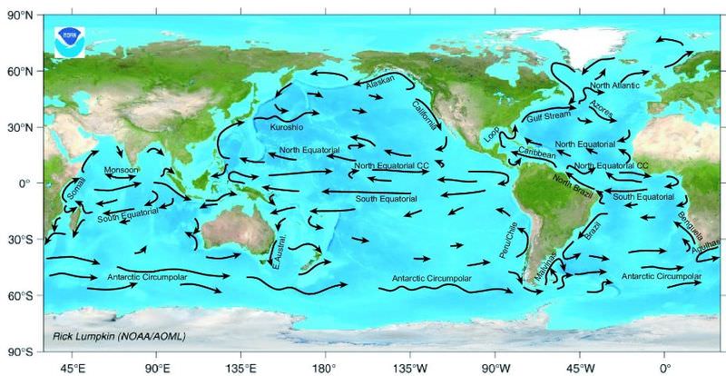
::表面洋流在海洋中移动。 最终, 水流会流入陆地( 图 ) 。 当它进入时, 它会在北半球右转, 在南半球左转。 方向是由 Coriolis 效应决定的 。The major surface ocean currents. Gyres
::Gyres 灰度The major surface currents are pictured below ( Figure ). There are five major gyres , or loops, which flow in a clockwise direction in the Northern Hemisphere. In the Southern Hemisphere, they flow in the opposite direction. Only the Antarctic Circumpolar Current flows nonstop around the globe.
::主要地表洋流图示如下(图 ) 。 北半球有五支主要旋翼或环, 顺时针向北半球流动。 在南半球, 它们向相反的方向流动。 只有南极北极洋流在全球无休止地流动 。Earth’s surface currents flow in the patterns shown here. Local Surface Currents
::当地海面海流Currents are also found along shorelines ( Figure ). They are not related to the global wind belts. Two are longshore currents and rip currents .
::沿海岸线(图)也发现了洋流,它们与全球风带无关,两个是远岸洋流和裂流。Longshore currents move water and sediment parallel to the shore. They move in the direction of the prevailing local winds. Rip currents are very dangerous currents! Rip currents move large amounts of water offshore quickly. Each summer in the United States, at least a few people die when they are caught in rip currents. Rip currents are too strong for humans to swim against. The best way to escape a rip current is to swim sideways, parallel to the shoreline until you are out of the current and can follow the breaking waves back to the shore.
::裂流是非常危险的海流!裂流迅速将大量水流移离岸外。 每年夏天,在美国,至少有一些人在被裂流困住时死亡。 裂流太强大,人类无法游泳对抗。 摆脱裂流的最佳办法是游过侧面,与海岸线平行,直到你脱离海流,并跟随破碎的波浪返回岸边。Summary
::摘要- Major surface ocean currents are the result of global wind patterns, Earth's rotation, and the shape of the ocean basins.
::主要地表洋流是全球风势、地球旋转和海洋盆地形状的结果。
- Major surface currents circle the oceans in five gyres.
::主要表面洋流以5个旋翼环绕海洋。
- Local surface currents, like longshore and rip currents, move near shorelines.
::当地地表水流,如远岸和冲浪水流,靠近海岸线。
Review
::回顾- Why does the North Pacific gyre move the way it does?
::为什么北太平洋的旋翼 移动的方式?
- What should you do if you get stuck in a rip current? Why?
::如果你被流水缠住怎么办?
- Why is the Antarctic Circumpolar Current different from other surface currents? What would surface currents look like if there were no continents?
::为什么南极北极洋流与其他表面洋流不同?如果没有大陆,洋流会是什么样子?
Explore More
::探索更多Use the resource below to answer the questions that follow.
::利用以下资源回答以下问题。- What is a surface current?
::什么是表面水流?
- What is a thermocline?
::什么是热电线?
- Where is the thermocline?
::热电线在哪里?
- How do surface currents form?
::表面水流如何形成 ?
- What factors determine the movement of surface currents?
::哪些因素决定地表水流的移动?
- Why are currents different temperatures?
::为什么海流的温度不同?
- How do surface currents affect climate?
::地表水流如何影响气候?
- How are the currents monitored by NASA?
::美国航天局如何监测洋流?
- global wind patterns